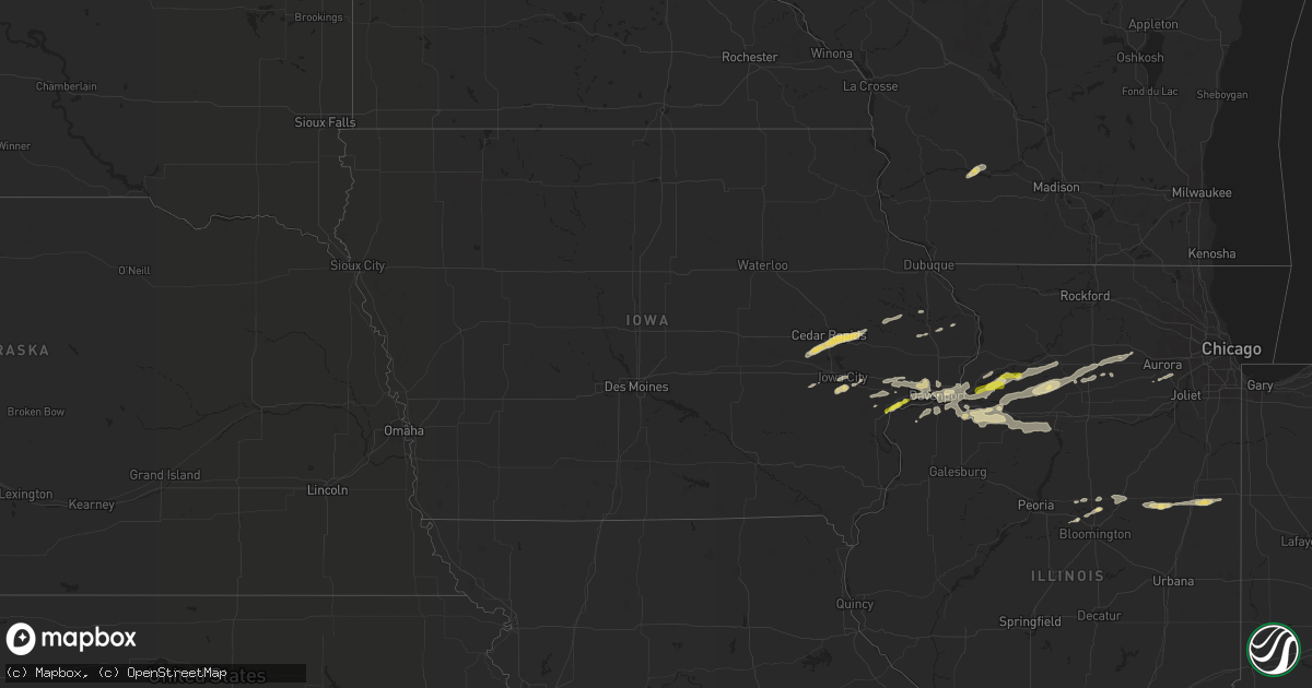
Hail Map in Iowa on April 22, 2019
Get this storm
April 22 map
$229
one time, instant access
Download today. No call, no setup
Keep the $229
Bought the map and want the full workflow? Apply the entire $229 to a subscription within 7 days. None of it is wasted.
Every map, not just this one
This buys you this map. Subscription and you get every map we run, in the markets you choose from a few cities to whole states to nationwide. Plus real-time alerts the moment a storm fires.
Contact data
Name, contact info, occupancy, even credit band for addresses in the footprint. You go from where it hit to who to call.
Become the source they trust
Unlimited branding weather history reports on demand. You already have the documented answer ready for the property owner, and you are the one who showed up with it.
Property data and RoofTrace estimates
Pull up any address you have got, its value and the exact code rules for that jurisdiction, straight from One Click Code. Then RoofTrace estimates the squares, pitch, and roof value, priced the way you price.
Storm reports in Iowa
Iowa
| Date | Description |
|---|---|
| 04/22/20196:05 PM CDT | A local report indicates 60 MPH wind near DELMAR |
| 04/22/20195:11 PM CDT | Trees and tree branches down at maquoketa caves state park. Delayed report. |
| 04/22/20194:51 PM CDT | Signs and tree limbs down on e29 east of onslow. |
| 04/22/20194:27 PM CDT | Wind moved a fire truck |
| 04/22/20194:15 PM CDT | Tree down in mt vernon from thunderstorm winds. Picture was from social media. Time estimated from radar. |
| 04/22/20193:58 PM CDT | Power poles and lines down |
| 04/22/20192:08 PM CDT | A local report indicates 1.00 inch wind near 3 ENE MUSCATINE |
| 04/22/20191:46 AM CDT | At 646 PM CDT, severe thunderstorms were located along a line extending from Calamus to 6 miles north of Walcott to near Muscatine, moving east at 35 mph. HAZARD...60 mph wind gusts and penny size hail. SOURCE...Radar indicated. IMPACT...Expect damage to roofs, siding, and trees. Locations impacted include... Davenport, Moline, Rock Island, Bettendorf, Clinton, Muscatine, East Moline, Durant, Silvis, Eldridge, DeWitt, Milan, Camanche, Le Claire, Coal Valley, Wilton, Hampton, Port Byron, Walcott and Blue Grass.This includes the following highways... Interstate 74 in Iowa between mile markers 1 and 5. Interstate 80 in Iowa between mile markers 271 and 306. Interstate 80 in Illinois near mile marker 1. Interstate 74 in Illinois between mile markers 1 and 7. Interstate 280 between mile markers 1 and 18. |
| 04/22/201912:59 AM CDT | At 558 PM CDT, a severe thunderstorm was located over Delmar, or near Maquoketa, moving east at 50 mph. HAZARD...60 mph wind gusts and penny size hail. SOURCE...Radar indicated. IMPACT...Expect damage to roofs, siding, and trees. Locations impacted include... Maquoketa, Mount Carroll, Savanna, Preston, Fairhaven, Sabula, Chadwick, Delmar, Miles, Charlotte, Springbrook, Andover, Spragueville, Hurstville, Green Island, Argo Fay, Van Buren, Thomson, Goose Lake and Wacker. |
| 04/22/201912:09 AM CDT | At 508 PM CDT, severe thunderstorms were located along a line extending from near Bernard to near Hurstville, moving northeast at 50 mph. HAZARD...60 mph wind gusts and penny size hail. SOURCE...Radar indicated. IMPACT...Expect damage to roofs, siding, and trees. Locations impacted include... Galena, Bellevue, Stockton, Warren, Hanover, Elizabeth, Woodbine, Andrew, Scales Mound, Apple River, La Motte, Council Hill, St. Donatus, Nora, Bernard, Zwingle, Fulton, Schapville, Guilford and Rice. |
| 04/22/201912:00 AM CDT | At 500 PM CDT, a severe thunderstorm was located 8 miles east of Parnell, or 16 miles west of Iowa City, moving east northeast at 40 mph. HAZARD...60 mph wind gusts and quarter size hail. SOURCE...Radar indicated. IMPACT...Hail damage to vehicles is expected. Expect wind damage to roofs, siding, and trees. Locations impacted include... Iowa City, Coralville, North Liberty, Williamsburg, Solon, Tiffin, University Heights, North English, Oxford, Hills, Parnell, Oakdale, Lake Macbride State Park, Newport, Frytown, Windham, Sugar Bottom Camp Ground, Johnson County Fairgrounds, Sutliff and F.W. Kent Park.This includes the following highways... Interstate 80 in Iowa between mile markers 223 and 253. Interstate 380 between mile markers 1 and 5. |
| 04/21/201911:19 PM CDT | At 419 PM CDT, a severe thunderstorm was located over Martelle, or 9 miles northwest of Mechanicsville, moving east at 35 mph. HAZARD...Ping pong ball size hail and 60 mph wind gusts. SOURCE...Radar indicated. IMPACT...People and animals outdoors will be injured. Expect hail damage to roofs, siding, windows, and vehicles. Expect wind damage to roofs, siding, and trees. Locations impacted include... Anamosa, Mechanicsville, Marion, Mount Vernon, Lisbon, Springville, Olin, Wyoming, Oxford Junction, Lost Nation, Bertram, Martelle, Onslow, Monmouth, Morley, Center Junction, Stone City, Viola, Whittier and Nashville. |
| 04/21/201910:30 PM CDT | At 330 PM CDT, a severe thunderstorm was located over Amana, or 9 miles east of Marengo, moving northeast at 40 mph. HAZARD...60 mph wind gusts and quarter size hail. SOURCE...Radar indicated. IMPACT...Hail damage to vehicles is expected. Expect wind damage to roofs, siding, and trees. Locations impacted include... Cedar Rapids, Marion, Hiawatha, Mount Vernon, Robins, Lisbon, Fairfax, Ely, Walford, Springville, Swisher, Shueyville, Norway, Bertram, Amana, Viola, Whittier, Middle Amana, Squaw Creek Park and East Amana.This includes Interstate 380 between mile markers 8 and 25. |
| 04/21/201910:26 PM CDT | At 325 PM CDT, a severe thunderstorm was located near Van Horne, or near Vinton, moving northeast at 40 mph. A second severe thunderstorm was located southwest of Monti moving northeast. HAZARD...Quarter size hail. SOURCE...Radar indicated. IMPACT...Damage to vehicles is expected. Locations impacted include... Vinton, Manchester, Center Point, Urbana, Edgewood, Winthrop, Walker, Van Horne, Quasqueton, Lamont, Colesburg, Garrison, Rowley, Greeley, Dundee, Masonville, Troy Mills, Oneida, Vinton Memorial Airport and Manchester Airport.This includes Interstate 380 between mile markers 38 and 50. |
| 04/21/201910:10 PM CDT | At 309 PM CDT, a severe thunderstorm was located near Port Byron, or 12 miles east of Bettendorf, moving northeast at 45 mph. HAZARD...Quarter size hail. SOURCE...Radar indicated. IMPACT...Damage to vehicles is expected. Locations impacted include... Morrison, Prophetstown, Port Byron, Erie, Garden Plain, Rapids City, Tampico, Cordova, Lyndon, Emerson, Union Grove, Ustick, Fenton, Hillsdale, Round Grove, Portland Corners, Spring Hill, Malvern, Como and White Pigeon.This includes Interstate 88 between mile markers 2 and 39. |
| 04/21/20199:10 PM CDT | At 210 PM CDT, a severe thunderstorm was located over Muscatine, moving northeast at 40 mph. HAZARD...Quarter size hail. SOURCE...Radar indicated. IMPACT...Damage to vehicles is expected. Locations impacted include... Davenport, Moline, Rock Island, Bettendorf, Muscatine, East Moline, Silvis, Eldridge, Milan, Le Claire, Hampton, Port Byron, Walcott, Blue Grass, Buffalo, Andalusia, Rapids City, Princeton, Long Grove and Riverdale.This includes the following highways... Interstate 74 in Iowa between mile markers 1 and 5. Interstate 80 in Iowa between mile markers 282 and 306. Interstate 80 in Illinois between mile markers 1 and 5. Interstate 74 in Illinois between mile markers 1 and 4. Interstate 88 between mile markers 1 and 7. Interstate 280 between mile markers 1 and 18. |
| 04/21/20197:00 PM CDT | A local report indicates 65 MPH wind near 2 NNW WALCOTT |
All States Impacted by Hail Map on April 22, 2019
Cities Impacted by Hail Map on April 22, 2019
- Martelle, IA
- Anamosa, IA
- Lisbon, IA
- Fairfax, IA
- Cedar Rapids, IA
- Mount Vernon, IA
- Ely, IA
- Norway, IA
- Walford, IA
- Swisher, IA
- Marion, IA
- Amana, IA
- Oswego, IL
- Prophetstown, IL
- Erie, IL
- Geneseo, IL
- Tampico, IL
- Eureka, IL
- Paw Paw, IL
- Wilton, IA
- Moscow, IA
- Davenport, IA
- Blue Grass, IA
- Stockton, IA
- Durant, IA
- Walcott, IA
- Justiceburg, TX
- Rock Island, IL
- Seagraves, TX
- Seminole, TX
- Annawan, IL
- Mangum, OK
- Lone Wolf, OK
- Blair, OK
- Iowa City, IA
- Fairbury, IL
- Milford, IL
- Chatsworth, IL
- Piper City, IL
- Roberts, IL
- Strawn, IL
- Forrest, IL
- Crescent City, IL
- Onarga, IL
- Watseka, IL
- Gilman, IL
- Thawville, IL
- Harmon, IL
- Riverside, IA
- Hills, IA
- Post, TX
- Gridley, IL
- Maquoketa, IA
- Yorkville, IL
- Dixon, IL
- Amboy, IL
- La Moille, IL
- Walnut, IL
- Sublette, IL
- Ohio, IL
- Aspermont, TX
- Atkinson, IL
- Muscatine, IA
- Roosevelt, OK
- Hampton, IL
- Moline, IL
- Port Byron, IL
- Bettendorf, IA
- Pleasant Valley, IA
- East Moline, IL
- Danvers, IL
- Illinois City, IL
- Cambridge, IL
- Kewanee, IL
- Milan, IL
- Parnell, IA
- Oxford, IA
- Earlville, IL
- Leland, IL
- Brighton, MI
- Lone Rock, WI
- Spring Green, WI
- Avoca, WI
- Coal Valley, IL
- Hudson, IL
- Reynolds, IL
- Mendota, IL
- Compton, IL
- West Brooklyn, IL
- Carlock, IL
- Lexington, IL
- Tahoka, TX
- Osco, IL
- Orion, IL
- West Branch, IA
- Chenoa, IL
- Waterman, IL
- Hobart, OK
- Dekalb, IL
- Lee, IL
- Shabbona, IL
- Onslow, IA
- Center Junction, IA
- Wyoming, IA
- Colona, IL
- Princeton, IL
- Tiskilwa, IL
- Secor, IL
- El Paso, IL
- Naperville, IL
- Plainfield, IL
- Sheffield, IL
- Odonnell, TX
- Snyder, TX
- Gail, TX
- Eldridge, IA
- Hinckley, IL
- Granite, OK
- New Bedford, IL
- Hillsdale, IL
- Buda, IL
- Rapids City, IL
- Le Claire, IA
- Silvis, IL
- Mineral, IL
- Rock Falls, IL
- Neponset, IL
- Carbon Cliff, IL
- Steward, IL
- Maple Park, IL
- Delmar, IA
- Charlotte, IA
- Atalissa, IA
- West Liberty, IA
- Lost Nation, IA
- Taylor Ridge, IL
- Preston, IA
- Tarzan, TX
- Lamesa, TX
- Andrews, TX
- Jal, NM
- Ackerly, TX
- Panguitch, UT


