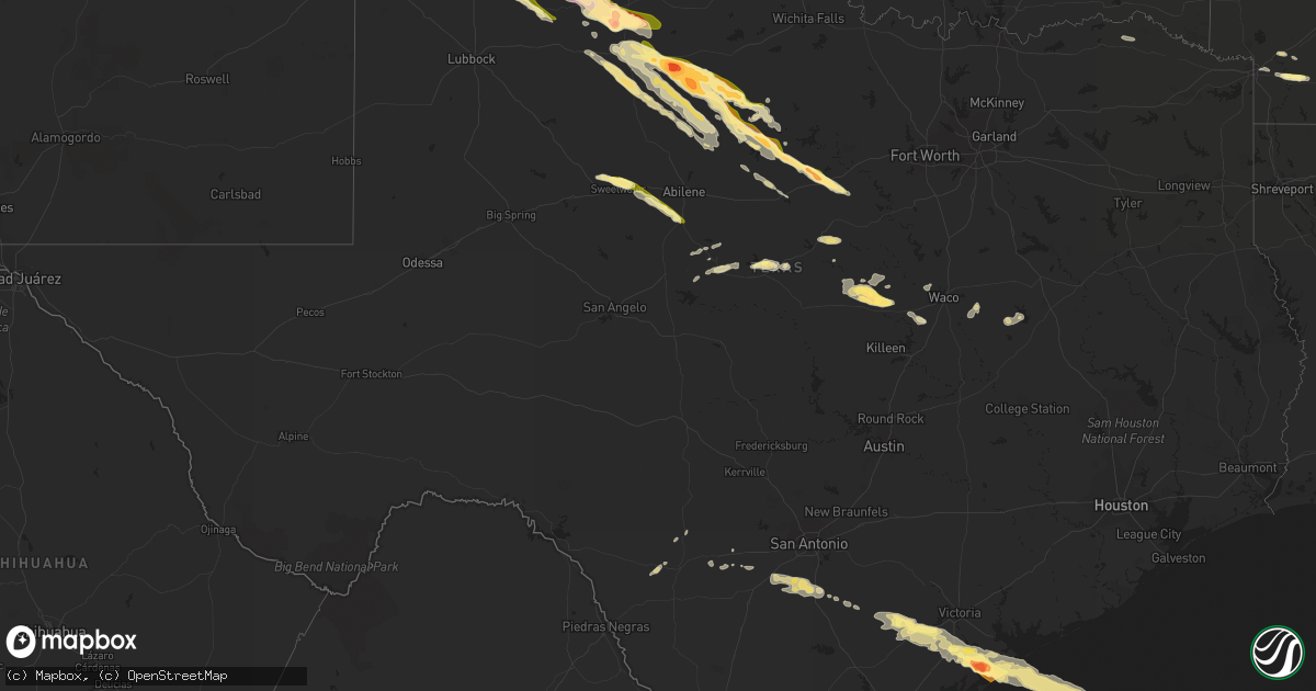
Hail Map in Texas on April 22, 2015
Get this storm
April 22 map
$229
one time, instant access
Download today. No call, no setup
Keep the $229
Bought the map and want the full workflow? Apply the entire $229 to a subscription within 7 days. None of it is wasted.
Every map, not just this one
This buys you this map. Subscription and you get every map we run, in the markets you choose from a few cities to whole states to nationwide. Plus real-time alerts the moment a storm fires.
Contact data
Name, contact info, occupancy, even credit band for addresses in the footprint. You go from where it hit to who to call.
Become the source they trust
Unlimited branding weather history reports on demand. You already have the documented answer ready for the property owner, and you are the one who showed up with it.
Property data and RoofTrace estimates
Pull up any address you have got, its value and the exact code rules for that jurisdiction, straight from One Click Code. Then RoofTrace estimates the squares, pitch, and roof value, priced the way you price.
Storm reports in Texas
Texas
| Date | Description |
|---|---|
| 04/22/20156:55 PM CDT | Measured by the west texas mesonet. |
| 04/22/20156:51 PM CDT | Dime to ping pong size hail reported on highway 207 in wayside. |
| 04/22/20156:48 PM CDT | A local report indicates 1.50 inch wind near 3 NW GATESVILLE |
| 04/22/20156:47 PM CDT | I27 covered in hail up to 4-6 in deep from happy to near tulia |
| 04/22/20156:25 PM CDT | Report of tennis ball to baseball size hail in and around happy. |
| 04/22/20156:25 PM CDT | Power lines down in town |
| 04/22/20156:23 PM CDT | A local report indicates 1.75 inch wind near HAPPY |
| 04/22/20156:20 PM CDT | A local report indicates a tornado near 6 NNW ROSCOE |
| 04/22/20156:19 PM CDT | Reported by media. |
| 04/22/20156:18 PM CDT | Landspout reported by public with a picture posted on facebook media |
| 04/22/20156:18 PM CDT | A local report indicates 3.00 inch wind near 11 SSW CANYON |
| 04/22/20156:15 PM CDT | Golfball hail at frost ranch...quarter mile north of randall/potter county line. |
| 04/22/20156:10 PM CDT | A local report indicates 1.00 inch wind near 11 SSW CANYON |
| 04/22/20156:07 PM CDT | Half dollar to ping pong ball size hail reported. |
| 04/22/20155:59 PM CDT | Along highway 60 northeast of hereford |
| 04/22/20155:54 PM CDT | A local report indicates 1.00 inch wind near 5 E HEREFORD |
| 04/22/20155:48 PM CDT | Three inch diameter tree limbs down |
| 04/22/20155:42 PM CDT | Windblown golfball size hail caused damage to many windows and businesses/homes in austwell. Metal garage blown over. Large trees down. Numerous powerlines down through |
| 04/22/20155:41 PM CDT | A local report indicates 1.00 inch wind near DAWN |
| 04/22/20155:37 PM CDT | Quarter to golfball size hail reported sw of dawn on highway 60. |
| 04/22/20155:35 PM CDT | Co op observer in austwell suffered roof damage to home from strong thunderstorm wind gusts |
| 04/22/20155:34 PM CDT | Windblown golfball size hail caused damage to many windows and businesses/homes in austwell. Metal garage blown over. Large trees down. Numerous powerlines down through |
| 04/22/20155:33 PM CDT | Co op observer in austwell suffered roof damage to home from strong thunderstorm wind gusts |
| 04/22/20155:20 PM CDT | A local report indicates 59 MPH wind near 2 WNW HEREFORD |
| 04/22/20155:20 PM CDT | A local report indicates 59 MPH wind near 5 ENE HEREFORD |
| 04/22/20155:19 PM CDT | Reported nickel to quarter size hail and rotating wall cloud |
| 04/22/20155:16 PM CDT | A local report indicates 1.00 inch wind near 4 N HEREFORD |
| 04/22/20155:15 PM CDT | A local report indicates 65 MPH wind near 2 WNW HEREFORD |
| 04/22/20154:43 PM CDT | Powerlines down across goliad. |
| 04/22/20154:42 PM CDT | A local report indicates 1.00 inch wind near GOLIAD |
| 04/22/20154:35 PM CDT | Many large trees snapped at goliad state park. Flooding in the mission church and bell tower. |
| 04/22/20153:18 PM CDT | A local report indicates 1.00 inch wind near 2 S COLEMAN |
| 04/22/20152:04 PM CDT | Few large trees down |
| 04/22/20151:44 PM CDT | Power poles down along fm665 and fm43. |
| 04/22/20151:32 PM CDT | Reported along chapman ranch road before staples. Time est from radar. |
| 04/22/20151:31 PM CDT | Straight line wind/downburst damage along fm665 and fm43. This resulted in numerous power poles and lines to be blown down. |
| 04/22/20151:30 PM CDT | Quarter inch hail at london elementary school |
| 04/22/20151:26 PM CDT | Farm property damage near intersection of fm38 and 81. |
| 04/22/20151:26 PM CDT | Preliminary results from nws storm survey indicate 70 mph straight line wind damage near intersection of fm38 and 81. Results are not yet final. |
| 04/22/20151:14 PM CDT | A local report indicates 1.00 inch wind near ROBSTOWN |
| 04/22/201512:55 AM CDT | Half way between breckenridge and caddo damage done to garage door and an out building was moved |
| 04/22/201512:55 AM CDT | Telephone pole snapped in half. Shingles off roof of home. Horse trailer pushed 30 feet. Wellhouse roof ripped off. |
| 04/21/201511:29 PM CDT | A local report indicates 1.75 inch wind near 3 N THROCKMORTON |
| 04/21/201511:01 PM CDT | A local report indicates 2.75 inch wind near WEINERT |
| 04/21/201510:43 PM CDT | A local report indicates 2.00 inch wind near KNOX CITY |
| 04/21/201510:38 PM CDT | A local report indicates 3.00 inch wind near 5 N KNOX CITY |
| 04/21/201510:30 PM CDT | The public reported |
| 04/21/201510:20 PM CDT | Roof blown off barn at four sixes ranch. Time estimated. |
| 04/21/201510:19 PM CDT | Brief touchdown. Relayed by nws employee |
| 04/21/20159:50 PM CDT | A brief rope tornado reported by knox county em |
| 04/21/20159:33 PM CDT | Hail covering the road. |
| 04/21/20159:10 PM CDT | Ground covered in golfball to baseball size hail. Vehicles damaged. Time estimated. |
| 04/21/20159:06 PM CDT | Reported by cottle county emergency management. |
| 04/21/20158:47 PM CDT | A local report indicates 1.00 inch wind near TUSCOLA |
| 04/21/20158:35 PM CDT | A local report indicates 1.25 inch wind near 6 SSW BUFFALO GAP |
| 04/21/20158:30 PM CDT | Truck blown over on us 62 70. |
| 04/21/20158:30 PM CDT | Part of roof removed from house. Several large trees damaged. |
| 04/21/20158:30 PM CDT | A local report indicates 1.00 inch wind near 3 N MATADOR |
| 04/21/20158:30 PM CDT | One inch diamter hail reported at the time of wind report. |
| 04/21/20158:15 PM CDT | Windows broken in at least four houses in town |
| 04/21/20158:08 PM CDT | Truncated elephant trunk tornado briefly touched down. |
| 04/21/20158:02 PM CDT | Report received via spotternetwork. |
| 04/21/20157:53 PM CDT | Brief touchdown. Rotating dirt on the ground beneath well-defined funnel. |
| 04/21/20157:52 PM CDT | Windshield gone |
| 04/21/20157:32 PM CDT | A local report indicates 1.75 inch wind near PLAINVIEW |
| 04/21/20157:30 PM CDT | A local report indicates 1.00 inch wind near PLAINVIEW |
| 04/21/20157:07 PM CDT | At mile marker 82 on i27 |
All States Impacted by Hail Map on April 22, 2015
Cities Impacted by Hail Map on April 22, 2015
- Albany, TX
- Fyffe, AL
- Rainsville, AL
- O'Brien, TX
- Knox City, TX
- Weinert, TX
- Seymour, TX
- Haskell, TX
- Munday, TX
- El Dorado, AR
- Dublin, TX
- Pleasanton, TX
- Poteet, TX
- Duncan, OK
- Paducah, TX
- Old Glory, TX
- Aspermont, TX
- Plainview, TX
- Lockney, TX
- Junction City, AR
- Happy, TX
- Wayside, TX
- Claude, TX
- Marlow, OK
- Elgin, OK
- Lawton, OK
- Fletcher, OK
- Dimmitt, TX
- Tulia, TX
- Nazareth, TX
- Sweetwater, TX
- Trent, TX
- Orange Grove, TX
- San Diego, TX
- Breckenridge, TX
- Roscoe, TX
- Gatesville, TX
- Alta, CA
- Matador, TX
- Marion, LA
- Farmerville, LA
- Bastrop, LA
- Monroe, LA
- Delhi, LA
- Rayville, LA
- Oak Ridge, LA
- Tallulah, LA
- Spearsville, LA
- Collinston, LA
- Sterlington, LA
- Prescott, AR
- Belvidere, TN
- Flomot, TX
- Lewisville, AR
- Ingleside, TX
- Corpus Christi, TX
- Early, TX
- Brownwood, TX
- Blanket, TX
- Lillie, LA
- Epps, LA
- Magnolia, AR
- Moody, TX
- McGregor, TX
- Robstown, TX
- Bishop, TX
- Lake Providence, LA
- Sondheimer, LA
- Canyon, TX
- Loco, OK
- Dalhart, TX
- Garland City, AR
- Texarkana, AR
- Stamps, AR
- Newcastle, TX
- Lipan, TX
- Strawn, TX
- Santo, TX
- Graham, TX
- Mingus, TX
- Bluff Dale, TX
- Goree, TX
- Rochester, TX
- Rule, TX
- Gordon, TX
- Ranger, TX
- Woodson, TX
- Caddo, TX
- Stephenville, TX
- Throckmorton, TX
- Stamford, TX
- Buffalo Gap, TX
- Tuscola, TX
- Ovalo, TX
- Merkel, TX
- Abilene, TX
- Jonesboro, TX
- Eastland, TX
- Cisco, TX
- Sunray, TX
- Quitaque, TX
- Neosho, MO
- Stella, MO
- Granby, MO
- Silverton, TX
- Coleman, TX
- Clayton, NM
- Floresville, TX
- Riesel, TX
- Mart, TX
- Tivoli, TX
- Clifton, TX
- Hartley, TX
- Valley Mills, TX
- Hamilton, TX
- Turkey, TX
- Seadrift, TX
- Austwell, TX
- Port Lavaca, TX
- Rockport, TX
- Floydada, TX
- Hale Center, TX
- May, TX
- Stratford, TX
- Goliad, TX
- Runge, TX
- Devine, TX
- Hondo, TX
- Santa Anna, TX
- China Spring, TX
- Crawford, TX
- Waco, TX
- Kress, TX
- Hereford, TX
- Texline, TX
- Zephyr, TX
- Comanche, TX
- Dickens, TX
- Karnes City, TX
- Collinsville, AL
- Dawson, AL
- Felt, OK
- Burkett, TX
- Roaring Springs, TX
- Purmela, TX
- Natalia, TX
- Amistad, NM
- Sedan, NM
- Comanche, OK
- Freer, TX
- Alice, TX
- Emerson, AR
- Avoca, TX
- Victoria, TX
- Port O'Connor, TX
- Refugio, TX
- Carlton, TX
- Kenedy, TX
- Thornton, TX
- Groesbeck, TX
- Kosse, TX
- Voss, TX
- Bigfoot, TX
- Jourdanton, TX
- South Bend, TX
- Lueders, TX
- Moran, TX
- Blossom, TX
- Detroit, TX
- Soda Springs, CA
- Section, AL
- D Hanis, TX
- Healdton, OK
- Evant, TX
- Sabinal, TX
- Agua Dulce, TX
- Uvalde, TX
- Hope, AR
- Paris, TX
- Falls City, TX
- Fulton, AR
- Groveoak, AL
- Grand View, ID
- Marlin, TX
- Nevada City, CA
- Emigrant Gap, CA
- Fort Payne, AL
- Dumas, TX
- Oglesby, TX
- Pioneer, CA
- Concan, TX
- Fort Sill, OK
- Cheyenne, OK
- Reydon, OK
- Apache, OK
- Elk City, OK
- Butler, OK
- Hammon, OK
- Gotebo, OK
- Carnegie, OK
- Mountain View, OK
- Bessie, OK
- Corn, OK
- Foss, OK
- Cordell, OK
- Clinton, OK
- Rocky, OK
- Hobart, OK
- Sentinel, OK
- Myakka City, FL
- Bradenton, FL


