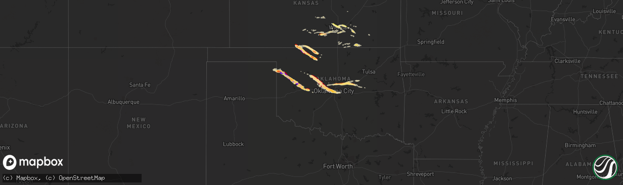
Hail Map in Oklahoma on April 22, 2013
The weather event in Oklahoma on April 22, 2013 includes Hail map. 3 states and 116 cities were impacted and suffered possible damage. The total estimated number of properties impacted is 16,940.
Want more than just the map?
Turn this storm into a full workflow.
- Owner + property data so you know who to knock
- OnDemand branded weather history reports to win the "did we even have hail?" argument
- RoofTrace estimate so reps stop guessing numbers at the door
Bought this map? Upgrade within 7 days and we'll credit the $230. (10-15 min setup call)
Hail
16,940
Estimated number of impacted properties by a 1.00" hail or larger209,714
Estimated number of impacted properties by a 1.75" hail or larger4,574
Estimated number of impacted properties by a 2.50" hail or largerStorm reports in Oklahoma
Oklahoma
| Date | Description |
|---|---|
| 04/22/20136:57 PM CDT | A local report indicates 1.25 inch wind near BURLINGTON |
| 04/22/20136:49 PM CDT | A local report indicates 1.25 inch wind near S BURLINGTON |
| 04/22/20136:44 PM CDT | A local report indicates 1.00 inch wind near 6 WNW BURLINGTON |
| 04/22/20136:44 PM CDT | A local report indicates 1.00 inch wind near 7 N ARNETT |
| 04/22/201312:06 AM CDT | The hail was reported at 1309 north meridian in oklahoma city. |
| 04/21/201311:48 PM CDT | A local report indicates 1.00 inch wind near 4 SE BETHANY |
| 04/21/201311:45 PM CDT | Hail was reported at the intersection of nw 38th terrace and riverside drive and lasted 10 minutes. |
| 04/21/201311:45 PM CDT | Hail was reported between meridian and macarthur blvd on nw 50th st. |
| 04/21/201311:45 PM CDT | The hail was reported at 1309 north meridian in oklahoma city. |
| 04/21/201311:35 PM CDT | A local report indicates 64 MPH wind near 15 W OKLAHOMA CITY |
| 04/21/201310:24 PM CDT | Relayed by em |
| 04/21/20139:30 PM CDT | A local report indicates 1.75 inch wind near 3 N BUTLER |
| 04/21/20138:45 PM CDT | A local report indicates 1.75 inch wind near 5 NE ANGORA |
| 04/21/20138:30 PM CDT | A local report indicates 2.50 inch wind near 5 SE LAMBERT |
| 04/21/20138:25 PM CDT | A local report indicates 1.00 inch wind near 8 S HARMON |
| 04/21/20138:21 PM CDT | A local report indicates 1.25 inch wind near 3 SW LAMBERT |
| 04/21/20137:50 PM CDT | A local report indicates 2.50 inch wind near 5 WSW ARNETT |
| 04/21/20137:33 PM CDT | A local report indicates 1.00 inch wind near 10 W ARNETT |
| 04/21/20137:04 PM CDT | A local report indicates 2.00 inch wind near 2 S DRIFTWOOD |
| 04/21/20137:00 PM CDT | A local report indicates 60 MPH wind near 16 NNE FREEDOM |
| 04/21/20137:00 PM CDT | A local report indicates 1.50 inch wind near BYRON |
Cities Impacted by Hail Map on April 22, 2013
- Hutchinson, KS
- South Hutchinson, KS
- Shattuck, OK
- Lipscomb, TX
- Higgins, TX
- Arnett, OK
- Clinton, OK
- Custer City, OK
- Arapaho, OK
- Maize, KS
- Coldwater, KS
- Alva, OK
- Latham, KS
- Helena, OK
- Carmen, OK
- Cherokee, OK
- Okarche, OK
- Cashion, OK
- Piedmont, OK
- Watonga, OK
- Oklahoma City, OK
- Bethany, OK
- Burlington, OK
- Hardtner, KS
- Kiowa, KS
- El Dorado, KS
- Omega, OK
- Kingfisher, OK
- Leedey, OK
- Butler, OK
- Cunningham, KS
- Spivey, KS
- Mulvane, KS
- Dacoma, OK
- Calumet, OK
- Geary, OK
- Arcadia, OK
- Edmond, OK
- Rose Hill, KS
- Norwich, KS
- Kingman, KS
- Goddard, KS
- Milton, KS
- Haysville, KS
- Clearwater, KS
- Peck, KS
- Viola, KS
- Wichita, KS
- Cheney, KS
- Hydro, OK
- Weatherford, OK
- Depew, OK
- Bristow, OK
- Seiling, OK
- Chandler, OK
- Davenport, OK
- Wellston, OK
- Luther, OK
- Benton, KS
- Colwich, KS
- Andover, KS
- Mount Hope, KS
- Augusta, KS
- Towanda, KS
- Okmulgee, OK
- Carney, OK
- Stroud, OK
- Jet, OK
- Stockton, KS
- El Reno, OK
- Yukon, OK
- Pratt, KS
- Piedmont, KS
- Leon, KS
- Derby, KS
- Maple City, KS
- Arkansas City, KS
- Garden Plain, KS
- Douglass, KS
- Lookeba, OK
- Hinton, OK
- Cedar Vale, KS
- Fredonia, KS
- Elk City, KS
- Longton, KS
- Dexter, KS
- Hitchcock, OK
- Canton, OK
- Choctaw, OK
- Oxford, KS
- Geuda Springs, KS
- South Haven, KS
- Woodston, KS
- Nash, OK
- Lake City, KS
- Winfield, KS
- Zenda, KS
- Castle, OK
- Okemah, OK
- Newalla, OK
- Logan, KS
- Lenora, KS
- Prairie View, KS
- Cambridge, KS
- Newkirk, OK
- Florence, KS
- Sedan, KS
- Atlanta, KS
- Burden, KS
- Goltry, OK
- Plevna, KS
- Sawyer, KS
- Isabel, KS
- Partridge, KS
- Abbyville, KS
- Guthrie, OK


