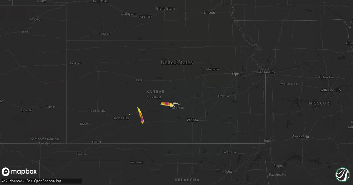
Hail Map in Kansas on April 19, 2020
Get this storm
April 19 map
$229
one time, instant access
Download today. No call, no setup
Keep the $229
Bought the map and want the full workflow? Apply the entire $229 to a subscription within 7 days. None of it is wasted.
Every map, not just this one
This buys you this map. Subscription and you get every map we run, in the markets you choose from a few cities to whole states to nationwide. Plus real-time alerts the moment a storm fires.
Contact data
Name, contact info, occupancy, even credit band for addresses in the footprint. You go from where it hit to who to call.
Become the source they trust
Unlimited branding weather history reports on demand. You already have the documented answer ready for the property owner, and you are the one who showed up with it.
Property data and RoofTrace estimates
Pull up any address you have got, its value and the exact code rules for that jurisdiction, straight from One Click Code. Then RoofTrace estimates the squares, pitch, and roof value, priced the way you price.
Storm reports in Kansas
Kansas
| Date | Description |
|---|---|
| 04/19/20206:41 PM CDT | A local report indicates 1.00 inch wind near 4 SSE STERLING |
| 04/19/20206:38 PM CDT | A local report indicates 1.50 inch wind near 4 S STERLING |
| 04/19/20206:30 PM CDT | A local report indicates 1.00 inch wind near 5 SSE ALDEN |
| 04/19/20203:45 PM CDT | Hail covering highway 50. |
| 04/19/20207:21 AM CDT | At 1220 AM CDT, a severe thunderstorm was located near Belvidere, moving northeast at 40 mph. HAZARD...Half dollar size hail. SOURCE...Radar indicated. IMPACT...Damage to vehicles is expected. Locations impacted include... Pratt, Haviland, Iuka, Sawyer, Cullison, Isabel, Coats, Byers, Wellsford and Croft. |
| 04/19/20201:53 AM CDT | At 653 PM CDT, a severe thunderstorm was located near Nickerson, moving southeast at 15 mph. HAZARD...60 mph wind gusts and quarter size hail. SOURCE...Radar indicated. IMPACT...Hail damage to vehicles is expected. Expect wind damage to roofs, siding, and trees. Locations impacted include... Hutchinson, South Hutchinson, Nickerson, Partridge and Willowbrook. |
| 04/19/20201:16 AM CDT | At 615 PM CDT, a severe thunderstorm was located 7 miles south of Alden, or 7 miles southwest of Sterling, moving east at 15 mph. HAZARD...60 mph wind gusts and quarter size hail. SOURCE...Radar indicated. IMPACT...Hail damage to vehicles is expected. Expect wind damage to roofs, siding, and trees. Locations impacted include... Sterling and Alden. |
| 04/18/202011:26 PM CDT | At 425 PM CDT, a severe thunderstorm was located near Fellsburg, moving south at 20 mph. HAZARD...60 mph wind gusts and half dollar size hail. SOURCE...Radar indicated. IMPACT...Hail damage to vehicles is expected. Expect wind damage to roofs, siding, and trees. Locations impacted include... Haviland.This new warning extends the previous warning which was in effect fornortheastern Kiowa County. |
| 04/18/202010:40 PM CDT | At 340 PM CDT, a severe thunderstorm was located near Lewis, moving southeast at 20 mph. HAZARD...60 mph wind gusts and quarter size hail. SOURCE...Radar indicated. IMPACT...Hail damage to vehicles is expected. Expect wind damage to roofs, siding, and trees. Locations impacted include... Lewis, Fellsburg, Centerview and Trousdale. |
All States Impacted by Hail Map on April 19, 2020
Cities Impacted by Hail Map on April 19, 2020
- Palestine, TX
- San Augustine, TX
- Shelbyville, TX
- Noble, LA
- Center, TX
- Terrell, TX
- Colmesneil, TX
- Woodville, TX
- Carthage, TX
- Converse, LA
- Joaquin, TX
- Mansfield, LA
- Grand Cane, LA
- Logansport, LA
- Lumberton, MS
- Purvis, MS
- Sumrall, MS
- Hattiesburg, MS
- Columbia, MS
- Ozark, AR
- Clarksville, AR
- Hartman, AR
- Grapeland, TX
- Desoto, TX
- Newton, MS
- Jesup, GA
- Saint Francisville, LA
- Detroit, TX
- Clarksville, TX
- Sterling, KS
- Alden, KS
- Houston, TX
- Tylertown, MS
- Nickerson, KS
- Brookston, TX
- Paris, TX
- Blackshear, GA
- Mineola, TX
- Van, TX
- Lindale, TX
- Grand Saline, TX
- Keatchie, LA
- Waco, TX
- McGregor, TX
- Woodway, TX
- Sumner, TX
- Roxton, TX
- Foxworth, MS
- Alexander City, AL
- Kellyton, AL
- Sunnyvale, TX
- Forney, TX
- Fort Towson, OK
- Hugo, OK
- Sawyer, OK
- Blossom, TX
- Deport, TX
- Pattonville, TX
- Nacogdoches, TX
- Katy, TX
- Brookshire, TX
- Cypress, TX
- Lake, MS
- Lawrence, MS
- Decatur, MS
- Conehatta, MS
- Forest, MS
- Douglass, TX
- Cushing, TX
- Rusk, TX
- Fairfield, TX
- Elkhart, TX
- Oakwood, TX
- Tennessee Colony, TX
- West Columbia, TX
- Lewis, KS
- Kinsley, KS
- Haviland, KS
- Ashland, LA
- Coushatta, LA
- Castor, LA
- Saline, LA
- Liberty, MS
- Warren, TX
- Grand Prairie, TX
- Arlington, TX
- Mansfield, TX
- Euless, TX
- Irving, TX
- Dallas, TX
- Fort Worth, TX
- Inman, KS
- Buhler, KS
- Hutchinson, KS
- Oark, AR
- Altus, AR
- Mccomb, MS
- Magnolia, MS
- Sandy Hook, MS
- Richton, MS
- Petal, MS
- New Augusta, MS
- Ozone, AR
- Livingston, TX
- Canton, TX
- Raymond, KS
- Mesquite, TX
- Garland, TX
- Clinton, LA
- Kaufman, TX
- Brookeland, TX
- Midlothian, TX
- Jasper, TX
- Irwinton, GA
- Valliant, OK
- Summit, MS
- Kokomo, MS
- Powderly, TX
- Kentwood, LA
- Franklinton, LA
- Osyka, MS
- Mount Hermon, LA
- Crandall, TX
- Milam, TX
- Equality, AL
- Greensburg, KS
- Garfield, KS
- Laneville, TX
- Reklaw, TX
- Alto, TX
- Boling, TX
- Rockwall, TX
- Wiergate, TX
- Mart, TX
- West Monroe, LA
- Jacksons Gap, AL
- Pledger, TX
- Damon, TX
- Hurst, TX
- Norwood, LA
- Wilson, LA
- Valdosta, GA
- Moody Afb, GA
- Lakeland, GA
- Lorena, TX
- Oglesby, TX
- Spring, TX
- Tomball, TX
- Montalba, TX
- Wharton, TX
- El Campo, TX
- Cedar Hill, TX
- Red Oak, TX
- Centreville, MS
- Hickory, MS
- Montezuma, GA
- Spearville, KS
- Seagoville, TX
- Wills Point, TX
- Ethelsville, AL
- Columbus, MS
- Spiro, OK
- Hudson, KS
- Sylvia, KS
- Annona, TX
- Avery, TX
- Cochran, GA
- Ringold, OK
- Duncanville, TX
- Toxey, AL
- Sealy, TX
- Bucklin, KS
- Huntington, TX
- Hemphill, TX
- Petty, TX
- Honey Grove, TX
- Lecompte, LA
- Groesbeck, TX
- Goodwater, AL
- Dadeville, AL
- Royse City, TX
- Morton, MS
- Pulaski, MS
- Union, MS
- Fulshear, TX
- Wallis, TX
- Quinlan, TX
- Buffalo, TX
- Sugar Land, TX
- Screven, GA
- Angleton, TX
- Hawkinsville, GA
- Hewitt, TX
- Riesel, TX
- Crawford, TX
- Hahira, GA
- Marshallville, GA
- Carrollton, AL
- Aledo, TX
- Greensburg, LA
- Seminary, MS
- Moselle, MS
- Zwolle, LA
- Shreveport, LA
- Rosharon, TX
- Ben Franklin, TX
- Garrison, TX
- Mount Enterprise, TX
- Raleigh, MS
- Rockford, AL
- Brookhaven, MS
- Parrott, GA
- Rufe, OK
- Teague, TX
- Mexia, TX
- Haltom City, TX
- Danbury, TX
- Freeport, TX
- Liverpool, TX
- Broaddus, TX
- Zavalla, TX
- Port Bolivar, TX
- Porter, TX
- Sweeny, TX
- Diboll, TX
- Etoile, TX
- Lufkin, TX
- Montgomery, LA
- Georgetown, LA
- Natchez, LA
- Dry Prong, LA
- Cloutierville, LA
- Atlanta, LA
- Melrose, LA
- Trout, LA
- Natchitoches, LA
- Colfax, LA
- Robeline, LA
- Provencal, LA
- Pollock, LA
- Leesville, LA
- Anacoco, LA
- Florien, LA
- Bentley, LA
- Jemison, AL
- Clanton, AL
- Weogufka, AL
- Randolph, AL
- Sylacauga, AL
- Maplesville, AL
- Thorsby, AL
- Shelby, AL
- Cuba, AL
- Lauderdale, MS
- York, AL
- Troy, AL
- New Brockton, AL
- Midland City, AL
- Ozark, AL
- Newville, AL
- Fort Rucker, AL
- Headland, AL
- Elba, AL
- Enterprise, AL
- Glenwood, AL
- Jack, AL
- Clio, AL
- Eufaula, AL
- Goshen, AL
- Dawson, GA
- Abbeville, AL
- Clayton, AL
- Louisville, AL
- Cuthbert, GA
- Shellman, GA
- Coleman, GA
- Fort Gaines, GA
- Brundidge, AL
- Ariton, AL
- Clopton, AL
- Morris, GA
- Bronwood, GA
- Leesburg, GA
- Albany, GA
- Sylvester, GA
- Columbia, AL
- Doerun, GA
- Crosby, MS
- Roxie, MS
- Meadville, MS
- Gloster, MS
- Woodville, MS
- Jackson, LA
- Fruitdale, AL
- Leakesville, MS
- Deer Park, AL
- State Line, MS
- Beaumont, MS
- McIntosh, AL
- Vinegar Bend, AL
- Neely, MS
- Tibbie, AL
- Redwood, MS
- Vicksburg, MS
- Hermanville, MS
- Port Gibson, MS
- Pattison, MS
- Lorman, MS
- Crystal Springs, MS
- Hazlehurst, MS
- Brandon, MS
- Enterprise, MS
- Rose Hill, MS
- Chunky, MS
- Louin, MS
- Meridian, MS
- Collinsville, MS
- Bailey, MS
- Daleville, MS
- Quitman, MS
- Stonewall, MS
- Du Pont, GA
- Naylor, GA
- Stockton, GA
- Montevallo, AL
- Calera, AL
- Reform, AL
- Cantonment, FL
- Pensacola, FL
- Milton, FL
- Eglin Afb, FL
- Holt, FL
- Brewton, AL
- Century, FL
- McDavid, FL
- Flomaton, AL
- Jay, FL
- Atmore, AL
- Bay Minette, AL
- Molino, FL
- Robertsdale, AL
- Loxley, AL
- Baker, FL
- Stapleton, AL
- Mobile, AL
- Crestview, FL
- Daphne, AL
- Fairhope, AL
- Theodore, AL
- Coden, AL
- Irvington, AL
- Grand Bay, AL
- Seminole, AL
- Lillian, AL
- Mary Esther, FL
- Elberta, AL
- Hurlburt Field, FL
- Fort Walton Beach, FL
- Gulf Breeze, FL
- Navarre, FL
- Ringgold, LA
- Mandeville, LA


