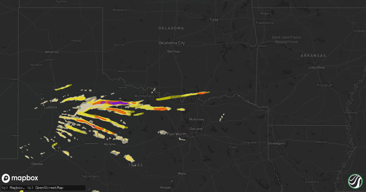
Hail Map on April 19, 2016
Get this storm
April 19 map
$229
one time, instant access
Download today. No call, no setup
Keep the $229
Bought the map and want the full workflow? Apply the entire $229 to a subscription within 7 days. None of it is wasted.
Every map, not just this one
This buys you this map. Subscription and you get every map we run, in the markets you choose from a few cities to whole states to nationwide. Plus real-time alerts the moment a storm fires.
Contact data
Name, contact info, occupancy, even credit band for addresses in the footprint. You go from where it hit to who to call.
Become the source they trust
Unlimited branding weather history reports on demand. You already have the documented answer ready for the property owner, and you are the one who showed up with it.
Property data and RoofTrace estimates
Pull up any address you have got, its value and the exact code rules for that jurisdiction, straight from One Click Code. Then RoofTrace estimates the squares, pitch, and roof value, priced the way you price.
Storm reports
Texas
| Date | Description |
|---|---|
| 04/19/20166:59 PM CDT | A local report indicates 1.00 inch wind near 4 E MABELLE |
| 04/19/20166:48 PM CDT | A local report indicates 1.50 inch wind near 14 N SANDERSON |
| 04/19/20166:35 PM CDT | West texas mesonet m61 mph wind gust. |
| 04/19/20165:50 PM CDT | Heavy rain and golf ball size hail highway 285 and gomez road 5 mile nw fort stockton |
| 04/19/20165:35 PM CDT | Public report of pingpong ball sized hail failing in truscott |
| 04/19/20164:50 PM CDT | Preliminary report of a tornado on the ground 8 to 10 minutes. No damage reported... Was in open country west of us hwy 285. |
| 04/19/20161:55 PM CDT | Fell at the hospital |
| 04/19/201612:32 AM CDT | Estimated winds up to 60 mph 3w of tioga... Tx. Small diameter tree limbs down. |
| 04/19/201612:10 AM CDT | Wind gusts 50 to 60 mph and nickel sized hail |
| 04/19/201612:10 AM CDT | 60 mph winds |
| 04/19/201612:10 AM CDT | Just east of i-35 in valley view |
| 04/19/201612:05 AM CDT | Numerous trees and power lines down near i-35 and fm922. Some trees on homes... Some blocking roads. Winds est 60 mph. |
| 04/18/201611:30 PM CDT | A local report indicates 60 MPH wind near FORESTBURG |
| 04/18/201611:30 PM CDT | Quarter sized hail |
| 04/18/201611:15 PM CDT | A local report indicates 1.75 inch wind near LUEDERS |
| 04/18/201611:08 PM CDT | Public reports 1.5 inch diameter hail just south of the city of bowie. |
| 04/18/201611:05 PM CDT | Wind-blown hail broke windows in a home |
| 04/18/201611:05 PM CDT | Quarter sized hail in bowie |
| 04/18/201610:25 PM CDT | Damaging thunderstorm winds uprooted a few large pecan and oak trees...broke off large tree branches and knocked over a fuel tank. A fuel pump was missing and the high |
| 04/18/201610:00 PM CDT | Quarter size hail reported near radium. |
| 04/18/20169:47 PM CDT | A local report indicates 2.00 inch wind near MENARD |
| 04/18/20169:38 PM CDT | Golfball size hail reported north of hamlin |
| 04/18/20169:35 PM CDT | A local report indicates 1.75 inch wind near 1 NE RULE |
| 04/18/20169:35 PM CDT | A local report indicates 1.00 inch wind near LAKE KICKAPOO |
| 04/18/20169:28 PM CDT | Quarter to half dollar size hail along us 190. |
| 04/18/20169:23 PM CDT | Wagon wheel dude ranch east of dermott. Very strong winds. |
| 04/18/20168:30 PM CDT | A local report indicates 1.00 inch wind near 2 S ACKERLY |
| 04/18/20168:18 PM CDT | On hwy 380. Some a little bigger than golf ball size. Time estimated from radar. |
| 04/18/20167:55 PM CDT | A local report indicates 1.00 inch wind near SANDERSON |
| 04/18/20167:51 PM CDT | Just west of sanderson on hwy 90. |
| 04/18/20167:40 PM CDT | Fell with strong wind gusts from north. No damage. |
Missouri
| Date | Description |
|---|---|
| 04/19/20166:20 PM CDT | Roof damage to a machine shed. Time estimated from radar. |
Oklahoma
| Date | Description |
|---|---|
| 04/18/201611:14 PM CDT | A local report indicates 1.75 inch wind near 3 S MEAD |
Cities Impacted by Hail Map on April 19, 2016
- Justiceburg, TX
- Big Spring, TX
- Menard, TX
- Anson, TX
- Aspermont, TX
- Hamlin, TX
- Rotan, TX
- Stamford, TX
- Albany, TX
- Lockney, TX
- Crosbyton, TX
- Ralls, TX
- Lenorah, TX
- Petrolia, TX
- Kingston, OK
- Durant, OK
- Calera, OK
- Mead, OK
- Goree, TX
- Seymour, TX
- Throckmorton, TX
- Munday, TX
- Knox City, TX
- Dryden, TX
- Fort Stockton, TX
- Cumby, TX
- Sulphur Springs, TX
- Afton, TX
- Imperial, TX
- Gail, TX
- Moran, TX
- Post, TX
- Crowell, TX
- Haskell, TX
- Fluvanna, TX
- Fort McKavett, TX
- Levelland, TX
- Shallowater, TX
- Snyder, TX
- Idalou, TX
- Floydada, TX
- Dickens, TX
- Spur, TX
- Abilene, TX
- Jayton, TX
- Lueders, TX
- Paducah, TX
- Stanton, TX
- Eldorado, TX
- Marietta, OK
- Whitesboro, TX
- Roaring Springs, TX
- Mcadoo, TX
- Lamesa, TX
- Windthorst, TX
- Sunset, TX
- Ackerly, TX
- Springlake, TX
- Tahoka, TX
- Holliday, TX
- Brady, TX
- Christoval, TX
- Lubbock, TX
- Weatherford, TX
- Henrietta, TX
- Bellevue, TX
- Montague, TX
- Archer City, TX
- Bowie, TX
- Forestburg, TX
- Scotland, TX
- Rule, TX
- Girard, TX
- Old Glory, TX
- Hawley, TX
- Valley View, TX
- Era, TX
- Gainesville, TX
- Andrews, TX
- Mansfield, TX
- Grand Prairie, TX
- Cedar Hill, TX
- Cisco, TX
- Weinert, TX
- Avoca, TX
- Baird, TX
- Wichita Falls, TX
- Lorenzo, TX
- Saint Jo, TX
- Newcastle, TX
- Benjamin, TX
- Caddo, OK
- Knott, TX
- Dallas, TX
- Abernathy, TX
- Goldsmith, TX
- Clyde, TX
- Tarzan, TX
- Sylvester, TX
- Roby, TX
- McCaulley, TX
- Coahoma, TX
- Lebanon, OK
- Olney, TX
- Merkel, TX
- Ovalo, TX
- Brashear, TX
- Byers, TX
- Millsap, TX
- Blanket, TX
- Burleson, TX
- Fort Worth, TX
- Kennedale, TX
- May, TX
- Cross Plains, TX
- Brownwood, TX
- Rising Star, TX
- Ringgold, TX
- Nocona, TX
- Burkett, TX
- Lawn, TX
- Cooper, TX
- Ira, TX
- Plainview, TX
- Woodson, TX
- Moody, TX
- Hermleigh, TX
- Hext, TX
- Loving, TX
- Bokchito, OK
- Burneyville, OK
- Leon, OK