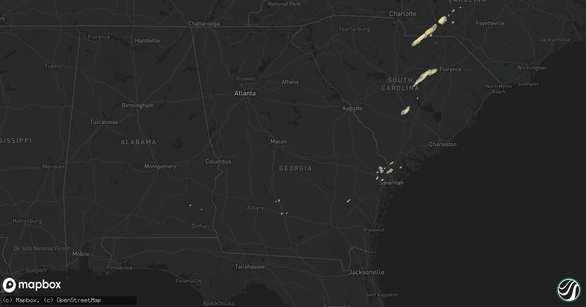
Hail Map in Georgia on April 19, 2013
Get this storm
April 19 map
$229
one time, instant access
Download today. No call, no setup
Keep the $229
Bought the map and want the full workflow? Apply the entire $229 to a subscription within 7 days. None of it is wasted.
Every map, not just this one
This buys you this map. Subscription and you get every map we run, in the markets you choose from a few cities to whole states to nationwide. Plus real-time alerts the moment a storm fires.
Contact data
Name, contact info, occupancy, even credit band for addresses in the footprint. You go from where it hit to who to call.
Become the source they trust
Unlimited branding weather history reports on demand. You already have the documented answer ready for the property owner, and you are the one who showed up with it.
Property data and RoofTrace estimates
Pull up any address you have got, its value and the exact code rules for that jurisdiction, straight from One Click Code. Then RoofTrace estimates the squares, pitch, and roof value, priced the way you price.
Storm reports in Georgia
Georgia
| Date | Description |
|---|---|
| 04/19/20133:58 PM CDT | Several trees blown down just northwest of ellabell. Time estimated based on radar. |
| 04/19/20133:47 PM CDT | Trees blown down on harmony church road. Time estimated based on radar. |
| 04/19/20133:43 PM CDT | Several trees down in stilson community. Time based on radar. |
| 04/19/20133:43 PM CDT | 2 trees down along highway 17 north. |
| 04/19/20133:24 PM CDT | Several trees down reported between 1800 and 2200 block of old rocky ford road. |
| 04/19/20132:53 PM CDT | Emergency manager reported power lines down in harlem. |
| 04/19/20132:51 PM CDT | Mcduffie county dispatch reported several trees down in dearing heading toward harlem. |
| 04/19/20131:10 PM CDT | Viewer reported to media that several trees were blown down along hwy 96 and hwy 358 in southern twiggs county. |
| 04/19/201312:50 PM CDT | A couple of trees were blown down in the bonaire area. |
| 04/19/201312:22 PM CDT | This tornado is the same tornado that moved from newton county. The tornado weakened as it moved into morgan county. Primarily tree damage occurred where several trees |
| 04/19/201312:12 PM CDT | *** 1 inj *** an ef2 tornado formed within a line of thunderstorms as it moved through newton county. Damage began along dukes road where trees were snapped and uproote |
| 04/19/201312:11 PM CDT | *** 1 inj *** apparant tornado hit mansfield...also observed clearly on atlanta tdwr radar. Final rating and determination pending damage survey. Six to eight homes wit |
| 04/19/201312:10 PM CDT | Several reports of damage...homes moved off their foundation...power poles down. |
| 04/19/201311:25 AM CDT | Wheat crops damaged. |
| 04/19/201310:35 AM CDT | Tree down on a home on 4900 block of wilcox way |
| 04/19/201310:30 AM CDT | A national weather service survey confirmed considerable damage due to a straight line wind event. Dozens of large oak trees were uprooted along a path from highway 280 |
| 04/19/201310:30 AM CDT | Trees down and uprooted with large limbs twisted off. One tree down through house and another on car. Glass blown out of circle-k store with part of roof down. One unco |
| 04/19/201310:30 AM CDT | A national weather service survey confirmed straight line wind damage with estimated winds of 80 to 90 mph resulting in dozens of trees down and uprooted with large lim |
All States Impacted by Hail Map on April 19, 2013
Cities Impacted by Hail Map on April 19, 2013
- Bullock, NC
- Prince George, VA
- Colonial Heights, VA
- Hopewell, VA
- Tifton, GA
- Boydton, VA
- Kenbridge, VA
- Buffalo Junction, VA
- Clarksville, VA
- Oxford, NC
- South Hill, VA
- Dundas, VA
- Alberta, VA
- Baskerville, VA
- Chase City, VA
- Dewitt, VA
- Rawlings, VA
- McKenney, VA
- Nelson, VA
- Blackstone, VA
- Petersburg, VA
- Disputanta, VA
- Church Road, VA
- Wilsons, VA
- Chester, VA
- Henrico, VA
- Brodnax, VA
- Dinwiddie, VA
- Chesterfield, VA
- Sutherland, VA
- Ford, VA
- Roxboro, NC
- Charles City, VA
- Fort Lee, VA
- Providence Forge, VA
- Pageland, SC
- Sumter, SC
- Bishopville, SC
- Burkeville, VA
- La Crosse, VA
- Doswell, VA
- Hanover, VA
- Ruther Glen, VA
- Ashland, VA
- Lamar, SC
- Bracey, VA
- Lexington, NC
- Randleman, NC
- Trinity, NC
- Asheboro, NC
- Sophia, NC
- Denton, NC
- High Point, NC
- Jamestown, NC
- Peachland, NC
- Polkton, NC
- Marshville, NC
- Elliott, SC
- Kershaw, SC
- Lancaster, SC
- Wadesboro, NC
- Ashburn, GA
- Lilesville, NC
- Mount Gilead, NC
- Orangeburg, SC
- New Smyrna Beach, FL
- Rowesville, SC
- Guyton, GA
- Branchville, SC
- Bowman, SC
- Cameron, SC
- Wedgefield, SC
- Shaw Afb, SC
- Abbeville, AL
- Green Bay, VA
- Dalzell, SC
- Ellerbe, NC
- Skipwith, VA
- Virgilina, VA
- Hardeeville, SC
- Rincon, GA
- Glen Allen, VA
- Springfield, GA
- Pooler, GA
- Bloomingdale, GA
- Lynch Station, VA
- Altavista, VA
- Halifax, VA
- South Boston, VA
- Scottsburg, VA
- Chesterfield, SC
- Mayesville, SC
- Rembert, SC
- Lynchburg, SC
- Okatie, SC
- Ridgeland, SC
- Jefferson, SC
- Heath Springs, SC
- Candor, NC
- Ariton, AL
- Columbia, VA
- Cartersville, VA
- Norlina, NC
- Dillwyn, VA
- Odum, GA
- Parma, ID
- Carthage, NC
- Forest, VA
- New Canton, VA
- Thomasville, NC
- Hampstead, MD
- Manchester, MD
- Tamaqua, PA
- Eagle Springs, NC
- Jackson Springs, NC
- Pinewood, SC
- Lawrenceville, VA
- Henderson, NC
- Milford, VA
- Mount Croghan, SC
- Timberlake, NC


