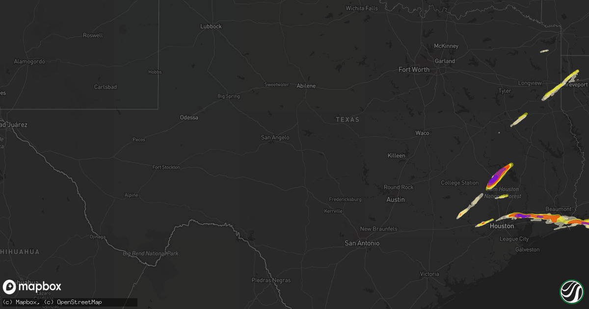
Hail Map in Texas on April 18, 2020
Get this storm
April 18 map
$229
one time, instant access
Download today. No call, no setup
Keep the $229
Bought the map and want the full workflow? Apply the entire $229 to a subscription within 7 days. None of it is wasted.
Every map, not just this one
This buys you this map. Subscription and you get every map we run, in the markets you choose from a few cities to whole states to nationwide. Plus real-time alerts the moment a storm fires.
Contact data
Name, contact info, occupancy, even credit band for addresses in the footprint. You go from where it hit to who to call.
Become the source they trust
Unlimited branding weather history reports on demand. You already have the documented answer ready for the property owner, and you are the one who showed up with it.
Property data and RoofTrace estimates
Pull up any address you have got, its value and the exact code rules for that jurisdiction, straight from One Click Code. Then RoofTrace estimates the squares, pitch, and roof value, priced the way you price.
Storm reports in Texas
Texas
| Date | Description |
|---|---|
| 04/18/20206:55 PM CDT | Estimated size through social media. |
| 04/18/20206:33 PM CDT | Report received via social media. |
| 04/18/20205:40 PM CDT | A local report indicates 1.75 inch wind near 2 S BELLVILLE |
| 04/18/20205:30 PM CDT | A local report indicates 1.75 inch wind near 2 S DAYTON |
| 04/18/20205:19 PM CDT | Hail fell for approximately 10 minutes with about 5 minutes of large stones. |
| 04/18/20205:19 PM CDT | A local report indicates 1.25 inch wind near 4 S ATASCOCITA |
| 04/18/20205:18 PM CDT | Marble to golfball size hail in the lake shadows and newport subdivisions near crosby. |
| 04/18/20205:06 PM CDT | Golfball hail near sebastopol. |
| 04/18/20205:00 PM CDT | A local report indicates 1.25 inch wind near 8 ENE RIVERSIDE |
| 04/18/20205:00 PM CDT | A local report indicates 3.00 inch wind near 6 ESE TRINITY |
| 04/18/20204:45 PM CDT | Golf ball size hail reported between huntsville and riverside. |
| 04/18/20204:45 PM CDT | A local report indicates 1.75 inch wind near 1 SE RIVERSIDE |
| 04/18/20204:35 PM CDT | Golfball hail for over a minute near fm 2929 and us 190. Facebook video appears to show even larger stones... But difficult to estimate size. |
| 04/18/20204:33 PM CDT | Facebook post with hail stone about the same size as an apple. |
| 04/18/20204:30 PM CDT | Golfball size hail reported just southeast of downtown huntsville. |
| 04/18/20204:30 PM CDT | Pictures sent to hgx email account. |
| 04/18/20204:24 PM CDT | Golfball size hail around elkins lake. |
| 04/18/20204:18 PM CDT | A local report indicates 1.25 inch wind near NEW WAVERLY |
| 04/18/20203:42 PM CDT | Dime to quarter size hail reported. |
| 04/18/20203:40 PM CDT | Penny to golfball size hail. |
| 04/18/20203:37 PM CDT | A local report indicates 1.50 inch wind near 3 E KATY |
| 04/18/20203:00 PM CDT | Corrects previous hail report from 2 s bellville for proper time of event. |
| 04/18/20203:05 AM CDT | At 805 PM CDT, a severe thunderstorm was located over Sacul, or 12 miles east of Rusk, moving northeast at 45 mph. HAZARD...Quarter size hail. SOURCE...Radar indicated. IMPACT...Damage to vehicles is expected. Locations impacted include... Sacul, Minden, Cushing, Mount Enterprise, Reklaw, Lawsonville, Glenfawn and Laneville. |
| 04/18/20202:28 AM CDT | At 728 PM CDT, a severe thunderstorm was located 11 miles northeast of Grapeland, or 17 miles southwest of Rusk, moving northeast at 45 mph. HAZARD...Quarter size hail. SOURCE...Radar indicated. IMPACT...Damage to vehicles is expected. Locations impacted include... Rusk, Alto, Morrill, Douglass, Reklaw, Linwood and Lilbert. |
| 04/18/202012:59 AM CDT | At 559 PM CDT, a severe thunderstorm was located 7 miles west of North Cleveland, or 8 miles west of Cleveland, moving east at 45 mph. HAZARD...Golf ball size hail and 60 mph wind gusts. SOURCE...Radar indicated. IMPACT...People and animals outdoors will be injured. Expect hail damage to roofs, siding, windows, and vehicles. Expect wind damage to roofs, siding, and trees. Locations impacted include... Cleveland, Cut And Shoot, North Cleveland and Tarkington Prairie. |
| 04/18/202012:50 AM CDT | At 549 PM CDT, a severe thunderstorm was located near Ames, or near Liberty, moving east at 30 mph. HAZARD...Golf ball size hail and 60 mph wind gusts. SOURCE...Radar indicated. IMPACT...People and animals outdoors will be injured. Expect hail damage to roofs, siding, windows, and vehicles. Expect wind damage to roofs, siding, and trees. Locations impacted include... Ames and Devers. |
| 04/18/202012:27 AM CDT | At 527 PM CDT, a severe thunderstorm was located 7 miles southwest of Dayton, moving east at 40 mph. HAZARD...Golf ball size hail and 60 mph wind gusts. SOURCE...Radar indicated. IMPACT...People and animals outdoors will be injured. Expect hail damage to roofs, siding, windows, and vehicles. Expect wind damage to roofs, siding, and trees. Locations impacted include... Southwestern Liberty, Dayton, Barrett, Crosby, northwestern Mont Belvieu and Sheldon. |
| 04/18/202012:18 AM CDT | At 517 PM CDT, a severe thunderstorm was located near Lake Houston, or near Kingwood, moving northeast at 25 mph. Storm is right on top of Lake Houston now. If on the lake, take immediate cover! HAZARD...Golf ball size hail and 60 mph wind gusts. SOURCE...Radar indicated. IMPACT...People and animals outdoors will be injured. Expect hail damage to roofs, siding, windows, and vehicles. Expect wind damage to roofs, siding, and trees. Locations impacted include... Western Liberty, Dayton, Kingwood, Splendora, Patton Village, Roman Forest, Woodbranch, Plum Grove, Lake Houston Dam, Lake Houston and Atascocita. |
| 04/17/202011:35 PM CDT | At 434 PM CDT, a severe thunderstorm was located near Huntsville State Park, or near Huntsville, moving northeast at 45 mph. HAZARD...Two inch hail and 60 mph wind gusts. SOURCE...Radar indicated. IMPACT...People and animals outdoors will be injured. Expect hail damage to roofs, siding, windows, and vehicles. Expect wind damage to roofs, siding, and trees. Locations impacted include... Onalaska, Point Blank, Riverside, Sebastopol and Oakhurst. |
| 04/17/202011:06 PM CDT | At 405 PM CDT, a severe thunderstorm was located near Montgomery, or 11 miles west of Willis, moving northeast at 40 mph. HAZARD...60 mph wind gusts and quarter size hail. SOURCE...Radar indicated. IMPACT...Hail damage to vehicles is expected. Expect wind damage to roofs, siding, and trees. Locations impacted include... Huntsville, Willis, New Waverly, Montgomery, Huntsville State Park and Dacus. |
| 04/17/202010:54 PM CDT | At 354 PM CDT, a severe thunderstorm was located over Jersey Village, moving east at 35 mph. HAZARD...60 mph wind gusts and quarter size hail. SOURCE...Radar indicated. IMPACT...Hail damage to vehicles is expected. Expect wind damage to roofs, siding, and trees. Locations impacted include... Jersey Village, Addicks Park Ten, Spring Branch North, Greater Greenspoint, northwestern Northside / Northline, Spring Branch West, Aldine, Westbranch, Langwood, Fairbanks / Northwest Crossing, Willowbrook, Hidden Valley, Acres Home, Greater Inwood, Carverdale, Spring Branch Central, Central Northwest and Independence Heights. |
| 04/17/202010:40 PM CDT | At 340 PM CDT, a severe thunderstorm was located near Todd Mission, or 11 miles northwest of Pinehurst, moving northeast at 45 mph. HAZARD...60 mph wind gusts and quarter size hail. SOURCE...Radar indicated. IMPACT...Hail damage to vehicles is expected. Expect wind damage to roofs, siding, and trees. Locations impacted include... Todd Mission, Plantersville and Dobbin. |
| 04/17/202010:35 PM CDT | At 335 PM CDT, a severe thunderstorm was located over Katy, moving northeast at 20 mph. HAZARD...60 mph wind gusts and quarter size hail. SOURCE...Radar indicated. IMPACT...Hail damage to vehicles is expected. Expect wind damage to roofs, siding, and trees. Locations impacted include... Katy and southwestern Addicks Park Ten. |
| 04/17/20208:12 PM CDT | 1 inch hail reported at plant nursery nickel to quarter size hail. |
All States Impacted by Hail Map on April 18, 2020
Cities Impacted by Hail Map on April 18, 2020
- Clanton, AL
- Rockford, AL
- Sylacauga, AL
- Goodwater, AL
- Weogufka, AL
- Kellyton, AL
- Shelby, AL
- Gueydan, LA
- Kaplan, LA
- Greenwood, LA
- Waskom, TX
- Beckville, TX
- De Berry, TX
- Marshall, TX
- Shreveport, LA
- Shaw, MS
- Pickens, MS
- Rolling Fork, MS
- Goodman, MS
- Lake Providence, LA
- Carthage, MS
- Vaughan, MS
- Cary, MS
- Camden, MS
- Kosciusko, MS
- Benton, MS
- Yazoo City, MS
- Sallis, MS
- Boyle, MS
- Jeanerette, LA
- Donaldsonville, LA
- Geismar, LA
- Gonzales, LA
- Haviland, KS
- Mullinville, KS
- New Iberia, LA
- Loranger, LA
- Husser, LA
- Trinity, TX
- Meade, KS
- El Dorado, AR
- Smackover, AR
- Pierre Part, LA
- Morgan City, LA
- Plantersville, TX
- Waller, TX
- Navasota, TX
- Hempstead, TX
- Louin, MS
- Raleigh, MS
- Woodville, MS
- Cat Spring, TX
- Chappell Hill, TX
- Bellville, TX
- Cameron, LA
- Huntsville, TX
- New Waverly, TX
- Greenwood, MS
- Holcomb, MS
- Schlater, MS
- Beaumont, TX
- Devers, TX
- Carrollton, MS
- Cushing, TX
- Erath, LA
- Delcambre, LA
- Abbeville, LA
- Fosters, AL
- Emerson, AR
- Louann, AR
- Magnolia, AR
- Mount Holly, AR
- Benton, LA
- Franklin, LA
- Napoleonville, LA
- Baldwin, LA
- Millport, AL
- Thorsby, AL
- Maplesville, AL
- Plaquemine, LA
- Montgomery, TX
- Groveton, TX
- Oakhurst, TX
- Pointblank, TX
- Eutaw, AL
- Saint Francisville, LA
- Batchelor, LA
- Plaucheville, LA
- Simmesport, LA
- Lettsworth, LA
- Melville, LA
- Angola, LA
- Creole, LA
- Bell City, LA
- Moundville, AL
- Akron, AL
- Grand Chenier, LA
- White Castle, LA
- Saint Amant, LA
- Philadelphia, MS
- Noxapater, MS
- Houston, TX
- Dayton, TX
- Liberty, TX
- Humble, TX
- Crosby, TX
- Katy, TX
- Greensburg, KS
- Sun City, KS
- Coats, KS
- Port Arthur, TX
- Grenada, MS
- Palmetto, LA
- Atlanta, TX
- Linden, TX
- West Point, MS
- Aurora, NC
- Eupora, MS
- Mendenhall, MS
- Magee, MS
- Pinola, MS
- Forest, MS
- Winnie, TX
- Plains, KS
- Scooba, MS
- Macon, MS
- Brookshire, TX
- Hamshire, TX
- Haynesville, LA
- Shongaloo, LA
- Cleveland, TX
- Conroe, TX
- Calera, AL
- Jemison, AL
- Montevallo, AL
- Brierfield, AL
- Randolph, AL
- Louisville, MS
- Denham Springs, LA
- Baton Rouge, LA
- Amite, LA
- Saint Martinville, LA
- Carrollton, AL
- Addis, LA
- Alexander City, AL
- Ethelsville, AL
- Knoxville, AL
- Hampton, AR
- Daviston, AL
- Bossier City, LA
- Carthage, TX
- Duck Hill, MS
- Minneola, KS
- Drew, MS
- Willis, TX
- Preston, MS
- Alto, TX
- Rusk, TX
- Hankamer, TX
- Blanchard, LA
- Prairieville, LA
- Douglassville, TX
- Labadieville, LA
- Cleveland, MS
- Sealy, TX
- Grapeland, TX
- Haughton, LA
- Belle Rose, LA
- Anahuac, TX
- Wallisville, TX
- Groves, TX
- Lake Arthur, LA
- Doddsville, MS
- Starkville, MS
- Lafayette, AL
- Roanoke, AL
- Wadley, AL
- Five Points, AL
- Hogansville, GA
- Sunflower, MS
- Centreville, AL
- Columbiana, AL
- Newhebron, MS
- Newton, MS
- De Kalb, MS
- Watson, OK
- Ralph, AL
- Huffman, TX
- Mount Enterprise, TX
- Laneville, TX
- Holly Bluff, MS
- Mayersville, MS
- Pioneer, LA
- Camden, NC
- South Mills, NC
- Shawboro, NC
- Moyock, NC
- Elizabeth City, NC
- Shiloh, NC
- Frisco, NC
- Hatteras, NC
- Buxton, NC
- Avon, NC


