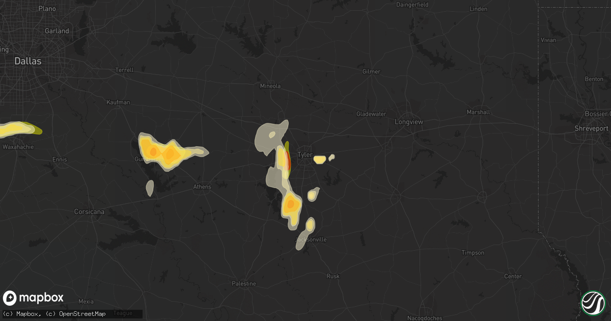
Hail Map in Tyler, TX on April 18, 2015
Get this storm
April 18 map
$229
one time, instant access
Download today. No call, no setup
Keep the $229
Bought the map and want the full workflow? Apply the entire $229 to a subscription within 7 days. None of it is wasted.
Every map, not just this one
This buys you this map. Subscription and you get every map we run, in the markets you choose from a few cities to whole states to nationwide. Plus real-time alerts the moment a storm fires.
Contact data
Name, contact info, occupancy, even credit band for addresses in the footprint. You go from where it hit to who to call.
Become the source they trust
Unlimited branding weather history reports on demand. You already have the documented answer ready for the property owner, and you are the one who showed up with it.
Property data and RoofTrace estimates
Pull up any address you have got, its value and the exact code rules for that jurisdiction, straight from One Click Code. Then RoofTrace estimates the squares, pitch, and roof value, priced the way you price.
Storm reports in Tyler, TX
Tyler, TX
| Date | Description |
|---|---|
| 04/17/201510:39 PM CDT | Trees down on the west side of tyler. |
| 04/17/20159:36 PM CDT | Golfball size hail estimated on the west side of tyler pounds field airport. |
| 04/17/20159:34 PM CDT | Sheriff office reports numerous trees down along greenbriar rd. |
All States Impacted by Hail Map on April 18, 2015
All Cities Impacted by Hail Map on April 18, 2015
- San Saba, TX
- Lometa, TX
- Fairview, OK
- Amorita, OK
- Milan, KS
- Argonia, KS
- Buchanan Dam, TX
- Llano, TX
- Mankato, KS
- Electra, TX
- Wakita, OK
- Perrin, TX
- Poolville, TX
- Millsap, TX
- Graford, TX
- Weatherford, TX
- Mineral Wells, TX
- Bullard, TX
- Tyler, TX
- Blanchard, OK
- Bogue, KS
- Fredericksburg, TX
- Healdton, OK
- Wilson, OK
- Fort Hood, TX
- Brownwood, TX
- Mabank, TX
- Paint Rock, TX
- Great Bend, KS
- Junction, TX
- Kearney, NE
- Riverdale, NE
- Grand River, IA
- Decatur, IA
- Leon, IA
- Van Wert, IA
- Flower Mound, TX
- Roanoke, TX
- Clinton, OK
- Corn, OK
- Valentine, NE
- Chester, OK
- Ennis, TX
- Italy, TX
- Barry, TX
- Corsicana, TX
- Blooming Grove, TX
- Sylvan Grove, KS
- Doss, TX
- San Angelo, TX
- Seymour, TX
- Holliday, TX
- Newcastle, TX
- Colony, OK
- Hydro, OK
- Cordell, OK
- Lipan, TX
- Jacksonville, TX
- Decatur, TX
- London, TX
- Menard, TX
- Indiahoma, OK
- Snyder, OK
- Roosevelt, OK
- Mountain View, OK
- Mountain Park, OK
- Kerrville, TX
- Blanco, TX
- Davidson, OK
- Hunter, OK
- Garber, OK
- Altus, OK
- Blair, OK
- Headrick, OK
- Lone Wolf, OK
- Hobart, OK
- Buffalo, OK
- Wilmore, KS
- Haviland, KS
- Sun City, KS
- Coldwater, KS
- Iuka, KS
- Dripping Springs, TX
- Maize, KS
- Valley Center, KS
- Austin, TX
- Driftwood, TX
- Richland Springs, TX
- Kemp, TX
- Athens, TX
- Eustace, TX
- Saint Jo, TX
- St John, KS
- Stafford, KS
- Valley Spring, TX
- Kerens, TX
- Nash, OK
- Flint, TX
- Chandler, TX
- Coleman, TX
- Cross Plains, TX
- Burkett, TX
- Chatfield, TX
- Rice, TX
- Vici, OK
- Itasca, TX
- Grandview, TX
- Waynoka, OK
- Mooreland, OK
- Azle, TX
- Damar, KS
- Palco, KS
- Woodson, TX
- Eden, TX
- Melvin, TX
- Boerne, TX
- Cleburne, TX
- Rio Vista, TX
- Mason, TX
- Brownsboro, TX
- Millersview, TX
- Lohn, TX
- Bangs, TX
- Gouldbusk, TX
- Doole, TX
- Santa Anna, TX
- Spicewood, TX
- Round Mountain, TX
- Castell, TX
- Eldorado, TX
- Purdum, NE
- Albany, TX
- Minden, NE
- Sedgwick, KS
- Palo Pinto, TX
- Pleasanton, NE
- South Haven, KS
- Wellington, KS
- Concordia, KS
- Johnson City, TX
- Leander, TX
- Frederick, OK
- Breckenridge, TX
- Carmen, OK
- Brady, TX
- Throckmorton, TX
- Stonewall, OK
- Hollister, OK
- Bronson, KS
- Erick, OK
- Sayre, OK
- Comfort, TX
- Freedom, OK
- Mayfield, KS
- Oxford, KS
- Anthony, KS
- Winfield, KS
- Burlington, OK
- Rock, KS
- Belle Plaine, KS
- Bluff City, KS
- Udall, KS
- Caldwell, KS
- Manchester, OK
- Medford, OK
- Barnard, KS
- Whitehouse, TX
- Alva, OK
- Cherokee, OK
- McCook, NE
- Willow City, TX
- Harper, TX
- Art, TX
- Phillipsburg, KS
- Goldthwaite, TX
- Caddo, TX
- Abilene, TX
- Newcastle, OK
- Brady, NE
- Waxahachie, TX
- Marietta, OK
- Graham, TX
- Strawn, TX
- Pratt, KS
- Macksville, KS
- Byers, KS
- Ellsworth, KS
- Muenster, TX
- Red Level, AL
- Andalusia, AL
- Cedar, KS
- Gaylord, KS
- Belpre, KS
- Forestburg, TX
- Noble, OK
- Grandfield, OK
- Elk City, OK
- Sweetwater, OK
- Cheyenne, OK
- Hext, TX
- Rocky, OK
- Gotebo, OK
- Morganville, KS
- Coalgate, OK
- Centrahoma, OK
- Tuttle, OK
- Lenora, KS
- Lodgepole, NE
- Crook, CO
- De Leon, TX
- Taloga, OK
- Burwell, NE
- Thedford, NE
- Wimberley, TX
- Coppell, TX
- Plainville, KS
- Midlothian, TX
- Venus, TX
- Palmer, TX
- Red Oak, TX
- Alvarado, TX
- Sonora, TX
- Kaufman, TX
- Wood River, NE
- Sterling, KS
- Abbyville, KS
- Hays, KS
- Jet, OK
- Helena, OK
- Douglass, KS
- Mulvane, KS
- Freeport, KS
- Waldron, KS
- Harrold, TX
- Colwich, KS
- Ellis, KS
- South Bend, TX
- Butler, OK
- Wilsonville, NE
- Macomb, OK
- Wanette, OK
- Gordon, TX
- Arnett, OK
- Chambers, NE
- Amherst, NE
- Loveland, OK
- Protection, KS
- Holdenville, OK
- Comanche, TX
- Justin, TX
- Fort Worth, TX
- Gainesville, TX
- Hye, TX
- Killeen, TX
- Boelus, NE
- Shelbyville, TX
- Springtown, TX
- Ben Wheeler, TX
- Dallas, TX
- Fort Scott, KS
- Stephenville, TX
- Walnut Springs, TX
- Bluff Dale, TX
- Hawley, TX
- Aline, OK
- Kenesaw, NE
- Mullinville, KS
- Bucklin, KS
- Kiowa, KS
- Arp, TX
- Christoval, TX
- Ada, OK
- Bandera, TX
- Chickasha, OK
- Plevna, KS
- Vancourt, TX
- May, TX
- Glade, KS
- Overton, TX
- Henderson, TX
- Norman, OK
- Mutual, OK
- Laredo, TX
- Encinal, TX
- Sidney, TX
- Duncan, OK
- Hico, TX
- Goodland, KS
- Foss, OK
- Harper, KS
- Danville, KS
- Kempner, TX
- Winnfield, LA
- Dill City, OK
- Selman City, TX
- Brewton, AL
- Evergreen, AL
- Santo, TX
- Joshua, TX
- Lawton, OK
- Dacoma, OK
- Allen, TX
- Hazelton, KS
- Ringling, OK
- Juniata, NE
- Mcloud, OK
- Newalla, OK
- Gordonville, TX
- Clyde, KS
- Forreston, TX
- Prescott, KS
- Hudson, KS
- Lookeba, OK
- Sylvia, KS
- Lincoln, KS
- Grand Island, NE
- Alda, NE
- Oberlin, KS
- Derby, KS
- Haysville, KS
- Larue, TX
- San Marcos, TX
- Manor, TX
- Lott, TX
- Murchison, TX
- Shattuck, OK
- Purcell, OK
- Anson, TX
- Amber, OK
- Cotulla, TX
- Holstein, NE
- Paradise, TX
- Robeline, LA
- Bend, TX
- Elgin, TX
- Rhome, TX
- Cambridge, NE
- Merkel, TX
- Ingleside, TX
- Aransas Pass, TX
- Port Aransas, TX
- Belton, TX
- Temple, TX
- Edson, KS
- Shelton, NE
- Tipton, OK
- Aledo, TX
- Stonewall, LA
- Mansfield, TX
- Cedar Hill, TX
- Aurora, KS
- Troup, TX
- Seiling, OK
- Alton, KS
- Portis, KS
- Arapaho, OK
- Longdale, OK
- Palestine, TX
- Elkhart, TX
- Washington, OK
- Minneola, KS
- Norton, KS
- Coushatta, LA
- Watonga, OK
- Greenfield, OK
- Geary, OK
- Arlington, TX
- Grand Prairie, TX
- Terrell, TX
- Milford, TX
- Many, LA
- Converse, LA
- Catharine, KS
- Hammon, OK
- Rochelle, TX
- The Colony, TX
- Calvin, OK
- Moody, TX
- Gatesville, TX
- Carnegie, OK
- Wills Point, TX
- Kingston, OK
- Lebanon, OK
- Ponder, TX
- Krum, TX
- Copperas Cove, TX
- Lewisville, TX
- Trinidad, TX
- Clifton, KS
- Lindale, TX
- Frierson, LA
- Cleo Springs, OK
- Elmore City, OK
- Granbury, TX
- Tolar, TX
- Ranger, TX
- Marlin, TX
- Kirwin, KS
- Stockton, KS
- Luther, OK
- Burneyville, OK
- Davis City, IA
- Davis, OK
- Eola, TX
- Wall, TX
- Olney, TX
- Sentinel, OK
- Weatherford, OK
- Heartwell, NE
- Burr Oak, KS
- Esbon, KS
- Ayr, NE
- Hastings, NE
- Inland, NE
- Red Cloud, NE
- Lebanon, KS
- Lake Dallas, TX
- Alba, TX
- Yantis, TX
- Atlanta, KS


