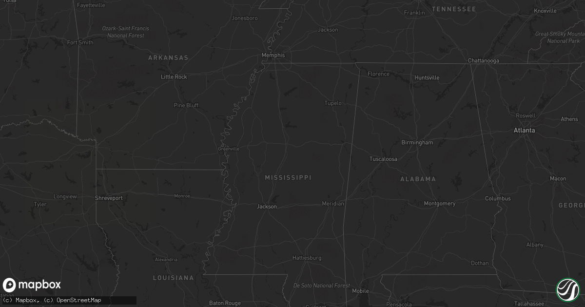
Hail Map in Missouri on April 18, 2011
Get this storm
April 18 map
$229
one time, instant access
Download today. No call, no setup
Keep the $229
Bought the map and want the full workflow? Apply the entire $229 to a subscription within 7 days. None of it is wasted.
Every map, not just this one
This buys you this map. Subscription and you get every map we run, in the markets you choose from a few cities to whole states to nationwide. Plus real-time alerts the moment a storm fires.
Contact data
Name, contact info, occupancy, even credit band for addresses in the footprint. You go from where it hit to who to call.
Become the source they trust
Unlimited branding weather history reports on demand. You already have the documented answer ready for the property owner, and you are the one who showed up with it.
Property data and RoofTrace estimates
Pull up any address you have got, its value and the exact code rules for that jurisdiction, straight from One Click Code. Then RoofTrace estimates the squares, pitch, and roof value, priced the way you price.
Storm reports in Missouri
Missouri
| Date | Description |
|---|---|
| 04/18/20116:58 AM CDT | Largest hailstone was 1.75 inches. Pea size hail also occurred. |
| 04/18/20116:50 AM CDT | A local report indicates 1.00 inch wind near SPANISH LAKE |
| 04/18/20116:46 AM CDT | A local report indicates 1.75 inch wind near FERGUSON |
| 04/18/20116:44 AM CDT | A local report indicates 1.50 inch wind near OVERLAND |
| 04/18/20116:43 AM CDT | A local report indicates 1.00 inch wind near 1 WNW JENNINGS |
| 04/18/20116:40 AM CDT | A local report indicates 1.00 inch wind near ST. CHARLES |
| 04/18/20116:39 AM CDT | 2 reports of 1 inch hail from this area |
| 04/18/20116:38 AM CDT | A local report indicates 1.75 inch wind near HERCULANEUM |
| 04/18/20116:36 AM CDT | A local report indicates 1.00 inch wind near CRYSTAL CITY |
| 04/18/20116:32 AM CDT | A local report indicates 2.75 inch wind near PEVELY |
| 04/18/20116:32 AM CDT | Update to report....2 cars lost windshields at sandcastle off highway z. |
| 04/18/20116:31 AM CDT | A local report indicates 1.75 inch wind near HERCULANEUM |
| 04/18/20116:30 AM CDT | A local report indicates 1.00 inch wind near FESTUS |
| 04/18/20116:29 AM CDT | Windshield knocked out of a car. |
| 04/18/20116:29 AM CDT | A local report indicates 1.75 inch wind near HILLSBORO |
| 04/18/20116:27 AM CDT | At jefferson college. |
| 04/18/20116:24 AM CDT | One window was broken by the hail. |
| 04/18/20116:23 AM CDT | Started at 618 am and continues....ground covered. |
| 04/18/20116:21 AM CDT | At ladue and olive. |
| 04/18/20116:20 AM CDT | A local report indicates 1.00 inch wind near 3 NW HILLSBORO |
| 04/18/20116:13 AM CDT | Lasted 3 minutes from 609 to 612 am. Quarter to golf ball size hail. |
| 04/18/20116:08 AM CDT | Lasted 3 minutes...from 0605 to 0608 am. |
| 04/18/20116:03 AM CDT | A local report indicates 1.00 inch wind near LONEDELL |
| 04/18/20115:38 AM CDT | A local report indicates 1.75 inch wind near DUTZOW |
| 04/18/20115:32 AM CDT | On highway 100. |
| 04/18/20115:27 AM CDT | Spotter network....on highway 185 includes gusts to 20 mph. |
| 04/18/20115:18 AM CDT | Also includes gusts to 20 mph. |
| 04/18/20115:17 AM CDT | A local report indicates 1.00 inch wind near WASHINGTON |
| 04/18/20115:10 AM CDT | Nickel to quarter size hail. |
| 04/18/20115:01 AM CDT | A local report indicates 1.00 inch wind near 2 NW HERMANN |
| 04/18/20114:55 AM CDT | A local report indicates 1.75 inch wind near 2 N KINGDOM CITY |
| 04/18/20114:55 AM CDT | A local report indicates 1.00 inch wind near PERSHING |
| 04/18/20114:50 AM CDT | Emergency management estimated nickel to quarter sized hail southeast of the rolla national airport. |
| 04/18/20114:05 AM CDT | A local report indicates 1.00 inch wind near 2 SSW HOLTS SUMMIT |
| 04/18/20113:55 AM CDT | A local report indicates 1.00 inch wind near 2 SE BURLINGTON JCT |
| 04/18/20113:50 AM CDT | At 507 crest dr. 315 am hail began... Lasted 10 min then ended. Began again 10 min later...max hail was 1.25 inches |
| 04/18/20113:50 AM CDT | A local report indicates 1.75 inch wind near 4 NW JEFFERSON CITY |
| 04/18/20113:48 AM CDT | A local report indicates 1.00 inch wind near NEW BLOOMFIELD |
| 04/18/20113:40 AM CDT | Law enforcement reported large tree over county road 419 near junction with state highway z. |
| 04/18/20113:34 AM CDT | West side of jefferson city. Deck is covered. |
| 04/18/20113:21 AM CDT | A local report indicates 1.75 inch wind near JEFFERSON CITY |
| 04/18/20113:18 AM CDT | A local report indicates 1.00 inch wind near 3 ESE ST. MARTINS |
| 04/18/20113:13 AM CDT | A local report indicates 1.00 inch wind near LOHMAN |
| 04/18/20113:00 AM CDT | Law enforcement reported large tree down over highway m east of eldon. |
| 04/18/20112:40 AM CDT | Ky3 relayed a public report of quarter size hail between laurie and gravois mills |
| 04/18/20112:40 AM CDT | Camden county dispatch reports quarter size hail on lake road 530. |
| 04/18/201112:00 AM CDT | Average size 1.00 inch diameter. |
All States Impacted by Hail Map on April 18, 2011
Cities Impacted by Hail Map on April 18, 2011
- Fayette, MO
- Alexandria, NE
- Dittmer, MO
- Grubville, MO
- Luebbering, MO
- Lonedell, MO
- Bloomfield, KY
- Chesterfield, MO
- Saint Louis, MO
- Ballwin, MO
- Earth City, MO
- Hazelwood, MO
- Saint Ann, MO
- Granite City, IL
- Florissant, MO
- Saint Charles, MO
- Saint Peters, MO
- Bridgeton, MO
- Maryland Heights, MO
- Edwardsville, IL
- Promise City, IA
- Carlisle, KY
- Ewing, KY
- Murrayville, IL
- Carleton, NE
- Lake Ozark, MO
- Rocky Mount, MO
- Eldon, MO
- Barnhart, MO
- Pevely, MO
- Hillsboro, MO
- Russellville, MO
- Hartsburg, MO
- New Bloomfield, MO
- Holts Summit, MO
- Eugene, MO
- Olean, MO
- Lohman, MO
- Jefferson City, MO
- Tebbetts, MO
- Morrison, MO
- Fellsmere, FL
- Barnett, MO
- Lincoln, NE
- Vienna, MO
- Saint James, MO
- Meredosia, IL
- Chapin, IL
- Winchester, IL
- Jacksonville, IL
- Bluffs, IL
- Griggsville, IL
- Pittsfield, IL
- Arenzville, IL
- Concord, IL
- Walton, KY
- Bowling Green, MO
- Eolia, MO
- Clarksville, MO
- Moore Haven, FL
- Lake Placid, FL
- Venus, FL
- Fairfax, MO
- Union Star, MO
- King City, MO
- Mound City, MO
- Maitland, MO
- Skidmore, MO
- Crete, NE
- Wilber, NE
- Edina, MO
- Novelty, MO
- Berger, MO
- Chamois, MO
- Rhineland, MO
- Bonnots Mill, MO
- Fulton, MO
- Mokane, MO
- Portland, MO
- Hermann, MO
- White Hall, IL
- Hillview, IL
- Virginia, IL
- Middletown, MO
- Pleasant Hill, IL
- Louisiana, MO
- Curryville, MO
- Nebo, IL
- Franklin, IL
- Pearl, IL
- Rockport, IL
- Roodhouse, IL
- Kampsville, IL
- New Haven, MO
- Ohiowa, NE
- Geneva, NE
- Strang, NE
- Milligan, NE
- Leslie, MO
- Gerald, MO
- Beaufort, MO
- Cedar Hill, MO
- Cuba, MO
- Columbia, IL
- Valmeyer, IL
- Leasburg, MO
- Herculaneum, MO
- Imperial, MO
- Festus, MO
- Bourbon, MO
- Sullivan, MO
- De Soto, MO
- Saint Clair, MO
- Waterloo, IL
- Mexico, MO
- Mount Ayr, IA
- Diagonal, IA
- Bethany, MO
- Fort Meade, FL
- Sunrise Beach, MO
- Camdenton, MO
- Auxvasse, MO
- Williamsburg, MO
- Aurora, NE
- Alexander, IL
- Ashland, IL
- Freeburg, MO
- Marthasville, MO
- Steedman, MO
- Independence, KY
- Morning View, KY
- Verona, KY
- Perry, MO
- Henderson, WV
- Gallipolis Ferry, WV
- Apple Grove, WV
- Southside, WV
- Point Pleasant, WV
- Swanton, NE
- Washington, MO
- Milford, NE
- Pleasant Dale, NE
- Loxahatchee, FL
- West Palm Beach, FL
- Shelbina, MO
- Maryville, MO
- Graham, MO
- Frankford, MO
- New London, MO
- Tuscumbia, MO
- Centertown, MO
- Kingdom City, MO
- Thompson, MO
- Columbia, MO
- Ashland, MO
- Labelle, FL
- West Alton, MO
- Portage Des Sioux, MO
- Stover, MO
- Sebring, FL
- Harrisburg, MO
- Latham, MO
- Clarksburg, MO
- Malcolm, NE
- Albany, MO
- Clewiston, FL
- New Franklin, MO
- Franklin, MO
- Benton City, MO
- Laddonia, MO
- Farber, MO
- Rush Hill, MO
- New Hampton, MO
- Martinsville, MO
- Henley, MO
- Henderson, NE
- Warrenton, MO
- Linn, MO
- Ravenwood, MO
- Melbourne, KY
- New Richmond, OH
- Wellsville, MO
- Crothersville, IN
- Bland, MO
- Mount Sterling, MO
- Owensville, MO
- Center, MO
- Monroe City, MO
- Hallsville, MO
- Martinsburg, MO
- Centralia, MO
- Santa Fe, MO
- Belle, MO
- New Salem, IL
- Flemingsburg, KY
- Conception Junction, MO
- House Springs, MO
- Amelia, OH
- Foristell, MO
- Defiance, MO
- Augusta, MO
- Villa Ridge, MO
- Rosebud, MO
- Labadie, MO
- Cole Camp, MO
- Jamestown, MO
- York, NE
- Waco, NE
- Otterville, MO
- Florence, MO
- Kenesaw, NE
- Heartwell, NE
- Alexandria, KY
- Crittenden, KY
- Vanceburg, KY
- Garrison, KY
- California, MO
- Mount Orab, OH
- Fayetteville, OH
- Williamsburg, OH
- Minden, NE
- Gravois Mills, MO
- Roach, MO
- Bedford, IA
- Blockton, IA
- Burlington Junction, MO
- Hopkins, MO
- Clearmont, MO
- Batavia, OH
- Pacific, MO
- Robertsville, MO
- Catawissa, MO
- Tingley, IA
- Ellston, IA
- Vero Beach, FL
- Benton, IA
- Denton, NE
- Georgetown, OH
- Stanberry, MO
- Darlington, MO
- New Canton, IL
- Sardinia, OH
- Winchester, OH
- Brownsville, IN
- Centerville, IN
- Pickering, MO
- Brock, NE
- Talmage, NE
- Miami, FL
- Tarkio, MO
- Indiantown, FL
- Savannah, MO
- Ulman, MO
- Brumley, MO
- Ochopee, FL
- Fort Pierce, FL
- Climax Springs, MO
- Nemaha, NE
- Guilford, MO
- Argyle, MO
- Saronville, NE
- Giltner, NE
- Harvard, NE
- Sutton, NE
- Cross Timbers, MO
- Eureka, MO
- Patriot, IN
- Warsaw, KY
- South Bay, FL
- Meta, MO
- Chambersburg, IL
- Baylis, IL
- Bardstown, KY
- Madison, IN
- Commiskey, IN
- Dupont, IN
- Versailles, MO
- Montgomery City, MO
- Oolitic, IN
- Bedford, IN
- Hampton, NE
- Fenton, MO
- High Ridge, MO
- Stella, NE
- Humboldt, NE
- Bunceton, MO
- Syracuse, MO
- Vichy, MO
- Latonia, KY
- Craig, MO
- Corydon, IA
- Brinktown, MO
- Dixon, MO
- Barnard, MO
- Glencoe, KY
- Union, KY
- Sparta, KY
- Sanders, KY
- Ghent, KY
- Barry, IL
- Rea, MO
- Wallingford, KY
- Wymore, NE
- Blue Springs, NE
- Tipton, MO
- Vandalia, MO
- Filley, NE
- Arnold, MO
- Richwoods, MO
- Bethel, OH
- Smithton, MO
- Carrollton, KY
- Wood River, IL
- Bethalto, IL
- Wright City, MO
- East Carondelet, IL
- Dupo, IL
- East Saint Louis, IL
- Wildwood, MO
- O'Fallon, MO
- Valley Park, MO
- Wentzville, MO
- Lake Saint Louis, MO
- Deshler, NE
- Millstadt, IL
- North Vernon, IN
- Deputy, IN
- Paris Crossing, IN
- Seaman, OH
- Lincoln, MO
- Paris, MO
- Belle Glade, FL
- Waverly, IL


