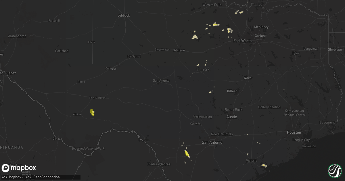
Hail Map in Texas on April 17, 2017
Get this storm
April 17 map
$229
one time, instant access
Download today. No call, no setup
Keep the $229
Bought the map and want the full workflow? Apply the entire $229 to a subscription within 7 days. None of it is wasted.
Every map, not just this one
This buys you this map. Subscription and you get every map we run, in the markets you choose from a few cities to whole states to nationwide. Plus real-time alerts the moment a storm fires.
Contact data
Name, contact info, occupancy, even credit band for addresses in the footprint. You go from where it hit to who to call.
Become the source they trust
Unlimited branding weather history reports on demand. You already have the documented answer ready for the property owner, and you are the one who showed up with it.
Property data and RoofTrace estimates
Pull up any address you have got, its value and the exact code rules for that jurisdiction, straight from One Click Code. Then RoofTrace estimates the squares, pitch, and roof value, priced the way you price.
Storm reports in Texas
Texas
| Date | Description |
|---|---|
| 04/17/20176:45 PM CDT | A local report indicates 1.50 inch wind near 20 E ZAPATA |
| 04/17/20176:45 PM CDT | Storm spotter repoted quarter size hail in falfurrias. |
| 04/17/201712:35 PM CDT | Delayed report: quarter to half dollar size hail reported in jermyn |
| 04/17/20179:16 AM CDT | Delayed report... Large living tree snapped above ground & took down power pole & lines at orange & brockett... Sherman |
| 04/16/20178:00 PM CDT | Nws skywarn spotter reported quarter size hail in encino. |
All States Impacted by Hail Map on April 17, 2017
Cities Impacted by Hail Map on April 17, 2017
- Marathon, TX
- Encino, TX
- Sarita, TX
- Falfurrias, TX
- Riviera, TX
- Selfridge, ND
- Loving, TX
- San Saba, TX
- Lometa, TX
- Jermyn, TX
- Bryson, TX
- Eagle Butte, SD
- Vicksburg, MS
- Mission, TX
- Leesville, LA
- Burwell, NE
- Weatherford, TX
- Dyersburg, TN
- Crystal City, TX
- Jacksboro, TX
- McIntosh, SD
- Strasburg, ND
- Rockwood, TN
- Grandview, TN
- Elk Point, SD
- Keldron, SD
- Lemmon, SD
- Zapata, TX
- Edinburg, TX
- Rio Grande City, TX
- San Diego, TX
- Concepcion, TX
- Howes, SD
- Zachary, LA
- Knippa, TX
- Dodson, LA
- Hebbronville, TX
- Erwinville, LA
- Port Allen, LA
- Jonesboro, LA
- Perrin, TX
- Burbank, SD
- Beresford, SD
- Meadow, SD
- Brownwood, TX
- May, TX
- Poolville, TX
- Bridgeport, TX
- Newcastle, TX
- Graham, TX
- Woodson, TX
- Watauga, SD
- Morristown, SD
- Centerville, TX
- Newport, NE
- Muenster, TX
- Sledge, MS
- Lake Charles, LA
- Marietta, OK
- Sidney, TX
- Comanche, TX
- Laredo, TX
- Fort Stockton, TX
- Santa Anna, TX
- Saint Jo, TX
- Faith, SD
- Paradise, TX
- Springtown, TX
- Midland, SD
- Port Lavaca, TX
- Lolita, TX
- Gainesville, TX
- Duncan, MS
- Batesville, TX
- Pearsall, TX
- Sabinal, TX
- Fort Pierre, SD
- Clarksdale, MS
- Sondheimer, LA
- Valentine, NE
- Walsh, CO
- Hallettsville, TX
- Smithville, TN
- Hayes, SD
- Albany, TX
- Breckenridge, TX
- Cherry Creek, SD
- Roma, TX
- Ainsworth, NE
- Flatonia, TX
- Dilley, TX
- Pineville, LA
- Bassett, NE
- Stuart, NE
- Milesville, SD
- Coahoma, MS
- White Owl, SD
- Amite, LA
- Independence, LA
- San Ygnacio, TX
- Johnstown, NE
- Cuero, TX
- Enid, MS
- Kenton, TN
- Tunica, MS
- Charleston, MS
- Mathis, TX
- Schlater, MS
- Trezevant, TN
- Atwood, TN
- Selmer, TN
- Clayton, NM
- Lawton, OK
- Fletcher, OK
- Guerra, TX
- De Leon, TX
- Gorman, TX
- Lyon, MS
- Sublime, TX
- Mora, LA
- Marks, MS
- Duck River, TN
- Reva, SD
- Vermillion, SD
- Matagorda, TX


