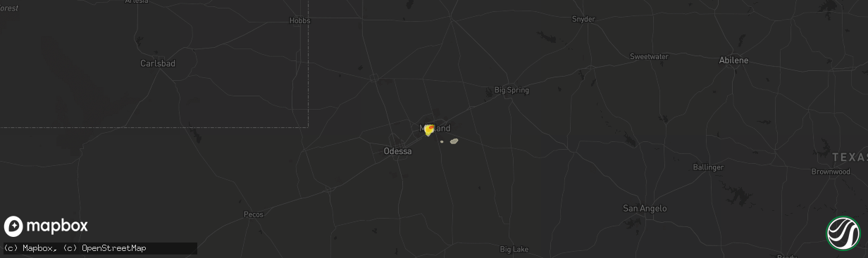
Hail Map in Midland, TX on April 16, 2017
The weather event in Midland, TX on April 16, 2017 includes Hail map. 11 states and 257 cities were impacted and suffered possible damage. The total estimated number of properties impacted is 13,123.
Hail
13,123
Estimated number of impacted properties by a 1.00" hail or larger1,955
Estimated number of impacted properties by a 1.75" hail or larger0
Estimated number of impacted properties by a 2.50" hail or largerStorm reports in Midland, TX
Midland, TX
| Date | Description |
|---|---|
| 04/16/20176:40 PM CDT | Wall st and midkiff rd. |
| 04/16/20176:35 PM CDT | Between midkiff rd and garfield rd. Two blocks n of golf course rd. |
| 04/16/20176:32 PM CDT | Quarter size hail for 10 minutes at louisiana street and g street in midland. |
| 04/16/20176:30 PM CDT | 3 blocks nw of midland memorial hospital. |
| 04/16/20176:27 PM CDT | Midland dr and wadley dr. |
| 04/16/20176:25 PM CDT | Hail occurred at cuthbert and bedford in midland. |
| 04/16/20176:21 PM CDT | Largest 1 1/8 inch. |
| 04/16/20176:20 PM CDT | A local report indicates 1.00 inch wind near MIDLAND |
All States Impacted by Hail Map on April 16, 2017
All Cities Impacted by Hail Map on April 16, 2017
- Carrizo Springs, TX
- Laredo, TX
- Quitaque, TX
- Clarendon, TX
- Silverton, TX
- Leakey, TX
- Rio Frio, TX
- Uvalde, TX
- Arnett, OK
- Falls Of Rough, KY
- Reynolds Station, KY
- Cloverport, KY
- Fordsville, KY
- Hardinsburg, KY
- Goldsmith, TX
- Sonora, TX
- Brackettville, TX
- Stamford, TX
- Midland, TX
- Post, TX
- Rush Springs, OK
- Battletown, KY
- Mauckport, IN
- Union Star, KY
- Stephensport, KY
- Webster, KY
- Rome, IN
- Cannelton, IN
- Lockney, TX
- Panhandle, TX
- Groom, TX
- Claude, TX
- Eagle Pass, TX
- Carbondale, IL
- Marion, IL
- South West City, MO
- Grove, OK
- Mount Vernon, IN
- Iowa Park, TX
- Chester, OK
- Mutual, OK
- Big Cabin, OK
- Vinita, OK
- Pampa, TX
- Ekron, KY
- Brandenburg, KY
- Vine Grove, KY
- Abernathy, TX
- Shallowater, TX
- Waurika, OK
- Ryan, OK
- Alpine, TX
- Miles, TX
- Kress, TX
- Fairland, OK
- Afton, OK
- Petty, TX
- Groveton, TX
- Mereta, TX
- Paint Rock, TX
- Eola, TX
- San Angelo, TX
- Noel, MO
- Anderson, MO
- Tulia, TX
- Lakeview, TX
- Canadian, TX
- Seiling, OK
- Wayne, OK
- Byars, OK
- Haskell, TX
- Fort Stockton, TX
- Wyandotte, OK
- Childress, TX
- Seminole, TX
- San Ygnacio, TX
- Bartlesville, OK
- Ochelata, OK
- Irvington, KY
- Derby, IN
- Elizabeth, IN
- Guston, KY
- Laconia, IN
- Payneville, KY
- Rhodelia, KY
- Crystal City, TX
- Zapata, TX
- Brownfield, TX
- Kremlin, OK
- Enid, OK
- Uniontown, KY
- Evansville, IN
- Henderson, KY
- Kermit, TX
- Perryton, TX
- Big Wells, TX
- Rocksprings, TX
- Pawhuska, OK
- Canton, OK
- Trinchera, CO
- Roosevelt, TX
- Purcell, OK
- Forestburg, TX
- Muenster, TX
- Fredonia, KY
- Princeton, KY
- Weatherford, OK
- Realitos, TX
- Lanagan, MO
- Bluejacket, OK
- Braman, OK
- South Haven, KS
- Chickasha, OK
- Ninnekah, OK
- Cement, OK
- Big Lake, TX
- Barksdale, TX
- Cheyenne, OK
- Odessa, TX
- Oilton, TX
- Mirando City, TX
- La Pryor, TX
- Bruni, TX
- Leedey, OK
- Midkiff, TX
- Springlake, TX
- Amarillo, TX
- El Indio, TX
- Mertzon, TX
- Taylorsville, KY
- Hebbronville, TX
- Canyon, TX
- Happy, TX
- Eucha, OK
- Quemado, TX
- Plainview, TX
- Hale Center, TX
- Shidler, OK
- Marathon, TX
- Tahoka, TX
- Batesville, TX
- Decatur, AR
- Gravette, AR
- Meadow, TX
- Lufkin, TX
- Huntington, TX
- Burbank, OK
- Strang, OK
- Dryden, TX
- Corrigan, TX
- Crawford, OK
- Andrews, TX
- Welch, OK
- Diboll, TX
- Hawesville, KY
- Haxtun, CO
- Greenville, MO
- Wichita Falls, TX
- Raton, NM
- Kaw City, OK
- Anson, TX
- Eddyville, KY
- Rule, TX
- Ringling, OK
- Zavalla, TX
- Paoli, OK
- Nowata, OK
- Amanda, OH
- Clubb, MO
- Mannford, OK
- Metropolis, IL
- La Center, KY
- Kevil, KY
- Barlow, KY
- Wickliffe, KY
- Batavia, OH
- Cincinnati, OH
- Comstock, TX
- Comanche, OK
- Moscow, TX
- Neosho, MO
- Jennings, OK
- Coalgate, OK
- Ramona, OK
- Fort Towson, OK
- Junction, TX
- Barnsdall, OK
- Wagoner, OK
- Hulbert, OK
- Rowena, TX
- Fort Davis, TX
- Durham, OK
- Saint Jo, TX
- Stanton, TX
- Seneca, MO
- Slaton, TX
- Wilson, TX
- Springer, NM
- Vici, OK
- Mount Carmel, IL
- Mooreland, OK
- Stella, MO
- Rockbridge, OH
- Laurelville, OH
- Nash, OK
- Ropesville, TX
- Levelland, TX
- Indiahoma, OK
- Maysville, OK
- Sherman, TX
- Elberfeld, IN
- Talala, OK
- Newkirk, OK
- Rocky Comfort, MO
- Exeter, MO
- Drumright, OK
- Calhoun, KY
- Holliday, TX
- Brookston, TX
- Ballinger, TX
- Concepcion, TX
- Jay, OK
- Christoval, TX
- Yale, OK
- Stillwater, OK
- Ripley, OK
- Cushing, OK
- Wilson, OK
- Wynona, OK
- Milford, OH
- Fairview, OK
- Barnhart, TX
- Duncan, OK
- Fort Gibson, OK
- Tulsa, OK
- Medina, TX
- Fieldton, TX
- Grandfalls, TX
- Lorenzo, TX
- Odonnell, TX
- Waddy, KY
- Mount Eden, KY
- Shepherdsville, KY
- West Point, KY
- Conroe, TX
- Eldorado, TX
- Taloga, OK
- Tell, TX
- Paris, TX
- Littlefield, TX
- Menard, TX
- Harned, KY
- Perry, OK
- Scammon, KS
- Notrees, TX
- Spearman, TX
- Petersburg, TX


