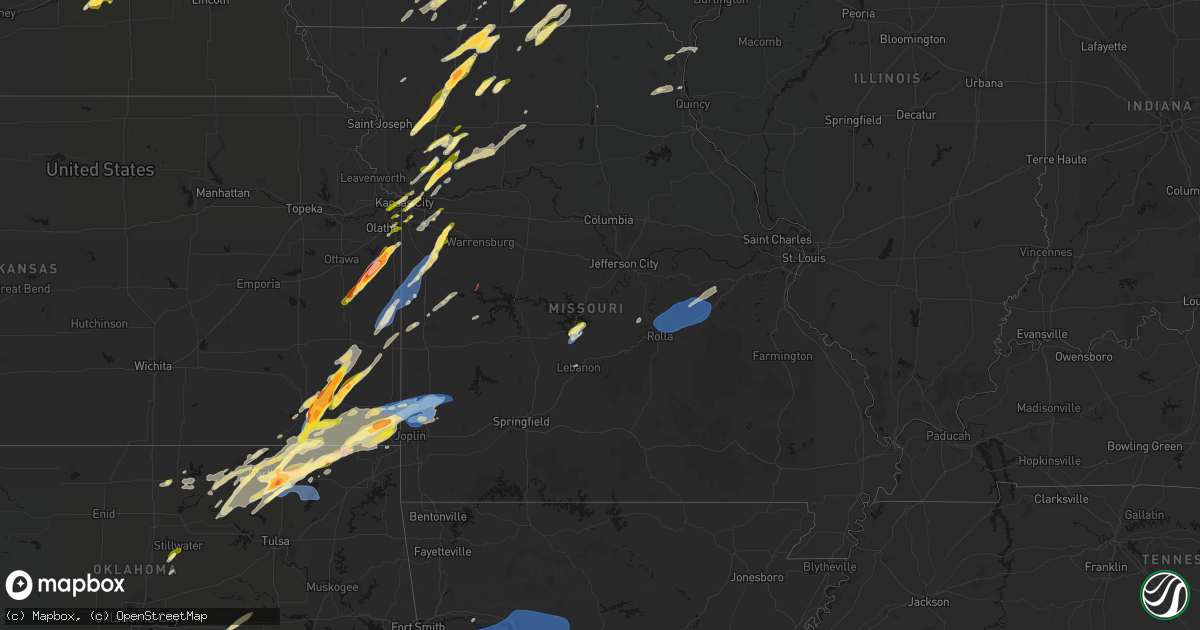
Hail Map in Missouri on April 15, 2026
Get this storm
April 15 map
$229
one time, instant access
Download today. No call, no setup
Keep the $229
Bought the map and want the full workflow? Apply the entire $229 to a subscription within 7 days. None of it is wasted.
Every map, not just this one
This buys you this map. Subscription and you get every map we run, in the markets you choose from a few cities to whole states to nationwide. Plus real-time alerts the moment a storm fires.
Contact data
Name, contact info, occupancy, even credit band for addresses in the footprint. You go from where it hit to who to call.
Become the source they trust
Unlimited branding weather history reports on demand. You already have the documented answer ready for the property owner, and you are the one who showed up with it.
Property data and RoofTrace estimates
Pull up any address you have got, its value and the exact code rules for that jurisdiction, straight from One Click Code. Then RoofTrace estimates the squares, pitch, and roof value, priced the way you price.
Storm reports in Missouri
Missouri
| Date | Description |
|---|---|
| 04/15/20266:48 PM CDT | Public/social media report... Time estimated from radar. |
| 04/15/20266:44 PM CDT | Large limbs down... Estimated 60 mph wind gusts. Time estimated from radar. |
| 04/15/20266:23 PM CDT | Social media report. Time estimated from radar. |
| 04/15/20266:13 PM CDT | Metal roofing of building torn off. Time estimated from radar. |
| 04/15/20266:09 PM CDT | Tornado reported on the ground by storm chaser. |
| 04/15/20265:59 PM CDT | Taken from social media... Video of bent power poles and shingles blown off house. Time estimated by radar. |
| 04/15/20265:58 PM CDT | A local report indicates 1.25 inch wind near 2 S Kingston |
| 04/15/20265:47 PM CDT | Report from mping: half dollar |
| 04/15/20265:45 PM CDT | Social media report. Time confirmed from radar. |
| 04/15/20265:44 PM CDT | A local report indicates 1.25 inch wind near 2 NW Knoxville |
| 04/15/20265:41 PM CDT | Taken from social media. Time estimated by radar. |
| 04/15/20265:39 PM CDT | Large tree downed at a residence. Time estimated from radar. |
| 04/15/20265:35 PM CDT | Social media report. Time estimated from radar. |
| 04/15/20265:30 PM CDT | Social media report. Time estimated from radar. |
| 04/15/20265:29 PM CDT | Downed wires near mica lane. Time estimated from radar. |
| 04/15/20265:28 PM CDT | Damaged pole and downed wires south of excelsior springs. Time estimated from radar. |
| 04/15/20265:26 PM CDT | Report from mping: quarter |
| 04/15/20265:20 PM CDT | Report from mping: quarter |
| 04/15/20265:20 PM CDT | Half dollar sized hail reported at crowder state park. |
| 04/15/20265:19 PM CDT | Downed tree limbs and wires near highland avenue. Time estimated from radar. |
| 04/15/20265:13 PM CDT | Social media report. Time estimated from radar. |
| 04/15/20265:10 PM CDT | Time estimated from radar. |
| 04/15/20265:07 PM CDT | Downed wires near foxwood drive. Time estimated from radar. |
| 04/15/20265:07 PM CDT | Large tree uprooted and house and siding damage from wind-driven hail at a residence near lone jack. Time estimated from radar. |
| 04/15/20265:07 PM CDT | Social media report. Time estimated from radar. |
| 04/15/20265:07 PM CDT | Downed tree limbs and wires near falk drive. Time estimated from radar. |
| 04/15/20265:07 PM CDT | Downed tree limbs and wires near park avenue. Time estimated from radar. |
| 04/15/20265:06 PM CDT | Video from social media shows estimated quarter sized hail. Time taken from social media and confirmed by radar. |
| 04/15/20265:04 PM CDT | Several social media reports of hail up to golf ball size east of bethany. Time estimated from radar. |
| 04/15/20265:02 PM CDT | Social media report of quarter size hail in the strasburg area. Time estimated from radar. |
| 04/15/20265:00 PM CDT | Taken from social media... Estimated ping pongs. Time estimated from radar. |
| 04/15/20264:56 PM CDT | Social media report. Time estimated from radar. |
| 04/15/20264:53 PM CDT | Social media report. Time estimated from radar. |
| 04/15/20264:53 PM CDT | Social media report. Time estimated from radar. |
| 04/15/20264:52 PM CDT | Em passed along report of estimated 3 inch hail from deputy. Time estimated from radar. |
| 04/15/20264:50 PM CDT | Social media report. Time estimated from radar. |
| 04/15/20264:50 PM CDT | Social media report with photo of broken windshield. Time estimated from radar. |
| 04/15/20264:48 PM CDT | Photo relayed via social media. |
| 04/15/20264:47 PM CDT | Taken from social media... Time estimated from radar. |
| 04/15/20264:47 PM CDT | Social media report. Time estimated from radar. |
| 04/15/20264:47 PM CDT | *** 1 inj *** vehicular accident was caused by the hail with one injury. Time estimated from radar. |
| 04/15/20264:29 PM CDT | Social media report. Time estimated from radar. |
| 04/15/20264:29 PM CDT | Social media report and photos. Time estimated from radar. |
| 04/15/20264:26 PM CDT | Social media report. Time estimated from radar. |
| 04/15/20264:26 PM CDT | Report relayed via social media. Time estimated from radar. |
| 04/15/20264:22 PM CDT | Time estimated from radar. |
| 04/15/20264:20 PM CDT | Report from social media. Time estimated from radar. |
| 04/15/20264:19 PM CDT | Social media report and video of ping pong ball size hail northwest of cameron. Time estimated from radar. |
| 04/15/20264:17 PM CDT | A local report indicates 1.00 inch wind near 1 NW Kearney |
| 04/15/20264:13 PM CDT | Social media report and video. Time estimated from radar. |
| 04/14/20269:35 PM CDT | Tree over the roadway. |
| 04/14/20269:26 PM CDT | A local report indicates 59 MPH wind near Oronogo |
| 04/14/20269:22 PM CDT | Thunderstorm winds downed a large tree over state highway 126 west of i-49. |
| 04/14/20268:50 PM CDT | Large tree down. |
| 04/14/20268:42 PM CDT | Thunderstorm winds downed a tree into the roadway. |
| 04/14/20268:40 PM CDT | A tree fell into the roadway on y highway northwest of rolla. |
| 04/14/20268:15 PM CDT | Large downed tree blocking entire road. |
| 04/14/20267:43 PM CDT | Quarter size hail. |
| 04/14/20267:38 PM CDT | Roof damage at the building near the airport. No additional info at this time. |
| 04/14/20267:35 PM CDT | Large tree down and other large limbs down. |
| 04/14/20267:19 PM CDT | Social media report. Time estimated from radar. |
All States Impacted by Hail Map on April 15, 2026
Cities Impacted by Hail Map on April 15, 2026
- Genoa, NE
- Kingston, OK
- Monroe, NE
- Saybrook, IL
- Columbus, NE
- Bellwood, NE
- Schuyler, NE
- Leigh, NE
- David City, NE
- Rogers, NE
- Clarkson, NE
- Dodge, NE
- Howells, NE
- North Bend, NE
- Ames, NE
- Hooper, NE
- Scribner, NE
- Tekamah, NE
- Craig, NE
- Herman, NE
- Winslow, NE
- Nashoba, OK
- Little Sioux, IA
- Mondamin, IA
- Arlington, NE
- Pisgah, IA
- Logan, IA
- Woodbine, IA
- Moorhead, IA
- Dunlap, IA
- Dow City, IA
- Earling, IA
- Onawa, IA
- West Point, NE
- Denison, IA
- Arion, IA
- Defiance, IA
- Charter Oak, IA
- Ute, IA
- Soldier, IA
- Manilla, IA
- Westside, IA
- Vail, IA
- Deloit, IA
- Aspinwall, IA
- Manning, IA
- Arcadia, IA
- Breda, IA
- Kiron, IA
- Halbur, IA
- Carroll, IA
- Templeton, IA
- Hampton, NE
- Aurora, NE
- Giltner, NE
- Harvard, NE
- Irwin, IA
- Glidden, IA
- Henderson, NE
- Rochester, IN
- Kewanna, IN
- Scranton, IA
- Ralston, IA
- Churdan, IA
- Jefferson, IA
- Silver Lake, IN
- Claypool, IN
- Akron, IN
- Warsaw, IN
- Pierceton, IN
- Coon Rapids, IA
- Dedham, IA
- Waco, NE
- York, NE
- Mentone, IN
- Utica, NE
- Staplehurst, NE
- Gresham, NE
- Paton, IA
- Ulysses, NE
- Seward, NE
- Dwight, NE
- Bee, NE
- Winona Lake, IN
- Bradshaw, NE
- Roann, IN
- Macy, IN
- Brainard, NE
- Valparaiso, NE
- Dana, IA
- Weston, NE
- Rome City, IN
- Kendallville, IN
- Hudson, IN
- Corunna, IN
- Wolcottville, IN
- Stratford, IA
- Stanhope, IA
- North Manchester, IN
- Liberty Mills, IN
- Churubusco, IN
- Huntertown, IN
- Fort Wayne, IN
- Ashley, IN
- Pleasant Lake, IN
- Wahoo, NE
- Malmo, NE
- Ceresco, NE
- Boone, IA
- Ames, IA
- Story City, IA
- Gilbert, IA
- Jewell, IA
- Colon, NE
- Roland, IA
- Randall, IA
- Mark Center, OH
- Sherwood, OH
- Hicksville, OH
- Antwerp, OH
- Cecil, OH
- Mead, NE
- Graham, TX
- Grabill, IN
- Edgerton, OH
- Dewey, OK
- Bartlesville, OK
- Radcliffe, IA
- Alden, IA
- Ellsworth, IA
- Olney, TX
- Newcastle, TX
- Auburn, IN
- Leo, IN
- Spencerville, IN
- Blissfield, MI
- Riga, MI
- Ottawa Lake, MI
- Ida, MI
- Petersburg, MI
- Saint Joe, IN
- Harlan, IN
- McCallsburg, IA
- Yutan, NE
- Fremont, NE
- Valley, NE
- Defiance, OH
- Barnsdall, OK
- Ochelata, OK
- Ramona, OK
- Iowa Falls, IA
- Skiatook, OK
- Wann, OK
- New Haven, IN
- Copan, OK
- Holgate, OH
- Coffeyville, KS
- Dearing, KS
- Ackley, IA
- Aplington, IA
- Hominy, OK
- Archbold, OH
- Bryan, OH
- Stryker, OH
- Ney, OH
- Evansport, OH
- Napoleon, OH
- Liberty, KS
- Hubbard, IA
- Zearing, IA
- Independence, KS
- Cherryvale, KS
- Malinta, OH
- Dennis, KS
- Parsons, KS
- Galesburg, KS
- Thayer, KS
- Union, IA
- New Providence, IA
- Nowata, OK
- Austinville, IA
- Hamler, OH
- Conrad, IA
- Erie, KS
- Beaman, IA
- Stuart, IA
- Huxley, IA
- Cambridge, IA
- Merkel, TX
- Eldora, IA
- Whitten, IA
- Liscomb, IA
- Blair, NE
- Kennard, NE
- Slater, IA
- Delaware, OK
- Leipsic, OH
- Polk City, IA
- Parkersburg, IA
- Custar, OH
- Cygnet, OH
- Rudolph, OH
- Martin, OH
- Haskins, OH
- Dunbridge, OH
- Bowling Green, OH
- Pemberville, OH
- Woodville, OH
- Stony Ridge, OH
- New Bavaria, OH
- Bradner, OH
- Liberty Center, OH
- Risingsun, OH
- Walbridge, OH
- Gibsonburg, OH
- Wayne, OH
- Portage, OH
- Helena, OH
- Weston, OH
- Luckey, OH
- McClure, OH
- Tontogany, OH
- Elmore, OH
- Grelton, OH
- Deshler, OH
- Perrysburg, OH
- Genoa, OH
- Clay Center, OH
- Millbury, OH
- Waterville, OH
- Graytown, OH
- Milton Center, OH
- Grand Rapids, OH
- Chanute, KS
- Dexter, IA
- Missouri Valley, IA
- Lenapah, OK
- Grafton, OH
- North Ridgeville, OH
- Elyria, OH
- Lagrange, OH
- Columbia Station, OH
- Saint Paul, KS
- Hoytville, OH
- North Baltimore, OH
- Walnut, KS
- Pawnee, OK
- Fairfax, OK
- McComb, OH
- Pawhuska, OK
- Modale, IA
- Magnolia, IA
- Seymour, TX
- Wichita Falls, TX
- Holliday, TX
- Maxwell, IA
- Collins, IA
- Tiffin, OH
- Bloomville, OH
- Republic, OH
- Kansas, OH
- Rocky Ridge, OH
- Lindsey, OH
- Fremont, OH
- Fostoria, OH
- Burgoon, OH
- Oak Harbor, OH
- McCutchenville, OH
- Blockton, IA
- Bedford, IA
- Hawley, TX
- Elsmore, KS
- Stark, KS
- Savonburg, KS
- Olmsted Falls, OH
- Gladbrook, IA
- Prescott, IA
- Corning, IA
- Abilene, TX
- Anson, TX
- Wynona, OK
- Independence, OH
- Cleveland, OH
- State Center, IA
- Rhodes, IA
- Maple Heights, OH
- Bedford, OH
- Lueders, TX
- S Coffeyville, OK
- Diagonal, IA
- Edna, KS
- Brookpark, OH
- Okemah, OK
- Mapleton, KS
- Albany, TX
- Berea, OH
- North Royalton, OH
- Hudson, IA
- Welch, OK
- Shannon City, IA
- Traer, IA
- Creston, IA
- Greenfield, IA
- Reinbeck, IA
- Seminole, OK
- Moran, KS
- Orient, IA
- Wewoka, OK
- Solon, OH
- Chagrin Falls, OH
- Novelty, OH
- Bartlett, KS
- Chetopa, KS
- Oswego, KS
- Columbus, KS
- Winterset, IA
- Macksburg, IA
- Laurel, IA
- Marshalltown, IA
- Benton, IA
- Mount Ayr, IA
- Collins, OH
- Norwalk, OH
- Bascom, OH
- Buckingham, IA
- Waterloo, IA
- La Porte City, IA
- Stewartsville, MO
- Rea, MO
- King City, MO
- Guilford, MO
- Melbourne, IA
- Castle, OK
- Prescott, KS
- Mound City, KS
- Pleasanton, KS
- Lenox, IA
- Fulton, KS
- Clearfield, IA
- Urbandale, IA
- Grimes, IA
- Blue Mound, KS
- Brecksville, OH
- Kansas City, KS
- Shawnee, KS
- Kansas City, MO
- Riverside, MO
- Middlefield, OH
- Newbury, OH
- Burton, OH
- Hiram, OH
- Liberty, MO
- Kearney, MO
- Holt, MO
- Excelsior Springs, MO
- Lawson, MO
- Wellington, OH
- Oberlin, OH
- Monroeville, OH
- Wakeman, OH
- Willard, OH
- Kipton, OH
- Osawatomie, KS
- Garwin, IA
- Bellevue, OH
- Johnston, IA
- Greeley, KS
- Parker, KS
- Lane, KS
- Plattsburg, MO
- Osborn, MO
- Cameron, MO
- Maysville, MO
- Neodesha, KS
- Haverhill, IA
- Afton, IA
- Strongsville, OH
- Amsterdam, MO
- Garnett, KS
- New London, OH
- Steuben, WI
- Eastman, WI
- Stanberry, MO
- Tingley, IA
- Attica, OH
- Redding, IA
- Northfield, OH
- Le Grand, IA
- Montour, IA
- Jesup, IA
- Brandon, IA
- Van Meter, IA
- North Bloomfield, OH
- West Farmington, OH
- Waukee, IA
- West Des Moines, IA
- Ferguson, IA
- Gilman, IA
- Toledo, IA
- Leesburg, IN
- Polo, MO
- Kingston, MO
- Adrian, MO
- Grand River, IA
- Ellston, IA
- Paola, KS
- Weatherby, MO
- Winston, MO
- Wauzeka, WI
- Boscobel, WI
- Dyess Afb, TX
- Hume, MO
- Rich Hill, MO
- Henrietta, TX
- Garrettsville, OH
- Bristolville, OH
- Throckmorton, TX
- Woodson, TX
- Tye, TX
- Clive, IA
- Earlham, IA
- Gays Mills, WI
- Butler, MO
- North Fairfield, OH
- Greenwich, OH
- Des Moines, IA
- Pattonsburg, MO
- Fort Scott, KS
- Comanche, OK
- Tama, IA
- Clutier, IA
- Cortland, OH
- Farmdale, OH
- Uniontown, KS
- Bethany, MO
- Breckenridge, TX
- Murray, IA
- Osceola, IA
- Independence, IA
- Gilman City, MO
- Coffey, MO
- Weir, KS
- Galena, KS
- Pittsburg, KS
- Louisburg, KS
- Mingo, IA
- Bondurant, IA
- Asbury, MO
- Carl Junction, MO
- Scammon, KS
- Valley City, OH
- Bradford, PA
- Lewis Run, PA
- Harrisonville, MO
- Garden City, MO
- East Lynne, MO
- Pleasant Hill, MO
- Archie, MO
- Hepler, KS
- Redfield, KS
- Baxter, IA
- Spring Hill, KS
- Bucyrus, KS
- Kellerton, IA
- Greenville, PA
- Fowler, OH
- Kinsman, OH
- Burghill, OH
- Independence, MO
- Bloomington, WI
- Bagley, WI
- Patch Grove, WI
- Prairie Du Chien, WI
- Truro, IA
- New Virginia, IA
- Strasburg, MO
- Kingsville, MO
- Ridgeway, MO
- Cainsville, MO
- Richmond, MO
- Dysart, IA
- Masonville, IA
- Winthrop, IA
- Oronogo, MO
- Jasper, MO
- Aurora, IA
- Weldon, IA
- Norwalk, IA
- Prole, IA
- Webb City, MO
- Mount Hope, WI
- Brunswick, OH
- Broadview Heights, OH
- Hinckley, OH
- Sycamore, OH
- New Riegel, OH
- Elberon, IA
- Vinita, OK
- Aurora, OH
- Lamoni, IA
- Eagleville, MO
- Cumming, IA
- Lees Summit, MO
- Transfer, PA
- Port Allegany, PA
- Turtlepoint, PA
- Newton, IA
- Keystone, IA
- Garrison, IA
- Richfield, OH
- Peninsula, OH
- Carrollton, MO
- Dawn, MO
- Norborne, MO
- Braymer, MO
- Lone Jack, MO
- Loving, TX
- Medina, OH
- Huntsburg, OH
- Chardon, OH
- Saint Charles, IA
- Missouri City, MO
- Blythedale, MO
- Princeton, MO
- Trenton, MO
- Jamesport, MO
- Carthage, MO
- Golden City, MO
- Seville, OH
- Creston, OH
- Woodburn, IA
- Lucas, IA
- Manchester, IA
- Dundee, IA
- Lancaster, WI
- Woodman, WI
- Fennimore, WI
- Buckner, MO
- Olathe, KS
- Overland Park, KS
- Southington, OH
- Sterling, OH
- Westfield Center, OH
- Burbank, OH
- Smethport, PA
- Derby, IA
- Grain Valley, MO
- Oak Grove, MO
- Blue Springs, MO
- Sharpsville, PA
- Chariton, IA
- Wadsworth, OH
- Barberton, OH
- Gifford, PA
- Roulette, PA
- Shinglehouse, PA
- Eldred, PA
- Coudersport, PA
- Stitzer, WI
- Grinnell, IA
- Rittman, OH
- Humeston, IA
- Hudson, OH
- Montrose, MO
- Bogard, MO
- Hadley, PA
- Stoneboro, PA
- Clarks Mills, PA
- Fredonia, PA
- Vinton, IA
- Rayville, MO
- Lathrop, MO
- Streetsboro, OH
- Sibley, MO
- Ryan, OK
- Van Horne, IA
- Windsor, OH
- Lamar, MO
- Van Wert, IA
- Mercer, PA
- Warren, OH
- Cuyahoga Falls, OH
- Jackson Center, PA
- Urbana, IA
- Center Point, IA
- Doylestown, OH
- Williamson, IA
- Martinsville, MO
- Lineville, IA
- Mercer, MO
- Sandy Lake, PA
- Polk, PA
- Franklin, PA
- Russell, IA
- Coggon, IA
- New Hampton, MO
- Terral, OK
- Archer City, TX
- Scotland, TX
- Mantua, OH
- Livingston, WI
- Bryson, TX
- Moran, TX
- Windham, OH
- Leawood, KS
- Miami, OK
- Malcom, IA
- Chelsea, IA
- Genesee, PA
- Turney, MO
- Tina, MO
- Hale, MO
- Ulysses, PA
- Munroe Falls, OH
- Amoret, MO
- Cowgill, MO
- Orrick, MO
- Mogadore, OH
- Stilwell, KS
- Atwater, OH
- Rootstown, OH
- Clinton, MO
- Emlenton, PA
- Kennerdell, PA
- Cranberry, PA
- Seneca, PA
- Chillicothe, MO
- Corydon, IA
- Baxter Springs, KS
- San Angelo, TX
- Ardmore, OK
- Ryan, IA
- Melrose, IA
- Lovilia, IA
- Ringling, OK
- Belle Plaine, IA
- Jacksboro, TX
- Central City, IA
- Galeton, PA
- Luzerne, IA
- Walker, IA
- Kent, OH
- Lacona, IA
- Gaines, PA
- Westfield, PA
- Sabinsville, PA
- Foster, MO
- La Cygne, KS
- Drexel, MO
- Kossuth, PA
- Shippenville, PA
- Venus, PA
- Fryburg, PA
- Lucinda, PA
- Marble, PA
- Kidder, MO
- Gallatin, MO
- Jameson, MO
- Burbank, OK
- Riverton, KS
- Hamlin, IA
- Audubon, IA
- Exira, IA
- Hamilton, MO
- Windthorst, TX
- Melcher Dallas, IA
- Knox, PA
- Perkins, OK
- Hopkinton, IA
- Coyle, OK
- Stillwater, OK
- Delhi, IA
- Meadville, MO
- Blairstown, IA
- Vienna, OH
- Stockton, IL
- Lena, IL
- Lexington, NE
- Greeley, CO
- Maxwell, NE
- Amherst, NE
- New Raymer, CO
- Thurman, IA
- Beaver Crossing, NE
- Moorefield, NE
- Cozad, NE
- Kearney, NE
- Pleasant Dale, NE
- Garden Grove, IA
- Red Oak, IA
- Stoneham, CO
- Sterling, CO
- Weeping Water, NE
- Hamilton, CO
- Brady, NE
- Galeton, CO
- Fairview, UT
- Fort Collins, CO
- Fleming, CO
- Venango, NE
- Helper, UT
- Glen Haven, CO
- Timnath, CO
- Lincoln, NE
- Waverly, NE
- Randolph, IA
- Elmwood, NE
- Merino, CO
- Holyoke, CO
- Dickens, NE
- Sidney, IA
- Meeker, CO
- Plattsmouth, NE
- Nephi, UT
- Farnam, NE
- Alvo, NE
- Wallace, NE
- Ely, NV
- Kremmling, CO
- Clarinda, IA
- Nehawka, NE
- Malcolm, NE
- Gravity, IA
- Millerton, IA
- Gill, CO
- Windsor, CO
- Imogene, IA
- Elsie, NE
- Estes Park, CO
- Riverdale, NE
- Doniphan, NE
- Loveland, CO
- Murdock, NE
- Phillips, NE
- Tabor, IA
- Amherst, CO
- Madrid, NE
- Oak Creek, CO
- Overton, NE
- Steamboat Springs, CO
- Briggsdale, CO
- Rangely, CO
- Gibbon, NE
- Nodaway, IA
- Eaton, CO
- Duchesne, UT
- Wellfleet, NE
- Maywood, NE
- Grand Island, NE
- Vernal, UT
- Haxtun, CO
- Wood River, NE
- Essex, IA
- Alda, NE
- Milford, NE
- Elm Creek, NE
- Villisca, IA
- Curtis, NE
- Union, NE
- Eagle, NE
- Grant, NE
- Hayden, CO
- Murray, NE
- Shelton, NE
- Drake, CO
- Wellsboro, PA
- Lone Grove, OK
- Miles, TX
- Woodhull, NY
- Addison, NY
- Overbrook, OK
- Graford, TX
- Mound Valley, KS
- Altamont, KS
- West Middlesex, PA
- Hubbard, OH
- Masury, OH
- Mystic, IA
- Tishomingo, OK
- Wilson, OK
- Allerton, IA
- Promise City, IA
- Purcell, MO
- Alba, MO
- Bronte, TX
- Albia, IA
- Moravia, IA
- Milburn, OK
- Stonewall, OK
- Marengo, IA
- Lowry City, MO
- Osceola, MO
- Brookfield, OH
- Laclede, MO
- Ringgold, TX
- Rowena, TX
- Strawn, TX
- Galt, MO
- Perrin, TX
- Dumont, IA
- Geneva, IA
- Sunset, TX
- Sulphur, OK
- Mill Creek, OK
- Mannsville, OK
- Tupelo, OK
- Lawrenceville, PA
- Lindley, NY
- Guthrie Center, IA
- Lucerne, MO
- Painted Post, NY
- Nocona, TX
- Winslow, IL
- Ballinger, TX
- Fairfax, IA
- Walford, IA
- Norway, IA
- Laredo, MO
- Hedrick, IA
- Pine City, NY
- Corning, NY
- Millerton, PA
- Clarington, PA
- Sigel, PA
- Unionville, MO
- Powersville, MO
- Bowie, TX
- Chico, TX
- Bridgeport, TX
- Alvord, TX
- Gillett, PA
- Wellston, OK
- Forestburg, TX
- Linneus, MO
- Bayard, IA
- Washington, IA
- Hampton, IA
- Cedar Rapids, IA
- Havana, KS
- Caney, KS
- Grove City, PA
- Centerville, IA
- Seymour, IA
- Cincinnati, IA
- Sigourney, IA
- Ollie, IA
- West Mineral, KS
- McCune, KS
- Hayesville, IA
- Paint Rock, TX
- Wellsburg, NY
- Wapanucka, OK
- Ridgway, PA
- Grand Junction, IA
- Keota, IA
- West Chester, IA
- Panora, IA
- Bagley, IA
- Ainsworth, IA
- Columbia Cross Roads, PA
- Tyro, KS
- Oil City, PA
- Rosston, TX
- Pollock, MO
- Coalgate, OK
- Athens, PA
- Sayre, PA
- Cherokee, KS
- Riverside, IA
- Coleman, OK
- Moulton, IA
- Udell, IA
- Exline, IA
- Linn Creek, MO
- Yale, IA
- Muenster, TX
- Decatur, TX
- Montreal, MO
- Gainesville, TX
- Atlanta, MO
- Milan, PA
- Janesville, WI
- Lindsay, TX
- Wellman, IA
- Camdenton, MO
- Letts, IA
- Ulster, PA
- Lanark, IL
- Mount Carroll, IL
- Dawson, IA
- Perry, IA
- Cuba, MO
- Rosebud, MO
- Sullivan, MO
- Owensville, MO
- Opolis, KS
- Columbus Junction, IA
- Lone Tree, IA
- Conesville, IA
- Valley View, TX
- Preston, IA
- Maquoketa, IA
- Mertzon, TX
- Kahoka, MO
- Nichols, IA
- Milton, WI
- Madill, OK
- Grand Mound, IA
- Wheatland, IA
- Lost Nation, IA
- West Branch, IA
- Iowa City, IA
- Whitt, TX
- Thackerville, OK
- Marietta, OK
- Whitesboro, TX
- Era, TX
- Centrahoma, OK
- Shidler, OK
- Elkhorn, WI
- Pecatonica, IL
- German Valley, IL
- Leaf River, IL
- Ridott, IL
- Gordonville, TX
- Madrid, IA
- Lohrville, IA
- Thomson, IL
- Savanna, IL
- Bouton, IA
- Sanger, TX
- Gerald, MO
- Beaufort, MO
- Leslie, MO
- Lebanon, MO
- Farnhamville, IA
- Saint Patrick, MO
- Jamaica, IA
- Dallas Center, IA
- Muscatine, IA
- Pottsboro, TX
- Gowrie, IA
- Woodward, IA
- Adel, IA
- Alexandria, MO
- Wayland, MO
- Kenefic, OK
- Lewistown, MO
- Ewing, MO
- La Belle, MO
- Winnebago, IL
- Lane, OK
- Stringtown, OK
- Prairie Village, KS
- Pilot Point, TX
- Collinsville, TX
- North Prairie, WI
- Mukwonago, WI
- Waukesha, WI
- Eagle, WI
- Granger, IA
- Illinois City, IL
- Nevada, IA
- Hales Corners, WI
- Milwaukee, WI
- New Berlin, WI
- Muskego, WI
- Big Bend, WI
- Sheldahl, IA
- Kelley, IA
- Rockford, IL
- Keokuk, IA
- Vienna, MO
- Dixon, MO
- Monticello, MO
- La Grange, MO
- Denison, TX
- Bells, TX
- Shannon, IL
- Tioga, TX
- Durand, IL
- Wales, WI
- Saint James, MO
- Rolla, MO
- Vichy, MO
- Poplar Grove, IL
- Capron, IL
- Belle, MO
- Bland, MO
- Canton, MO
- Ravenna, TX
- Colo, IA
- Harcourt, IA
- Dayton, IA
- Boxholm, IA
- Ogden, IA
- Pilot Mound, IA
- Burnside, IA
- Lehigh, IA
- Fort Dodge, IA
- Andes, NY
- Margaretville, NY
- Warsaw, IL
- Hamilton, IL
- Hendrix, OK
- Callender, IA
- Talihina, OK
- Clayton, OK
- Sherman, TX
- Roscoe, NY
- Howe, TX
- Fleischmanns, NY
- Pine Hill, NY
- Big Indian, NY
- Arkville, NY
- Ponca City, OK
- Bangs, TX
- Santa Anna, TX
- Mindenmines, MO
- Neck City, MO
- Liberal, MO
- Savoy, TX
- Brownwood, TX
- Clemons, IA
- Tonkawa, OK
- Quapaw, OK
- Charleston, AR
- Lavaca, AR
- Greenwood, AR
- Hackett, AR
- Booneville, AR
- Fort Smith, AR
- Early, TX
- Grundy Center, IA
- Albion, IA
- Lincoln, IA
- High Falls, NY
- Stone Ridge, NY
- Accord, NY
- Zephyr, TX
- Blanket, TX
- Cottekill, NY
- Unityville, PA
- Comanche, TX
- Ozark, AR
- Scranton, AR
- Subiaco, AR
- Paris, AR
- Magazine, AR
- Ratcliff, AR
- Branch, AR
- New Blaine, AR
- Delaware, AR
- Havana, AR
- Belleville, AR
- Danville, AR
- Dardanelle, AR
- Blue Mountain, AR
- Russellville, AR
- Lamar, AR
- London, AR
- Knoxville, AR
- Ola, AR
- Clarksville, AR
- Hartman, AR
- Dover, AR
- Hagarville, AR
- Hector, AR
- Pelsor, AR
- Pottsville, AR
- Atkins, AR
- Gustine, TX
- Talala, OK
- Carlton, TX
- Hico, TX
- Chelsea, OK
- Hattieville, AR
- Jerusalem, AR
- Cleveland, AR
- Bates City, MO
- Odessa, MO
- Holden, MO
- Bourbon, MO
- Leasburg, MO
- Wyoming, PA
- Shavertown, PA
- Luzerne, PA
- Pittston, PA
- Kingston, PA
- Dallas, PA
- Clarks Summit, PA
- Wilkes Barre, PA
- Moscow, PA
- Old Forge, PA
- Scranton, PA
- Taylor, PA
- Duryea, PA
- Moosic, PA
- Gouldsboro, PA
- Lake Ariel, PA
- Newfoundland, PA
- Sterling, PA
- New Wilmington, PA
- Wheatland, PA
- Hermitage, PA
- Girard, OH
- Belton, MO
- Leon, IA
- Davis City, IA
- Muncy, PA
- Trout Run, PA
- Muncy Valley, PA
- Benton, PA
- Williamsport, PA
- Montoursville, PA
- Hughesville, PA
- Cogan Station, PA
- Garden City, IA
- Clark, PA
- Elburn, IL
- Maple Park, IL
- Sugar Grove, IL
- Geneva, IL
- Eddyville, IA
- Cedar, IA
- Oskaloosa, IA
- Fremont, IA
- Delta, IA
- Eldridge, MO
- Lockwood, MO
- Joplin, MO
- Carterville, MO
- Golden, IL
- Machias, NY


