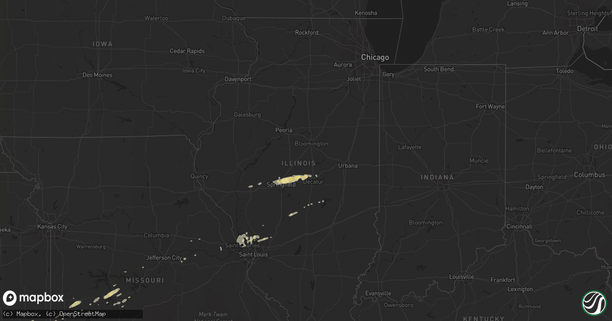
Hail Map in Illinois on April 15, 2013
Get this storm
April 15 map
$229
one time, instant access
Download today. No call, no setup
Keep the $229
Bought the map and want the full workflow? Apply the entire $229 to a subscription within 7 days. None of it is wasted.
Every map, not just this one
This buys you this map. Subscription and you get every map we run, in the markets you choose from a few cities to whole states to nationwide. Plus real-time alerts the moment a storm fires.
Contact data
Name, contact info, occupancy, even credit band for addresses in the footprint. You go from where it hit to who to call.
Become the source they trust
Unlimited branding weather history reports on demand. You already have the documented answer ready for the property owner, and you are the one who showed up with it.
Property data and RoofTrace estimates
Pull up any address you have got, its value and the exact code rules for that jurisdiction, straight from One Click Code. Then RoofTrace estimates the squares, pitch, and roof value, priced the way you price.
Storm reports in Illinois
Illinois
| Date | Description |
|---|---|
| 04/15/201312:05 PM CDT | Reports from pea size to up to quarter size hail in east alton and wood river. |
| 04/15/201312:15 AM CDT | Delayed report. Semi trailer knocked over on old hwy 36. Numerous branches knocked down. |
| 04/15/201312:10 AM CDT | Delayed report. Fruit tree snapped in half. Large fence knocked down. Shingles ripped from roof. |
| 04/15/201312:05 AM CDT | Delayed report. Roof blown off a building on cook street. From wics-tv |
Cities Impacted by Hail Map on April 15, 2013
- West Alton, MO
- Montgomery City, MO
- New Florence, MO
- Pittsburg, KS
- Cherryvale, KS
- Dennis, KS
- Parsons, KS
- Saint Paul, KS
- Girard, KS
- McCune, KS
- Urbana, MO
- Tunas, MO
- Stuart, FL
- Wanette, OK
- Tecumseh, OK
- Macomb, OK
- Maud, OK
- Saint Charles, MO
- Godfrey, IL
- Alton, IL
- Bethalto, IL
- Florissant, MO
- Louisburg, MO
- Half Way, MO
- Polk, MO
- Humansville, MO
- Collins, MO
- Weaubleau, MO
- Chico, TX
- Alvord, TX
- Sunset, TX
- Bowie, TX
- Worden, IL
- Hobe Sound, FL
- Milo, MO
- Sheldon, MO
- El Dorado Springs, MO
- Dawson, IL
- Warrensburg, IL
- Mount Pulaski, IL
- Williamsville, IL
- Latham, IL
- Buffalo, IL
- Sherman, IL
- Riverton, IL
- Illiopolis, IL
- Niantic, IL
- Springfield, IL
- Fort Pierce, FL
- Lamar, MO
- Wewoka, OK
- Jacksboro, TX
- Okeechobee, FL
- Opolis, KS
- Asbury, MO
- Oronogo, MO
- Mindenmines, MO
- Walker, MO
- Harwood, MO
- Preston, MO
- Cantrall, IL
- Forestburg, TX
- Cross Timbers, MO
- Wheatland, MO
- Hermitage, MO
- Hermann, MO
- Edwards, MO
- Jermyn, TX
- Loving, TX
- Palm Beach Gardens, FL
- Jupiter, FL
- Elkhart, IL
- Pleasant Plains, IL
- Mound Valley, KS
- Walnut, KS
- Edwardsville, IL
- Moro, IL
- East Alton, IL
- Wood River, IL
- Nokomis, IL
- Portage Des Sioux, MO
- Seminole, OK
- Buffalo, MO
- Weir, KS
- Cherokee, KS
- Frontenac, KS
- Liberal, MO
- Dow, IL
- Grafton, IL
- Elsah, IL
- Findlay, IL
- Foristell, MO
- Stockton, MO
- Earlsboro, OK
- Wetumka, OK
- Holdenville, OK
- Warsaw, MO
- Linn, MO
- Chamois, MO
- Morrison, MO
- Flemington, MO
- Raymond, IL
- Eldon, MO
- Stover, MO
- Pana, IL
- Lake Placid, FL
- Palm Beach, FL
- West Palm Beach, FL
- Assumption, IL
- Oreana, IL
- Alexander, IL
- Jacksonville, IL
- Macks Creek, MO
- Shawnee, OK
- Bridgeton, MO
- Golden Eagle, IL
- Jerico Springs, MO
- Maryland Heights, MO
- Shipman, IL
- Graham, TX
- Bryson, TX
- Shelbyville, IL
- Jensen Beach, FL
- Arcadia, KS
- Mulberry, KS
- High Hill, MO
- Bellevue, TX
- Chapin, IL
- Brussels, IL
- Hazelwood, MO
- Earth City, MO


