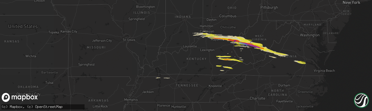
Hail Map in Kentucky on April 14, 2025
The weather event in Kentucky on April 14, 2025 includes Hail and Wind maps. 7 states and 365 cities were impacted and suffered possible damage. The total estimated number of properties impacted is 53,020.
Want more than just the map?
Turn this storm into a full workflow.
- Owner + property data so you know who to knock
- OnDemand branded weather history reports to win the "did we even have hail?" argument
- RoofTrace estimate so reps stop guessing numbers at the door
Bought this map? Upgrade within 7 days and we'll credit the $230. (10-15 min setup call)
Hail
Wind
53,020
Estimated number of impacted properties by a 1.00" hail or larger5,827
Estimated number of impacted properties by a 1.75" hail or larger1,124
Estimated number of impacted properties by a 2.50" hail or largerStorm reports in Kentucky
Kentucky
| Date | Description |
|---|---|
| 04/14/20256:49 PM CDT | Multiple social media videos of hail falling near stable branch road and ky-30. Lots of smaller hail scattered on the ground... But there are also multiple quarter-size |
| 04/14/20256:32 PM CDT | A public report of half dollar sized hail with picture was received. The event time is radar estimated. |
| 04/14/20256:30 PM CDT | Picture sent to use through social media. |
| 04/14/20256:14 PM CDT | Report of tree down near the intersection of fixer road and hwy 11 north of zoe. Report through social media. |
| 04/14/20255:12 PM CDT | Two trees across the road. Time estimated based on radar. |
| 04/14/20255:10 PM CDT | Trees down... With one clipping corner of the house. Times estimated based on radar. |
| 04/14/20254:57 PM CDT | Tree down on scaffold lick road. Time estimated from radar. |
| 04/14/20253:40 PM CDT | Trees down. Time estimated based on radar. |
| 04/14/20253:40 PM CDT | Trees down. Time estimated based on radar. |
| 04/14/20253:38 PM CDT | Trees down. Time estimated based on radar. |
| 04/14/20253:24 PM CDT | Time is estimated by radar. |
| 04/14/20253:05 PM CDT | Photo verified. |
| 04/14/20252:56 PM CDT | Photo verified. |
| 04/14/20252:52 PM CDT | Video posted on social media. |
| 04/14/20252:34 PM CDT | Tree down. Time estimated from radar. |
| 04/13/202511:45 PM CDT | Corrects hail report from eolia. Social media picture of hail scattered on the ground in eolia. Multiple stones of at least quarter-size visible. Time estimated via rad |
| 04/13/202511:42 PM CDT | Social media report of quarter sized hail along highway 413 in baxter... Just to the north of harlan. Time estimated via radar. |
| 04/13/202511:41 PM CDT | Social media report of a downed tree along route 413 in baxter... Just to the north of harlan. Time estimated via radar. |
| 04/13/202511:39 PM CDT | Social media report of nickel to quarter sized hail in loyall... Ky between 12:35 and 12:40am. |
| 04/13/20258:10 PM CDT | Social media report of downed trees along island creek road in pike county. Time estimated via radar. |
| 04/13/20257:59 PM CDT | A public report from the lackey community with a picture of hail around quarter sized. The event time is radar estimated. |
| 04/13/20257:58 PM CDT | A public report from the garrett community with a picture of hail at least quarter sized. The event time is radar estimated. |
| 04/13/20257:57 PM CDT | Social media picture of measured quarter sized hail along community church road in hueysville... Ky. Time estimated via radar. |
| 04/13/20257:55 PM CDT | Social media photograph of various sized hail stones covering the ground in hippo. There are numerous large stones that stick out amongst the rest... And these are at l |
| 04/13/20257:43 PM CDT | Corrects previous hail report from decoy. Social media pictures of large... Approximately ping pong ball sized hail in decoy... Ky. Time estimated via radar. |
| 04/13/20257:32 PM CDT | Several trees were reported to be down along ky 476 about 3 miles from ky 15 with power out. |
| 04/13/20257:32 PM CDT | Quarter sized hail was reported about 3 miles on ky 476 from ky 15. |
| 04/13/20257:30 PM CDT | An outbuilding... A fence... And trees were knocked down and damaged as large hail around a quarter in size was also reported off of smith branch road between ruby dr a |
| 04/13/20257:20 PM CDT | A tree was reported to have been blown down onto ky route 30 near the shoulderblade community. The event time is radar estimated. |
All States Impacted by Hail Map on April 14, 2025
Cities Impacted by Hail Map on April 14, 2025
- Foster, KY
- Falmouth, KY
- Brooksville, KY
- Augusta, KY
- Dover, KY
- Germantown, KY
- Ripley, OH
- Maysville, KY
- Aberdeen, OH
- Dillsboro, IN
- Rising Sun, IN
- Aurora, IN
- Madison, IN
- Versailles, IN
- Vevay, IN
- Manchester, OH
- West Union, OH
- Vanceburg, KY
- Verona, KY
- Walton, KY
- Cross Plains, IN
- Warsaw, KY
- Dry Ridge, KY
- Glencoe, KY
- De Mossville, KY
- Holton, IN
- Patriot, IN
- Florence, IN
- Crittenden, KY
- Morning View, KY
- Alexandria, KY
- Butler, KY
- California, KY
- Stout, OH
- Lynx, OH
- Blue Creek, OH
- Neville, OH
- Felicity, OH
- Moscow, OH
- Burlington, KY
- Union, KY
- Florence, KY
- Independence, KY
- Latonia, KY
- Bethel, OH
- Georgetown, OH
- South Shore, KY
- Friendship, OH
- West Portsmouth, OH
- Quincy, KY
- South Portsmouth, KY
- Hamersville, OH
- Cincinnati, OH
- Petersburg, KY
- New Richmond, OH
- Greenup, KY
- Franklin Furnace, OH
- Ironton, OH
- Pedro, OH
- Russellville, OH
- Sardinia, OH
- Garrison, KY
- Kitts Hill, OH
- Winchester, OH
- Dupont, IN
- North Vernon, IN
- Butlerville, IN
- Seaman, OH
- Peebles, OH
- Scottown, OH
- Willow Wood, OH
- Crown City, OH
- Chesapeake, OH
- Proctorville, OH
- South Point, OH
- Glenwood, WV
- Lesage, WV
- Bennington, IN
- Canaan, IN
- Otway, OH
- Ft Mitchell, KY
- Ona, WV
- Milton, WV
- Fraziers Bottom, WV
- Hurricane, WV
- Culloden, WV
- Winfield, WV
- Scott Depot, WV
- Hebron, KY
- Ashton, WV
- Portsmouth, OH
- McDermott, OH
- Lucasville, OH
- Minford, OH
- Saint Albans, WV
- Poca, WV
- Nitro, WV
- Charleston, WV
- Dunbar, WV
- South Webster, OH
- Wheelersburg, OH
- Erlanger, KY
- Elkview, WV
- Gallipolis Ferry, WV
- Apple Grove, WV
- Gallipolis, OH
- Patriot, OH
- Newport, KY
- Melbourne, KY
- Oak Hill, OH
- Waterloo, OH
- South Charleston, WV
- Clendenin, WV
- Tad, WV
- Blount, WV
- Bomont, WV
- Glen, WV
- Pond Gap, WV
- Henderson, WV
- Southside, WV
- Red House, WV
- Leon, WV
- Buffalo, WV
- Given, WV
- Liberty, WV
- Kenna, WV
- Indore, WV
- Lizemores, WV
- Bickmore, WV
- Mammoth, WV
- Swiss, WV
- Belva, WV
- Dixie, WV
- Montgomery, WV
- Clay, WV
- Summersville, WV
- Drennen, WV
- Victor, WV
- Advent, WV
- Worthington, KY
- Walton, WV
- Gandeeville, WV
- Amma, WV
- Left Hand, WV
- Looneyville, WV
- Mount Nebo, WV
- Nettie, WV
- Canvas, WV
- Fenwick, WV
- Russell, KY
- Leivasy, WV
- Quinwood, WV
- Richwood, WV
- Eleanor, WV
- Pool, WV
- Mount Lookout, WV
- Renick, WV
- Procious, WV
- Maysel, WV
- Hillsboro, WV
- Craigsville, WV
- Calvin, WV
- Tioga, WV
- Camden On Gauley, WV
- Marlinton, WV
- White Sulphur Springs, WV
- Hot Springs, VA
- Warm Springs, VA
- Beattyville, KY
- Hico, WV
- Buckeye, WV
- Irvine, KY
- Ravenna, KY
- Zoe, KY
- Campton, KY
- Rogers, KY
- Cowen, WV
- Nallen, WV
- Millboro, VA
- Covington, VA
- Huntington, WV
- Ashland, KY
- Catlettsburg, KY
- Clifton Forge, VA
- Barboursville, WV
- Salt Rock, WV
- West Hamlin, WV
- Goshen, VA
- Lexington, VA
- Vancleve, KY
- Salyersville, KY
- Jackson, KY
- Williamsburg, WV
- Tornado, WV
- Bays, KY
- Rockbridge Baths, VA
- Fairfield, VA
- Vesuvius, VA
- Buena Vista, VA
- Royalton, KY
- Prestonsburg, KY
- Staffordsville, KY
- Flatgap, KY
- East Point, KY
- Stambaugh, KY
- Oil Springs, KY
- Adams, KY
- Sitka, KY
- Louisa, KY
- Wittensville, KY
- Blaine, KY
- Hagerhill, KY
- Paintsville, KY
- Montebello, VA
- Tyro, VA
- Rousseau, KY
- Booneville, KY
- Roseland, VA
- Argillite, KY
- Flatwoods, KY
- Lovingston, VA
- Lost Creek, KY
- Clayhole, KY
- Shipman, VA
- Schuyler, VA
- Vest, KY
- Wayne, WV
- Lewisburg, WV
- Lavalette, WV
- Caldwell, WV
- Mousie, KY
- Hueysville, KY
- Wayland, KY
- Garrett, KY
- Gunlock, KY
- Langley, KY
- Eastern, KY
- Minnie, KY
- Drift, KY
- Lackey, KY
- McDowell, KY
- Printer, KY
- Banner, KY
- Grethel, KY
- Branchland, WV
- East Lynn, WV
- Leburn, KY
- Blue River, KY
- Hamlin, WV
- Esmont, VA
- Howardsville, VA
- Wingina, VA
- Prichard, WV
- Eagle Rock, VA
- Ashford, WV
- Alum Creek, WV
- Sod, WV
- Sumerco, WV
- Harold, KY
- Lowmansville, KY
- Ulysses, KY
- Puryear, TN
- Buchanan, TN
- Monroe, VA
- Amherst, VA
- Griffithsville, WV
- Yawkey, WV
- Teaberry, KY
- Arrington, VA
- Martin, KY
- Pikeville, KY
- Shelbiana, KY
- Raccoon, KY
- Phyllis, KY
- Kimper, KY
- Fedscreek, KY
- Phelps, KY
- Steele, KY
- Natural Bridge, VA
- Buchanan, VA
- Natural Bridge Station, VA
- Springville, TN
- Big Sandy, TN
- Spurlockville, WV
- Harts, WV
- Cabin Creek, WV
- Drybranch, WV
- Eskdale, WV
- Belle, WV
- East Bank, WV
- Glasgow, WV
- Dover, TN
- Stewart, TN
- Alkol, WV
- Hernshaw, WV
- Piney River, VA
- Scottsville, VA
- Mouthcard, KY
- Big Rock, VA
- Grundy, VA
- Hurley, VA
- Cedar Grove, WV
- Winifrede, WV
- Hansford, WV
- Julian, WV
- Iaeger, WV
- Panther, WV
- Clarksville, TN
- Cumberland City, TN
- Indian Mound, TN
- Palmyra, TN
- Cunningham, TN
- Amelia Court House, VA
- Jetersville, VA
- Chesterfield, VA
- Moseley, VA
- Church Road, VA
- Varney, KY
- Petersburg, VA
- Midlothian, VA
- Prince George, VA
- Colonial Heights, VA
- Chester, VA
- Hopewell, VA
- Manchester, KY
- Big Creek, KY
- Hyden, KY
- Mozelle, KY
- Wooton, KY
- Yeaddiss, KY
- Slemp, KY
- Gordon, KY
- Delphia, KY
- Cornettsville, KY
- Linefork, KY
- Hallie, KY
- Whitesburg, KY
- Cumberland, KY
- Partridge, KY
- Appalachia, VA
- Wise, VA
- Stoney Fork, KY
- Coldiron, KY
- Bledsoe, KY
- Wallins Creek, KY
- Norton, VA
- Baxter, KY
- Loyall, KY
- Harlan, KY
- Dayhoit, KY
- Eolia, KY
- Wendover, KY
- Midlothian, TX
- Venus, TX
- Waxahachie, TX
- Ennis, TX
- Mansfield, TX
- Red Oak, TX
- Palmer, TX
- Ferris, TX
- Stopover, KY
- Mohawk, WV
- Matewan, WV
- Chapmanville, WV
- Danville, WV


