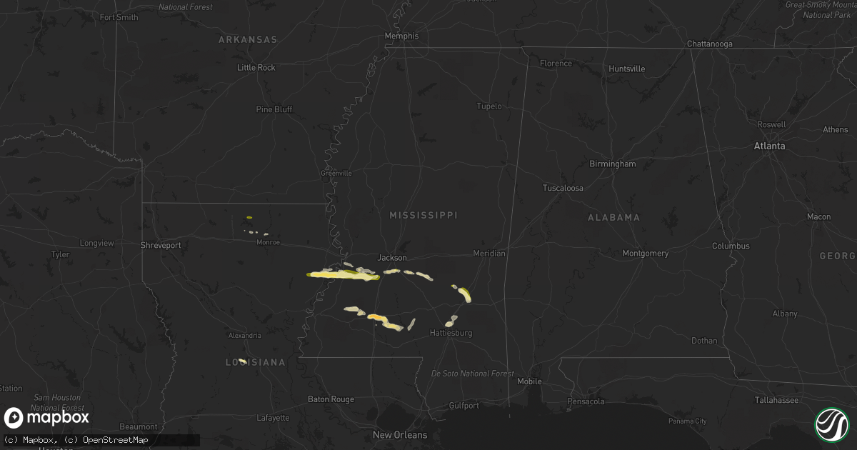
Hail Map in Mississippi on April 14, 2016
Get this storm
April 14 map
$229
one time, instant access
Download today. No call, no setup
Keep the $229
Bought the map and want the full workflow? Apply the entire $229 to a subscription within 7 days. None of it is wasted.
Every map, not just this one
This buys you this map. Subscription and you get every map we run, in the markets you choose from a few cities to whole states to nationwide. Plus real-time alerts the moment a storm fires.
Contact data
Name, contact info, occupancy, even credit band for addresses in the footprint. You go from where it hit to who to call.
Become the source they trust
Unlimited branding weather history reports on demand. You already have the documented answer ready for the property owner, and you are the one who showed up with it.
Property data and RoofTrace estimates
Pull up any address you have got, its value and the exact code rules for that jurisdiction, straight from One Click Code. Then RoofTrace estimates the squares, pitch, and roof value, priced the way you price.
Storm reports in Mississippi
Mississippi
| Date | Description |
|---|---|
| 04/14/20165:20 PM CDT | A local report indicates 1.00 inch wind near ESE SANDERSVILLE |
| 04/14/20165:10 PM CDT | Scattered trees and powerlines downed across the county |
| 04/14/20164:43 PM CDT | Relayed via social media. |
| 04/14/20164:20 PM CDT | A local report indicates 1.00 inch wind near 2 E TOPEKA |
| 04/14/20164:15 PM CDT | Several trees were blown down or uprooted and a few powerlines brought down by straight line winds |
| 04/14/20164:15 PM CDT | Several trees were blown down or uprooted and a few powerlines brought down by straight line winds along the south side of the community |
| 04/14/20163:25 PM CDT | Hail occurred just east of the i-55 and us hwy 84 intersection. Hail covering the ground and looks like snow. |
| 04/14/20163:25 PM CDT | Hail occurred just east of the i-55 and us hwy 84 intersection. Hail covering the ground and looks like snow. |
| 04/14/20163:18 PM CDT | Occurred at intersection of highways 84 and 51. |
| 04/14/20163:09 PM CDT | Hailed for 15 to 20 minutes. |
| 04/14/20162:55 PM CDT | A local report indicates 1.00 inch wind near 4 SE JOHNS |
| 04/14/20161:51 PM CDT | Dime to quarter size hail fell along white street just south of florence. |
| 04/14/20161:24 PM CDT | Via social media. |
All States Impacted by Hail Map on April 14, 2016
Cities Impacted by Hail Map on April 14, 2016
- Deltona, FL
- New Smyrna Beach, FL
- Davenport, FL
- Kissimmee, FL
- Union Church, MS
- Meadville, MS
- Magee, MS
- Raleigh, MS
- Lake Wales, FL
- Newellton, LA
- Terry, MS
- Columbia, MS
- Oak Vale, MS
- Frostproof, FL
- Lakeland, FL
- Polk City, FL
- Port Saint Lucie, FL
- Port Gibson, MS
- Utica, MS
- Hermanville, MS
- Florence, MS
- Moore Haven, FL
- Carson, MS
- Bartow, FL
- Babson Park, FL
- Bogue Chitto, MS
- Brookhaven, MS
- Laurel, MS
- Heidelberg, MS
- Glenmora, LA
- Petal, MS
- Hattiesburg, MS
- Moselle, MS
- Vicksburg, MS
- Crystal Springs, MS
- Indian Lake Estates, FL
- Lake Alfred, FL
- Haines City, FL
- Kenansville, FL
- Brandon, MS
- Braxton, MS
- Palm Bay, FL
- Fellsmere, FL
- Jayess, MS
- Monticello, MS
- Ruth, MS
- McCall Creek, MS
- Bay Springs, MS
- Okeechobee, FL
- Morton, MS
- Fayette, MS
- Winter Haven, FL
- Saint Cloud, FL
- Ismay, MT
- Volborg, MT
- Auburndale, FL
- Stringer, MS
- Downsville, LA
- Collins, MS
- Mendenhall, MS
- Fort Pierre, SD
- Newell, SD
- Vale, SD
- Nisland, SD
- Whitewood, SD
- Ville Platte, LA
- Sturgis, SD
- New Underwood, SD
- Ellisville, MS
- Vero Beach, FL
- Sebastian, FL
- Choudrant, LA
- Dupree, SD
- Monroe, LA
- Byram, MS
- Farmerville, LA
- Nalcrest, FL


