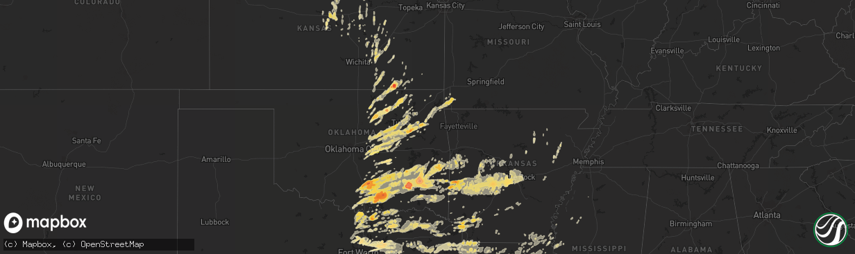
Hail Map in Texas on April 14, 2011
The weather event in Texas on April 14, 2011 includes Hail map. 8 states and 705 cities were impacted and suffered possible damage. The total estimated number of properties impacted is 0.
Want more than just the map?
Turn this storm into a full workflow.
- Owner + property data so you know who to knock
- OnDemand branded weather history reports to win the "did we even have hail?" argument
- RoofTrace estimate so reps stop guessing numbers at the door
Bought this map? Upgrade within 7 days and we'll credit the $230. (10-15 min setup call)
Hail
0
Estimated number of impacted properties by a 1.00" hail or larger0
Estimated number of impacted properties by a 1.75" hail or larger0
Estimated number of impacted properties by a 2.50" hail or largerStorm reports in Texas
Texas
| Date | Description |
|---|---|
| 04/14/20111:10 AM CDT | Tree downed across fm 989 and blankinship road. Tree downed across south bound hwy 59 and a tree down across gun club and perry demarce road. |
| 04/14/20111:05 AM CDT | Several trees were downed in the liberty-eylau community. |
| 04/14/20111:00 AM CDT | A small building was damaged along with small trees downed in redwater texas. |
| 04/14/201112:25 AM CDT | A roof was taken off a house off county road 4320. Also reports of trees in the yard twisted off close to the ground. |
| 04/14/201112:18 AM CDT | Estimated in terrell |
| 04/13/201111:30 PM CDT | Quarter size hail reported in rockwall. |
| 04/13/201111:18 PM CDT | In covington |
| 04/13/201111:10 PM CDT | Golfball size hail in garland |
| 04/13/201111:10 PM CDT | 74 mph wind gust in garland |
| 04/13/201111:07 PM CDT | 64 mph wind gust and nickel size hail in garland |
| 04/13/201111:05 PM CDT | Egg size hail in sachse |
| 04/13/201110:56 PM CDT | 80 mph wind gust in garland |
| 04/13/201110:55 PM CDT | 2 homes damaged in honey grove |
| 04/13/201110:54 PM CDT | Golfball size hail in leonard |
| 04/13/201110:49 PM CDT | Quarter size hail and wind gusts between 45 and 55 mph |
| 04/13/201110:48 PM CDT | Quarter size hail and 40 to 50 mph winds in plano |
| 04/13/201110:46 PM CDT | A nws storm survey concluded an ef-0 tornado initially touched down about 1 mile northwest of honey grove near the intersection of county road 2781 and highway 182. The |
| 04/13/201110:43 PM CDT | Quarter size hail in hebron and the colony |
| 04/13/201110:39 PM CDT | Quarter size hail in plano |
| 04/13/201110:27 PM CDT | Quarter size hail at alliance airport |
| 04/13/201110:22 PM CDT | Quarter hail fm 2499 4 miles n of fm 1171 |
| 04/13/201110:21 PM CDT | Dimes to quarter in lewisville |
| 04/13/201110:18 PM CDT | Quarter size hail 1 north of southlake |
| 04/13/201110:13 PM CDT | Golfball size hail in trophy club and roanoke |
| 04/13/201110:12 PM CDT | Dime to quarter size hail in trophy club |
| 04/13/201110:10 PM CDT | Quarter size hail in roanoke |
| 04/13/201110:07 PM CDT | Quarter size hail in justin |
| 04/13/20119:40 PM CDT | Golfball size hail in whitesboro |
| 04/13/20119:39 PM CDT | Ping pong ball size hail in whitesboro |
| 04/13/20119:37 PM CDT | Quarter size hail 2 south of valley view |
| 04/13/20119:27 PM CDT | Quarter size hail in denison |
| 04/13/20119:24 PM CDT | Quarter size hail in era |
| 04/13/20119:18 PM CDT | Quarter size hail in lindsay and northwest of gainesville |
| 04/13/20119:15 PM CDT | Quarter to half dollar size hail in preston |
| 04/13/20119:13 PM CDT | Half dollar size hail in pottsboro |
| 04/13/20119:07 PM CDT | Quarter size hail 4 southwest of gainesville |
| 04/13/20119:04 PM CDT | A local report indicates 1.00 inch wind near MYRA |
| 04/13/20118:59 PM CDT | Golfball size hail in moss lake |
| 04/13/20118:40 PM CDT | Quarter size hail in whitesboro |
| 04/13/20118:13 PM CDT | Quarter size hail briefly on interstate 35 in gainesville |
All States Impacted by Hail Map on April 14, 2011
Cities Impacted by Hail Map on April 14, 2011
- Ramona, OK
- Kingston, OK
- Maud, OK
- Wewoka, OK
- Poteau, OK
- Minden, LA
- Homer, LA
- Sulphur, OK
- Sedan, KS
- Peru, KS
- Pottsboro, TX
- Sherman, TX
- Whitesboro, TX
- Sadler, TX
- Norman, AR
- Holdenville, OK
- Mena, AR
- Southlake, TX
- Cambridge, KS
- Dexter, KS
- Broken Bow, OK
- Salina, OK
- Locust Grove, OK
- Eucha, OK
- Jay, OK
- Spavinaw, OK
- Ada, OK
- Dardanelle, AR
- Danville, AR
- Gainesville, TX
- Jefferson, TX
- Arcadia, LA
- Simsboro, LA
- Bossier City, LA
- Benton, LA
- Sibley, LA
- Gibsland, LA
- Haughton, LA
- Princeton, LA
- Ruston, LA
- Athens, LA
- Dubberly, LA
- Dubach, LA
- Plainview, AR
- Bartlesville, OK
- Ochelata, OK
- Wright City, OK
- Whitewright, TX
- Van Alstyne, TX
- Boles, AR
- Okmulgee, OK
- Beggs, OK
- Muenster, TX
- Thackerville, OK
- Greenleaf, KS
- Morrison, OK
- Haskell, OK
- Porter, OK
- Shreveport, LA
- Atoka, OK
- Coalgate, OK
- Centrahoma, OK
- Colbert, OK
- Plain Dealing, LA
- Anderson, MO
- Goodman, MO
- Wylie, TX
- Rockwall, TX
- Rowlett, TX
- Stroud, OK
- Depew, OK
- Hot Springs National Park, AR
- Hot Springs Village, AR
- Burns, KS
- Wilburton, OK
- Quinton, OK
- Boley, OK
- Okemah, OK
- Oak Ridge, LA
- Wister, OK
- Wagoner, OK
- Waldron, AR
- Batesville, MS
- Whitney, TX
- Covington, TX
- Itasca, TX
- Milford, TX
- Blum, TX
- Hillsboro, TX
- Grandview, TX
- Rio Vista, TX
- Oologah, OK
- Collinsville, OK
- Neosho, MO
- Antlers, OK
- Daisy, OK
- Delaware, OK
- Dewey, OK
- Barnsdall, OK
- Rattan, OK
- Kellyville, OK
- Sapulpa, OK
- Bristow, OK
- Mannsville, OK
- Madill, OK
- Tishomingo, OK
- Mill Creek, OK
- Kenefic, OK
- Wapanucka, OK
- Milburn, OK
- Coleman, OK
- Texarkana, AR
- Texarkana, TX
- Athol, KS
- Cassoday, KS
- Talihina, OK
- Smithville, OK
- Vandervoort, AR
- Watson, OK
- Oden, AR
- Cove, AR
- Hatfield, AR
- Avinger, TX
- Howe, TX
- El Dorado, KS
- Leon, KS
- Chouteau, OK
- Abilene, KS
- Hope, KS
- Enterprise, KS
- Chapman, KS
- Mcalester, OK
- Stuart, OK
- Wardville, OK
- Hodgen, OK
- Rodessa, LA
- Bivins, TX
- Doddridge, AR
- Ida, LA
- Council Grove, KS
- Tampa, KS
- Benton, AR
- Era, TX
- Valley View, TX
- Sanger, TX
- Hominy, OK
- Fairfax, OK
- Wynona, OK
- Karnack, TX
- Vivian, LA
- Mooringsport, LA
- Maple City, KS
- Newkirk, OK
- Marietta, OK
- Shidler, OK
- Burbank, OK
- Pawhuska, OK
- Bokoshe, OK
- Shady Point, OK
- Clayton, OK
- Stringtown, OK
- Mount Pleasant, TX
- Prague, OK
- Esbon, KS
- Jennings, OK
- Amity, AR
- Oak Grove, LA
- Eudora, AR
- Huntington, AR
- Greenwood, AR
- Mansfield, AR
- Beverly, KS
- Lincoln, KS
- Barnard, KS
- Terrell, TX
- Quinlan, TX
- Forney, TX
- Wills Point, TX
- Wolfe City, TX
- Ladonia, TX
- Bonham, TX
- Leonard, TX
- Trenton, TX
- Bailey, TX
- Winnsboro, TX
- Gilmer, TX
- Paron, AR
- Coweta, OK
- Dallas, TX
- Garland, TX
- Bixby, OK
- Earlsboro, OK
- Talala, OK
- Carney, OK
- Shawnee, OK
- Jenks, OK
- Owasso, OK
- Meeker, OK
- Castle, OK
- Kiefer, OK
- Sparks, OK
- Catoosa, OK
- Sperry, OK
- Cushing, OK
- Tulsa, OK
- Wellston, OK
- Mounds, OK
- Chandler, OK
- Hulbert, OK
- Peggs, OK
- Glenpool, OK
- Paden, OK
- Claremore, OK
- Mannford, OK
- Inola, OK
- Drumright, OK
- Broken Arrow, OK
- Sand Springs, OK
- Pawnee, OK
- Gaylord, KS
- Cookville, TX
- Nashoba, OK
- Tuskahoma, OK
- Paris, TX
- Hope, AR
- Fort Smith, AR
- Lavaca, AR
- Booneville, AR
- Charleston, AR
- Grand Cane, LA
- Deport, TX
- Bogata, TX
- Emory, TX
- Honobia, OK
- Locust Grove, AR
- Batesville, AR
- Denison, TX
- Yale, OK
- Valliant, OK
- Fort Worth, TX
- Carrollton, TX
- Coppell, TX
- Flower Mound, TX
- Argyle, TX
- Haslet, TX
- Justin, TX
- Sachse, TX
- Roanoke, TX
- Caddo Mills, TX
- Ponder, TX
- Plano, TX
- Nevada, TX
- The Colony, TX
- Mesquite, TX
- Lewisville, TX
- Lake Dallas, TX
- Addison, TX
- Grapevine, TX
- Royse City, TX
- Richardson, TX
- Irving, TX
- Newark, TX
- Lavon, TX
- Rhome, TX
- Jamestown, LA
- Jessieville, AR
- Yantis, TX
- Tenaha, TX
- Carthage, TX
- Logansport, LA
- Downs, KS
- Tipton, KS
- Glen Elder, KS
- Red Rock, OK
- Stratford, OK
- Byars, OK
- Mankato, KS
- Lebanon, KS
- Anna, TX
- Blue Ridge, TX
- Ore City, TX
- Linden, TX
- Pittsburg, TX
- Springhill, LA
- Hughes Springs, TX
- Lone Star, TX
- Montalba, TX
- Ardmore, OK
- Stonewall, OK
- Marietta, TX
- Naples, TX
- Douglassville, TX
- Perry, AR
- Morrilton, AR
- Roxton, TX
- Klondike, TX
- Commerce, TX
- Pecan Gap, TX
- Cooper, TX
- Lake Creek, TX
- Enloe, TX
- Pattonville, TX
- Ben Franklin, TX
- Seneca, MO
- Gordonville, TX
- Hackett, AR
- Hickory Ridge, AR
- Tioga, TX
- Gunter, TX
- Lanagan, MO
- South West City, MO
- Noel, MO
- Grove, OK
- Bienville, LA
- Roff, OK
- Parsons, KS
- Nowata, OK
- Heavener, OK
- Burr Oak, KS
- Ralston, OK
- Marland, OK
- Ponca City, OK
- Malvern, AR
- Donaldson, AR
- Sunnyvale, TX
- Beloit, KS
- Ellsworth, KS
- Marion, KS
- Peabody, KS
- Eureka, KS
- Floral, AR
- Glencoe, OK
- Smith Center, KS
- Quitman, TX
- Quitman, LA
- Osborne, KS
- Portis, KS
- Wetumka, OK
- Adona, AR
- Houston, AR
- Perryville, AR
- Wakefield, KS
- Allen, TX
- Greenville, TX
- Denton, TX
- Keller, TX
- Bryant, AR
- Alexander, AR
- Lorraine, KS
- Newark, AR
- Charlotte, AR
- Sulphur Rock, AR
- Celina, TX
- Maramec, OK
- Bismarck, AR
- Florence, KS
- Newton, KS
- Haddam, KS
- Belleville, KS
- Cuba, KS
- Frisco, TX
- Haynesville, LA
- Langley, AR
- Story, AR
- Lonsdale, AR
- Bonnerdale, AR
- Little Rock, AR
- Bauxite, AR
- Umpire, AR
- Mabelvale, AR
- Sims, AR
- Pearcy, AR
- Mount Ida, AR
- Roland, AR
- Scott, AR
- Maumelle, AR
- Mountain Pine, AR
- North Little Rock, AR
- Glenwood, AR
- Caddo Gap, AR
- Royal, AR
- Pencil Bluff, AR
- Wilson, OK
- Burneyville, OK
- Overbrook, OK
- Allen, OK
- Ivanhoe, TX
- Ravenna, TX
- Larue, TX
- Tennessee Colony, TX
- Palestine, TX
- Kerens, TX
- Malakoff, TX
- Athens, TX
- Belleville, AR
- Midland, AR
- Hartford, AR
- Fouke, AR
- Chidester, AR
- Havana, KS
- Elk City, KS
- Clifton, KS
- Morganville, KS
- Clay Center, KS
- Diana, TX
- Heflin, LA
- Red Oak, OK
- Pittsburg, OK
- Snow, OK
- Bethel, OK
- Howe, OK
- Whitesboro, OK
- Bells, TX
- Mount Holly, AR
- Stephens, AR
- Clifton, TX
- Rayville, LA
- Gilliam, LA
- Springer, OK
- West Monroe, LA
- Brookville, KS
- Glasco, KS
- Kanopolis, KS
- Salina, KS
- Kirwin, KS
- Kensington, KS
- Gypsum, KS
- Mcpherson, KS
- Nash, TX
- Annona, TX
- Ector, TX
- Randolph, TX
- Honey Grove, TX
- Savoy, TX
- Omaha, TX
- Windom, TX
- Celeste, TX
- Dodd City, TX
- Avery, TX
- Blossom, TX
- Brookston, TX
- Petty, TX
- De Kalb, TX
- Talco, TX
- Clarksville, TX
- Big Sandy, TX
- Concordia, KS
- Rose, OK
- Ringgold, LA
- Narka, KS
- Red Cloud, NE
- Davis, OK
- Tom Bean, TX
- Rosston, TX
- Decatur, TX
- Saint Jo, TX
- Pilot Point, TX
- Lindsay, TX
- Sumner, TX
- Bastrop, LA
- Washington, AR
- Fulton, AR
- Severy, KS
- Piedmont, KS
- Point, TX
- Lone Oak, TX
- Mahaska, KS
- Norcatur, KS
- Stella, MO
- Greenwood, MS
- Wickes, AR
- Newport, AR
- Tecumseh, OK
- Fisher, AR
- McCrory, AR
- Wynne, AR
- Farmersville, TX
- Newhope, AR
- Mayflower, AR
- Jacksonville, AR
- Sherwood, AR
- Kirby, AR
- Briggsville, AR
- Traskwood, AR
- Hooks, TX
- Olpe, KS
- Fitzhugh, OK
- Wynnewood, OK
- Maud, TX
- Wilson, KS
- Cedar, KS
- Lone Grove, OK
- Como, TX
- Pickton, TX
- Leesburg, TX
- Mineola, TX
- Herington, KS
- White City, KS
- Collinsville, TX
- Mayersville, MS
- Rolling Fork, MS
- Chautauqua, KS
- Frankston, TX
- Farmerville, LA
- Belcher, LA
- Oil City, LA
- Tupelo, OK
- Aubrey, TX
- Blanchard, LA
- Barksdale Afb, LA
- Doyline, LA
- Telephone, TX
- Pioneer, LA
- Kiowa, OK
- Blanco, OK
- Hartshorne, OK
- Savanna, OK
- Lindsborg, KS
- Falun, KS
- Fort Towson, OK
- Hugo, OK
- Eagletown, OK
- Soper, OK
- Ringold, OK
- Rufe, OK
- Spencerville, OK
- Superior, NE
- Detroit, TX
- Melissa, TX
- Fittstown, OK
- Grapevine, AR
- Rison, AR
- Prescott, AR
- De Queen, AR
- Burden, KS
- Lake Village, AR
- Cedar Point, KS
- Elmdale, KS
- Durant, OK
- Calvin, OK
- Strawberry, AR
- Garland City, AR
- Rosston, AR
- Stamps, AR
- Lewisville, AR
- Ashdown, AR
- Ogden, AR
- Emmet, AR
- Bokchito, OK
- Hendrix, OK
- Independence, KS
- Caney, KS
- Cleveland, OK
- Stillwater, OK
- Leon, OK
- Moyers, OK
- Muse, OK
- Haileyville, OK
- Pottsville, AR
- Caney, OK
- Caddo, OK
- Ringling, OK
- Cameron, OK
- Krebs, OK
- Lane, OK
- Rover, AR
- Mccurtain, OK
- Grannis, AR
- Albion, OK
- Ola, AR
- Atwood, OK
- Dougherty, OK
- Crossett, AR
- Sterlington, LA
- Monroe, LA
- Calhoun, LA
- Epps, LA
- Mer Rouge, LA
- Marion, LA
- Downsville, LA
- Collinston, LA
- Eros, LA
- Choudrant, LA
- Tescott, KS
- Gary, TX
- Mckinney, TX
- Casa, AR
- Foreman, AR
- Sulphur Springs, TX
- Brashear, TX
- Alba, TX
- Weiner, AR
- Konawa, OK
- Heber Springs, AR
- Rose Bud, AR
- Assaria, KS
- Junction City, KS
- Branch, AR
- Scandia, KS
- Keota, OK
- Cotton Plant, AR
- Hillsboro, KS
- Lenapah, OK
- Cedar Vale, KS
- Cherryvale, KS
- Webber, KS
- Guide Rock, NE
- Minden, NE
- Chelsea, OK
- Bennington, OK
- Daingerfield, TX
- Bradley, AR
- Elm Grove, LA
- Pryor, OK
- Sasakwa, OK
- Fredonia, KS
- Bushton, KS
- Geneseo, KS
- Carthage, AR
- Sparkman, AR
- Kingsland, AR
- Ivan, AR
- Fordyce, AR
- Benton, KS
- Towanda, KS
- Agra, KS
- Grand Prairie, TX
- Arlington, TX
- Talmage, KS
- Cawker City, KS
- Hamburg, AR
- Rosalia, KS
- Cottonwood Falls, KS
- Morris, OK
- Augusta, KS
- Phillipsburg, KS
- Niotaze, KS
- Shongaloo, LA
- Wilsey, KS
- Lenora, KS
- Deshler, NE
- Byron, NE
- De Valls Bluff, AR
- Roe, AR
- Valley Mills, TX
- Cleburne, TX
- Vinita, OK
- Mineral Springs, AR
- Nashville, AR
- Italy, TX
- Parkdale, AR
- Atlanta, KS
- Wilmot, AR
- Jacksonville, TX
- Dustin, OK
- Grenola, KS
- Arkansas City, KS
- Calera, OK
- Morrowville, KS
- Greenville, MS
- Boswell, OK
- Doddsville, MS
- Anguilla, MS
- Inavale, NE
- Marquette, KS
- Bullard, TX
- Atkins, AR
- Hollandale, MS
- Lake Providence, LA
- Durham, KS
- Emporia, KS
- El Dorado, AR
- Edgewood, TX
- Springfield, AR
- Damascus, AR
- Greenbrier, AR
- Clyde, KS
- Taylor, AR
- Linn, KS
- Bluejacket, OK
- Bernice, LA
- Spiro, OK
- Strong City, KS
- Gillham, AR
- Sylvan Grove, KS
- Tyro, KS
- Wann, OK
- New Boston, TX
- Itta Bena, MS
- Schlater, MS
- Sarepta, LA
- Agenda, KS
- Fall River, KS
- Hosston, LA
- Grambling, LA
- Cotton Valley, LA
- Bonita, LA
- Portland, AR
- Jones, LA
- Buckner, AR
- Krum, TX
- Boyd, TX
- Azle, TX
- Cumby, TX
- Seminole, OK


