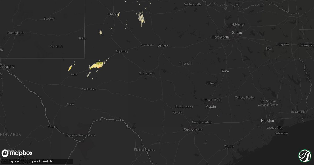
Hail Map in Texas on April 12, 2015
Get this storm
April 12 map
$229
one time, instant access
Download today. No call, no setup
Keep the $229
Bought the map and want the full workflow? Apply the entire $229 to a subscription within 7 days. None of it is wasted.
Every map, not just this one
This buys you this map. Subscription and you get every map we run, in the markets you choose from a few cities to whole states to nationwide. Plus real-time alerts the moment a storm fires.
Contact data
Name, contact info, occupancy, even credit band for addresses in the footprint. You go from where it hit to who to call.
Become the source they trust
Unlimited branding weather history reports on demand. You already have the documented answer ready for the property owner, and you are the one who showed up with it.
Property data and RoofTrace estimates
Pull up any address you have got, its value and the exact code rules for that jurisdiction, straight from One Click Code. Then RoofTrace estimates the squares, pitch, and roof value, priced the way you price.
Storm reports in Texas
Texas
| Date | Description |
|---|---|
| 04/12/20155:55 PM CDT | A local report indicates 1.75 inch wind near 4 SW MEMPHIS |
| 04/12/20155:45 PM CDT | A local report indicates 2.00 inch wind near 4 S MEMPHIS |
| 04/12/20155:37 PM CDT | The ector county s.o. Reported quarter size hail in south odessa. |
| 04/12/20155:25 PM CDT | A local report indicates 68 MPH wind near DRYDEN |
| 04/12/20155:25 PM CDT | A local report indicates 1.00 inch wind near 5 E MOBEETIE |
| 04/12/20155:05 PM CDT | A local report indicates 1.25 inch wind near 8 W ODESSA |
| 04/12/20154:38 PM CDT | The panther junction raws station reported a 59 mph gust. |
| 04/12/20153:50 PM CDT | The big bend portable raws station reported a 65 mph gust. |
| 04/12/20153:35 PM CDT | A local report indicates 1.75 inch wind near 2 W MENTONE |
| 04/11/201511:05 PM CDT | Power out across much of the city for about 10 minutes. Widespread power lines down. Time of event estimated by radar. |
| 04/11/201511:05 PM CDT | Trees down at frontage and bicentennial in mcallen. |
| 04/11/201510:45 PM CDT | Trees and powerlines down in premont on 6th street. |
| 04/11/20159:47 PM CDT | Trained weather spotter reported downed power pole in the city of zapata |
| 04/11/20159:25 PM CDT | Trees down in 1st and highway 83. |
| 04/11/20159:20 PM CDT | Down trees and powerlines in weslaco and rio lane. |
| 04/11/20159:17 PM CDT | Several trees reported down in zapata. Time estimated from radar. |
| 04/11/20159:15 PM CDT | 60 mph winds and 0.25 - 0.50 inch hail reported in addition to heavy rain and frequent lightning. Power outages are occurring. |
| 04/11/20158:32 PM CDT | An out building was damaged and steel bars were lying across the highway in a pattern from ne to sw. |
| 04/11/20158:28 PM CDT | A local report indicates 1.75 inch wind near 2 E WELLINGTON |
| 04/11/20157:54 PM CDT | A local report indicates 1.25 inch wind near 3 NNE WELLINGTON |
| 04/11/20157:00 PM CDT | Large tree uprooted in south midland. Picture from facebook. |
All States Impacted by Hail Map on April 12, 2015
Cities Impacted by Hail Map on April 12, 2015
- Aspermont, TX
- Red Cloud, NE
- Inavale, NE
- Imperial, TX
- Alcester, SD
- Kiowa, KS
- Alva, OK
- Burlington, OK
- Waldron, KS
- Hazelton, KS
- Ithaca, NE
- Yutan, NE
- Arcadia, NE
- Turkey, TX
- Hebbronville, TX
- Paynesville, MN
- Wellington, TX
- Shamrock, TX
- Crane, TX
- Childress, TX
- Columbus, NE
- Mahaska, KS
- Narka, KS
- Mooreland, OK
- Chester, OK
- Mutual, OK
- Mentone, TX
- Pecos, TX
- Post, TX
- Loop, TX
- Ireton, IA
- Odessa, TX
- Mobeetie, TX
- Wheeler, TX
- Blue Hill, NE
- Guide Rock, NE
- Albion, NE
- Valparaiso, NE
- Bruno, NE
- Colon, NE
- York, NE
- Schuyler, NE
- Wahoo, NE
- Fullerton, NE
- Benedict, NE
- Omaha, NE
- Silver Creek, NE
- Rising City, NE
- Ulysses, NE
- Clarkson, NE
- David City, NE
- Leigh, NE
- Weston, NE
- Elkhorn, NE
- Gretna, NE
- Prague, NE
- Shelby, NE
- Brainard, NE
- Clarks, NE
- Ashland, NE
- Mead, NE
- Waterloo, NE
- Surprise, NE
- Waco, NE
- Duncan, NE
- Osceola, NE
- Stromsburg, NE
- Bellwood, NE
- Central City, NE
- Malmo, NE
- Memphis, NE
- Gresham, NE
- Midland, TX
- Lakeview, TX
- Red Rock, TX
- Spearville, KS
- Offerle, KS
- Memphis, TX
- Thayer, IA
- Briscoe, TX
- Sharon, OK
- Laurel, NE
- Wayne, NE
- Carroll, NE
- South Haven, MN
- Kimball, MN
- Medicine Lodge, KS
- Zapata, TX
- Smith Center, KS
- Palmer, NE
- Hardtner, KS
- Hardy, NE
- Webber, KS
- Goldsmith, TX
- Woodward, OK
- San Ygnacio, TX
- Edinburg, TX
- Edcouch, TX
- Formoso, KS
- Mankato, KS
- Hawarden, IA
- Arnett, OK
- Carter, OK
- Courtland, KS
- Jewell, KS
- Cheyenne, OK
- Sweetwater, OK
- Jayton, TX
- Royalton, MN
- Canadian, TX
- Reydon, OK
- Scandia, KS
- Belleville, KS
- Howells, NE
- Saint Edward, NE
- Genoa, NE
- Shattuck, OK
- Odonnell, TX
- Attica, KS
- Kensington, KS
- Lebanon, KS
- Jamestown, KS
- Burr Oak, KS
- Esbon, KS
- Athol, KS
- Agenda, KS
- Norway, KS
- Concordia, KS
- Oakland, NE
- Hedley, TX
- Scribner, NE
- Snyder, NE
- Dodge, NE
- West Point, NE
- Isabel, KS
- Fremont, NE
- South Bend, NE
- Springfield, NE
- Louisville, NE
- Ceresco, NE
- Dwight, NE
- Pierz, MN
- Brainerd, MN
- Summerfield, KS
- Axtell, KS
- Beattie, KS
- Okeechobee, FL
- Cold Spring, MN
- Saint Cloud, MN
- Beloit, KS
- Marysville, KS
- Odell, NE
- Hanover, KS
- Bremen, KS
- Wymore, NE
- Oketo, KS
- Bryceville, FL
- Sabetha, KS
- Matador, TX
- Girard, TX
- Fairbury, NE
- Slaton, TX
- Hudson, SD
- Endicott, NE
- Reynolds, NE
- Hebron, NE
- Elk Point, SD
- Grandfalls, TX
- Lismore, MN
- Adrian, MN
- Watkins, MN
- Quail, TX
- Mission, TX
- Mcallen, TX
- Freedom, OK
- Platte Center, NE
- Monroe, NE
- Ord, NE
- Floydada, TX
- Linwood, NE
- Abie, NE
- Lake City, KS
- Jacksonville, FL
- Pattonsburg, MO
- Penitas, TX
- La Joya, TX
- Kearney, NE
- Kinsley, KS
- Higgins, TX
- Sun City, KS
- Dickens, TX
- Dodson, TX
- Falls City, TX
- Hobson, TX
- Spur, TX
- Buffalo, OK
- Rio Grande City, TX
- Brownfield, TX
- Guerra, TX
- Durham, OK
- Crawford, OK
- Christoval, TX
- Coats, KS
- Lubbock, TX
- Lorenzo, TX
- Monahans, TX
- Hillman, MN
- Paducah, TX
- Hammon, OK
- Auburn, NE
- Humboldt, NE
- Byron, NE
- Quanah, TX
- Richmond, MN
- Waynoka, OK
- Laredo, TX
- Bradshaw, NE
- Roaring Springs, TX
- Pender, NE
- Elk City, OK
- Saint Paul, NE
- La Pryor, TX
- Sayre, OK
- Humphrey, NE
- Seneca, KS
- Diller, NE
- Mound City, MO
- Baileyville, KS
- Lockney, TX
- Belgrade, NE
- Sawyer, KS
- Plainview, TX
- Rogers, NE
- Spicer, MN
- New London, MN
- Clay Center, NE
- Papillion, NE
- La Vista, NE


