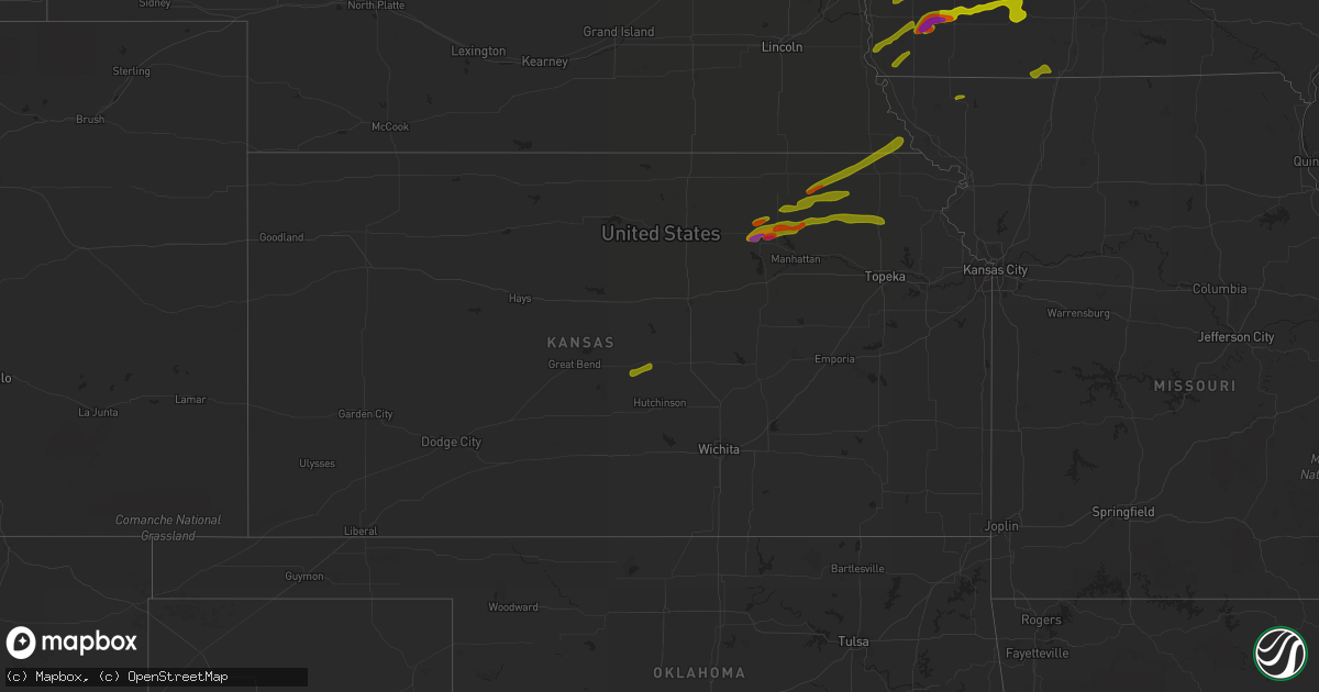
Hail Map in Kansas on April 12, 2014
Get this storm
April 12 map
$229
one time, instant access
Download today. No call, no setup
Keep the $229
Bought the map and want the full workflow? Apply the entire $229 to a subscription within 7 days. None of it is wasted.
Every map, not just this one
This buys you this map. Subscription and you get every map we run, in the markets you choose from a few cities to whole states to nationwide. Plus real-time alerts the moment a storm fires.
Contact data
Name, contact info, occupancy, even credit band for addresses in the footprint. You go from where it hit to who to call.
Become the source they trust
Unlimited branding weather history reports on demand. You already have the documented answer ready for the property owner, and you are the one who showed up with it.
Property data and RoofTrace estimates
Pull up any address you have got, its value and the exact code rules for that jurisdiction, straight from One Click Code. Then RoofTrace estimates the squares, pitch, and roof value, priced the way you price.
Storm reports in Kansas
Kansas
| Date | Description |
|---|---|
| 04/11/201410:20 PM CDT | A local report indicates 1.00 inch wind near HOLTON |
| 04/11/20149:15 PM CDT | A local report indicates 1.00 inch wind near BLAINE |
| 04/11/20149:08 PM CDT | A local report indicates 1.00 inch wind near 4 S BLAINE |
| 04/11/20148:54 PM CDT | A local report indicates 1.00 inch wind near 6 ENE OLSBURG |
| 04/11/20148:28 PM CDT | A local report indicates 1.25 inch wind near 3 E LEONARDVILLE |
| 04/11/20148:25 PM CDT | A local report indicates 1.25 inch wind near 2 W OLSBURG |
| 04/11/20148:22 PM CDT | A local report indicates 2.00 inch wind near 1 SE LEONARDVILLE |
| 04/11/20148:16 PM CDT | A local report indicates 1.00 inch wind near 5 NW SABETHA |
| 04/11/20148:15 PM CDT | A local report indicates 1.00 inch wind near 3 NE SENECA |
| 04/11/20148:13 PM CDT | A local report indicates 1.25 inch wind near 5 ESE LYONS |
| 04/11/20148:09 PM CDT | A local report indicates 1.75 inch wind near RANDOLPH |
| 04/11/20148:06 PM CDT | A local report indicates 1.00 inch wind near 6 N RANDOLPH |
| 04/11/20147:50 PM CDT | A local report indicates 1.75 inch wind near 5 N VERMILLION |
| 04/11/20147:47 PM CDT | A local report indicates 1.75 inch wind near 5 N VERMILLION |
| 04/11/20147:46 PM CDT | A local report indicates 1.25 inch wind near FRANKFORT |
| 04/11/20147:45 PM CDT | A local report indicates 1.50 inch wind near FRANKFORT |
| 04/11/20147:37 PM CDT | A local report indicates 1.00 inch wind near 7 E CLAY CENTER |
| 04/11/20147:30 PM CDT | A local report indicates 1.50 inch wind near 7 E CLAY CENTER |
| 04/11/20147:23 PM CDT | A local report indicates 2.00 inch wind near 6 ESE CLAY CENTER |
| 04/11/20147:05 PM CDT | A local report indicates 1.50 inch wind near 3 SE CLAY CENTER |
| 04/11/20147:00 PM CDT | A local report indicates 1.75 inch wind near 2 NE GREEN |
| 04/11/20147:00 PM CDT | A local report indicates 1.50 inch wind near 1 S CLAY CENTER |
All States Impacted by Hail Map on April 12, 2014
Cities Impacted by Hail Map on April 12, 2014
- Sauk City, WI
- Lodi, WI
- Arlington, WI
- Mazomanie, WI
- Prairie Du Sac, WI
- Poynette, WI
- La Crescent, MN
- Dakota, MN
- Peterson, MN
- Lanesboro, MN
- Houston, MN
- Rushford, MN
- Coon Valley, WI
- Bangor, WI
- Onalaska, WI
- La Crosse, WI
- West Salem, WI
- Wonewoc, WI
- Genoa, WI
- Westby, WI
- Cashton, WI
- Viroqua, WI
- Lyndon Station, WI
- Viola, WI
- La Valle, WI
- Hillsboro, WI
- Elroy, WI
- Wisconsin Dells, WI
- Kendall, WI
- La Farge, WI
- Ontario, WI
- Baraboo, WI
- Cazenovia, WI
- Reedsburg, WI
- Elkader, IA
- Volga, IA
- Elgin, IA
- Wadena, IA
- Westgate, IA
- Readlyn, IA
- Fairbank, IA
- Denver, IA
- Fayette, IA
- Maynard, IA
- West Union, IA
- Randalia, IA
- Waverly, IA
- Postville, IA
- Tripoli, IA
- Janesville, IA
- Saint Olaf, IA
- Sumner, IA
- Waucoma, IA
- Lawler, IA
- Fort Atkinson, IA
- Caledonia, MN
- Stoddard, WI
- Chaseburg, WI
- Brownsville, MN
- Nashua, IA
- Ionia, IA
- Plainfield, IA
- Allison, IA
- Clarksville, IA
- Lansing, IA
- Castalia, IA
- Clermont, IA
- Ossian, IA
- Decorah, IA
- Waukon, IA
- Cedar Falls, IA
- Dike, IA
- Aplington, IA
- Shell Rock, IA
- New Hartford, IA
- Parkersburg, IA
- Garwin, IA
- Gladbrook, IA
- Marshalltown, IA
- State Center, IA
- Lincoln, IA
- Grundy Center, IA
- Morrison, IA
- Reinbeck, IA
- Casey, IA
- Guthrie Center, IA
- Lehigh, IA
- Duncombe, IA
- Otho, IA
- Ogden, IA
- Boone, IA
- Kiron, IA
- Wall Lake, IA
- Odebolt, IA
- Vail, IA
- Deloit, IA
- Denison, IA
- Nevada, IA
- Colo, IA
- Red Oak, IA
- Prescott, IA
- Elliott, IA
- Orient, IA
- Afton, IA
- Creston, IA
- Villisca, IA
- Corning, IA
- Stanton, IA
- Bridgewater, IA
- Nodaway, IA
- Carbon, IA
- Stanhope, IA
- Jewell, IA
- Stratford, IA
- Story City, IA
- Randall, IA
- Radcliffe, IA
- Garden City, IA
- McCallsburg, IA
- Hubbard, IA
- Roland, IA
- Coulter, IA
- Hampton, IA
- Latimer, IA
- Wellsburg, IA
- Holland, IA
- Union, IA
- Steamboat Rock, IA
- Eldora, IA
- Ames, IA
- New Providence, IA
- Rockwell City, IA
- Jolley, IA
- Lytton, IA
- Mount Ayr, IA
- Kellerton, IA
- Malvern, IA
- Emerson, IA
- Tabor, IA
- Hastings, IA
- Percival, IA
- Imogene, IA
- Thurman, IA
- Randolph, IA
- Sidney, IA
- Treynor, IA
- Shenandoah, IA
- Farragut, IA
- Riverton, IA
- Hamburg, IA
- Carson, IA
- Macedonia, IA
- Silver City, IA
- Griswold, IA
- Essex, IA
- Randolph, KS
- Green, KS
- Maryville, MO
- Pickering, MO
- Burlington Junction, MO
- Pierson, MI
- Six Lakes, MI
- Lakeview, MI
- Morley, MI
- Howard City, MI
- Coral, MI
- Newaygo, MI
- Gowen, MI
- Casnovia, MI
- Greenville, MI
- Sparta, MI
- Sand Lake, MI
- Belding, MI
- Orleans, MI
- Kent City, MI
- Rockford, MI
- Cedar Springs, MI
- Fenwick, MI
- Twin Lake, MI
- Muskegon, MI
- Holton, MI
- Grant, MI
- Fremont, MI
- Montague, MI
- Whitehall, MI
- Westmoreland, KS
- Clay Center, KS
- Leonardville, KS
- Onaga, KS
- Holton, KS
- Olsburg, KS
- Riley, KS
- Havensville, KS
- Circleville, KS
- Manhattan, KS
- Soldier, KS
- Corning, KS
- Frankfort, KS
- Centralia, KS
- Blue Rapids, KS
- Vermillion, KS
- Baileyville, KS
- Hiawatha, KS
- Sabetha, KS
- Oneida, KS
- Falls City, NE
- Morrill, KS
- Salem, NE
- Bern, KS
- Seneca, KS
- West Bend, WI
- Sheboygan, WI
- Lomira, WI
- Campbellsport, WI
- Fond Du Lac, WI
- Brownsville, WI
- Mukwonago, WI
- Milwaukee, WI
- Union, IL
- Garden Prairie, IL
- Lake Zurich, IL
- Algonquin, IL
- Dundee, IL
- Wheeling, IL
- Harvard, IL
- Gilberts, IL
- Palatine, IL
- Winnebago, IL
- Poplar Grove, IL
- Mundelein, IL
- Lincolnshire, IL
- Hoffman Estates, IL
- Kingston, IL
- Carpentersville, IL
- Crystal Lake, IL
- Cary, IL
- German Valley, IL
- Mchenry, IL
- Pecatonica, IL
- Barrington, IL
- Arlington Heights, IL
- Wonder Lake, IL
- Kirkland, IL
- Marengo, IL
- Huntley, IL
- Cherry Valley, IL
- Fox River Grove, IL
- Hampshire, IL
- Lake In The Hills, IL
- Genoa, IL
- Woodstock, IL
- Vernon Hills, IL
- Wauconda, IL
- Capron, IL
- Rockford, IL
- Belvidere, IL
- Ringwood, IL
- Buffalo Grove, IL
- Ridott, IL
- Mayville, WI
- Beaver Dam, WI
- Juneau, WI
- Burnett, WI
- Horicon, WI
- Hartford, WI
- Pardeeville, WI
- Cambria, WI
- Fox Lake, WI
- Portage, WI
- Randolph, WI
- Highland Park, IL
- Rock City, IL
- Grayslake, IL
- Cedarville, IL
- Ingleside, IL
- Island Lake, IL
- Stillman Valley, IL
- Northbrook, IL
- Libertyville, IL
- Freeport, IL
- Lena, IL
- McConnell, IL
- Prospect Heights, IL
- Winnetka, IL
- Davis Junction, IL
- Glencoe, IL
- Deerfield, IL
- Fox Lake, IL
- Lake Forest, IL
- Loves Park, IL
- Round Lake, IL
- Highwood, IL
- Davis, IL
- Dakota, IL
- Hebron, IL
- Antioch, IL
- Lake Villa, IL
- Goodrich, MI
- Oxford, MI
- Swartz Creek, MI
- Grand Blanc, MI
- Oakland, MI
- Fenton, MI
- Clarkston, MI
- Lake Orion, MI
- Rochester, MI
- Linden, MI
- Ortonville, MI
- Washington, MI
- Holly, MI
- Little River, KS
- Sterling, KS
- Lyons, KS
- Waterville, IA
- Oconomowoc, WI
- Sussex, WI
- Hartland, WI
- New Berlin, WI
- Luana, IA
- Hawkeye, IA
- Austinville, IA
- Oelwein, IA
- Arlington, IA
- Stanley, IA
- Ackley, IA
- Waterloo, IA
- Elkhorn, WI
- Lake Geneva, WI
- Jesup, IA
- Raymond, IA
- Harcourt, IA
- Paton, IA
- Dayton, IA
- Sharon, WI
- Gowrie, IA
- Newton, IA
- Grinnell, IA
- Kellogg, IA
- Laurel, IA
- Tama, IA
- Montour, IA
- Gilman, IA
- Malcom, IA
- Ely, IA
- Cedar Rapids, IA
- Chariton, IA
- Rocheport, MO
- New Franklin, MO
- Fayette, MO
- Clarinda, IA
- Odessa, MO
- Sweet Springs, MO
- Alma, MO
- Concordia, MO
- Blackburn, MO
- Higginsville, MO
- Mayview, MO
- Wellington, MO
- Marshall, MO
- Corder, MO
- Malta Bend, MO
- Ravenna, MI
- Watertown, WI
- Moorland, IA
- Lohrville, IA
- Farnhamville, IA
- Somers, IA
- Cudahy, WI
- Oak Creek, WI
- South Milwaukee, WI
- Beloit, WI
- South Beloit, IL
- Craig, MO
- Fairfax, MO
- Verdon, NE
- Rubicon, WI
- Neosho, WI
- Germantown, WI
- Richfield, WI
- Jackson, WI
- Cedarburg, WI
- Dows, IA
- Scales Mound, IL
- Apple River, IL
- Columbus, WI
- Thayer, IA
- Promise City, IA
- Corydon, IA
- Allerton, IA
- Lineville, IA
- Clio, IA
- Davisburg, MI
- Wiota, IA
- Richmond, IL
- Spring Grove, IL
- Henderson, IA
- Franklin, MO
- Rockford, IA
- Sheboygan Falls, WI
- Kohler, WI
- De Soto, WI
- Hokah, MN
- Mauston, WI
- Ferryville, WI
- Soldiers Grove, WI
- Readstown, WI
- Rio, WI
- Deforest, WI
- Kenosha, WI
- Union Grove, WI
- Sturtevant, WI
- Fredericksburg, IA
- Spring Green, WI
- Gotham, WI
- Muscoda, WI
- Avoca, WI
- Lone Rock, WI
- Ionia, MI
- Webster City, IA
- Whitten, IA
- Gilbert, IA
- Zearing, IA
- Maxwell, IA
- Iowa Falls, IA
- Conrad, IA
- Ellsworth, IA
- Beaman, IA
- Kamrar, IA
- Liscomb, IA
- Albion, IA
- Clemons, IA
- Saint Anthony, IA
- Wyocena, WI
- Lebanon, WI
- Theresa, WI
- Colgate, WI
- Lowell, WI
- Reeseville, WI
- Menomonee Falls, WI
- Johnson Creek, WI
- Fall River, WI
- Sullivan, WI
- Saukville, WI
- Allenton, WI
- Hustisford, WI
- Merrimac, WI
- Belgium, WI
- Fredonia, WI
- Ixonia, WI
- Iron Ridge, WI
- Slinger, WI
- Kewaskum, WI
- Hubertus, WI
- Anita, IA
- Bellevue, IA
- Auxvasse, MO
- Kingdom City, MO
- Galena, IL
- Leon, IA
- Sheffield, IA
- Lamoni, IA
- Grant City, MO
- Hatfield, MO
- Port Washington, WI
- Salem, WI
- Burlington, WI
- Silver Lake, WI
- Marshall, WI
- Sun Prairie, WI
- Lenox, IA
- Waldo, WI
- Mount Horeb, WI
- Cross Plains, WI
- Chapin, IA
- Williams, IA
- Rockwell, IA
- Dougherty, IA
- Alden, IA
- Blairsburg, IA
- Winterset, IA
- Peru, IA
- Council Bluffs, IA
- Cumberland, IA
- Fontanelle, IA
- Cromwell, IA
- Gravity, IA
- Macksburg, IA
- New Virginia, IA
- Murray, IA
- Menlo, IA
- Greenfield, IA
- Truro, IA
- Osceola, IA
- Shannon City, IA
- Lorimor, IA
- Oakland, IA
- Manilla, IA
- Palmyra, WI
- East Troy, WI
- Eagle, WI
- Whitewater, WI
- Earling, IA
- Blakesburg, IA
- New Florence, MO
- Montgomery City, MO
- Dorchester, IA
- Higbee, MO
- Huntsville, MO
- Twin Lakes, WI
- Blythedale, MO
- Portsmouth, IA
- Shelby, IA
- Du Bois, NE
- Keytesville, MO
- Nashotah, WI
- Monona, IA
- Farmersburg, IA
- Gaines, MI
- Durand, MI
- Utica, MI
- Skidmore, MO
- Armstrong, MO
- Humboldt, NE
- Dawson, NE
- Manitowoc, WI
- Valders, WI
- Cottage Grove, WI
- Moravia, IA
- Westphalia, IA
- Harlan, IA
- Davis City, IA
- Glasgow, MO
- Pickett, WI
- Oshkosh, WI
- Pilot Mound, IA
- Milton, WI
- Charles City, IA
- Grand Junction, IA
- Rippey, IA
- Irwin, IA
- Panama, IA
- Defiance, IA
- Dexter, IA
- Stuart, IA
- Salisbury, MO
- Panora, IA
- Cowgill, MO
- De Kalb, MO
- Rothbury, MI
- New Era, MI
- Lake View, IA
- Genoa City, WI
- Brunswick, MO
- Dalton, MO
- Plain, WI
- Arena, WI
- Dane, WI
- Waupun, WI
- Woodburn, IA
- Lucas, IA
- Darien, WI
- Clinton, WI
- Chelsea, IA
- Coon Rapids, IA
- Waunakee, WI
- New Albin, IA
- Eitzen, MN
- Adair, IA
- Prairie Du Chien, WI
- Brookfield, WI
- Melbourne, IA
- Rochester, MN
- Harpers Ferry, IA
- Roscoe, IL
- Caledonia, IL
- Bagley, WI
- Mequon, WI
- Haverhill, IA
- Baxter, IA
- Rushville, MO
- Weston, MO
- Seymour, IA
- Russell, IA
- Fort Dodge, IA
- Hancock, IA
- Saint Joseph, MO
- Pawnee City, NE
- De Witt, MO
- Mendon, MO
- Columbia, MO
- Racine, WI
- Albia, IA
- Rulo, NE
- Blackwater, MO
- Prairie Home, MO
- Boonville, MO
- Wooldridge, MO
- Machesney Park, IL
- Wadsworth, IL
- Gurnee, IL
- Monroe Center, IL
- Cedar Grove, WI
- Loganville, WI
- Bailey, MI
- Deerfield, WI
- Waterloo, WI
- Calmar, IA
- Ottumwa, IA
- Gentry, MO
- Clutier, IA
- Traer, IA
- Dysart, IA
- Wauzeka, WI
- Wilmot, WI
- Massena, IA
- Newton, WI
- Kansasville, WI
- Toledo, IA
- Trenton, MO
- Darlington, WI
- White Cloud, MI
- Plano, IA
- Hazleton, IA
- Comstock Park, MI
- Pearl City, IL
- Byron, IL
- Perry, IA
- Ripon, WI
- Berlin, WI
- Mears, MI
- Pentwater, MI
- Hillpoint, WI
- Gays Mills, WI
- Rock Springs, WI
- Richland Center, WI
- McGregor, IA
- Hales Corners, WI
- Franklin, WI
- Big Bend, WI
- Muskego, WI
- New Hampton, IA
- Edgerton, WI
- Evansville, WI
- Stoughton, WI
- Strawberry Point, IA
- Dundee, IA
- Bristol, WI
- Trevor, WI
- Warren, IL
- Avalon, WI
- Janesville, WI
- Greeley, IA
- Edgewood, IA
- Elizabeth, IL
- Victor, IA
- Woodward, IA
- Indianola, IA
- Nelson, MO
- Arrow Rock, MO
- Elmo, MO
- Hallsville, MO
- Faucett, MO
- Dearborn, MO
- Effingham, KS
- Dexter, MN
- Oostburg, WI
- Morrisonville, WI
- Highland, WI
- Madison, WI
- Grafton, WI
- Hart, MI
- Plymouth, WI
- Cascade, WI
- Oakfield, WI
- Lannon, WI
- Pewaukee, WI
- Friesland, WI
- Nemaha, IA
- Early, IA
- Earlham, IA
- Baileyville, IL
- Lidderdale, IA
- Glidden, IA
- Carroll, IA
- Evansdale, IA
- Dunkerton, IA
- Diagonal, IA
- Fairbury, NE
- Rock Port, MO
- Jefferson, WI
- Manchester, IA
- Collins, IA
- Rhodes, IA
- Fulton, MO
- Verona, WI
- Middleton, WI
- Caledonia, WI
- Okauchee, WI
- Barneveld, WI
- Ridgeway, WI
- Blue Mounds, WI
- Fort Atkinson, WI
- Gratiot, WI
- Shullsburg, WI
- Guttenberg, IA
- Steinauer, NE
- Lees Summit, MO
- Blue Springs, MO
- Neshkoro, WI
- Wautoma, WI
- Westfield, WI
- Stewartville, MN
- Garnavillo, IA
- Waterford, WI
- Manning, IA
- Miles, IA
- Sabula, IA
- Clearmont, MO
- Kansas City, MO
- Brooklyn, IA
- Humeston, IA
- Dover, MN
- Saint Charles, MN
- Green Lake, WI
- Walkerville, MI
- Shelby, MI
- Hesperia, MI
- Helenville, WI
- Dodgeville, WI
- Floyd, IA
- Cassville, WI
- Garber, IA
- Audubon, IA
- Gilliam, MO
- Slater, MO
- Miami, MO
- Owatonna, MN
- Claremont, MN
- Fennimore, WI
- Boscobel, WI
- Woodman, WI
- Eastman, WI
- East Dubuque, IL
- Trufant, MI
- Sac City, IA
- Adams, WI
- Norwalk, WI
- Mount Hope, WI
- Durand, IL
- Rockton, IL
- Aurora, IA
- Waukegan, IL
- Avoca, IA
- Polo, MO
- Harrisburg, MO
- Blue River, WI
- Ashippun, WI
- Waukesha, WI
- Palmer, IA
- Manson, IA
- Delhi, IA
- Delaware, IA
- Earlville, IA
- Independence, IA
- Bagley, IA
- Scranton, IA
- Coin, IA
- Sargeant, MN
- Hayfield, MN
- Dalton, WI
- Byron, MN
- Bitely, MI
- Lake Mills, WI
- New Baltimore, MI
- Montfort, WI
- Oregon, WI
- Leaf River, IL
- Kirkman, IA
- Sully, IA
- Marquette, KS
- Brownsdale, MN
- Austin, MN
- Waltham, MN
- Lamont, IA
- Cainsville, MO
- Eagleville, MO
- Bethany, MO
- Martinsville, MO
- Stanberry, MO
- Grain Valley, MO
- Lexington, MO
- Oak Grove, MO
- Bates City, MO
- Napoleon, MO
- Table Rock, NE
- Dedham, IA
- Van Wert, IA
- Belvidere, NE
- Wilton, WI
- Churdan, IA
- Dousman, WI
- Walworth, WI
- Callender, IA
- Fonda, IA
- Ravenwood, MO
- Dawson, IA


