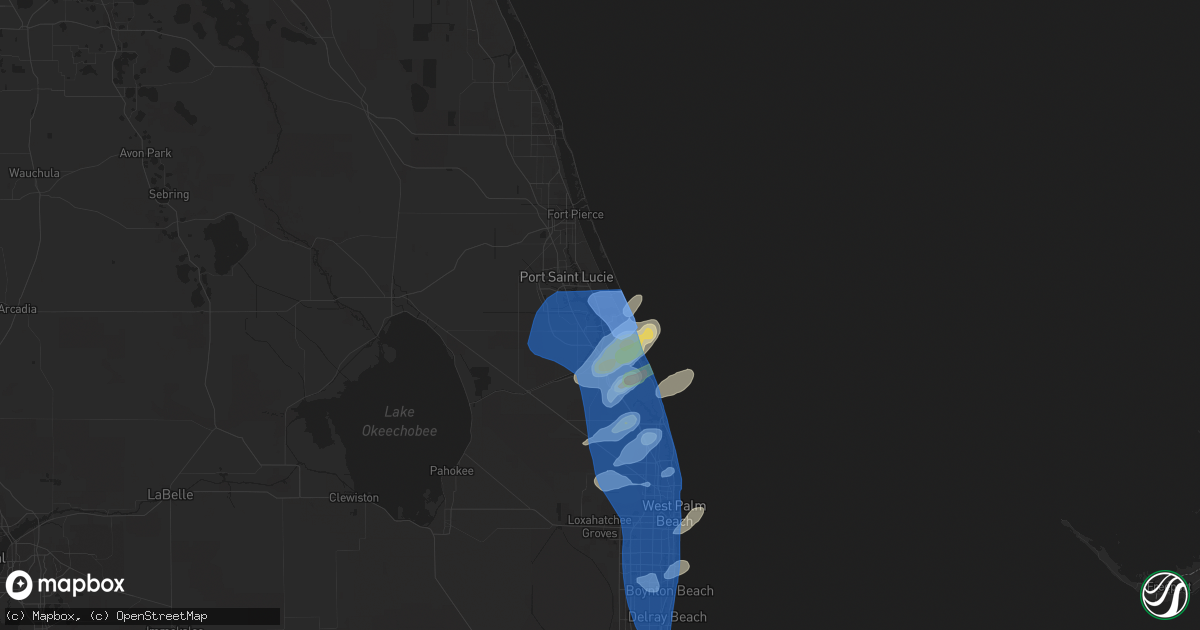
Hail Map in Stuart, FL on April 11, 2021
Get this storm
April 11 map
$229
one time, instant access
Download today. No call, no setup
Keep the $229
Bought the map and want the full workflow? Apply the entire $229 to a subscription within 7 days. None of it is wasted.
Every map, not just this one
This buys you this map. Subscription and you get every map we run, in the markets you choose from a few cities to whole states to nationwide. Plus real-time alerts the moment a storm fires.
Contact data
Name, contact info, occupancy, even credit band for addresses in the footprint. You go from where it hit to who to call.
Become the source they trust
Unlimited branding weather history reports on demand. You already have the documented answer ready for the property owner, and you are the one who showed up with it.
Property data and RoofTrace estimates
Pull up any address you have got, its value and the exact code rules for that jurisdiction, straight from One Click Code. Then RoofTrace estimates the squares, pitch, and roof value, priced the way you price.
Storm reports in Stuart, FL
Stuart, FL
| Date | Description |
|---|---|
| 04/11/20211:54 PM CDT | Trained spotter measured a peak wind gust of 68mph/59kt at rocky point near stuart. Peak sustained wind was 38mph. |
| 04/11/20211:52 PM CDT | A trained spotter reported numerous downed branches that were 4-5 inches in diameter... Near sewall point. |
| 04/11/20211:52 PM CDT | Local broadcast media reported a very large tree was knocked down on a property near se st. Lucie blvd in stuart... Just south of the airport and golf course. Time is e |
| 04/11/20211:50 PM CDT | The awos at stuart witham field measured a peak wind gust of 55kt/63mph from the nw. |
All Cities Impacted by Hail Map on April 11, 2021
- Indiantown, FL
- Hobe Sound, FL
- Ochlocknee, GA
- Whigham, GA
- Cairo, GA
- Zolfo Springs, FL
- Stuart, FL
- Beaumont, TX
- Largo, FL
- Norfolk, VA
- Blountstown, FL
- Bristol, FL
- Bowling Green, FL
- Jupiter, FL
- Palm Beach Gardens, FL
- Oviedo, FL
- Casselberry, FL
- Winter Park, FL
- Orlando, FL
- Maitland, FL
- Okeechobee, FL
- Chambersburg, PA
- Fort Meade, FL
- Vidor, TX
- Port Neches, TX
- Nederland, TX
- Port Arthur, TX
- Sebring, FL
- Fort Lauderdale, FL
- Lorida, FL
- Brooksville, FL
- Portsmouth, VA
- Parrish, FL
- Lutz, FL
- Gotha, FL
- Winter Springs, FL
- Windermere, FL
- Mims, FL
- Ona, FL
- Lakeland, FL
- Tampa, FL
- Red Lion, PA
- Windsor, PA
- Felton, PA
- Wellington, FL
- Loxahatchee, FL
- Valrico, FL
- Dover, FL
- Plant City, FL
- Wauchula, FL
- Lake Worth, FL
- Boynton Beach, FL
- Christmas, FL
- Clearwater, FL
- Moore Haven, FL
- Groves, TX
- Cameron, LA
- Sabine Pass, TX
- Newburg, PA
- Palm Beach, FL
- Coldspring, TX
- Cleveland, TX
- Hialeah, FL
- Newport News, VA
- Lithia, FL
- Lake Placid, FL
- Venus, FL
- Shippensburg, PA
- Fayetteville, PA
- Myakka City, FL
- West Palm Beach, FL
- Opa Locka, FL
- Wesley Chapel, FL
- Newville, PA
- North Palm Beach, FL
- Brandon, FL
- Seffner, FL
- Hollywood, FL
- Geneva, FL
- Altamonte Springs, FL
- Longwood, FL
- Grant, FL
- Melbourne Beach, FL
- Vero Beach, FL
- Malabar, FL
- Sebastian, FL
- Jensen Beach, FL
- Port Saint Lucie, FL
- Fort Pierce, FL
- Boca Raton, FL
- Lake Worth Beach, FL
- Pompano Beach, FL
- Delray Beach, FL
- Palm City, FL
- Deerfield Beach, FL
- Odessa, FL
- Oldsmar, FL
- Tarpon Springs, FL
- Holiday, FL
- New Port Richey, FL
- Crystal Beach, FL
- Palm Harbor, FL
- Zephyrhills, FL
- Land O'Lakes, FL
- Thonotosassa, FL
- Fellsmere, FL


