Hail Map in Kansas on April 11, 2020
Get this storm
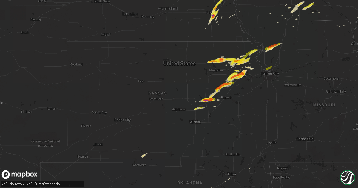
April 11 map
$229
one time, instant access
Download today. No call, no setup
Keep the $229
Bought the map and want the full workflow? Apply the entire $229 to a subscription within 7 days. None of it is wasted.
Every map, not just this one
This buys you this map. Subscription and you get every map we run, in the markets you choose from a few cities to whole states to nationwide. Plus real-time alerts the moment a storm fires.
Contact data
Name, contact info, occupancy, even credit band for addresses in the footprint. You go from where it hit to who to call.
Become the source they trust
Unlimited branding weather history reports on demand. You already have the documented answer ready for the property owner, and you are the one who showed up with it.
Property data and RoofTrace estimates
Pull up any address you have got, its value and the exact code rules for that jurisdiction, straight from One Click Code. Then RoofTrace estimates the squares, pitch, and roof value, priced the way you price.
Storm reports in Kansas
Kansas
| Date | Description |
|---|---|
| 04/11/20206:54 PM CDT | Golfball size hail covering the ground. |
| 04/11/20206:37 PM CDT | Report with picture came in via social media. |
| 04/11/20206:33 PM CDT | . |
| 04/11/20206:23 PM CDT | . |
| 04/11/20206:21 PM CDT | . |
| 04/11/20206:18 PM CDT | Picture sent via twitter. |
| 04/11/20206:58 AM CDT | At 1157 PM CDT, a severe thunderstorm was located near Olsburg, moving northeast at 15 mph. HAZARD...60 mph wind gusts and quarter size hail. SOURCE...Trained weather spotters. IMPACT...Hail damage to vehicles is expected. Expect wind damage to roofs, siding, and trees. Locations impacted include... Blaine and Olsburg. |
| 04/11/20206:22 AM CDT | At 1121 PM CDT, a severe thunderstorm was located near Olsburg, moving east at 15 mph. HAZARD...Ping pong ball size hail and 60 mph wind gusts. SOURCE...Radar indicated. At 1118 PM CDT...trained spotters reported quarter size hail near Olsburg. IMPACT...People and animals outdoors will be injured. Expect hail damage to roofs, siding, windows, and vehicles. Expect wind damage to roofs, siding, and trees. Locations impacted include... Westmoreland and Olsburg. |
| 04/11/20206:20 AM CDT | At 1119 PM CDT, a severe thunderstorm was located near Circleville, moving southeast at 15 mph. HAZARD...60 mph wind gusts and half dollar size hail. SOURCE...Radar indicated. IMPACT...Hail damage to vehicles is expected. Expect wind damage to roofs, siding, and trees. Locations impacted include... Holton, Mayetta, Denison and Potawatomi Reservation. |
| 04/11/20205:57 AM CDT | At 1056 PM CDT, severe thunderstorms were located along a line extending from near Circleville to 3 miles north of Randolph, moving east at 45 mph. HAZARD...60 mph wind gusts and half dollar size hail. SOURCE...Radar indicated. These storms have had a history of ping pong ball size hail near Randolph at 1040 PM. IMPACT...Hail damage to vehicles is expected. Expect wind damage to roofs, siding, and trees. Locations impacted include... Holton, Blaine, Onaga, Wetmore, Olsburg, Whiting, Circleville, Randolph, Netawaka, Soldier, Havensville, Wheaton and Lillis. |
| 04/11/20205:17 AM CDT | At 1017 PM CDT, a severe thunderstorm was located near Denison, or 9 miles northwest of Valley Falls, moving northeast at 30 mph. HAZARD...60 mph wind gusts and quarter size hail. SOURCE...Radar indicated. IMPACT...Hail damage to vehicles is expected. Expect wind damage to roofs, siding, and trees. Locations impacted include... Atchison, Effingham, Lancaster, Muscotah, Farmington, Huron, Arrington and Cummings. |
| 04/11/20205:16 AM CDT | At 1015 PM CDT, severe thunderstorms were located along a line extending from 5 miles northwest of Randolph to near Muscotah, moving northeast at 35 mph. HAZARD...Half dollar size hail and wind gusts up to 50 mph. SOURCE...Radar indicated. IMPACT...Damage to vehicles is expected. Locations impacted include... Holton, Horton, Blue Rapids, Westmoreland, Blaine, Onaga, Wetmore, Everest, Olsburg, Whiting, Circleville, Randolph, Corning, Netawaka, Soldier, Havensville, Goff, Wheaton, Kickapoo Reservation and Lillis. |
| 04/11/20204:40 AM CDT | At 939 PM CDT, a severe thunderstorm was located 5 miles northeast of Emmett, moving east at 30 mph. HAZARD...60 mph wind gusts and quarter size hail. SOURCE...Radar indicated. IMPACT...Hail damage to vehicles is expected. Expect wind damage to roofs, siding, and trees. Locations impacted include... Holton, Hoyt, Mayetta, Denison, Delia and Potawatomi Reservation. |
| 04/11/20203:27 AM CDT | At 826 PM CDT, a severe thunderstorm was located near Willard, moving northeast at 45 mph. HAZARD...Golf ball size hail and 60 mph wind gusts. SOURCE...Radar indicated. IMPACT...People and animals outdoors will be injured. Expect hail damage to roofs, siding, windows, and vehicles. Expect wind damage to roofs, siding, and trees. Locations impacted include... Northern Topeka, Rossville, Silver Lake, Hoyt, Maple Hill, Mayetta, Delia and Willard.This includes Interstate 70 between mile markers 342 and 351. |
| 04/11/20203:11 AM CDT | At 811 PM CDT, a severe thunderstorm was located near Denison, or near Holton, moving east at 30 mph. HAZARD...Ping pong ball size hail and 60 mph wind gusts. SOURCE...Radar indicated. IMPACT...People and animals outdoors will be injured. Expect hail damage to roofs, siding, windows, and vehicles. Expect wind damage to roofs, siding, and trees. Locations impacted include... Atchison, Effingham, Lancaster, Muscotah, Farmington, Huron, Arrington and Cummings. |
| 04/11/20203:09 AM CDT | At 808 PM CDT, a severe thunderstorm was located over Lake Waukomis, or near Gladstone, moving northeast at 40 mph. HAZARD...60 mph wind gusts and quarter size hail. SOURCE...Radar indicated. IMPACT...Hail damage to vehicles is expected. Expect wind damage to roofs, siding, and trees. Locations impacted include... Kansas City, Liberty, Gladstone, Smithville, Kearney, Parkville, Riverside, Weatherby Lake, Claycomo, Pleasant Valley, Lake Waukomis, Glenaire, Platte Woods, Oakview, Northmoor, Missouri City, Houston Lake, River Bend, Mosby and Oakwood Park.This includes the following highways... Interstate 35 in Missouri between mile markers 8 and 28. Interstate 29 between mile markers 0 and 10. Interstate 635 between mile markers 9 and 12. Interstate 435 between mile markers 38 and 54. |
| 04/11/20203:09 AM CDT | At 809 PM CDT, a severe thunderstorm was located near Eskridge, moving northeast at 40 mph. HAZARD...60 mph wind gusts and half dollar size hail. SOURCE...Radar indicated. IMPACT...Hail damage to vehicles is expected. Expect wind damage to roofs, siding, and trees. Locations impacted include... Northwestern Topeka, Eskridge, Dover, Auburn, Burlingame, Scranton, Harveyville and Keene.This includes the following highways... Interstate 70 between mile markers 349 and 355. Kansas Turnpike between mile markers 155 and 174. |
| 04/11/20203:04 AM CDT | At 803 PM CDT, a severe thunderstorm was located near Holton, moving northeast at 35 mph. HAZARD...60 mph wind gusts and half dollar size hail. SOURCE...Radar indicated. IMPACT...Hail damage to vehicles is expected. Expect wind damage to roofs, siding, and trees. Locations impacted include... Holton, Mayetta and Denison. |
| 04/11/20202:56 AM CDT | At 756 PM CDT, a severe thunderstorm was located over northwestern Topeka, moving northeast at 45 mph. HAZARD...Tennis ball size hail and 60 mph wind gusts. SOURCE...Radar indicated. IMPACT...People and animals outdoors will be injured. Expect hail damage to roofs, siding, windows, and vehicles. Expect wind damage to roofs, siding, and trees. Locations impacted include... Valley Falls, Oskaloosa, Tecumseh, Perry, McLouth, Meriden, Ozawkie, Nortonville, Lecompton, Winchester, Williamstown, Perry Lake and Grantville.This includes Kansas Turnpike between mile markers 183 and 193. |
| 04/11/20202:40 AM CDT | At 739 PM CDT, a severe thunderstorm was located near Dover, moving northeast at 45 mph. HAZARD...Two inch hail and 60 mph wind gusts. SOURCE...Radar indicated. IMPACT...People and animals outdoors will be injured. Expect hail damage to roofs, siding, windows, and vehicles. Expect wind damage to roofs, siding, and trees. Locations impacted include... Topeka, Tecumseh, Dover, Silver Lake, Auburn, Hoyt, Willard and Pauline.This includes the following highways... Interstate 70 between mile markers 345 and 355. Kansas Turnpike between mile markers 167 and 188. |
| 04/11/20202:35 AM CDT | At 735 PM CDT, a severe thunderstorm was located over Harveyville, moving northeast at 35 mph. HAZARD...Ping pong ball size hail and 60 mph wind gusts. SOURCE...Radar indicated. IMPACT...People and animals outdoors will be injured. Expect hail damage to roofs, siding, windows, and vehicles. Expect wind damage to roofs, siding, and trees. Locations impacted include... Southern Topeka, Carbondale, Richland, Overbrook, Burlingame, Scranton, Harveyville, Berryton and Pomona Lake.This includes Kansas Turnpike between mile markers 150 and 166. |
| 04/11/20202:03 AM CDT | At 703 PM CDT, a severe thunderstorm was located 7 miles northeast of Council Grove, moving northeast at 45 mph. HAZARD...Two inch hail and 60 mph wind gusts. SOURCE...Radar indicated. IMPACT...People and animals outdoors will be injured. Expect hail damage to roofs, siding, windows, and vehicles. Expect wind damage to roofs, siding, and trees. Locations impacted include... Eskridge, Maple Hill and Keene. This includes Interstate 70 between mile markers 338 and 345. |
| 04/11/20201:54 AM CDT | At 654 PM CDT, a severe thunderstorm was located 7 miles northeast of Florence, moving east at 15 mph. HAZARD...Golf ball size hail and 60 mph wind gusts. SOURCE...Radar indicated. IMPACT...People and animals outdoors will be injured. Expect hail damage to roofs, siding, windows, and vehicles. Expect wind damage to roofs, siding, and trees. Locations impacted include... Peabody, Cottonwood Falls, Strong City, Florence, Elbing, Burns, Cassoday, Bazaar, Elmdale, Matfield Green, Cedar Point, Hymer, Wonsevu, Tallgrass Prairie, Saffordville and Tallgrass Prairie Preserve.This includes Interstate 35 between Mile Markers 86 and 115. |
| 04/11/20201:49 AM CDT | At 649 PM CDT, a severe thunderstorm was located 4 miles south of Council Grove, moving northeast at 35 mph. HAZARD...Golf ball size hail and 60 mph wind gusts. SOURCE...Radar indicated. IMPACT...People and animals outdoors will be injured. Expect hail damage to roofs, siding, windows, and vehicles. Expect wind damage to roofs, siding, and trees. Locations impacted include... Council Grove, Bushong, Dunlap and Council Grove Lake. |
| 04/11/20201:25 AM CDT | At 624 PM CDT, a severe thunderstorm was located 8 miles southeast of Burdick, moving northeast at 35 mph. HAZARD...60 mph wind gusts and half dollar size hail. SOURCE...Radar indicated. IMPACT...Hail damage to vehicles is expected. Expect wind damage to roofs, siding, and trees. Locations impacted include... Wilsey and Dunlap. |
| 04/11/202012:55 AM CDT | At 554 PM CDT, a severe thunderstorm was located over Marion, moving east at 30 mph. HAZARD...60 mph wind gusts and half dollar size hail. SOURCE...Radar indicated. IMPACT...Hail damage to vehicles is expected. Expect wind damage to roofs, siding, and trees. Locations impacted include... Hillsboro, Marion, Peabody, Cottonwood Falls, Strong City, Florence, Burns, Lincolnville, Bazaar, Elmdale, Matfield Green, Cedar Point, Hymer, Marion Lake, Wonsevu, Tallgrass Prairie, Saffordville and Tallgrass Prairie Preserve.This includes Interstate 35 between Mile Markers 97 and 115. |
| 04/10/202011:35 PM CDT | Mostly nickels and a few quarters. |
| 04/10/202011:23 PM CDT | A local report indicates 1.25 inch wind near 3 S CIRCLEVILLE |
| 04/10/202011:21 PM CDT | Hail covering the ground. |
| 04/10/202010:44 PM CDT | A local report indicates 1.50 inch wind near RANDOLPH |
| 04/10/202010:41 PM CDT | A local report indicates 1.00 inch wind near RANDOLPH |
| 04/10/202010:40 PM CDT | A local report indicates 1.50 inch wind near RANDOLPH |
| 04/10/202010:30 PM CDT | Golfball to tennis ball sized hail. Lasted for 20 minutes. |
| 04/10/20208:40 PM CDT | A local report indicates 1.00 inch wind near EFFINGHAM |
| 04/10/20208:37 PM CDT | . |
| 04/10/20208:37 PM CDT | . |
| 04/10/20208:32 PM CDT | Pea to dime sized hail with a few quarters. Also 50 mph wind gusts. |
| 04/10/20208:12 PM CDT | 66th and clark road. |
| 04/10/20208:07 PM CDT | Report from mping: quarter |
| 04/10/20208:06 PM CDT | . |
| 04/10/20208:06 PM CDT | K-4 hwy and 62nd street. |
| 04/10/20208:06 PM CDT | Corrects previous hail report. |
| 04/10/20208:06 PM CDT | K-4 and 54th street. |
| 04/10/20208:04 PM CDT | . |
| 04/10/20208:00 PM CDT | At nws topeka at billard airport. |
| 04/10/20207:56 PM CDT | . |
| 04/10/20207:54 PM CDT | At 33rd and wanamaker. |
| 04/10/20207:54 PM CDT | Report from mping: half dollar |
| 04/10/20207:53 PM CDT | Via twitter. |
| 04/10/20207:53 PM CDT | Report from mping: quarter |
| 04/10/20207:50 PM CDT | Quarter size hail at wibw. |
| 04/10/20207:49 PM CDT | Most half dollar size with a few golf ball sized. |
| 04/10/20207:49 PM CDT | Report from mping: ping pong ball |
| 04/10/20207:48 PM CDT | . |
| 04/10/20207:47 PM CDT | . |
| 04/10/20207:46 PM CDT | . |
| 04/10/20207:22 PM CDT | Kake sent picture sent via twitter. |
| 04/10/20207:20 PM CDT | Kake sent report of two inch hail. Time was estimated from radar. |
| 04/10/20207:15 PM CDT | . |
| 04/10/20207:05 PM CDT | . |
All States Impacted by Hail Map on April 11, 2020
Cities Impacted by Hail Map on April 11, 2020
- Scribner, NE
- Randlett, OK
- Stewartsville, MO
- Easton, MO
- Clarksdale, MO
- Laughlin Afb, TX
- Del Rio, TX
- Elmer, OK
- Duke, OK
- Gould, OK
- Wynnewood, OK
- Duncan, OK
- Foster, OK
- Tussy, OK
- Temple, OK
- Indiahoma, OK
- Comanche, OK
- Vernon, TX
- Walters, OK
- Hennepin, OK
- Geronimo, OK
- Frederick, OK
- Loveland, OK
- Headrick, OK
- Odell, TX
- Tipton, OK
- Cache, OK
- Lawton, OK
- Faxon, OK
- Sulphur, OK
- Eldorado, OK
- Chattanooga, OK
- Marlow, OK
- Olustee, OK
- Davis, OK
- Altus, OK
- Elmore City, OK
- Ratliff City, OK
- Lineville, IA
- Topeka, KS
- Avoca, TX
- Hamlin, TX
- Stamford, TX
- Breckenridge, TX
- Abilene, TX
- Roby, TX
- Lueders, TX
- Anson, TX
- Sylvester, TX
- Albany, TX
- Woodson, TX
- Sweetwater, TX
- McCaulley, TX
- Sterling City, TX
- Russell, IA
- Chariton, IA
- Corydon, IA
- Melrose, IA
- Bendena, KS
- Denton, KS
- Lancaster, KS
- Troy, KS
- Ozawkie, KS
- Oskaloosa, KS
- Midland, TX
- Lovilia, IA
- Ralls, TX
- Tecumseh, KS
- Grantville, KS
- Meriden, KS
- Childress, TX
- Barksdale, TX
- Big Spring, TX
- Garden City, TX
- Uvalde, TX
- Knippa, TX
- Sabinal, TX
- Colorado City, TX
- Mooreland, OK
- Onaga, KS
- Brackettville, TX
- Aspermont, TX
- Old Glory, TX
- Rule, TX
- Leakey, TX
- Council Grove, KS
- Florence, KS
- Marion, KS
- Strong City, KS
- Elmdale, KS
- Cedar Point, KS
- Unadilla, NE
- Palmyra, NE
- Dawson, TX
- Ozona, TX
- Rocksprings, TX
- Osceola, IA
- Troup, TX
- Arp, TX
- Penelope, TX
- Snyder, TX
- Whiting, KS
- Netawaka, KS
- Valley Falls, KS
- Coahoma, TX
- Westbrook, TX
- Memphis, TX
- Paint Rock, TX
- Wall, TX
- Vancourt, TX
- San Angelo, TX
- Eola, TX
- Unionville, IA
- Rocky, OK
- Franklin, IL
- Henderson, TX
- Price, TX
- Gatesville, TX
- Oglesby, TX
- McGregor, TX
- Rush Springs, OK
- Lometa, TX
- Crane, TX
- Wellington, TX
- Tell, TX
- Stratford, OK
- Ada, OK
- Jayton, TX
- Fort Stockton, TX
- Winchester, IL
- Murrayville, IL
- Maysville, MO
- Amity, MO
- Camp Wood, TX
- Hunt, TX
- Haskell, TX
- Westmoreland, KS
- North Newton, KS
- Newton, KS
- Ceresco, NE
- Waterloo, NE
- Yutan, NE
- Ashland, NE
- Ithaca, NE
- Holton, KS
- Soldier, KS
- Havensville, KS
- Mayetta, KS
- Denison, KS
- Circleville, KS
- Mertzon, TX
- Delia, KS
- Weinert, TX
- Ardmore, OK
- Crosbyton, TX
- Gail, TX
- Lampasas, TX
- Bennet, NE
- La Harpe, IL
- Blandinsville, IL
- Dallas City, IL
- Niota, IL
- Brickeys, AR
- Denton, TX
- Ponder, TX
- Rhome, TX
- Justin, TX
- Decatur, TX
- Krum, TX
- Alta Vista, KS
- Allen, KS
- Alma, KS
- Eskridge, KS
- Harveyville, KS
- Lucas, IA
- Woodburn, IA
- Weldon, IA
- Humeston, IA
- Van Wert, IA
- Leon, IA
- Wathena, KS
- Matador, TX
- Tennessee Colony, TX
- Montalba, TX
- Junction, TX
- Mason, TX
- Buffalo, OK
- Vinson, OK
- Kahoka, MO
- Pryor, OK
- Arbela, MO
- Coolidge, TX
- Prairie Hill, TX
- Electra, TX
- Elgin, OK
- Springer, OK
- Roff, OK
- Ringling, OK
- Healdton, OK
- Mangum, OK
- Davidson, OK
- Grandfield, OK
- Hollister, OK
- Graham, OK
- Graham, TX
- Graford, TX
- Lohn, TX
- Eden, TX
- Eldorado, TX
- Christoval, TX
- Doole, TX
- Melvin, TX
- McLouth, KS
- Silver Lake, KS
- Lakeview, TX
- Dodson, TX
- China Spring, TX
- Waco, TX
- Valley Mills, TX
- Crawford, TX
- West, TX
- Woodway, TX
- Quanah, TX
- Perry, KS
- Memphis, NE
- Martell, NE
- Clatonia, NE
- Elkhorn, NE
- Lincoln, NE
- Gretna, NE
- Waverly, NE
- Roca, NE
- Walton, NE
- Greenwood, NE
- Sprague, NE
- Hallam, NE
- Hermleigh, TX
- Comstock, TX
- Roosevelt, OK
- Tulia, TX
- Silverton, TX
- Wilson, OK
- Derby, IA
- Garden Grove, IA
- Kerrville, TX
- Fredericksburg, TX
- Stonewall, OK
- Rotan, TX
- Menard, TX
- Cordell, OK
- Valley Spring, TX
- Art, TX
- Pontotoc, TX
- Burnet, TX
- Tow, TX
- Lone Wolf, OK
- Auburn, IL
- Horton, KS
- Muscotah, KS
- Hubbard, TX
- Kellerton, IA
- Lamoni, IA
- Gotebo, OK
- Tyler, TX
- Goodfellow Afb, TX
- Miles, TX
- Llano, TX
- Vermillion, KS
- Leonardville, KS
- Effingham, KS
- Olsburg, KS
- Nortonville, KS
- Randolph, KS
- Emmett, KS
- Perrin, TX
- Mountain Park, OK
- Castell, TX
- Maple Hill, KS
- Wilsey, KS
- Oakland, NE
- Apache, OK
- Creston, NE
- Leigh, NE
- Bridgeport, TX
- Paradise, TX
- Big Lake, TX
- Saint Joseph, MO
- Agency, MO
- Imperial, TX
- Mystic, IA
- Plano, IA
- Burns, KS
- Tabor, IA
- Overton, TX
- Columbus, NE
- Taylorville, IL
- Boyd, TX
- Dickens, TX
- Marshall, TX
- Tatum, TX
- Jacksonville, IL
- Alexander, IL
- De Valls Bluff, AR
- Divernon, IL
- Loami, IL
- Chatham, IL
- Waverly, IL
- Walton, KS
- Afton, TX
- Mount Ayr, IA
- Fluvanna, TX
- Paducah, TX
- Stanton, TX
- Belton, TX
- Sonora, TX
- Mountain Home, TX
- Cherokee, TX
- Turkey, TX
- Woodson, IL
- Adams, NE
- Firth, NE
- Lorena, TX
- Council Bluffs, IA
- Nebraska City, NE
- Union, NE
- Murray, IA
- Grant City, MO
- Hickman, NE
- Cee Vee, TX
- Auburn, KS
- Berryton, KS
- San Saba, TX
- Clarkson, NE
- Schuyler, NE
- Cottonwood Falls, KS
- Mount Calm, TX
- Axtell, TX
- Oak Grove, MO
- Grain Valley, MO
- Waurika, OK
- Bedford, IA
- Loco, OK
- Killeen, TX
- Ballinger, TX
- Mexia, TX
- Tovey, IL
- Kincaid, IL
- Glenarm, IL
- Pawnee, IL
- Ryan, OK
- Rochelle, TX
- Brookesmith, TX
- Ingram, TX
- Hobart, OK
- Midkiff, TX
- Garrison, TX
- Troy, TX
- Allerton, IA
- Luray, MO
- De Witt, NE
- Elm Mott, TX
- Memphis, MO
- Belvue, KS
- Wamego, KS
- Ninnekah, OK
- Wakarusa, KS
- Granger, TX
- Bartlett, TX
- Peabody, KS
- Hamilton, IL
- Willow City, TX
- Hillsboro, KS
- Blanchard, OK
- Springtown, TX
- Freedom, OK
- Miami, FL
- Briggs, TX
- Corsicana, TX
- Barry, TX
- Jacksboro, TX
- Mountain View, OK
- Throckmorton, TX
- Mcadoo, TX
- Fort Madison, IA
- Wortham, TX
- Emporia, KS
- Argyle, TX
- Kellyville, OK
- Stroud, OK
- Winchester, KS
- Fairfield, TX
- Streetman, TX
- Anna, TX
- Fletcher, OK
- Round Mountain, TX
- Platte Center, NE
- Longview, TX
- Aubrey, TX
- Celina, TX
- Sapulpa, OK
- Tulsa, OK
- Harper, TX
- Dunbar, NE
- Alvo, NE
- Davey, NE
- Flomot, TX
- Good Hope, IL
- Sciota, IL
- Hollis, OK
- Mereta, TX
- Plainview, TX
- Matfield Green, KS
- McCamey, TX
- Purdon, TX
- Princeton, MO
- Buchanan Dam, TX
- Moody, TX
- Hoyt, KS
- Depew, OK
- Bristow, OK
- Homestead, FL
- Newark, TX
- Frost, TX
- Moravia, IA
- Winston, MO
- Cosby, MO
- Osborn, MO
- Weatherby, MO
- Carnegie, OK
- Hughes, AR
- Kempner, TX
- Medicine Park, OK
- Bend, TX
- Granite, OK
- Quail, TX
- Parks, AR
- Udell, IA
- Centerville, IA
- Waskom, TX
- Karnack, TX
- Cortland, NE
- Mart, TX
- Carlsbad, TX
- Georgetown, TX
- Copperas Cove, TX
- Concan, TX
- Santa Anna, TX
- Rockwood, TX
- Riesel, TX
- Teague, TX
- Athens, TX
- Groesbeck, TX
- Malone, TX
- Malakoff, TX
- Powell, TX
- Trinidad, TX
- Kerens, TX
- Danville, AR
- Greenwood, AR
- Huntington, AR
- Booneville, AR
- Havana, AR
- Belleville, AR
- Ola, AR
- Mansfield, AR
- Ozark, AR
- Clarksville, AR
- Hartman, AR
- Altus, AR
- Coal Hill, AR
- Casa, AR
- Morrilton, AR
- Adona, AR
- Atkins, AR
- Malvern, AR
- Hot Springs National Park, AR
- Pearcy, AR
- Bonnerdale, AR
- Benton, AR
- Traskwood, AR
- Prattsville, AR
- Leola, AR
- Sheridan, AR
- Wabbaseka, AR
- Humphrey, AR
- Sherrill, AR
- Stuttgart, AR
- Altheimer, AR
- White Hall, AR
- Tucker, AR
- Hensley, AR
- England, AR
- Humnoke, AR
- Little Rock, AR
- Mabelvale, AR
- Jefferson, AR
- Redfield, AR
- De Witt, AR
- Almyra, AR
- Saint Charles, AR
- Tunica, MS
- Holly Grove, AR
- Friars Point, MS
- Coldwater, MS
- Coahoma, MS
- Mellwood, AR
- Ethel, AR
- Dundee, MS
- West Helena, AR
- Elaine, AR
- Crumrod, AR
- Helena, AR
- Clarksdale, MS
- Pine Bluff, AR
- Grady, AR
- Rison, AR
- Kingsland, AR
- New Edinburg, AR
- Dumas, AR
- Star City, AR
- Wilmar, AR
- Carlisle, AR
- Ulm, AR
- Roe, AR
- Hazen, AR
- Marianna, AR
- Robinsonville, MS
- Nesbit, MS
- Hernando, MS
- Brinkley, AR
- Moro, AR
- Forrest City, AR
- Palestine, AR
- Colt, AR
- Widener, AR
- Heth, AR
- Sarah, MS
- Sledge, MS
- Crenshaw, MS
- Senatobia, MS
- Lyon, MS
- Marks, MS
- Batesville, MS
- Courtland, MS
- Charleston, MS
- Lambert, MS
- Tutwiler, MS
- Enid, MS
- Oakland, MS
- Cascilla, MS
- Tillatoba, MS
- Earle, AR
- Spicewood, TX
- Leander, TX
- Johnson City, TX
- Marble Falls, TX
- Altus Afb, OK
- Snyder, OK
- Burlingame, KS
- Everest, KS
- Paxico, KS
- Rossville, KS
- Kansas City, MO
- Albia, IA


