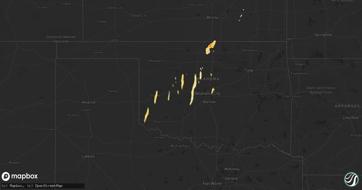
Hail Map in Oklahoma on April 10, 2023
Get this storm
April 10 map
$229
one time, instant access
Download today. No call, no setup
Keep the $229
Bought the map and want the full workflow? Apply the entire $229 to a subscription within 7 days. None of it is wasted.
Every map, not just this one
This buys you this map. Subscription and you get every map we run, in the markets you choose from a few cities to whole states to nationwide. Plus real-time alerts the moment a storm fires.
Contact data
Name, contact info, occupancy, even credit band for addresses in the footprint. You go from where it hit to who to call.
Become the source they trust
Unlimited branding weather history reports on demand. You already have the documented answer ready for the property owner, and you are the one who showed up with it.
Property data and RoofTrace estimates
Pull up any address you have got, its value and the exact code rules for that jurisdiction, straight from One Click Code. Then RoofTrace estimates the squares, pitch, and roof value, priced the way you price.
Storm reports in Oklahoma
Oklahoma
| Date | Description |
|---|---|
| 04/10/20236:56 PM CDT | From route 66 about 0.25 mile from the intersection with business 40 near el reno. Largest was ping pong balls. You are welcome nolan. |
| 04/10/20236:51 PM CDT | Twitter report with photo. Time is radar estimate. |
| 04/10/20236:51 PM CDT | Twitter report with photo. Time is radar estimated. |
| 04/10/20236:50 PM CDT | Some hailstones approaching 2 inches in diameter. |
| 04/10/20236:23 PM CDT | Twitter report with video. |
| 04/10/20236:13 PM CDT | Report from mping. |
| 04/10/20236:05 PM CDT | A local report indicates 1.50 inch wind near OKARCHE |
| 04/10/20235:36 PM CDT | A local report indicates 1.25 inch wind near 8 E VINSON |
| 04/10/20235:34 PM CDT | Report from mping. |
| 04/10/20235:30 PM CDT | Nwschat report. Between dover and crescent. |
| 04/10/20235:00 PM CDT | Twitter report... Time is radar estimate. |
| 04/10/20234:37 PM CDT | Hail slightly smaller than golfballs. Spotter right outside of watonga. Time is radar estimated. |
| 04/10/20234:30 PM CDT | Twitter report. Time is radar estimate. |
| 04/10/20234:06 PM CDT | Mping report. |
| 04/10/20234:05 PM CDT | Twitter report. |
| 04/09/20238:25 PM CDT | Twitter report. |
| 04/09/20238:10 PM CDT | Twitter report. |
| 04/09/20237:50 PM CDT | Nwschat relayed... Time is radar estimate. |
| 04/09/20237:50 PM CDT | Time estimated via radar. |
Cities Impacted by Hail Map on April 10, 2023
- Kansas City, MO
- Scott, OH
- Haviland, OH
- Van Wert, OH
- Convoy, OH
- Fontana, KS
- La Cygne, KS
- Burkett, TX
- Coleman, TX
- Santa Anna, TX
- Butler, OK
- Elk City, OK
- Canute, OK
- Thomas, OK
- Watonga, OK
- Hitchcock, OK
- Carter, OK
- Gouldbusk, TX
- Rockwood, TX
- Greenfield, OK
- Corn, OK
- Cordell, OK
- Lohn, TX
- Geary, OK
- Kingfisher, OK
- Hennessey, OK
- Dover, OK
- Amoret, MO
- Uvalde, TX
- Leakey, TX
- Amsterdam, MO
- Cross Plains, TX
- Brownwood, TX
- Camp Wood, TX
- Hartford, KS
- Oakwood, OK
- Centerville, KS
- Ottawa, KS
- Princeton, KS
- Riverside, MO
- Olathe, KS
- Clinton, OK
- Paola, KS
- Rantoul, KS
- Okeene, OK
- Osawatomie, KS
- Eureka, KS
- Hamilton, KS
- Mangum, OK
- Willow, OK
- Hydro, OK
- Mason, TX
- Melvin, TX
- Brady, TX
- Mulhall, OK
- Gould, OK
- Vinson, OK
- Guthrie, OK
- Coyle, OK
- Okarche, OK
- El Reno, OK
- Calumet, OK
- Jones, OK
- Minco, OK
- Union City, OK
- Spencer, OK
- Red Rock, OK
- Tonkawa, OK
- Stillwater, OK
- Arcadia, OK
- Perry, OK
- Luther, OK
- Meridian, OK
- Blackwell, OK
- Orlando, OK
- Geuda Springs, KS
- Braman, OK
- Newkirk, OK
- South Haven, KS
- Choctaw, OK
- Oklahoma City, OK
- Anadarko, OK
- Pocasset, OK
- Nardin, OK
- Deer Creek, OK
- Lamont, OK
- Hunter, OK
- Douglas, OK
- Marshall, OK
- Hunt, TX
- Piedmont, KS
- Medford, OK
- Vanderpool, TX
- Ingram, TX
- Mountain Home, TX
- Severy, KS
- Bison, OK
- Lenexa, KS
- Waverly, KS
- Shawnee, KS


