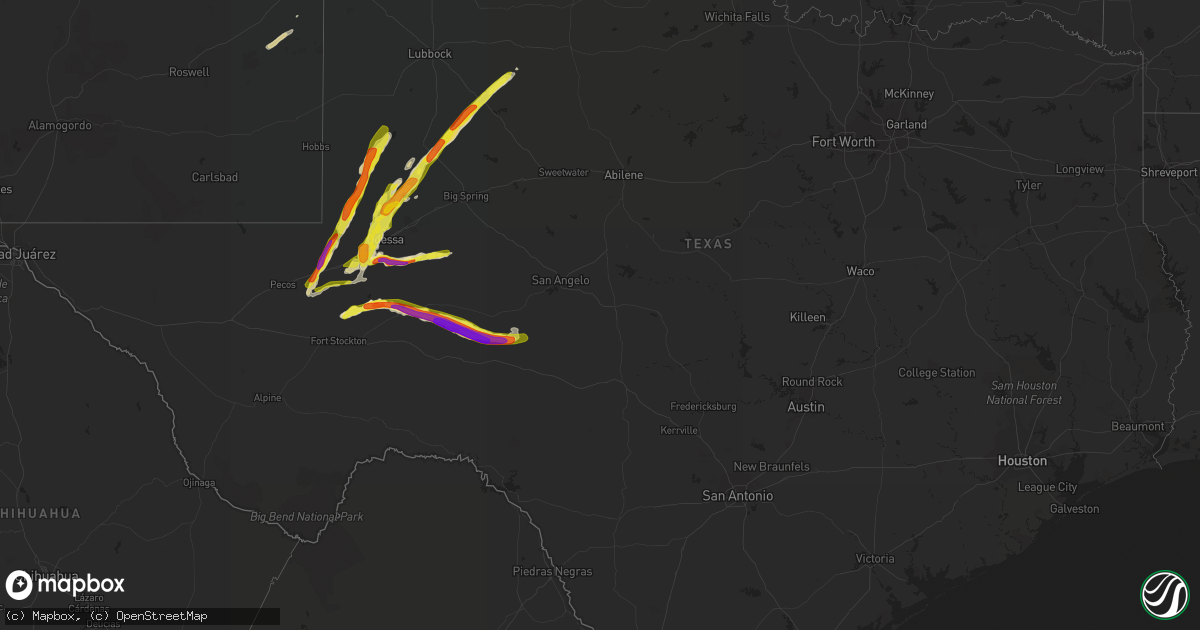
Hail Map in Texas on April 10, 2020
Get this storm
April 10 map
$229
one time, instant access
Download today. No call, no setup
Keep the $229
Bought the map and want the full workflow? Apply the entire $229 to a subscription within 7 days. None of it is wasted.
Every map, not just this one
This buys you this map. Subscription and you get every map we run, in the markets you choose from a few cities to whole states to nationwide. Plus real-time alerts the moment a storm fires.
Contact data
Name, contact info, occupancy, even credit band for addresses in the footprint. You go from where it hit to who to call.
Become the source they trust
Unlimited branding weather history reports on demand. You already have the documented answer ready for the property owner, and you are the one who showed up with it.
Property data and RoofTrace estimates
Pull up any address you have got, its value and the exact code rules for that jurisdiction, straight from One Click Code. Then RoofTrace estimates the squares, pitch, and roof value, priced the way you price.
Storm reports in Texas
Texas
| Date | Description |
|---|---|
| 04/10/20206:31 PM CDT | A local report indicates 2.75 inch wind near 11 SSW CRANE |
| 04/10/20206:30 PM CDT | Report relayed by local media |
| 04/10/20206:18 PM CDT | A local report indicates 1.00 inch wind near PYOTE |
| 04/10/20205:22 PM CDT | A local report indicates 1.50 inch wind near 9 S IMPERIAL |
| 04/10/20205:57 AM CDT | At 1056 PM CDT, a severe thunderstorm was located 17 miles northeast of Crane, moving east at 25 mph. HAZARD...Golf ball size hail and 60 mph wind gusts. SOURCE...Radar indicated. IMPACT...People and animals outdoors will be injured. Expect hail damage to roofs, siding, windows, and vehicles. Expect wind damage to roofs, siding, and trees. Locations impacted include... Midkiff. |
| 04/10/20205:17 AM CDT | At 1017 PM CDT, a severe thunderstorm was located 12 miles south of West Odessa, or 17 miles southwest of Odessa, moving east at 10 mph. HAZARD...Golf ball size hail and 60 mph wind gusts. SOURCE...Radar indicated. IMPACT...People and animals outdoors will be injured. Expect hail damage to roofs, siding, windows, and vehicles. Expect wind damage to roofs, siding, and trees. Locations impacted include... Far south Odessa and Pleasant Farms. |
| 04/10/20204:56 AM CDT | At 955 PM CDT, a severe thunderstorm was located 13 miles south of Barnhart, or 15 miles north of Ozona, moving east at 30 mph. HAZARD...Two inch hail and 60 mph wind gusts. SOURCE...Radar indicated. IMPACT...People and animals outdoors will be injured. Expect hail damage to roofs, siding, windows, and vehicles. Expect wind damage to roofs, siding, and trees. This severe thunderstorm will remain over mainly rural areas of southwestern Schleicher and northeastern Crockett Counties, including the following locations... Us-190 Near The Crockett-Sutton County Line, The Intersection Of Us-190 And Ranch Road 1828 and The Intersection Of Us 190 And Highway 163. |
| 04/10/20204:32 AM CDT | At 931 PM CDT, a severe thunderstorm was located 11 miles southeast of Kalgary, or 14 miles south of White River Lake, moving northeast at 40 mph. HAZARD...Golf ball size hail and 70 mph wind gusts. SOURCE...Radar indicated. IMPACT...People and animals outdoors will be injured. Expect hail damage to roofs, siding, windows, and vehicles. Expect considerable tree damage. Wind damage is also likely to mobile homes, roofs, and outbuildings. Locations impacted include... Spur, Dickens, White River Lake, Kalgary and Mcadoo. |
| 04/10/20203:55 AM CDT | At 854 PM CDT, a severe thunderstorm was located 11 miles south of Reagan County Airport, or 11 miles southwest of Big Lake, moving east at 25 mph. This is a very dangerous storm. HAZARD...Baseball size hail and 60 mph wind gusts. SOURCE...Radar indicated. IMPACT...People and animals outdoors will be severely injured. Expect shattered windows, extensive damage to roofs, siding, and vehicles. This severe thunderstorm will remain over mainly rural areas of northeastern Crockett County, including the following locations... The Intersection Of Us 190 And Highway 163. |
| 04/10/20203:42 AM CDT | At 842 PM CDT, a severe thunderstorm was located 11 miles north of Gail, moving northeast at 40 mph. HAZARD...Golf ball size hail and 70 mph wind gusts. SOURCE...Radar indicated. IMPACT...People and animals outdoors will be injured. Expect hail damage to roofs, siding, windows, and vehicles. Expect considerable tree damage. Wind damage is also likely to mobile homes, roofs, and outbuildings. Locations impacted include... Post, Lake Alan Henry and Justiceburg. |
| 04/10/20203:36 AM CDT | At 836 PM CDT, a severe thunderstorm was located 10 miles east of Gaines County Airport, or 11 miles southeast of Seminole, moving north at 30 mph. This storm has a history of producing large hail. HAZARD...Golf ball size hail and 60 mph wind gusts. SOURCE...Radar indicated. IMPACT...People and animals outdoors will be injured. Expect hail damage to roofs, siding, windows, and vehicles. Expect wind damage to roofs, siding, and trees. Locations impacted include... Seminole, Seagraves, Seagraves Airport, Gaines County Airport, Loop, McKenzie Lake and Gaines County Park. |
| 04/10/20203:19 AM CDT | At 818 PM CDT, a severe thunderstorm was located 9 miles southwest of Texon, or 12 miles southeast of Rankin, moving east at 15 mph. HAZARD...Golf ball size hail and 60 mph wind gusts. SOURCE...Radar indicated. IMPACT...People and animals outdoors will be injured. Expect hail damage to roofs, siding, windows, and vehicles. Expect wind damage to roofs, siding, and trees. This severe thunderstorm will remain over mainly rural areas of north central Crockett County west of State Highway 137. |
| 04/10/20202:53 AM CDT | At 752 PM CDT, a severe thunderstorm was located near Rankin, moving east at 20 mph. HAZARD...Golf ball size hail and 60 mph wind gusts. SOURCE...Law enforcement. IMPACT...People and animals outdoors will be injured. Expect hail damage to roofs, siding, windows, and vehicles. Expect wind damage to roofs, siding, and trees. Locations impacted include... Rankin and Best. |
| 04/10/20202:49 AM CDT | At 749 PM CDT, a severe thunderstorm was located 11 miles southwest of Andrews, moving north at 45 mph. HAZARD...60 mph wind gusts and quarter size hail. SOURCE...Radar indicated. IMPACT...Hail damage to vehicles is expected. Expect wind damage to roofs, siding, and trees. Locations impacted include... Andrews, Florey, Frankel City and Andrews County Airport. |
| 04/10/20202:26 AM CDT | At 726 PM CDT, a severe thunderstorm was located 12 miles west of Lenorah, or 22 miles north of Midland, moving northeast at 40 mph. HAZARD...60 mph wind gusts and half dollar size hail. SOURCE...Radar indicated. IMPACT...Hail damage to vehicles is expected. Expect wind damage to roofs, siding, and trees. Locations impacted include... Lamesa, Lamesa Municipal Airport, Los Ybanez, Tarzan, Sparenberg, Tenmile, Patricia, Punkin Center, Arvana, Hancock, Key and Klondike. |
| 04/10/20201:57 AM CDT | At 657 PM CDT, a severe thunderstorm was located near McCamey, moving east at 15 mph. HAZARD...Ping pong ball size hail and 60 mph wind gusts. SOURCE...Radar indicated. IMPACT...People and animals outdoors will be injured. Expect hail damage to roofs, siding, windows, and vehicles. Expect wind damage to roofs, siding, and trees. Locations impacted include... McCamey, Rankin, Upton County Airport and King Mountain. |
| 04/10/20201:45 AM CDT | At 645 PM CDT, a severe thunderstorm was located 8 miles northwest of Odessa, moving north at 30 mph. HAZARD...60 mph wind gusts and quarter size hail. SOURCE...Radar indicated. IMPACT...Hail damage to vehicles is expected. Expect wind damage to roofs, siding, and trees. Locations impacted include... Odessa, Andrews, Odessa Schlemeyer Field, Florey and Andrews County Airport. |
| 04/10/20201:35 AM CDT | At 635 PM CDT, a severe thunderstorm was located 8 miles southeast of Wink, moving north at 30 mph. HAZARD...60 mph wind gusts and quarter size hail. SOURCE...Radar indicated. IMPACT...Hail damage to vehicles is expected. Expect wind damage to roofs, siding, and trees. Locations impacted include... Kermit, Wink, Thorntonville, Pyote, Wickett and Winkler County Airport.This includes Interstate 20 between mile markers 62 and 78. |
| 04/10/20201:00 AM CDT | At 559 PM CDT, a severe thunderstorm was located 7 miles south of Pyote, or 17 miles southwest of Monahans, moving northeast at 30 mph. HAZARD...60 mph wind gusts and quarter size hail. SOURCE...Radar indicated. IMPACT...Hail damage to vehicles is expected. Expect wind damage to roofs, siding, and trees. Locations impacted include... Monahans, Thorntonville, Grandfalls, Pyote, Wickett, Royalty, Roy Hurd Memorial Airport and Monahans Sandhills State Park.This includes Interstate 20 between mile markers 62 and 88. |
| 04/10/202012:59 AM CDT | At 559 PM CDT, a severe thunderstorm was located 14 miles southwest of Crane, moving east at 15 mph. HAZARD...Ping pong ball size hail and 60 mph wind gusts. SOURCE...Radar indicated. IMPACT...People and animals outdoors will be injured. Expect hail damage to roofs, siding, windows, and vehicles. Expect wind damage to roofs, siding, and trees. Locations impacted include... Crane, King Mountain and Cordona Lake. |
| 04/10/202012:53 AM CDT | At 552 PM CDT, a severe thunderstorm was located 17 miles east of Monahans, moving northeast at 25 mph. HAZARD...60 mph wind gusts and quarter size hail. SOURCE...Radar indicated. IMPACT...Hail damage to vehicles is expected. Expect wind damage to roofs, siding, and trees. Locations impacted include... Odessa, West Odessa, Odessa Schlemeyer Field, Notrees, Pleasant Farms and Penwell.This includes Interstate 20 between mile markers 90 and 121. |
| 04/09/202011:54 PM CDT | At 454 PM CDT, a severe thunderstorm was located 14 miles south of Grandfalls, or 18 miles north of Fort Stockton, moving northeast at 20 mph. HAZARD...60 mph wind gusts and half dollar size hail. SOURCE...Radar indicated. IMPACT...Hail damage to vehicles is expected. Expect wind damage to roofs, siding, and trees. Locations impacted include... Cordona Lake and Imperial. |
| 04/09/202010:50 PM CDT | Hail ranged in size from quarter to golf ball. Report relayed by local media |
| 04/09/20209:34 PM CDT | At 234 AM CDT, a severe thunderstorm was located over Escobas, or 9 miles northeast of Bustamante, moving east at 30 mph. HAZARD...Ping pong ball size hail. SOURCE...Radar indicated. IMPACT...People and animals outdoors will be injured. Expect damage to roofs, siding, windows, and vehicles. Locations impacted include... Agua Nueva, Escobas and Randado. |
| 04/09/20209:05 PM CDT | A local report indicates 1.75 inch wind near 27 NW OZONA |
| 04/09/20209:02 PM CDT | At 202 AM CDT, a severe thunderstorm was located near La Victoria, or 7 miles north of Sullivan City, moving east at 20 mph. HAZARD...Quarter size hail. SOURCE...Radar indicated. IMPACT...Damage to vehicles is expected. Locations impacted include... Sullivan City, Palmhurst, Mccook, Alton, Sylvia Vela Park, La Homa, Narciso G. Cavazos Elementary School, Doffing, La Victoria and Citrus City. |
| 04/09/20208:58 PM CDT | At 157 AM CDT, a severe thunderstorm was located 13 miles north of Zapata County Airport, or 16 miles northwest of Bustamante, moving east at 45 mph. HAZARD...60 mph wind gusts and quarter size hail. SOURCE...Radar indicated. IMPACT...Hail damage to vehicles is expected. Expect wind damage to roofs, siding, and trees. Locations impacted include... Escobas.This includes US Highway 83 near mile marker 740. |
| 04/09/20208:12 PM CDT | At 111 AM CDT, a severe thunderstorm was located near El Sauz, moving east at 15 mph. HAZARD...Quarter size hail. SOURCE...Radar indicated. IMPACT...Damage to vehicles is expected. Locations impacted include... El Sauz. |
| 04/09/20207:55 PM CDT | Hail observed along hwy 115 west of andrews. Report relayed by local media |
| 04/09/20207:46 PM CDT | A local report indicates 1.00 inch wind near 5 SW PATRICIA |
| 04/09/20207:42 PM CDT | A local report indicates 1.75 inch wind near 5 SW RANKIN |
| 04/09/20207:31 PM CDT | A local report indicates 1.00 inch wind near 5 E MCCAMEY |
| 04/09/20207:20 PM CDT | Broken windshield on a patrole vehicle. |
All States Impacted by Hail Map on April 10, 2020
Cities Impacted by Hail Map on April 10, 2020
- Odessa, TX
- Ozona, TX
- Midkiff, TX
- Elida, NM
- Post, TX
- Midland, TX
- Andrews, TX
- Lamesa, TX
- Gail, TX
- Crane, TX
- McCamey, TX
- Rogers, NM
- Monahans, TX
- Barstow, TX
- Kermit, TX
- Gardendale, TX
- Goldsmith, TX
- Tarzan, TX
- Stanton, TX
- Seminole, TX
- Pyote, TX
- Grandfalls, TX
- Seagraves, TX
- Ackerly, TX
- Garden City, TX
- Justiceburg, TX
- Snyder, TX
- Pep, NM
- Big Lake, TX
- Spur, TX
- Eldorado, TX
- Lenorah, TX


