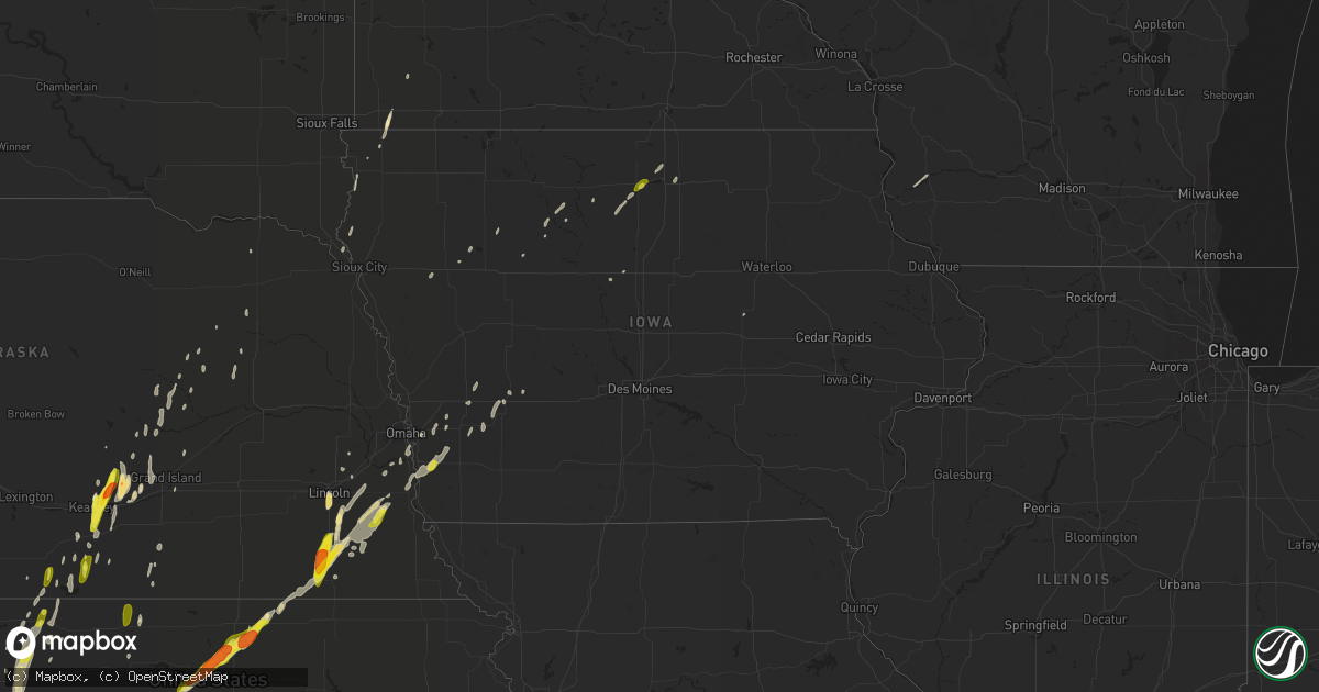
Hail Map in Iowa on April 10, 2019
Get this storm
April 10 map
$229
one time, instant access
Download today. No call, no setup
Keep the $229
Bought the map and want the full workflow? Apply the entire $229 to a subscription within 7 days. None of it is wasted.
Every map, not just this one
This buys you this map. Subscription and you get every map we run, in the markets you choose from a few cities to whole states to nationwide. Plus real-time alerts the moment a storm fires.
Contact data
Name, contact info, occupancy, even credit band for addresses in the footprint. You go from where it hit to who to call.
Become the source they trust
Unlimited branding weather history reports on demand. You already have the documented answer ready for the property owner, and you are the one who showed up with it.
Property data and RoofTrace estimates
Pull up any address you have got, its value and the exact code rules for that jurisdiction, straight from One Click Code. Then RoofTrace estimates the squares, pitch, and roof value, priced the way you price.
Storm reports in Iowa
Iowa
| Date | Description |
|---|---|
| 04/10/20196:33 AM CDT | At 1132 PM CDT, a severe thunderstorm was located near Atlantic, moving northeast at 55 mph. HAZARD...60 mph wind gusts and quarter size hail. SOURCE...Radar indicated. IMPACT...Hail damage to vehicles is expected. Expect wind damage to roofs, siding, and trees. Locations impacted include... Atlantic, Guthrie Center, Stuart, Lake Panorama, Anita, Exira, Adair, Lewis, Casey, Massena, Menlo, Cumberland, Brayton, Marne, Wiota, Lake Anita State Park, Cold Springs State Park, Atlantic Municipal Airport, Anita Municipal Airport and Springbrook State Park.This includes Interstate 80 between mile markers 50 and 93. |
| 04/10/20196:06 AM CDT | At 1105 PM CDT, a severe thunderstorm was located near Macedonia, or 28 miles southwest of Atlantic, moving northeast at 60 mph. HAZARD...60 mph wind gusts and half dollar size hail. SOURCE...Radar indicated. This storm has a history of producing a 63 mph wind gust in Sidney. IMPACT...Hail damage to vehicles is expected. Expect wind damage to roofs, siding, and trees. Locations impacted include... Red Oak, Malvern, Carson, Essex, Stanton, Emerson, Elliott, Macedonia, Silver City, Henderson, Hastings, Imogene, Coburg, Old Town Park, Farm Creek Public Wildlife Area and Pierce Recreation Area. |
| 04/10/20195:53 AM CDT | At 1052 PM CDT, a severe thunderstorm was located over Malvern, or 28 miles southeast of Omaha, moving northeast at 60 mph. An area of severe winds extended south of this thunderstorm from Malvern to Shenendoah, also moving northeast at 60 mph. HAZARD...60 mph wind gusts and quarter size hail. SOURCE...An automated weather system measured a 63 mph wind gust in Sidney with this storm. IMPACT...Hail damage to vehicles is expected. Expect wind damage to roofs, siding, and trees. Locations impacted include... Red Oak, Glenwood, Shenandoah, Malvern, Carson, Essex, Stanton, Farragut, Emerson, Elliott, Macedonia, Tabor, Silver City, Henderson, Randolph, Hastings, Imogene, Coburg, Old Town Park and Farm Creek Public Wildlife Area. |
| 04/10/20195:21 AM CDT | At 1021 PM CDT, a severe thunderstorm was located over Louisville, or 18 miles south of Omaha, moving northeast at 50 mph. HAZARD...Quarter size hail. SOURCE...Radar indicated. IMPACT...Damage to vehicles is expected. Locations impacted include... Bellevue, Papillion, La Vista, Springfield, Louisville, Cedar Creek, Offutt AFB, Camp Maha, Louisville State Recreation Area and Platte River State Park. |
| 04/10/20194:54 AM CDT | At 952 PM CDT, a severe thunderstorm was located near Sterling, or 21 miles northeast of Beatrice, moving northeast at 50 mph. HAZARD...60 mph wind gusts and half dollar size hail. SOURCE...Trained weather spotters reported nickel size hail in Sterling at 950 PM. Larger hail is likely occurring in this storm. IMPACT...Hail damage to vehicles is expected. Expect wind damage to roofs, siding, and trees. Locations impacted include... Syracuse, Sterling, Unadilla, Douglas, Dunbar, Otoe, Burr and Camp Catron. |
| 04/09/201911:30 PM CDT | A local report indicates 60 MPH wind near LEWIS |
| 04/09/201911:10 PM CDT | A local report indicates 1.00 inch wind near GARNER |
| 04/09/201910:32 PM CDT | A local report indicates 63 MPH wind near SIDNEY |
Cities Impacted by Hail Map on April 10, 2019
- Diller, NE
- Hill City, KS
- Wood River, NE
- Concordia, KS
- Simpson, KS
- Agenda, KS
- Belleville, KS
- Haddam, KS
- Beloit, KS
- Cuba, KS
- Jamestown, KS
- Scandia, KS
- Wilcox, NE
- Cushing, IA
- Portis, KS
- Garner, IA
- Glasco, KS
- Kearney, NE
- Minden, NE
- Avoca, NE
- Syracuse, NE
- Odell, NE
- Pickrell, NE
- Blue Springs, NE
- Adams, NE
- Filley, NE
- Beatrice, NE
- Cortland, NE
- De Witt, NE
- Hickman, NE
- Roca, NE
- Lincoln, NE
- Firth, NE
- Silver City, IA
- Malvern, IA
- Pacific Junction, IA
- Glenwood, IA
- Greeley, NE
- Spalding, NE
- Ayr, NE
- Glenvil, NE
- Oxford, NE
- Webster City, IA
- Gibbon, NE
- Shelton, NE
- Ravenna, NE
- Orleans, NE
- Axtell, NE
- Stamford, NE
- Magnolia, MN
- Phillips, NE
- Prairie View, KS
- Naponee, NE
- Elba, NE
- Farwell, NE
- Treynor, IA
- McClelland, IA
- Council Bluffs, IA
- Belgrade, NE
- Kanaranzi, MN
- Ellsworth, MN
- Oakley, KS
- Grinnell, KS
- Red Cloud, NE
- Lebanon, KS
- Douglas, NE
- Sterling, NE
- Palmyra, NE
- Unadilla, NE
- Bloomfield, NE
- Cairo, NE
- Grand Island, NE
- Dannebrog, NE
- Alda, NE
- Chandler, MN
- Cedar Rapids, NE
- Primrose, NE
- Wolbach, NE
- Oakland, IA
- Carson, IA
- Waverly, NE
- Holdrege, NE
- Alma, NE
- Rock Rapids, IA
- Plattsmouth, NE
- Lenora, KS
- Burr, NE
- Otoe, NE
- Blue Hill, NE
- Funk, NE
- Petersburg, NE
- Morrowville, KS
- Mahaska, KS
- Fonda, IA
- Tilden, NE
- Pocahontas, IA
- Lindsay, NE
- Long Island, KS
- Louisville, NE
- Saint Paul, NE
- Doon, IA
- Akron, IA
- Westfield, IA
- Rock Valley, IA
- Offutt Afb, NE
- Bellevue, NE
- Kanawha, IA
- Almena, KS
- Tecumseh, NE
- Albert City, IA
- Pleasanton, NE
- Riverdale, NE
- Britt, IA
- Logan, KS
- Wauzeka, WI
- Elmwood, NE
- Endicott, NE
- Walton, NE
- Eagle, NE
- Bennet, NE
- Alvo, NE
- Steele City, NE
- Brayton, IA
- Exira, IA
- Harlan, IA
- Bladen, NE
- Atlantic, IA
- Albion, NE
- Clear Lake, IA
- Smith Center, KS
- Hawarden, IA
- Alta, IA
- Griswold, IA
- Lewis, IA
- Hildreth, NE
- Galva, IA
- Ellsworth, KS
- Boscobel, WI
- Minden, IA
- Bogue, KS
- Upland, NE
- Phillipsburg, KS
- West Bend, IA
- Ottosen, IA
- Traer, IA
- Madison, NE
- Mason City, IA
- Avoca, IA
- Henderson, IA
- Murray, NE
- Union, NE
- Rolfe, IA
- Boelus, NE
- Archer, NE
- Ithaca, NE
- Elk Point, SD
- Jefferson, SD
- Stockton, KS
- Bunker Hill, KS
- Lu Verne, IA
- Glade, KS
- Pierce, NE
- Lucas, KS
- Sylvan Grove, KS
- Republican City, NE


