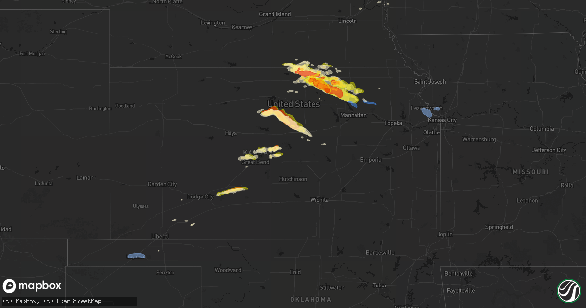
Hail Map in Kansas on April 9, 2026
Get this storm
April 9 map
$229
one time, instant access
Download today. No call, no setup
Keep the $229
Bought the map and want the full workflow? Apply the entire $229 to a subscription within 7 days. None of it is wasted.
Every map, not just this one
This buys you this map. Subscription and you get every map we run, in the markets you choose from a few cities to whole states to nationwide. Plus real-time alerts the moment a storm fires.
Contact data
Name, contact info, occupancy, even credit band for addresses in the footprint. You go from where it hit to who to call.
Become the source they trust
Unlimited branding weather history reports on demand. You already have the documented answer ready for the property owner, and you are the one who showed up with it.
Property data and RoofTrace estimates
Pull up any address you have got, its value and the exact code rules for that jurisdiction, straight from One Click Code. Then RoofTrace estimates the squares, pitch, and roof value, priced the way you price.
Storm reports in Kansas
Kansas
| Date | Description |
|---|---|
| 04/09/20266:56 PM CDT | Report from mping: quarter |
| 04/09/20266:54 PM CDT | A local report indicates 1.75 inch wind near 5 ENE Agenda |
| 04/09/20266:48 PM CDT | A local report indicates 1.75 inch wind near 4 W Hunter |
| 04/09/20266:40 PM CDT | Drifts of hail up to quarter size covering road 412. |
| 04/09/20266:33 PM CDT | Report from mping: half dollar |
| 04/09/20266:27 PM CDT | A local report indicates 1.75 inch wind near 5 ESE Belleville |
| 04/09/20266:21 PM CDT | Report from mping: golf ball |
| 04/09/20266:21 PM CDT | Reported alongside dime and nickel sized hail. |
| 04/09/20266:10 PM CDT | Report from mping: quarter |
| 04/09/20265:59 PM CDT | Trained spotter report. |
| 04/09/20265:47 PM CDT | Relayed by wichita media outlet. |
| 04/09/20262:47 AM CDT | Several large tree branches down across burlington. One large limb knocked down power lines. Time estimated from radar. |
| 04/08/202610:40 PM CDT | Part of roof removed. Confirmed by em through photos. Time estimated from radar. |
| 04/08/202610:38 PM CDT | A local report indicates 64 MPH wind near 3 W Fairmount |
| 04/08/20268:02 PM CDT | Delayed report. Barn heavily damaged no estimated wind speed given. |
| 04/08/20267:39 PM CDT | A local report indicates 2.00 inch wind near 1 N Greenleaf |
| 04/08/20267:25 PM CDT | A local report indicates 1.00 inch wind near 4 E Agenda |
| 04/08/20267:24 PM CDT | A local report indicates 1.75 inch wind near 6 ENE Ash Grove |
| 04/08/20267:12 PM CDT | A local report indicates 1.75 inch wind near 4 N Lorraine |
| 04/08/20267:10 PM CDT | A local report indicates 1.00 inch wind near 3 N Lorraine |
| 04/08/20267:00 PM CDT | A local report indicates 1.00 inch wind near 6 E Agenda |
All States Impacted by Hail Map on April 9, 2026
Cities Impacted by Hail Map on April 9, 2026
- Clifton, KS
- Palmer, KS
- Linn, KS
- Greenleaf, KS
- Somes Bar, CA
- Forks Of Salmon, CA
- Orleans, CA
- Camas Valley, OR
- Pecos, TX
- Myrtle Creek, OR
- Scandia, KS
- Courtland, KS
- Mankato, KS
- Webber, KS
- Belleville, KS
- Republic, KS
- Byron, NE
- Hardy, NE
- Omaha, NE
- Hoisington, KS
- Agenda, KS
- Cuba, KS
- Deshler, NE
- Haddam, KS
- Fowler, KS
- Hebron, NE
- Ruskin, NE
- Waldo, KS
- Narka, KS
- Claflin, KS
- Ashland, OR
- Nelson, NE
- Osborne, KS
- Crescent, IA
- Underwood, IA
- Superior, NE
- Luray, KS
- Lucas, KS
- Munden, KS
- Rush Center, KS
- Honey Creek, IA
- Washington, KS
- Morrowville, KS
- Sylvan Grove, KS
- Hunter, KS
- Amarillo, TX
- Holyrood, KS
- Otis, KS
- Albert, KS
- Pawnee Rock, KS
- Clyde, KS
- Chester, NE
- Olmitz, KS
- Great Bend, KS
- Lorraine, KS
- Beloit, KS
- Tipton, KS
- Bushton, KS
- Papillion, NE
- Greenwood, NE
- Ashland, NE
- Barnes, KS
- Barnard, KS
- Pacific Junction, IA
- Hubbell, NE
- Bellevue, NE
- Ellsworth, KS
- Hanover, KS
- Firebaugh, CA
- Montgomery Creek, CA
- Glenwood, IA
- Lincoln, KS
- Dos Palos, CA
- Green, KS
- Randall, KS
- Jewell, KS
- Beverly, KS
- Minneapolis, KS
- Tescott, KS
- Chowchilla, CA
- Waterville, KS
- Jamestown, KS
- Chase, KS
- Ellinwood, KS
- Blue Rapids, KS
- Randolph, KS
- Skellytown, TX
- Marysville, KS
- Frankfort, KS
- Olsburg, KS
- Hooker, OK
- Turpin, OK
- Guymon, OK
- Salina, KS
- Geneseo, KS
- Lyons, KS
- Westmoreland, KS
- Brookville, KS
- New Cambria, KS
- Fairbury, NE
- Vermillion, KS
- Onaga, KS
- Endicott, NE
- Mahaska, KS
- Corning, KS
- Goff, KS
- Modesto, CA
- Patterson, CA
- Ceres, CA
- Keyes, CA
- Hughson, CA
- Empire, CA
- Morganville, KS
- Reynolds, NE
- Montezuma, KS
- Steele City, NE
- Spearville, KS
- Escalon, CA
- Offerle, KS
- Kinsley, KS
- Hollenberg, KS
- Merced, CA
- Lewis, KS
- Belpre, KS
- Macksville, KS
- Leavenworth, KS
- Basehor, KS
- Lansing, KS
- Kansas City, KS
- Kansas City, MO
- Assaria, KS
- Hope, KS
- Plains, KS
- Meade, KS


