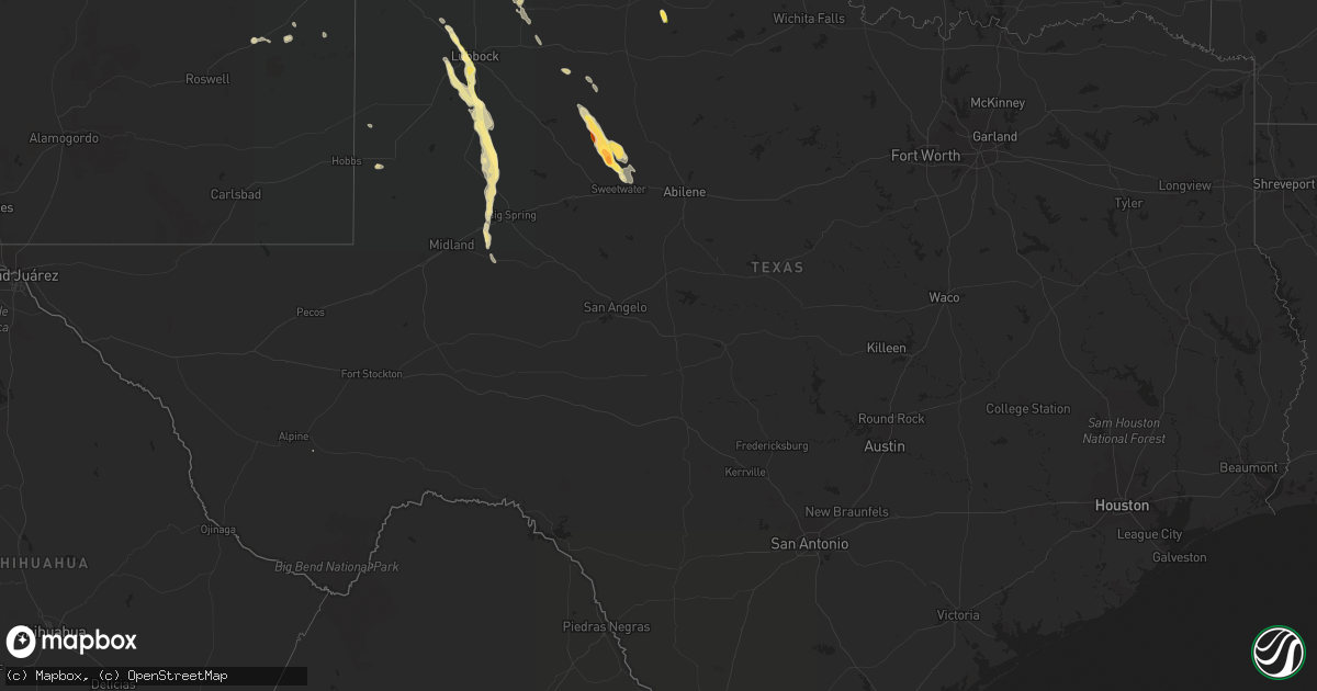
Hail Map in Texas on April 9, 2023
Get this storm
April 9 map
$229
one time, instant access
Download today. No call, no setup
Keep the $229
Bought the map and want the full workflow? Apply the entire $229 to a subscription within 7 days. None of it is wasted.
Every map, not just this one
This buys you this map. Subscription and you get every map we run, in the markets you choose from a few cities to whole states to nationwide. Plus real-time alerts the moment a storm fires.
Contact data
Name, contact info, occupancy, even credit band for addresses in the footprint. You go from where it hit to who to call.
Become the source they trust
Unlimited branding weather history reports on demand. You already have the documented answer ready for the property owner, and you are the one who showed up with it.
Property data and RoofTrace estimates
Pull up any address you have got, its value and the exact code rules for that jurisdiction, straight from One Click Code. Then RoofTrace estimates the squares, pitch, and roof value, priced the way you price.
Storm reports in Texas
Texas
| Date | Description |
|---|---|
| 04/09/20236:54 PM CDT | West texas mesonet. |
| 04/09/20236:45 PM CDT | A local report indicates 1.00 inch wind near 1 E SHALLOWATER |
| 04/09/20236:15 PM CDT | Copious accumulations of hail. |
| 04/09/20236:10 PM CDT | West texas mesonet. |
| 04/09/20235:48 PM CDT | Corrects previous hail report from 4 w roby. The sheriffs office reported that baseball size hail along highway 180. |
| 04/09/20235:48 PM CDT | The sheriffs office reported that baseball size hail occurred at the intersection of highway 180 and fm 2832. |
| 04/09/20235:40 PM CDT | Mesonet station 113 5w rotan rotan/fisher county. |
| 04/09/20235:26 PM CDT | A spotter reported quarter size hail piled up along county road 327. |
| 04/08/20238:45 PM CDT | A local report indicates 1.00 inch wind near TAHOKA |
| 04/08/20238:24 PM CDT | West texas mesonet. First severe gust to 58 mph at 823 pm. |
| 04/08/20237:53 PM CDT | West texas mesonet |
| 04/08/20237:53 PM CDT | West texas mesonet. |
| 04/08/20237:19 PM CDT | Mostly nickel size. Hail began at 719 pm and ended at 718 pm. |
| 04/08/20237:19 PM CDT | Nws office measured mostly dime to nickel size. Hail began at 709 pm and ended at 718 pm. |
| 04/08/20237:15 PM CDT | 56th street and memphis ave |
| 04/08/20237:15 PM CDT | 56th st and utica ave. |
| 04/08/20237:15 PM CDT | 56th street and memphis ave. |
| 04/08/20237:07 PM CDT | Several reports of hail in west lubbock ranging in size from nickel to quarter size. |
| 04/08/20237:00 PM CDT | A few to quarter size. |
Cities Impacted by Hail Map on April 9, 2023
- Meade, KS
- Mangum, OK
- Quanah, TX
- Jayton, TX
- Girard, TX
- Olustee, OK
- Eldorado, OK
- Marathon, TX
- Spur, TX
- Childress, TX
- Turkey, TX
- Quitaque, TX
- Lockney, TX
- Flomot, TX
- Matador, TX
- Snyder, TX
- Rotan, TX
- Roby, TX
- Crowell, TX
- Sweetwater, TX
- Shallowater, TX
- Lubbock, TX
- Ropesville, TX
- Wolfforth, TX
- Tahoka, TX
- Wilson, TX
- Odonnell, TX
- Lamesa, TX
- Gail, TX
- Floydada, TX
- Hastings, NE
- Anton, TX
- Dimmitt, TX
- Denver City, TX
- Silverton, TX
- Kress, TX
- Odell, TX
- Vernon, TX
- Elmer, OK
- Harvard, NE
- Crosbyton, TX
- Trent, TX
- Sylvester, TX
- Forgan, OK
- Seminole, TX
- Trumbull, NE
- Juniata, NE
- Meadow, TX
- Garden City, TX
- Stanton, TX
- Knott, TX
- Ackerly, TX
- Lenorah, TX
- Pep, NM
- Roswell, NM
- Elida, NM
- Convoy, OH
- Van Wert, OH


