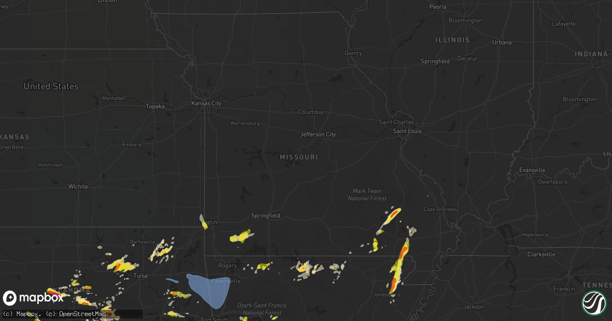
Hail Map in Missouri on April 9, 2021
Get this storm
April 9 map
$229
one time, instant access
Download today. No call, no setup
Keep the $229
Bought the map and want the full workflow? Apply the entire $229 to a subscription within 7 days. None of it is wasted.
Every map, not just this one
This buys you this map. Subscription and you get every map we run, in the markets you choose from a few cities to whole states to nationwide. Plus real-time alerts the moment a storm fires.
Contact data
Name, contact info, occupancy, even credit band for addresses in the footprint. You go from where it hit to who to call.
Become the source they trust
Unlimited branding weather history reports on demand. You already have the documented answer ready for the property owner, and you are the one who showed up with it.
Property data and RoofTrace estimates
Pull up any address you have got, its value and the exact code rules for that jurisdiction, straight from One Click Code. Then RoofTrace estimates the squares, pitch, and roof value, priced the way you price.
Storm reports in Missouri
Missouri
| Date | Description |
|---|---|
| 04/09/20216:20 PM CDT | Large rotted tree landed on a house... Causing extensive damage. Occurred at same time and location as carport blown over fence. |
| 04/09/20216:10 PM CDT | Old trailer blown across county road 640 near stoddard county line. Tin roofing blown around. |
| 04/09/20215:35 PM CDT | A local report indicates 1.00 inch wind near FISK |
| 04/09/20215:30 PM CDT | A local report indicates 1.00 inch wind near PUXICO |
| 04/09/20215:30 PM CDT | Power lines down... Blocking road. |
| 04/09/20215:13 PM CDT | In community of broseley. |
| 04/09/20215:07 PM CDT | A local report indicates 1.00 inch wind near QULIN |
| 04/09/20214:57 PM CDT | A local report indicates 1.75 inch wind near PATTERSON |
| 04/09/20214:47 PM CDT | A local report indicates 1.00 inch wind near 3 W ELLSINORE |
| 04/09/20214:37 PM CDT | Covering the ground. |
| 04/09/20214:34 PM CDT | A local report indicates 1.50 inch wind near DONIPHAN |
| 04/09/20214:24 PM CDT | Electric company reported hundreds of outages due to high winds across the howell-oregon county electric area. Several public weather stations reported measured wind gu |
| 04/09/20214:19 PM CDT | Quarter size hail near lone star school. |
| 04/09/20214:04 PM CDT | Social media report of quarter size hail in thayer. |
| 04/09/20213:59 PM CDT | Public report of quarter size hail. |
| 04/09/20213:54 PM CDT | Corrects previous hail report from purdy. |
| 04/09/20213:45 PM CDT | A local report indicates 1.00 inch wind near 1 N MADRY |
| 04/09/20213:28 PM CDT | Slightly higher than quarter size reported near butterfield via social media. |
| 04/09/20215:18 AM CDT | At 1017 PM CDT, severe thunderstorms were located along a line extending from near Grandview to Marble to near Pettigrew, moving east at 50 mph. HAZARD...60 mph wind gusts. SOURCE...Radar indicated. IMPACT...Expect damage to roofs, siding, and trees. Locations impacted include... Harrison... Jasper... Diamond City... Bergman... Western Grove... Lead Hill... Valley Springs... Omaha... Dugger... Olvey... Roberson Hollow... Carver... Erbie... Moore... Upper Buffalo Wilderness Area... Winington... Lost Valley State Park... Pruitt... Myrtle... Self... |
| 04/09/202112:04 AM CDT | At 503 PM CDT, a severe thunderstorm was located over Sam A. Baker State Park, moving northeast at 30 mph. HAZARD...Golf ball size hail and 60 mph wind gusts. SOURCE...Radar indicated. IMPACT...People and animals outdoors will be injured. Expect hail damage to roofs, siding, windows, and vehicles. Expect wind damage to roofs, siding, and trees. Locations impacted include... Marquand, Buckhorn and Saco. |
| 04/09/202112:03 AM CDT | At 503 PM CDT, severe thunderstorms were located along a line extending from near Garwood to near Doniphan, moving northeast at 25 mph. HAZARD...60 mph wind gusts and quarter size hail. SOURCE...Radar indicated. IMPACT...Hail damage to vehicles is expected. Expect wind damage to roofs, siding, and trees. Locations impacted include... Piedmont, Ellsinore, Williamsville, Budapest, Hunter, Brush Arbor, Grandin and Mill Spring. |
| 04/08/202111:57 PM CDT | At 456 PM CDT, a severe thunderstorm was located near Sam A. Baker State Park, moving northeast at 30 mph. HAZARD...Golf ball size hail and 60 mph wind gusts. SOURCE...Radar indicated. IMPACT...People and animals outdoors will be injured. Expect hail damage to roofs, siding, windows, and vehicles. Expect wind damage to roofs, siding, and trees. Locations impacted include... Sam A. Baker State Park, Greenville, Lodi and Cascade. |
| 04/08/202111:49 PM CDT | At 448 PM CDT, severe thunderstorms were located along a line extending from near Milltown to near Qulin to Piggott to Senath, moving north at 60 mph. This storm has had a history of producing large hail in northeast Arkansas. HAZARD...Ping pong ball size hail and 60 mph wind gusts. SOURCE...Radar indicated. IMPACT...People and animals outdoors will be injured. Expect hail damage to roofs, siding, windows, and vehicles. Expect wind damage to roofs, siding, and trees. Locations impacted include... Poplar Bluff, Dexter, Bernie, Puxico, Qulin, Fisk, Dudley, Harviell, Hendrickson and Rombauer. |
| 04/08/202111:30 PM CDT | At 430 PM CDT, a severe thunderstorm was located 9 miles southwest of Handy, or 20 miles west of Doniphan, moving northeast at 50 mph. HAZARD...60 mph wind gusts and half dollar size hail. SOURCE...Radar indicated. IMPACT...Hail damage to vehicles is expected. Expect wind damage to roofs, siding, and trees. Locations impacted include... Handy. |
| 04/08/202111:27 PM CDT | At 426 PM CDT, severe thunderstorms were located along a line extending from 7 miles south of Piedmont to near Hunter, moving east at 20 mph. HAZARD...60 mph wind gusts and quarter size hail. SOURCE...Radar indicated. IMPACT...Hail damage to vehicles is expected. Expect wind damage to roofs, siding, and trees. Locations impacted include... Greenville, Ellsinore, Williamsville, Hunter, Brush Arbor, Grandin and Mill Spring. |
| 04/08/202111:24 PM CDT | At 424 PM CDT, severe thunderstorms were located along a line extending from 8 miles east of West Plains to near Alton to 12 miles west of Gatewood, moving north at 30 mph. HAZARD...60 mph wind gusts and quarter size hail. SOURCE...Radar indicated. IMPACT...Hail damage to vehicles is expected. Expect wind damage to roofs, siding, and trees. Locations impacted include... Mountain View... Winona... Alton... Birch Tree... Eminence... Summersville... Brandsville... Montier... Thomasville... Peace Valley... Teresita... Wilderness... Couch... Rover... Alley Spring... West Eminence... Greer... |
| 04/08/202111:22 PM CDT | At 421 PM CDT, a severe thunderstorm was located over Doniphan, moving east at 15 mph. HAZARD...Quarter size hail. SOURCE...Trained weather spotters. IMPACT...Damage to vehicles is expected. Locations impacted include... Doniphan, Budapest, Oxly and Fairdealing. |
| 04/08/202111:19 PM CDT | At 419 PM CDT, a severe thunderstorm was located near Lafe, or 10 miles west of Marmaduke, moving northeast at 30 mph. HAZARD...60 mph wind gusts and quarter size hail. SOURCE...Radar indicated. IMPACT...Hail damage to vehicles is expected. Expect wind damage to roofs, siding, and trees. Locations impacted include... Piggott, Corning, Chalk Bluff Natural Area, Oak Grove Heights, Lafe, Knobel, St. Francis, Pollard, McDougal, Peach Orchard, Saint Francis, Beech Grove, Crockett, Stonewall, Tipperary, Hickoria, Gainesville, Knob and Chalk Bluff Battlefield Park. |
| 04/08/202111:07 PM CDT | At 407 PM CDT, a severe thunderstorm was located near Brookland, moving northeast at 30 mph. HAZARD...Ping pong ball size hail and 60 mph wind gusts. SOURCE...Radar indicated. IMPACT...People and animals outdoors will be injured. Expect hail damage to roofs, siding, windows, and vehicles. Expect wind damage to roofs, siding, and trees. Locations impacted include... Paragould, Lake City, Rector, Senath, Brookland, Marmaduke, Oak Grove Heights, Cardwell, Arbyrd, Lafe, Heubner, Macey, Schug, Fritz, Bard, Lester, Mounds, Halliday, Leonard and Bethel. |
| 04/08/202110:57 PM CDT | At 356 PM CDT, a severe thunderstorm was located over Bay, moving northeast at 25 mph. HAZARD...60 mph wind gusts and quarter size hail. SOURCE...Radar indicated. IMPACT...Hail damage to vehicles is expected. Expect wind damage to roofs, siding, and trees. Locations impacted include... Jonesboro, Paragould, Trumann, Manila, Lake City, Leachville, Bay, Brookland, Monette, Caraway, Cardwell, Arbyrd, Black Oak, Jolliff Store, Apt, Delfore, Vail, Carmi, Gum Point and Whisp. |
| 04/08/202110:54 PM CDT | At 354 PM CDT, a severe thunderstorm was located near Purdy, or 8 miles northwest of Cassville, moving north at 20 mph. HAZARD...60 mph wind gusts and half dollar size hail. SOURCE...Radar indicated. IMPACT...Hail damage to vehicles is expected. Expect wind damage to roofs, siding, and trees. Locations impacted include... Monett... Pierce City... Purdy... Wheaton... Verona... Butterfield... Pioneer... |
| 04/08/202110:41 PM CDT | At 340 PM CDT, severe thunderstorms were located along a line extending from Gamaliel Landing to near Salem in Fulton County to Ballard, moving north at 35 mph. HAZARD...60 mph wind gusts and half dollar size hail. SOURCE...Radar indicated. IMPACT...Hail damage to vehicles is expected. Expect wind damage to roofs, siding, and trees. Locations impacted include... West Plains... Norfork Lake... Grand Gulf State Park... Thayer... Alton... Gainesville... Bakersfield... South Fork... Koshkonong... Brandsville... Lanton... Myrtle... Wilderness... Tecumseh... Couch... Pottersville... Caulfield... Udall... Hardenville... Rover... |
| 04/08/202110:29 PM CDT | At 329 PM CDT, a severe thunderstorm was located near Cassville, moving northeast at 20 mph. HAZARD...60 mph wind gusts and half dollar size hail. SOURCE...Radar indicated. IMPACT...Hail damage to vehicles is expected. Expect wind damage to roofs, siding, and trees. Locations impacted include... Aurora... Cassville... Marionville... Crane... Purdy... Butterfield... Galena... Mccord Bend... Wheelerville... Jenkins... Mcdowell... Pleasant Ridge... Madry... Elsey... |
| 04/08/202110:14 PM CDT | At 313 PM CDT, severe thunderstorms were located along a line extending from near Bull Shoals State Park to near Rodney, moving northeast at 65 mph. HAZARD...60 mph wind gusts and half dollar size hail. SOURCE...Radar indicated. IMPACT...Hail damage to vehicles is expected. Expect wind damage to roofs, siding, and trees. Locations impacted include... Mountain Home... Bull Shoals... Gassville... Calico Rock... Flippin... Lakeview in Baxter County... Norfork... Salesville... Viola... Pineville... Briarcliff... Arkawana... Bexar... Norfork Dam... Diamond Bay... Flint Springs... Ott... Ozark Regional Airport... Gamaliel Landing... Fawn Park... |
| 04/08/20219:54 PM CDT | At 253 PM CDT, severe thunderstorms were located along a line extending from 6 miles southeast of Gateway to near Urbanette to 6 miles north of Carrollton to near Harrison, moving north at 30 mph. HAZARD...Half dollar size hail. SOURCE...Radar indicated. IMPACT...Damage to vehicles is expected. Locations impacted include... Branson... Lake Taneycomo... Table Rock Lake... Bull Shoals Lake... Roaring River State Park... Table Rock State Park... Hollister... Cassville... Silver Dollar City... Kimberling City... Forsyth... Merriam Woods... Shell Knob... Kissee Mills... Purdy... Reeds Spring... Seligman... Rockaway Beach... Exeter... Bull Creek... |
All States Impacted by Hail Map on April 9, 2021
Cities Impacted by Hail Map on April 9, 2021
- Tamaroa, IL
- Pinckneyville, IL
- Yellville, AR
- Lakeview, AR
- Gassville, AR
- Norfork, AR
- Bull Shoals, AR
- Mountain Home, AR
- Cotter, AR
- Flippin, AR
- Grandin, MO
- Ellsinore, MO
- Pontotoc, MS
- Puxico, MO
- Dudley, MO
- Bloomfield, MO
- Lawsonville, NC
- Danbury, NC
- Westfield, NC
- Lowgap, NC
- Pilot Mountain, NC
- Mount Airy, NC
- Pottsboro, TX
- Kingston, OK
- Overbrook, OK
- Marietta, OK
- Ardmore, OK
- Sulphur, LA
- Lake Charles, LA
- Blue Mountain, MS
- New Albany, MS
- Henderson, TX
- Mount Enterprise, TX
- Laneville, TX
- Moyock, NC
- South Mills, NC
- Harrison, AR
- Omaha, AR
- State Line, MS
- Pocahontas, TN
- De Kalb, TX
- Simms, TX
- Mer Rouge, LA
- McGee, MO
- Wappapello, MO
- Rose Hill, MS
- Calico Rock, AR
- Williston, TN
- Moscow, TN
- Rush Springs, OK
- Ninnekah, OK
- Marbury, AL
- Deatsville, AL
- Chelsea, OK
- Coffeeville, AL
- Frankville, AL
- Jackson, AL
- Mentone, AL
- Menlo, GA
- New Edinburg, AR
- Fordyce, AR
- Thornton, AR
- Avery, TX
- Cookville, TX
- Talco, TX
- Mount Pleasant, TX
- Omaha, TX
- Mount Vernon, TX
- Livingston, AL
- Byars, OK
- Fitzhugh, OK
- Fittstown, OK
- Stonewall, OK
- Wanette, OK
- Sulphur, OK
- Tishomingo, OK
- Ada, OK
- Asher, OK
- Roff, OK
- Macomb, OK
- Mill Creek, OK
- Stratford, OK
- Dubach, LA
- Chickasha, OK
- Forest, MS
- Raleigh, MS
- Windsor, NC
- Colerain, NC
- Somerville, TN
- Prattville, AL
- Dry Fork, VA
- Cassville, MO
- Fairfax, OK
- Pawnee, OK
- Skiatook, OK
- Cleveland, OK
- Prue, OK
- Osage, OK
- Hominy, OK
- Maramec, OK
- Sperry, OK
- Adair, OK
- Muskogee, OK
- Oakland, AR
- Henderson, NC
- Meeker, OK
- Sparks, OK
- Earlsboro, OK
- Okemah, OK
- Seminole, OK
- Depew, OK
- Chandler, OK
- Stroud, OK
- Shawnee, OK
- Prague, OK
- Paden, OK
- Boley, OK
- Coalgate, OK
- Brandon, MS
- Grapeland, TX
- Woodworth, LA
- Hackberry, LA
- Cushing, TX
- Venus, TX
- Midlothian, TX
- Wagarville, AL
- Leroy, AL
- Thomasville, AL
- Sweet Water, AL
- Campbell, AL
- Pine Hill, AL
- Dixons Mills, AL
- Paulding, MS
- Columbus, MS
- Millport, AL
- Ethelsville, AL
- Newton, MS
- Hickory, MS
- Decatur, MS
- Chesapeake, VA
- Sulphur Bluff, TX
- Pittsburg, TX
- Mendenhall, MS
- Butler, AL
- Brownsville, TN
- Denmark, TN
- West Monroe, LA
- Eros, LA
- Chatham, LA
- Columbia, LA
- Grayson, LA
- Traskwood, AR
- Chidester, AR
- Robertsdale, AL
- Alto, TX
- Trinidad, TX
- Virgilina, VA
- Big Cabin, OK
- Italy, TX
- Forreston, TX
- Bristow, OK
- Marion, LA
- Trout, LA
- Altamont, KS
- Edna, KS
- Idabel, OK
- Foreman, AR
- Haworth, OK
- Garvin, OK
- Chatom, AL
- Millry, AL
- Deport, TX
- Hendrix, OK
- Forney, TX
- Coushatta, LA
- Seminole, AL
- Wetumpka, AL
- Titus, AL
- El Dorado, AR
- Greenville, MO
- Shalimar, FL
- Valparaiso, FL
- Mary Esther, FL
- Eglin Afb, FL
- Fort Walton Beach, FL
- Niceville, FL
- Hurlburt Field, FL
- Naples, TX
- Sulphur Springs, TX
- Meridian, MS
- Palestine, TX
- Elkhart, TX
- Crockett, TX
- Minco, OK
- Amber, OK
- Anadarko, OK
- Alex, OK
- Pocasset, OK
- Blanchard, OK
- Smithfield, VA
- Porum, OK
- Warner, OK
- Checotah, OK
- Webbers Falls, OK
- Vardaman, MS
- Calhoun City, MS
- Longview, TX
- Jacksonville, TX
- Troup, TX
- Houston, MS
- Arcadia, LA
- Kosciusko, MS
- Monroe, LA
- Patterson, MO
- Piedmont, MO
- Silva, MO
- Lodi, MO
- Mill Spring, MO
- Pachuta, MS
- Maysville, WV
- Wellston, OK
- Kingfisher, OK
- Wheaton, MO
- Exeter, MO
- Monett, MO
- Purdy, MO
- Verona, MO
- Butterfield, MO
- Fairview, MO
- Aurora, MO
- Crane, MO
- Galena, MO
- Taylorsville, MS
- Bay Springs, MS
- Claremore, OK
- Vinita, OK
- Mulhall, OK
- Warren, AR
- Grand Junction, TN
- Garrison, TX
- McDavid, FL
- Bastrop, LA
- Collinston, LA
- Huttig, AR
- Crossett, AR
- Michie, TN
- Goldonna, LA
- Morton, MS
- Luther, OK
- Arcadia, OK
- Rock Cave, WV
- Kanawha Head, WV
- Lillian, AL
- Denison, TX
- Flowood, MS
- Nacogdoches, TX
- Waynesboro, MS
- Qulin, MO
- Homer, LA
- Dallas, TX
- Seagoville, TX
- Sallis, MS
- Durant, MS
- West, MS
- Ruston, LA
- Waxahachie, TX
- Elberta, AL
- Gulf Shores, AL
- Orange Beach, AL
- Ash Flat, AR
- Horseshoe Bend, AR
- Franklin, AR
- Wiseman, AR
- Edenton, NC
- Merry Hill, NC
- Chunky, MS
- Reklaw, TX
- Corning, AR
- Paragould, AR
- Marmaduke, AR
- Piggott, AR
- Rector, AR
- Brookland, AR
- Lafe, AR
- Gulf Breeze, FL
- Poplar Bluff, MO
- Broseley, MO
- Maud, OK
- Tecumseh, OK
- Chatham, VA
- Danville, VA
- Pioneer, LA
- Manson, NC
- Talala, OK
- Oologah, OK
- Graceville, FL
- Slocomb, AL
- Cottonwood, AL
- Blue Springs, MS
- Paris, AR
- Altus, AR
- Ozark, AR
- South Boston, VA
- Ringgold, VA
- Halifax, VA
- Martinsville, VA
- Keeling, VA
- Callands, VA
- Alton, VA
- Sutherlin, VA
- Axton, VA
- Blairs, VA
- Guthrie, OK
- Crescent, OK
- Norman, OK
- Philadelphia, MS
- Indian Valley, VA
- Marston, NC
- Pinebluff, NC
- Aberdeen, NC
- Hoffman, NC
- Laurinburg, NC
- Laurel Hill, NC
- Tupelo, MS
- Plantersville, MS
- Caddo, OK
- Mangham, LA
- Rayville, LA
- Kelly, LA
- Fisher, WV
- Cabins, WV
- Petersburg, WV
- Moorefield, WV
- Jackson, NC
- Rich Square, NC
- Ralph, AL
- Fosters, AL
- Buhl, AL
- Gasburg, VA
- Valentines, VA
- Downsville, LA
- Farmerville, LA
- Ethel, MS
- Jena, LA
- Louin, MS
- Marble Hill, MO
- Advance, MO
- Kerens, TX
- Red Oak, TX
- Desoto, TX
- Lancaster, TX
- Oxford, NC
- Myrtle, MS
- Hickory Flat, MS
- Boligee, AL
- Doniphan, MO
- Vian, OK
- Mooreville, MS
- Knobel, AR
- Delaplaine, AR
- Catherine, AL
- Grove Hill, AL
- Silas, AL
- Saint Stephens, AL
- Echola, AL
- Gordo, AL
- Elrod, AL
- Holdenville, OK
- Needham, AL
- Monroeville, AL
- Okolona, MS
- Willis, VA
- Rocky Mount, VA
- Callaway, VA
- Riner, VA
- Ferrum, VA
- Floyd, VA
- Alpena, AR
- Green Forest, AR
- Fruitdale, AL
- Timpson, TX
- Tenaha, TX
- Center, TX
- Laurel, MS
- Des Arc, MO
- Annapolis, MO
- Star City, AR
- Monticello, AR
- Rison, AR
- Wilmar, AR
- Pelahatchie, MS
- Warm Springs, VA
- Marlinton, WV
- Bethel Springs, TN
- Finger, TN
- Henderson, TN
- Dumas, MS
- Belden, MS
- Saltillo, MS
- Thaxton, MS
- Guntown, MS
- Baldwyn, MS
- Ecru, MS
- Ripley, MS
- Rowlett, TX
- Rockwall, TX
- Garland, TX
- Hickory Valley, TN
- Kennard, TX
- Olla, LA
- Harrisonburg, LA
- Gardendale, AL
- Binger, OK
- Bradley, OK
- Grandview, TX
- Milford, TX
- Cedarbluff, MS
- Woodland, MS
- West Point, MS
- Northport, AL
- Oak Ridge, LA
- Sterlington, LA
- Simsboro, LA
- Choudrant, LA
- Calhoun, LA
- Ponca City, OK
- Mammoth Spring, AR
- Dothan, AL
- Pensacola, FL
- Mesquite, TX
- Lamar, MS
- Madill, OK
- Mannsville, OK
- Lake Creek, TX
- Blossom, TX
- Detroit, TX
- Cooper, TX
- Bogata, TX
- Paris, TX
- Pattonville, TX
- Ackerman, MS
- Lewisville, AR
- Buckatunna, MS
- Hinton, OK
- Bremen, AL
- Empire, AL
- Hayden, AL
- Warrior, AL
- Dora, AL
- Sumiton, AL
- Jasper, AL
- Maypearl, TX
- Carthage, MS
- Tallulah, LA
- Delhi, LA
- Picayune, MS
- Kiln, MS
- Nauvoo, AL
- Carbon Hill, AL
- Covington, TN
- Athens, LA
- Soso, MS
- Stringer, MS
- Covington, LA
- Mandeville, LA
- Abita Springs, LA
- Louisville, MS
- Murphysboro, IL
- Ava, IL
- Scammon, KS
- Pittsburg, KS
- Weir, KS
- Ashland, LA
- Saline, LA
- Mulkeytown, IL
- Du Quoin, IL
- Gilbertown, AL
- Safford, AL
- Bluejacket, OK
- Glencoe, AR
- Salem, AR
- Trussville, AL
- Pinson, AL
- Eclectic, AL
- Malvern, AR
- Donaldson, AR
- Mansfield, LA
- Peterman, AL
- Quitman, MS
- Athens, TX
- Walnut, MS
- Minter, AL
- Brodnax, VA
- La Crosse, VA
- Ebony, VA
- Raeford, NC
- Carrollton, AL
- Bracey, VA
- Mcloud, OK
- Sparta, IL
- Columbia, AL
- Pansey, AL
- Blakely, GA
- Ashford, AL
- Coyle, OK
- Selmer, TN
- Adamsville, TN
- Coker, AL
- Tuscaloosa, AL
- Garysburg, NC
- Macon, NC
- Bolivar, TN
- Noxapater, MS
- Hector, AR
- Dover, AR
- Wewoka, OK
- Calera, OK
- Maben, MS
- Herrin, IL
- Johnston City, IL
- Carterville, IL
- Perry, OK
- Newalla, OK
- Eupora, MS
- Strong, AR
- Tallassee, AL
- Elizabeth, AR
- Montalba, TX
- Malakoff, TX
- Tennessee Colony, TX
- Berryville, AR
- Sibley, LA
- Wagram, NC
- Red Springs, NC
- Canton, MS
- Daingerfield, TX
- Moundville, AL
- Akron, AL
- Mabank, TX
- Henning, TN
- Ripley, TN
- Houlka, MS
- Ashdown, AR
- Hamburg, AR
- Parrish, AL
- Roxboro, NC
- Mathiston, MS
- McCool, MS
- Bunch, OK
- Milburn, OK
- Konawa, OK
- Tupelo, OK
- Jonesville, LA
- Monterey, LA
- Marion, AL
- Greensboro, AL
- Perkins, OK
- Lexington, OK
- Weir, MS
- Theodosia, MO
- Sand Springs, OK
- Ferris, TX
- Wilmer, TX
- Hutchins, TX
- Trumann, AR
- Sikes, LA
- Bell City, LA
- Iowa, LA
- Jonesboro, LA
- Bernice, LA
- Dodson, LA
- Grambling, LA
- Eutaw, AL
- Leesburg, TX
- Rosston, AR
- Collinsville, MS
- Little Rock, MS
- Enterprise, MS
- Odenville, AL
- Graysville, AL
- Quinton, AL
- Kimberly, AL
- Morris, AL
- Cordova, AL
- Murchison, TX
- Suffolk, VA
- Leeds, AL
- Stamps, AR
- Henrico, NC
- Gaston, NC
- Wills Point, TX
- Steens, MS
- Winnfield, LA
- Rusk, TX
- Vossburg, MS
- Shubuta, MS
- Cashion, OK
- Okarche, OK
- Virginia Beach, VA
- Casscoe, AR
- Oak Ridge, MO
- Daisy, MO
- Bennington, OK
- Bokchito, OK
- Terlton, OK
- Sage, AR
- Melbourne, AR
- Goodman, MS
- Vaiden, MS
- Alton, MO
- Richton, MS
- Oakland, TN
- Woodland, NC
- Weldon, NC
- Gibsland, LA
- Hornsby, TN
- Kaufman, TX
- Porter, OK
- Double Springs, AL
- Magnolia, AR
- Heidelberg, MS
- Orrville, AL
- Russellville, AR
- Kenbridge, VA
- Brent, AL
- Lahmansville, WV
- Blooming Grove, TX
- Barry, TX
- Frost, TX
- Itasca, TX
- Alvarado, TX
- Purdon, TX
- Christopher, IL
- Benton, IL
- Friedheim, MO
- Buffalo Junction, VA
- Nelson, VA
- Bullock, NC
- Clarksville, VA
- Pineville, LA
- Effie, LA
- Marksville, LA
- Deville, LA
- Center Point, LA
- Dike, TX
- Valley Springs, AR
- Stanton, TN
- Mason, TN
- Fairfield, TX
- Oakwood, TX
- Wilsonville, AL
- Sylacauga, AL
- Childersburg, AL
- Winona, MS
- Corinth, MS
- Guys, TN
- Glen, MS
- Ramer, TN
- Rienzi, MS
- Newellton, LA
- Winnsboro, LA
- Baskin, LA
- Sondheimer, LA
- New Site, MS
- Marietta, MS
- Mantachie, MS
- Barnsdall, OK
- Holly Springs, NC
- Sanford, NC
- Willow Spring, NC
- Angier, NC
- Fuquay Varina, NC
- Benson, NC
- Thayer, MO
- Roanoke Rapids, NC
- Middleton, TN
- Equality, AL
- Melvin, AL
- Bells, TN
- Lead Hill, AR
- Kennedy, AL
- Fayette, AL
- Wynona, OK
- Fort Gibson, OK
- Vergennes, IL
- Arley, AL
- Stewart, MS
- Kilmichael, MS
- Plymouth, NC
- Delaware, OK
- Nowata, OK
- Spearsville, LA
- Kelford, NC
- Vinton, LA
- Hampton, AR
- Camden, AR
- Mannford, OK
- Cardwell, MO
- Semora, NC
- Cowarts, AL
- Bonifay, FL
- Campbellton, FL
- Lecompte, LA
- Alexandria, LA
- Bartlett, KS
- Carriere, MS
- Perkinston, MS
- Saucier, MS
- Pass Christian, MS
- Bay Saint Louis, MS
- Huntsville, AR
- Lena, MS
- Silverhill, AL
- Birmingham, AL
- Boydton, VA
- Kilgore, TX
- Overton, TX
- Booneville, MS
- Elmore, AL
- Millbrook, AL
- French Creek, WV
- Warrenton, NC
- Banks, AR
- Madison, MS
- Ward, AL
- Saint Joe, AR
- Eustace, TX
- Saint Martinville, LA
- Lindsay, OK
- Stonewall, MS
- Frisco City, AL
- Erath, LA
- Aulander, NC
- Mount Storm, WV
- Gulfport, MS
- Pollard, AR
- Fisk, MO
- Jonesboro, AR
- De Soto, IL
- Pollock, LA
- Edmond, OK
- Meridian, OK
- Jamesville, NC
- Pinnacle, NC
- Bay, AR
- Emelle, AL
- Summerdale, AL
- Douglass, TX
- Elkville, IL
- Fulton, AR
- Tahlequah, OK
- Park Hill, OK
- Welling, OK
- Bartlesville, OK
- San Augustine, TX
- Gurdon, AR
- Aliceville, AL
- Lawrence, MS
- Bon Secour, AL
- Cantonment, FL
- Foley, AL
- Norlina, NC
- Crane Hill, AL
- Linden, AL
- Galena, KS
- Joplin, MO
- Pulaski, MS
- Broaddus, TX
- Willow Hill, IL
- Knoxville, AL
- Roper, NC
- Annona, TX
- Knotts Island, NC
- Milton, NC
- Colbert, OK
- Oakman, AL
- Fairhope, AL
- Dauphin Island, AL
- Marion Junction, AL
- Mount Holly, AR
- Orlando, OK
- Ben Wheeler, TX
- Hertford, NC
- Dickinson, AL
- Four Oaks, NC
- Broadway, NC
- Whiteville, TN
- Reform, AL
- Rossville, TN
- Abbeville, LA
- Berry, AL
- Buna, TX
- Gatewood, MO
- Whitesboro, TX
- Gordonville, TX
- Eureka Springs, AR
- Mineola, TX
- Lexington, MS
- Marion, IL
- Calumet, OK
- Jackson, MS
- Ridgeland, MS
- Holly Springs, MS
- Tyner, NC
- White Plains, VA
- Dowell, IL
- Sesser, IL
- Carney, OK
- Dardanelle, AR
- Lake City, AR
- Emerson, AR
- Stephens, AR
- Verbena, AL
- Senath, MO
- Carrollton, VA
- New Castle, VA
- Skipwith, VA
- Bearden, AR
- Springville, AL
- Ashville, AL
- Trafford, AL
- Ellisville, MS
- Eldridge, AL
- Durant, OK
- Beckville, TX
- West Frankfort, IL
- Vredenburgh, AL
- Whatley, AL
- Franklin, AL
- Cherokee Village, AR
- Falkner, MS
- Hartshorne, OK
- Mcalester, OK
- Mercer, TN
- Pheba, MS
- McLeansboro, IL
- Union, MS
- Zalma, MO
- Gipsy, MO
- Newport News, VA
- Pelican, LA
- Shannon, MS
- Cartwright, OK
- Hardy, AR
- Braman, OK
- South Haven, KS
- Buckner, AR
- Van Buren, MO
- Medford, OK
- Forkland, AL
- Liberty, KS
- Coffeyville, KS
- Hulbert, OK
- Wagoner, OK
- Oakdale, IL
- Kingsland, AR
- New Iberia, LA
- Toxey, AL
- Gainestown, AL
- Fredericktown, MO
- Drumright, OK
- Viola, AR
- Dolph, AR
- Bexar, AR
- New Boston, TX
- Atmore, AL
- Uriah, AL
- Hennessey, OK
- Braxton, MS
- Marianna, FL
- Gallion, AL
- Pine Apple, AL
- Chireno, TX
- Carthage, TX
- Long Branch, TX
- Augusta, AR
- Brookeland, TX
- Bronson, TX
- Pineland, TX
- Crozier, VA
- Manakin Sabot, VA
- Stuttgart, AR
- Roe, AR
- Fort Deposit, AL
- Fort Payne, AL
- Chickamauga, GA
- Valley Head, AL
- Athens, AL
- Tanner, AL
- Demopolis, AL
- Mangum, OK
- Willow, OK
- Jennings, OK
- Verden, OK
- Centrahoma, OK
- Mound Valley, KS
- Gorham, IL
- Seneca, MO
- Neelyville, MO
- Tiplersville, MS
- Starkville, MS
- Sturgis, MS
- Aberdeen, MS
- Nettleton, MS
- Big Creek, MS
- Derma, MS
- Prairie, MS
- Mantee, MS
- Amory, MS
- Pittsboro, MS
- Kokomo, MS
- Hattiesburg, MS
- Sumrall, MS
- New Augusta, MS
- Moselle, MS
- Brookhaven, MS
- Purvis, MS
- Monticello, MS
- Jayess, MS
- Tylertown, MS
- Bogue Chitto, MS
- Foxworth, MS
- Columbia, MS
- Ovett, MS
- Ruth, MS
- Petal, MS
- Lumberton, MS
- Summit, MS
- Magnolia, MS
- Mccomb, MS
- Liberty, MS
- Tibbie, AL
- Deer Park, AL
- Vinegar Bend, AL
- Grand Bay, AL
- Pascagoula, MS
- Bayou La Batre, AL
- Ocean Springs, MS
- Irvington, AL
- Vancleave, MS
- Theodore, AL
- Gautier, MS
- Coden, AL
- Moss Point, MS
- Texarkana, AR
- Ogden, AR
- Washington, AR
- Coal Hill, AR
- Waldo, AR
- Louann, AR
- McNeil, AR
- Finley, TN
- Jackson, TN
- Locust Grove, OK
- Inola, OK
- Chouteau, OK
- Watts, OK
- Morrow, AR
- Rudy, AR
- Fayetteville, AR
- Prairie Grove, AR
- Uniontown, AR
- Westville, OK
- West Fork, AR
- Siloam Springs, AR
- Summers, AR
- Mountainburg, AR
- Kansas, OK
- Evansville, AR
- Oaks, OK
- Farmington, AR
- Rose, OK
- Natural Dam, AR
- Winslow, AR
- Proctor, OK
- Canehill, AR
- Cedarville, AR
- Chester, AR
- Lincoln, AR
- Stilwell, OK
- Wister, OK
- Talihina, OK
- Tuskahoma, OK
- Heavener, OK
- Haileyville, OK
- Wilburton, OK
- Kiowa, OK
- Stuart, OK
- Savanna, OK
- Blanco, OK
- Red Oak, OK
- Broken Bow, OK
- Mineral Springs, AR
- Hooks, TX
- Harrell, AR
- De Queen, AR
- Dierks, AR
- Saratoga, AR
- Hope, AR
- Maud, TX
- Bloomburg, TX
- Calion, AR
- Alleene, AR
- Clarksville, TX
- Ozan, AR
- Queen City, TX
- Horatio, AR
- Winthrop, AR
- Eagletown, OK
- Columbus, AR
- Prescott, AR
- Nash, TX
- Texarkana, TX
- Willisville, AR
- Garland City, AR
- Taylor, AR
- Douglassville, TX
- Atlanta, TX
- Bluff City, AR
- Bagwell, TX
- Bradley, AR
- Nashville, AR
- Fouke, AR
- Smackover, AR
- Wilton, AR
- Doddridge, AR
- Lockesburg, AR
- Emmet, AR
- Jersey, AR
- Sparkman, AR
- Dawson, TX
- Cedar Hill, TX
- Elberon, VA
- Henry, VA
- Spring Grove, VA
- Charles City, VA
- Disputanta, VA
- Powhatan, VA
- State Farm, VA
- Shreveport, LA
- Benton, LA
- Castor, LA
- Ball, LA
- Bonita, LA
- Oak Grove, LA
- Jones, LA
- Washington, LA
- Bunkie, LA
- Palmetto, LA
- Pearlington, MS
- Pearl River, LA
- Saint Bernard, LA
- Lacombe, LA
- Slidell, LA
- New Orleans, LA
- Violet, LA
- Chalmette, LA
- Meraux, LA
- Milton, FL
- Baker, FL
- Laurel Hill, FL
- Defuniak Springs, FL
- Westville, FL
- Ponce De Leon, FL
- Crestview, FL


