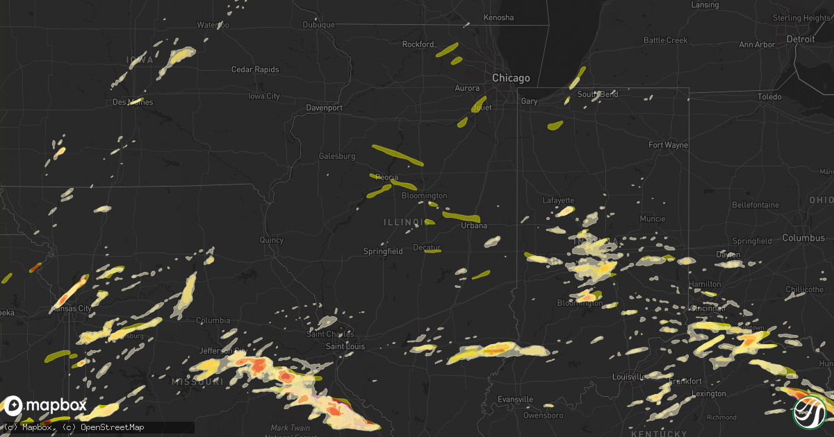
Hail Map in Illinois on April 8, 2015
Get this storm
April 8 map
$229
one time, instant access
Download today. No call, no setup
Keep the $229
Bought the map and want the full workflow? Apply the entire $229 to a subscription within 7 days. None of it is wasted.
Every map, not just this one
This buys you this map. Subscription and you get every map we run, in the markets you choose from a few cities to whole states to nationwide. Plus real-time alerts the moment a storm fires.
Contact data
Name, contact info, occupancy, even credit band for addresses in the footprint. You go from where it hit to who to call.
Become the source they trust
Unlimited branding weather history reports on demand. You already have the documented answer ready for the property owner, and you are the one who showed up with it.
Property data and RoofTrace estimates
Pull up any address you have got, its value and the exact code rules for that jurisdiction, straight from One Click Code. Then RoofTrace estimates the squares, pitch, and roof value, priced the way you price.
Storm reports in Illinois
Illinois
| Date | Description |
|---|---|
| 04/08/20152:38 PM CDT | Power poles leaning over. Via facebook. Time estimated. |
| 04/08/20152:01 PM CDT | A local report indicates 1.00 inch wind near CISNE |
| 04/08/20151:21 PM CDT | A local report indicates 1.00 inch wind near SALEM |
| 04/08/20151:18 PM CDT | A local report indicates 1.00 inch wind near SALEM |
| 04/08/20151:13 PM CDT | A local report indicates 1.00 inch wind near 2 E SALEM |
| 04/08/20157:00 AM CDT | Some tree limbs down with roof damage on houses around town. Late report |
| 04/08/201512:30 AM CDT | A local report indicates 1.00 inch wind near LOCKPORT |
| 04/08/201512:28 AM CDT | A local report indicates 1.00 inch wind near CREST HILL |
| 04/08/201512:07 AM CDT | A local report indicates 1.00 inch wind near SHOREWOOD |
| 04/08/201512:04 AM CDT | Quarter sized hail on bachman rd in seneca township. Reported by mchenry county sheriff...relayed through ema. |
| 04/07/201511:20 PM CDT | Time estimated. |
| 04/07/20159:58 PM CDT | Facebook report. |
All States Impacted by Hail Map on April 8, 2015
Cities Impacted by Hail Map on April 8, 2015
- Campbellsburg, IN
- Walton, WV
- Seymour, IN
- Scipio, IN
- Madrid, IA
- Iaeger, WV
- Mohawk, WV
- Panther, WV
- Clearfield, KY
- Morehead, KY
- Silex, MO
- Harrisonville, MO
- Kingsville, MO
- Pleasant Hill, MO
- Strasburg, MO
- Holden, MO
- Fairmount, IN
- Summitville, IN
- Sheridan, MO
- Sweetwater, OK
- Hammon, OK
- Cheyenne, OK
- Butler, OK
- Sandy Hook, KY
- Martha, KY
- Isonville, KY
- Keaton, KY
- Flatgap, KY
- West Liberty, KY
- Conrad, IA
- Beaman, IA
- Albion, IA
- Gladbrook, IA
- Marshalltown, IA
- Aurora, IN
- Moores Hill, IN
- Bonne Terre, MO
- Valley Center, KS
- Kansas City, KS
- Kansas City, MO
- Louisville, KY
- Freeburg, MO
- Owensville, MO
- Belle, MO
- Mount Sterling, MO
- Chamois, MO
- Linn, MO
- Bland, MO
- Bonnots Mill, MO
- Jefferson City, MO
- Rosebud, MO
- Westphalia, MO
- Loose Creek, MO
- Hermann, MO
- Rhodes, IA
- Melbourne, IA
- State Center, IA
- Middlesex, NC
- Bailey, NC
- Sidell, IL
- Goshen, OH
- Batavia, OH
- Cincinnati, OH
- Williamsburg, OH
- Milford, OH
- Xenia, OH
- Dayton, OH
- Spring Valley, OH
- Bellbrook, OH
- Paducah, TX
- Wallingford, KY
- Vanceburg, KY
- Flemingsburg, KY
- Ewing, KY
- Urich, MO
- Montrose, MO
- Butler, MO
- Garden City, MO
- Cuba, MO
- Briscoe, TX
- Wheeler, TX
- Lamoni, IA
- Chillicothe, OH
- Waverly, OH
- Brownsburg, IN
- Indianapolis, IN
- New Castle, IN
- Lebanon, IN
- Kirklin, IN
- Odin, IL
- Sandoval, IL
- Salem, IL
- Centralia, IL
- Cynthiana, KY
- Monroe City, IN
- Vincennes, IN
- El Dorado Springs, MO
- Hebron, KY
- Burlington, KY
- Saint James, MO
- Leasburg, MO
- Milan, IN
- Sunman, IN
- Osgood, IN
- Cutler, OH
- Prairie Du Chien, WI
- Salvisa, KY
- Lawrenceburg, KY
- Versailles, KY
- Brooksville, KY
- Mayslick, KY
- Germantown, KY
- Ripley, OH
- Manchester, OH
- Augusta, KY
- Aberdeen, OH
- Mount Olivet, KY
- Dover, KY
- Maysville, KY
- Freeburn, KY
- Hardy, KY
- Majestic, KY
- Matewan, WV
- McCarr, KY
- Belfry, KY
- Stopover, KY
- Greenwood, IN
- Bargersville, IN
- New Richmond, IN
- Stedman, NC
- Autryville, NC
- Mount Ayr, IA
- Grant City, MO
- Henley, MO
- Eugene, MO
- Alva, OK
- Burns, KS
- Berry, KY
- Bloomington, IN
- Unionville, IN
- Nashville, IN
- Bethany, MO
- Martinsville, MO
- Olean, MO
- Eldon, MO
- Tuscumbia, MO
- Russellville, MO
- Sanders, KY
- Ghent, KY
- Medicine Lodge, KS
- Saint Francisville, IL
- Sumner, IL
- Central City, KY
- Drakesboro, KY
- Greenville, KY
- Cedar Vale, KS
- Sedan, KS
- Friedheim, MO
- Perryville, MO
- Corning, IA
- Richwoods, MO
- Isabel, KS
- Nashville, KS
- Bunker Hill, IL
- Delbarton, WV
- Girard, KS
- McCune, KS
- Golden Eagle, IL
- Carbon, IN
- Rockville, IN
- Rosedale, IN
- Greenfield, IN
- Slaton, TX
- Blue Creek, OH
- Otway, OH
- West Portsmouth, OH
- Lynx, OH
- West Union, OH
- Stout, OH
- Wilmington, NC
- Sibley, MO
- Richmond, MO
- Orrick, MO
- Camden, MO
- Excelsior Springs, MO
- Buckner, MO
- Vinton, OH
- Bidwell, OH
- Callao, MO
- New Cambria, MO
- Glenwood, WV
- Milton, WV
- Bridgewater, IA
- North Vernon, IN
- Meta, MO
- Vienna, MO
- Dixon, MO
- Rich Hill, MO
- Alton, VA
- Roxboro, NC
- Rougemont, NC
- Dillsboro, IN
- Bennington, IN
- Rising Sun, IN
- Osceola, IA
- Lenore, WV
- Spur, TX
- Dickens, TX
- Ralls, TX
- Crosbyton, TX
- Tahoka, TX
- Justiceburg, TX
- Post, TX
- Odonnell, TX
- Lorenzo, TX
- Afton, TX
- Lamesa, TX
- Wilson, TX
- Greensboro, NC
- Whitsett, NC
- Julian, NC
- Burlington, NC
- Belleville, WV
- Reedsville, OH
- Washington, WV
- Houstonia, MO
- Huddleston, VA
- Hurt, VA
- Altavista, VA
- Evington, VA
- Lynch Station, VA
- Centerview, MO
- Warrensburg, MO
- Snyder, TX
- Lubbock, TX
- Sutherlin, VA
- Milo, MO
- Nevada, MO
- Sheldon, MO
- Norborne, MO
- Braymer, MO
- Osceola, MO
- Quincy, MO
- Warsaw, MO
- Smithville, MO
- Crawfordsville, IN
- Okeana, OH
- Zebulon, NC
- Youngsville, NC
- Louisburg, NC
- Rochester, KY
- Cromwell, KY
- Morgantown, KY
- Dunkirk, IN
- Lebanon Junction, KY
- Shepherdsville, KY
- Clermont, KY
- Coxs Creek, KY
- Allendale, IL
- Bridgeport, IL
- Sims, IL
- Parkersburg, IL
- Calhoun, IL
- Olney, IL
- West Salem, IL
- Clay City, IL
- Mount Carmel, IL
- Cisne, IL
- Keenes, IL
- Mount Erie, IL
- Johnsonville, IL
- Bevier, MO
- Macon, MO
- Slater, MO
- Martinsville, IN
- Saint Elizabeth, MO
- Kaiser, MO
- Glouster, OH
- Arrow Rock, MO
- Glasgow, MO
- Armstrong, MO
- Higbee, MO
- Huntsville, MO
- Salisbury, MO
- Clifton Hill, MO
- Blackwater, MO
- Nelson, MO
- Franklin, MO
- Boonville, MO
- Fayette, MO
- Cedar Hill, MO
- Hagerstown, IN
- Fay, OK
- Custer City, OK
- Taloga, OK
- Thomas, OK
- Putnam, OK
- Shamrock, TX
- Watonga, OK
- Oakwood, OK
- Coldwater, KS
- Sainte Genevieve, MO
- Farmington, MO
- Park Hills, MO
- Niles, MI
- Mayview, MO
- Odessa, MO
- Nelsonville, OH
- Independence, KS
- Sullivan, MO
- High Point, NC
- Jamestown, NC
- Greencastle, IN
- Kempton, IN
- Tipton, IN
- Franklinton, NC
- Atlanta, IN
- Lafayette, IN
- Romney, IN
- Brazil, IN
- Bridgeton, IN
- Bourbon, MO
- Turners Station, KY
- Carrollton, KY
- Bedford, KY
- Campbellsburg, KY
- Mineral Point, MO
- Mobeetie, TX
- Des Moines, IA
- Webbville, KY
- Adams, KY
- Clarkson, KY
- Seiling, OK
- Arnett, OK
- Vici, OK
- Camargo, OK
- Mutual, OK
- Vevay, IN
- Mize, KY
- Hazel Green, KY
- Campton, KY
- Wooldridge, MO
- Taylorsville, KY
- Bloomfield, KY
- Mount Eden, KY
- Shelbyville, KY
- Waddy, KY
- Elkhart, IN
- Perry, OK
- Gerald, MO
- Cadet, MO
- Saint Clair, MO
- Doe Run, MO
- Leslie, MO
- Fredericktown, MO
- Blackwell, MO
- Irondale, MO
- Leadwood, MO
- Saint Mary, MO
- Potosi, MO
- Steelville, MO
- Valles Mines, MO
- De Soto, MO
- South Bend, IN
- Zenda, KS
- Sitka, KY
- Oxford, NC
- Clinton, MO
- Hamersville, OH
- S Coffeyville, OK
- Coffeyville, KS
- Parnell, MO
- Bethel, OH
- Felicity, OH
- Russellville, OH
- Georgetown, OH
- Butler, KY
- Falmouth, KY
- Lewisport, KY
- Maceo, KY
- Rockport, IN
- Yates Center, KS
- Kenney, IL
- Danville, IN
- Ona, WV
- Mattoon, IL
- Sullivan, IL
- Gays, IL
- Humboldt, IL
- Cheney, KS
- Murdock, KS
- Garden Plain, KS
- Goddard, KS
- Colwich, KS
- Andale, KS
- Mount Hope, KS
- Ellston, IA
- Cowgill, MO
- Lawson, MO
- Polo, MO
- Roaring Springs, TX
- Matador, TX
- Frankfort, IN
- Clarks Hill, IN
- Simpsonville, KY
- Coatesville, IN
- Thorntown, IN
- Lockport, KY
- Bethlehem, KY
- Owenton, KY
- Baroda, MI
- Peebles, OH
- Liberty, KS
- Cherryvale, KS
- Ransom, KY
- Wharncliffe, WV
- Hurley, VA
- Williamson, WV
- Saint Olaf, IA
- Tarzan, TX
- Kokomo, IN
- Logan, WV
- Holden, WV
- Notre Dame, IN
- Sun City, KS
- Freedom, OK
- Cunningham, KS
- Wilmore, KS
- Protection, KS
- Spivey, KS
- Lake City, KS
- Buffalo, OK
- Kingman, KS
- Point Pleasant, WV
- Gallipolis, OH
- Cheshire, OH
- Carrollton, MO
- Pittsboro, IN
- Mount Orab, OH
- Jerseyville, IL
- Brighton, IL
- Clinton, NC
- Jetson, KY
- Beaver Dam, KY
- Pilgrim, KY
- Ulysses, KY
- Blaine, KY
- Tomahawk, KY
- Debord, KY
- Inez, KY
- Beauty, KY
- Louisa, KY
- Paintsville, KY
- Tutor Key, KY
- Lovely, KY
- Elkfork, KY
- Lowmansville, KY
- Stambaugh, KY
- River, KY
- Clayton, IN
- Madison, IN
- Cross Plains, IN
- Canaan, IN
- Deputy, IN
- New Palestine, IN
- Adrian, MO
- Sharpsville, IN
- Grafton, IL
- Independence, MO
- Clarinda, IA
- Kittrell, NC
- Quincy, KY
- South Portsmouth, KY
- Siler City, NC
- Liberty, NC
- Staley, NC
- Mooresville, IN
- Morgantown, IN
- Maxton, NC
- Red Springs, NC
- Plainfield, IN
- Arlington, IN
- Rushville, IN
- Millstadt, IL
- East Carondelet, IL
- Dupo, IL
- East Saint Louis, IL
- Sims, NC
- Bunn, NC
- Wilson, NC
- Spring Hope, NC
- Kenly, NC
- Wake Forest, NC
- Lucama, NC
- Fremont, NC
- Orleans, IN
- Salem, IN
- Saint Thomas, MO
- Dewey, OK
- Wann, OK
- Warrenton, MO
- Whiteland, IN
- Franklin, IN
- Olive Hill, KY
- Washington, MO
- Beaufort, MO
- Henryville, IN
- Otisco, IN
- Marysville, IN
- Childress, TX
- McLeansville, NC
- White Oak, NC
- Old Monroe, MO
- Moscow Mills, MO
- O'Fallon, MO
- Benton Harbor, MI
- Ezel, KY
- Wellington, KY
- Springfield, KY
- Willisburg, KY
- Cove City, NC
- Bridgman, MI
- Stevensville, MI
- Falmouth, IN
- Paris, KY
- Saint Pauls, NC
- Parkton, NC
- Sparta, KY
- Fairbank, IA
- Versailles, MO
- Barnett, MO
- Liberty, IN
- Allerton, IL
- Broadlands, IL
- Knob Noster, MO
- Brinktown, MO
- Bronaugh, MO
- Moundville, MO
- Walker, MO
- Piqua, KS
- Bogard, MO
- Longton, KS
- Elk City, KS
- Fredonia, KS
- Mccordsville, IN
- Chatham, VA
- Pikeville, NC
- Stantonsburg, NC
- Fulton, MO
- New Bloomfield, MO
- Lexington, KY
- Bagdad, KY
- Verona, KY
- Independence, KY
- Walton, KY
- Union, KY
- Alexandria, KY
- Morning View, KY
- Mackville, KY
- Chestnut, IL
- Lumberton, NC
- Monrovia, IN
- Brooklyn, IN
- Stilesville, IN
- Camby, IN
- Sherman, IL
- Hale, MO
- Bosworth, MO
- Triplett, MO
- Frankfort, KY
- Lagrange, IN
- Topeka, IN
- Eminence, KY
- Pleasureville, KY
- Stover, MO
- Zearing, IA
- Saint Anthony, IA
- Altoona, KS
- Jayton, TX
- Aspermont, TX
- Sedgewickville, MO
- Bolckow, MO
- Waukomis, OK
- Douglas, OK
- Dover, NC
- Campbellsville, KY
- Magnolia, KY
- Summersville, KY
- Upton, KY
- Sonora, KY
- Buffalo, KY
- Mount Sherman, KY
- Potomac, IL
- Moscow, OH
- Corinth, KY
- De Mossville, KY
- Patriot, IN
- Williamstown, KY
- Carlisle, KY
- Florence, KY
- Latonia, KY
- Warsaw, KY
- California, KY
- Erlanger, KY
- Ft Mitchell, KY
- Foster, KY
- Glencoe, KY
- Neville, OH
- Dry Ridge, KY
- Crittenden, KY
- Sadieville, KY
- Peachland, NC
- Peculiar, MO
- Bates City, MO
- Sharon, KS
- Mendon, MO
- Eau Claire, MI
- Dittmer, MO
- Hamilton, OH
- Harrison, OH
- Fairfield, OH
- Windsor, MO
- Leeton, MO
- Calhoun, MO
- Green Ridge, MO
- Union Hall, VA
- Penhook, VA
- Sandy Level, VA
- Glade Hill, VA
- Wirtz, VA
- Moneta, VA
- Roanoke, IL
- Havana, IL
- Butlerville, IN
- Ravenwood, MO
- Veedersburg, IN
- Crawford, OK
- Leedey, OK
- Durham, OK
- Richards, MO
- Shoals, IN
- Oran, IA
- Sumner, IA
- Connersville, IN
- Brownsville, IN
- Caledonia, MO
- Bismarck, MO
- Clarkton, NC
- Bladenboro, NC
- Semora, NC
- Marshall, MO
- La Monte, MO
- Freeman, MO
- Greenwood, MO
- Hughesville, MO
- Raymore, MO
- Sweet Springs, MO
- Chrisman, IL
- Mulberry, IN
- Snow Hill, NC
- La Grange, NC
- Liscomb, IA
- Somerville, OH
- Middletown, OH
- Kingston, MO
- Chapmanville, WV
- Crum, WV
- Fort Gay, WV
- Dunlow, WV
- Fairland, IN
- Fillmore, IN
- Cloverdale, IN
- Paragon, IN
- Snow Camp, NC
- Ashland, MO
- Peabody, KS
- Newton, KS
- Elsberry, MO
- Gladys, VA
- Thaxton, VA
- Bedford, VA
- Morrison, MO
- Alma, IL
- Kinmundy, IL
- La Porte, IN
- Hardtner, KS
- Kiowa, KS
- Trenton, IL
- Excello, MO
- Anabel, MO
- Fairmount, IL
- Hume, IL
- Newman, IL
- Indianola, IL
- South Boston, VA
- Goldsboro, NC
- Ionia, IA
- Plainfield, IA
- Nashua, IA
- New Hampton, IA
- Garwin, IA
- Darlington, SC
- Sedalia, MO
- Blue Ridge, VA
- Fincastle, VA
- Buchanan, VA
- Montvale, VA
- Bellflower, MO
- Lawrenceburg, IN
- New Virginia, IA
- Truro, IA
- Mindenmines, MO
- Liberal, MO
- Harrodsburg, KY
- Camdenton, MO
- Roach, MO
- Friendship, OH
- South Shore, KY
- Elizabethtown, NC
- Vesuvius, VA
- Bunnlevel, NC
- Erwin, NC
- Collins, MO
- Stockton, MO
- Hodgenville, KY
- Lathrop, MO
- Saint Louis, MO
- Archie, MO
- Washington, IN
- Wheatland, IN
- Otwell, IN
- Petersburg, IN
- Montgomery, IN
- Decker, IN
- Andrews, TX
- Carlyle, IL
- Kell, IL
- Iuka, IL
- Trenton, NC
- Gilliam, MO
- Pleasant Garden, NC
- Neosho Falls, KS
- Pleasant Hill, IA
- Morven, NC
- Blackburn, MO
- Higginsville, MO
- Concordia, MO
- Straughn, IN
- Humboldt, KS
- Chanute, KS
- Genoa, NE
- Wauzeka, WI
- Steuben, WI
- Union, MO
- Pawhuska, OK
- Shidler, OK
- Maryville, MO
- Noble, IL
- Kinston, NC
- Havana, KS
- Caney, KS
- Shelburn, IN
- Sheridan, IN
- Carmel, IN
- Lizton, IN
- Avon, IN
- Altoona, IA
- Ellettsville, IN
- Spencer, IN
- Gosport, IN
- Holt, MO
- Whitestown, IN
- Jamestown, IN
- Quincy, IN
- New Ross, IN
- Zionsville, IN
- North Salem, IN
- Beech Grove, IN
- West Newton, IN
- Salyersville, KY
- New Richmond, OH
- Brookville, IN
- Brussels, IL
- Loretto, KY
- Bardstown, KY
- Coon Valley, WI
- Rayville, MO
- Jonesville, KY
- Nabb, IN
- Underwood, IN
- Wilsondale, WV
- Switzer, WV
- Kermit, WV
- Genoa, WV
- Dingess, WV
- Grayson, KY
- Breeden, WV
- Farina, IL
- Ingraham, IL
- Hope, IN
- Hartsville, IN
- Columbus, IN
- Camden, OH
- Eaton, OH
- Reydon, OK
- Ames, IA
- Nevada, IA
- Calmar, IA
- Fort Atkinson, IA
- Copan, OK
- Bartlesville, OK
- Niotaze, KS
- Centerville, IN
- Greens Fork, IN
- Milton, IN
- Cambridge City, IN
- Omar, WV
- Chauncey, WV
- Sayre, OK
- Canton, OK
- Mclean, TX
- Emerson, KY
- Darlington, WI
- Osage Beach, MO
- Belgrade, MO
- Uniontown, MO
- Luebbering, MO
- Grubville, MO
- Ironton, MO
- Lonedell, MO
- Patton, MO
- Belleview, MO
- Davisville, MO
- Cee Vee, TX
- Hamilton, MO
- Cedar Point, KS
- Chilhowee, MO
- Leon, WV
- Gail, TX
- Newkirk, OK
- Maple City, KS
- Kaw City, OK
- Dexter, KS
- Odessa, TX
- Bonner Springs, KS
- Liberty, MO
- Kearney, MO
- Carthage, IN
- Eureka, KS
- Waynetown, IN
- Roland, IA
- McCallsburg, IA
- Whitewater, KS
- Redfield, KS
- Hepler, KS
- Savonburg, KS
- Uniontown, KS
- Branford, FL
- Loveland, OH
- Berger, MO
- New Haven, MO
- New Hampton, MO
- Versailles, IN
- Holton, IN
- New Providence, IA
- Lynchburg, OH
- Hillsboro, OH
- Troy, MO
- Winfield, MO
- Crestwood, KY
- Tina, MO
- Bondurant, IA
- Man, WV
- Sarah Ann, WV
- Lyburn, WV
- Mammoth Cave, KY
- Edinburgh, IN
- Oronoco, MN
- Bristol, IN
- Glenwood, IN
- Morristown, IN
- Lebanon, KY
- Hebron, IL
- Bartlett, KS
- Oswego, KS
- Edna, KS
- Wagener, SC
- Salley, SC
- Chapel Hill, NC
- Wilkinson, IN
- Markleville, IN
- Pendleton, IN
- Plattsburg, MO
- Trimble, MO
- Kelley, IA
- Fortville, IN
- Waterford, OH
- Beverly, OH
- Elsah, IL
- Saint Charles, MO
- Portage Des Sioux, MO
- Lincoln, MO
- Edwards, MO
- Ralston, OK
- Fairfax, OK
- South Salem, OH
- Bainbridge, OH
- Neodesha, KS
- Moline, KS
- Benedict, KS
- Elk Falls, KS
- Thayer, KS
- Claremore, OK
- Downs, IL
- Bloomington, IL
- Loogootee, IN
- Berrien Springs, MI
- Covington, IN
- Cameron, NC
- Mecca, IN
- Montezuma, IN
- Staffordsville, KY
- Hagerhill, KY
- Oil Springs, KY
- Weaubleau, MO
- Wheatland, MO
- Ackley, IA
- Murray, IA
- Wichita, KS
- Maize, KS
- Marion, IN
- Leitchfield, KY
- Bee Spring, KY
- Gallatin, MO
- Rolla, MO
- Watervliet, MI
- Schell City, MO
- Harwood, MO
- Fluvanna, TX
- Cottageville, WV
- Ripley, WV
- Evans, WV
- Greensburg, IN
- Westport, IN
- Farmer City, IL
- Roseboro, NC
- Dunmor, KY
- Lewisburg, KY
- Ingalls, IN
- Blue Springs, MO
- Grain Valley, MO
- Lodi, WI
- Dane, WI
- Angola, IN
- Westgate, IA
- Maynard, IA
- Rockville, MO
- Wingate, IN
- Sedgwick, KS
- Mount Pulaski, IL
- Shirley, IN
- Milroy, IN
- Neoga, IL
- Amoret, MO
- Stewart, OH
- Kenna, WV
- Liberty, WV
- Forest Hills, KY
- Knightstown, IN
- Charlottesville, IN
- Wentzville, MO
- Lake Saint Louis, MO
- Fraziers Bottom, WV
- Ashton, WV
- Crown City, OH
- Gallipolis Ferry, WV
- Southside, WV
- Apple Grove, WV
- Pekin, IN
- Oregon, MO
- Spring Lake, NC
- Jamestown, OH
- Lester, WV
- Slab Fork, WV
- Gravois Mills, MO
- Hawk Point, MO
- Lillington, NC
- Three Oaks, MI
- New Buffalo, MI
- Sawyer, MI
- Buchanan, MI
- Woodburn, IA
- Cannelburg, IN
- Woodward, IA
- Granger, IA
- Bonnieville, KY
- Newton Grove, NC
- Vichy, MO
- Petersburg, KY
- Clarence, MO
- Oelwein, IA
- South Williamson, KY
- Sidney, KY
- Prestonsburg, KY
- Boons Camp, KY
- Warfield, KY
- Alton, IL
- Godfrey, IL
- Welch, TX
- Melbourne, KY
- North Liberty, IN
- Fairfield, IL
- Geff, IL
- Flora, IL
- Rinard, IL
- Pedro, OH
- Vallonia, IN
- Florissant, MO
- Hazelwood, MO
- Bainbridge, IN
- Muscoda, WI
- Lone Rock, WI
- Dubuque, IA
- Brumley, MO
- Ulman, MO
- Sardinia, OH
- Hortense, GA
- Woodward, OK
- Lesage, WV
- Traer, IA
- Marceline, MO
- Batchtown, IL
- Hardin, IL
- Grundy Center, IA
- Eldora, IA
- Lance Creek, WY
- Lusk, WY
- Le Roy, IL
- Bishopville, SC
- Mayesville, SC
- Lexington, VA
- Tollesboro, KY
- Wendell, NC
- Hewett, WV
- Jeffrey, WV
- Miamisburg, OH
- Greenup, KY
- Warren, IN
- Oak Grove, MO
- Hudson, IA
- New Haven, KY
- Heyworth, IL
- Shirley, IL
- Lake Ozark, MO
- Frohna, MO
- Robertsville, MO
- Fletcher, MO
- Catawissa, MO
- Rocky Mount, MO
- Pacific, MO
- Arnold, MO
- House Springs, MO
- Villa Ridge, MO
- High Ridge, MO
- Imperial, MO
- Rhineland, MO
- Jasper, IN
- Patoka, IL
- Sparta, IL
- Baldwin, IL
- Ossian, IA
- Creedmoor, NC
- Hanover, IN
- New Washington, IN
- Freetown, IN
- Villisca, IA
- Lumber Bridge, NC
- Vass, NC
- Spring Green, WI
- Shelbyville, IN
- Boggstown, IN
- Fayette, IA
- Mcconnelsville, OH
- Malta, OH
- Weldon, IA
- Van Wert, IA
- Shobonier, IL
- Vandalia, IL
- Aviston, IL
- Avon, IL
- Hubbard, IA
- Pembroke, NC
- Tebbetts, MO
- Holts Summit, MO
- Cook, NE
- Dallas Center, IA
- Hartford City, IN
- Xenia, IL
- Oxford, OH
- Winchester, OH
- Evansdale, IA
- Dunkerton, IA
- Raymond, IA
- Waterloo, IA
- Cambridge, WI
- Ridgeway, MO
- Burbank, OK
- Reed, KY
- Fort Supply, OK
- Borden, IN
- Bluford, IL
- Mount Vernon, IL
- New Florence, MO
- Linden, IN
- Deerfield, WI
- Cantrall, IL
- Springfield, IL
- Richmond, IL
- Sterling, NE
- Tecumseh, NE
- Sapulpa, OK
- Nodaway, IA
- Twin Lakes, WI
- Genoa City, WI
- Germantown, OH
- Amanda, OH
- Laurelville, OH
- Fayetteville, NC
- Ironton, OH
- Appleton City, MO
- Steedman, MO
- Columbia, IL
- Austin, IN
- Scottsburg, IN
- Council, NC
- Mooreland, OK
- Hillsdale, IN
- Nineveh, IN
- Henderson, NC
- Morris, IL
- New Troy, MI
- Saint Joseph, MI
- Hanna, IN
- La Crosse, IN
- Wanatah, IN
- Kouts, IN
- Shorewood, IL
- Lemont, IL
- Minooka, IL
- Channahon, IL
- Crest Hill, IL
- Joliet, IL
- Plainfield, IL
- Romeoville, IL
- Lockport, IL
- Hampshire, IL
- Huntley, IL
- Burlington, IL
- Gilberts, IL
- Kingston, IL
- Belvidere, IL
- Garden Prairie, IL
- Genoa, IL
- Woodstock, IL
- Marengo, IL
- Union, IL
- Stone, KY
- Huddy, KY
- Pinsonfork, KY
- Phelps, KY
- Jolo, WV
- Raysal, WV
- Oak Ridge, MO
- Bloomsdale, MO
- French Village, MO
- Old Appleton, MO
- Hillsboro, MO
- Elmwood, IL
- Peoria, IL
- Trivoli, IL
- Hanna City, IL
- Mahomet, IL
- Dewey, IL
- Urbana, IL
- Mansfield, IL
- Champaign, IL
- Thomasboro, IL
- Carlock, IL
- East Peoria, IL
- Danvers, IL
- Mackinaw, IL
- Morton, IL
- Deer Creek, IL
- Congerville, IL
- Goodfield, IL
- Washington, IL
- Benson, IL
- Chillicothe, IL
- Speer, IL
- Washburn, IL
- Sparland, IL
- Wyoming, IL
- Toulon, IL
- Minonk, IL
- Lacon, IL
- Edelstein, IL
- Argenta, IL
- Dalton City, IL
- Decatur, IL
- Lovington, IL
- Mt Zion, IL
- Pekin, IL
- Groveland, IL
- Canton, IL
- Manito, IL
- Ashmore, IL
- Charleston, IL
- Clinton, IL
- Holton, KS
- Muscotah, KS
- Amsterdam, MO
- Louisburg, KS
- Drexel, MO
- Osawatomie, KS
- Paola, KS
- Goff, KS
- Wetmore, KS
- Fort Scott, KS
- Erie, KS
- Stark, KS
- Cummings, KS
- Troy, KS
- Atchison, KS
- Walnut, KS
- Garland, KS


