Hail Map in Chesterfield, MO on April 7, 2015
The weather event in Chesterfield, MO on April 7, 2015 includes Hail map. 9 states and 616 cities were impacted and suffered possible damage. The total estimated number of properties impacted is 11,432.
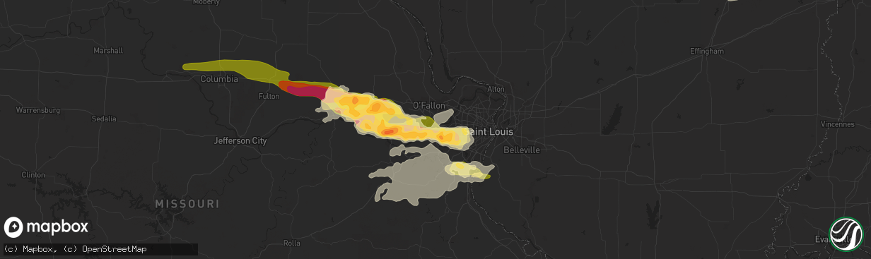
Hail
11,432
Estimated number of impacted properties by a 1.00" hail or larger4,443
Estimated number of impacted properties by a 1.75" hail or larger0
Estimated number of impacted properties by a 2.50" hail or largerStorm reports in Chesterfield, MO
Chesterfield, MO
| Date | Description |
|---|---|
| 04/07/20159:30 AM CDT | A local report indicates 1.00 inch wind near CHESTERFIELD |
| 04/07/20159:28 AM CDT | Hail size ranged from dime-size to quarter-size in chesterfield. |
All States Impacted by Hail Map on April 7, 2015
All Cities Impacted by Hail Map on April 7, 2015
- Steen, MN
- Willows, CA
- Cisne, IL
- Fairfield, IL
- Mount Union, IA
- Mount Pleasant, IA
- Yarmouth, IA
- Blair, SC
- Blackburn, MO
- Sweet Springs, MO
- Clinton, IL
- Bronson, KS
- Uniontown, KS
- Fenton, MO
- Imperial, MO
- House Springs, MO
- Columbia, IL
- Saint Louis, MO
- Barnhart, MO
- Valmeyer, IL
- Waterloo, IL
- Arnold, MO
- High Ridge, MO
- Blythewood, SC
- Bonnie, IL
- Belle Rive, IL
- Ina, IL
- Edwardsville, IL
- Cleveland, MO
- Peculiar, MO
- Sullivan, MO
- Dittmer, MO
- Robertsville, MO
- Grubville, MO
- Hillsboro, MO
- Cedar Hill, MO
- Lonedell, MO
- Catawissa, MO
- Luebbering, MO
- Union, MO
- Villa Ridge, MO
- Saint Clair, MO
- Neodesha, KS
- Soldier, KS
- Circleville, KS
- Roachdale, IN
- Russellville, IN
- Ladoga, IN
- Lowpoint, IL
- Metamora, IL
- Mt Zion, IL
- Decatur, IL
- Poseyville, IN
- Eureka, MO
- Pacific, MO
- Dana, IN
- Chrisman, IL
- Thayer, KS
- Parsons, KS
- Dennis, KS
- Altoona, KS
- Cherryvale, KS
- Whitmire, SC
- Mattoon, IL
- Westfield, IL
- Kansas, IL
- Charleston, IL
- Casey, IL
- Lerna, IL
- Martinsville, IL
- Ashmore, IL
- Wentzville, MO
- Berger, MO
- Saint Peters, MO
- Rhineland, MO
- Wright City, MO
- Labadie, MO
- Marthasville, MO
- Saint Charles, MO
- Warrenton, MO
- Defiance, MO
- Saint Albans, MO
- Ballwin, MO
- Wildwood, MO
- Washington, MO
- New Florence, MO
- Chesterfield, MO
- Jonesburg, MO
- New Haven, MO
- Hermann, MO
- Truesdale, MO
- Foristell, MO
- Valley Park, MO
- Augusta, MO
- High Hill, MO
- Louisburg, KS
- Rantoul, KS
- Osawatomie, KS
- Ottawa, KS
- Paola, KS
- Lane, KS
- Princeton, KS
- Fontana, KS
- Leavenworth, IN
- English, IN
- Weldon, IL
- Fort Scott, KS
- Garland, KS
- Bronaugh, MO
- Arcadia, KS
- Jackson, MN
- Farmer City, IL
- Mahomet, IL
- Mansfield, IL
- Charlestown, IN
- Marysville, IN
- Cayuga, IN
- Hillsdale, IN
- Lane, IL
- Dewitt, IL
- Tennyson, IN
- Lynnville, IN
- Boonville, IN
- Elberfeld, IN
- Chandler, IN
- Sumner, IA
- Westgate, IA
- Cherryville, MO
- Davisville, MO
- Steelville, MO
- Tell City, IN
- Lacon, IL
- Washburn, IL
- Richmond, KY
- Nicholasville, KY
- Lancaster, KY
- Morton, IL
- Deer Creek, IL
- Danvers, IL
- Mackinaw, IL
- Appleton City, MO
- Osceola, MO
- Lowry City, MO
- Herculaneum, MO
- Pevely, MO
- New London, IA
- Mound Valley, KS
- Benedict, KS
- Independence, KS
- Corydon, IN
- Harrisonville, MO
- Greenville, IN
- Butler, MO
- Foster, MO
- Amoret, MO
- Pleasanton, KS
- Pittsboro, IN
- Brownsburg, IN
- Walnut Hill, IL
- Centralia, IL
- Dix, IL
- Potosi, MO
- Veedersburg, IN
- Hillsboro, IN
- Delavan, IL
- Minier, IL
- Hopedale, IL
- Wetmore, KS
- Goff, KS
- Marshall, IN
- Montezuma, IN
- Clinton, IN
- Bloomingdale, IN
- Mecca, IN
- Rosedale, IN
- Rockville, IN
- New Albany, IN
- Floyds Knobs, IN
- Celestine, IN
- Eckerty, IN
- Grantsburg, IN
- Schnellville, IN
- Birdseye, IN
- Huntingburg, IN
- Saint Anthony, IN
- Saint Croix, IN
- Fayette, IA
- Arlington, IA
- Atchison, KS
- Frankfort, KY
- Bagdad, KY
- Renwick, IA
- Kanawha, IA
- Lexington, IL
- Colfax, IL
- Anchor, IL
- Cropsey, IL
- Odessa, MO
- Harrodsburg, KY
- Downs, IL
- Heyworth, IL
- Le Roy, IL
- Marceline, MO
- Carlisle, SC
- De Soto, MO
- Griffin, IN
- Stanford, IL
- Erie, KS
- Stark, KS
- Columbia, SC
- Sainte Genevieve, MO
- Bristow, IN
- Branchville, IN
- Hartland, MN
- Geff, IL
- Concordia, MO
- Elmwood, IL
- Brimfield, IL
- Hanna City, IL
- Trivoli, IL
- Union, SC
- Mascoutah, IL
- Summerfield, IL
- Lebanon, IL
- Trenton, IL
- White Heath, IL
- Iowa City, IA
- Lone Tree, IA
- Kingman, IN
- Wayland, IA
- Bradford, IL
- Williamsfield, IL
- Yates City, IL
- Redfield, KS
- Tamaroa, IL
- Gerald, MO
- Rosebud, MO
- Fairfield, IA
- Brighton, IA
- Magnolia, KY
- Brookston, IN
- Battle Ground, IN
- Holton, KS
- North Salem, IN
- Hepler, KS
- Walnut, KS
- Allerton, IL
- Hume, IL
- Broadlands, IL
- Sidell, IL
- Longview, IL
- Chester, SC
- Cummings, KS
- Rushville, MO
- Troy, KS
- Jonesville, SC
- Adrian, MO
- Oelwein, IA
- Fort Branch, IN
- New Harmony, IN
- Owensville, IN
- Cynthiana, IN
- Prospect, KY
- Goshen, KY
- La Fayette, IL
- Galva, IL
- Wells, MN
- Alden, MN
- McLean, IL
- Bloomfield, IA
- Hedrick, IA
- Batavia, IA
- Ottumwa, IA
- Agency, IA
- Blakesburg, IA
- Orangeburg, SC
- North, SC
- Ridgeway, SC
- Farmington, IL
- Lincoln, MO
- Bennett, IA
- Tipton, IA
- Oneida, IL
- Altona, IL
- Chester, IL
- Campbell Hill, IL
- Steeleville, IL
- Percy, IL
- Champaign, IL
- Towanda, IL
- Pacolet, SC
- Spartanburg, SC
- Fulton, KS
- Onaga, KS
- Sebree, KY
- Morganfield, KY
- Dixon, KY
- McCune, KS
- Chanute, KS
- Muscotah, KS
- Effingham, KS
- Mineral Point, MO
- Cadet, MO
- Bonne Terre, MO
- Larchwood, IA
- Velpen, IN
- Breese, IL
- Highland, IL
- Aviston, IL
- Bainbridge, IN
- Greencastle, IN
- Santa Claus, IN
- Ferdinand, IN
- Haubstadt, IN
- Leopold, IN
- Saint Meinrad, IN
- Lamar, IN
- Dale, IN
- Evansville, IN
- Lincoln City, IN
- Chrisney, IN
- Gentryville, IN
- Evanston, IN
- Cannelton, IN
- Oswego, KS
- Chestnut, IL
- Philo, IL
- Urbana, IL
- Sidney, IL
- Buffalo, SC
- Bonnieville, KY
- Lockridge, IA
- Alma, KS
- Golden Gate, IL
- Mount Erie, IL
- Salem, MO
- French Village, MO
- Bloomsdale, MO
- Central, IN
- Battletown, KY
- Mauckport, IN
- Emden, IL
- Lincoln, IL
- Armington, IL
- Atlanta, IL
- Lawndale, IL
- Hartsburg, IL
- Peoria, IL
- Archie, MO
- Drexel, MO
- Park Hills, MO
- Winfield, IA
- Tremont, IL
- Pekin, IL
- Manito, IL
- Roanoke, IL
- Lugoff, SC
- Amsterdam, MO
- Mapleton, KS
- Savonburg, KS
- Elsmore, KS
- Moran, KS
- Glasford, IL
- Washington, IA
- San Jose, IL
- Green Valley, IL
- Belleville, IL
- Stockport, IA
- Blackstock, SC
- Keenes, IL
- Johnsonville, IL
- Sims, IL
- Benson, IL
- Minonk, IL
- Gray Summit, MO
- Norborne, MO
- Libertyville, IA
- Eldon, IA
- Monticello, IL
- De Land, IL
- Higginsville, MO
- Thomasboro, IL
- Dewey, IL
- Ainsworth, IA
- Hayward, MN
- Glenville, MN
- Albert Lea, MN
- Groveland, IL
- Topeka, IL
- Holden, MO
- Liverpool, IL
- Lewistown, IL
- Coulterville, CA
- Goodfield, IL
- Sellersburg, IN
- Irmo, SC
- Winnsboro, SC
- Farmington, MO
- Monmouth, IL
- Princeville, IL
- Mayview, MO
- Bates City, MO
- Warrensburg, MO
- Centerview, MO
- Ollie, IA
- Irvington, IL
- Hoyleton, IL
- Villa Grove, IL
- Camargo, IL
- Delphi, IN
- Richwoods, MO
- Blackwell, MO
- Bourbon, MO
- East Peoria, IL
- Trilla, IL
- Paris, IL
- Bloomington, IL
- Normal, IL
- Wyoming, IL
- Speer, IL
- Lancaster, KS
- Valley Falls, KS
- Wathena, KS
- Saint Joseph, MO
- Oakwood, IL
- Waterford, CA
- Sparland, IL
- Chillicothe, IL
- Bradgate, IA
- Rutland, IA
- Albers, IL
- Bartelso, IL
- Lizton, IN
- Oakland City, IN
- Stendal, IN
- Elgin, SC
- Crossville, IL
- Gridley, IL
- Hudson, IL
- El Paso, IL
- Drakesville, IA
- Packwood, IA
- Kell, IL
- Iuka, IL
- Salem, IL
- Fisher, IL
- Morning Sun, IA
- La Cygne, KS
- Freeman, MO
- Wellsville, KS
- La Place, IL
- Hammond, IL
- Deepwater, MO
- Clinton, MO
- Dearborn, MO
- Faucett, MO
- Toulon, IL
- West Branch, IA
- West Liberty, IA
- Carlyle, IL
- Salem, IA
- Danville, IA
- Havensville, KS
- Corning, KS
- East Saint Louis, IL
- Millstadt, IL
- Sadorus, IL
- Carlock, IL
- Leslie, MO
- Beaufort, MO
- Sulphur, IN
- Jasper, IN
- Milltown, IN
- Taswell, IN
- New Ross, IN
- Lebanon, IN
- Jamestown, IN
- Belgrade, MO
- Brownsville, KY
- Waltonville, IL
- Scheller, IL
- Oakville, IA
- Mediapolis, IA
- Wapella, IL
- Sandoval, IL
- Mendon, MO
- Riverside, IA
- Ceylon, MN
- Fairmont, MN
- Pomaria, SC
- Clinton, SC
- Olds, IA
- O'Fallon, MO
- Sigourney, IA
- Platte City, MO
- Bismarck, MO
- Saint Mary, MO
- Oakdale, CA
- Princeton, IN
- Palmyra, IN
- Mound City, KS
- Kenney, IL
- Waynesville, IL
- Bondville, IL
- Arrowsmith, IL
- Seymour, IL
- Rantoul, IL
- Bellflower, IL
- Gilman, IL
- Stamping Ground, KY
- Waveland, IN
- Kingsville, MO
- Festus, MO
- Readlyn, IA
- Centerville, KS
- Parker, KS
- Victoria, IL
- Ellery, IL
- Borden, IN
- Varna, IL
- Easton, IL
- Keota, IA
- South Pekin, IL
- Congerville, IL
- Granada, MN
- Winnebago, MN
- Fredonia, KS
- Fayette, MO
- Alexander, IA
- Forest City, IL
- Burgin, KY
- Danville, KY
- Armstrong, IL
- Ogden, IL
- Fithian, IL
- Odin, IL
- Pendleton, KY
- La Grange, KY
- Smithfield, KY
- Troy, IL
- Saint Jacob, IL
- Richland, IA
- La Grange, CA
- Lodi, CA
- Sheffield, IA
- Latimer, IA
- Fair Oaks, IN
- Alma, MO
- Elk City, KS
- Farlington, KS
- Humboldt, KS
- Pocahontas, IA
- Boston, KY
- Bardstown, KY
- Horton, KS
- Saint Joseph, IL
- Penfield, IL
- Independence, MO
- Ellsworth, IL
- Maquon, IL
- Lebanon, KY
- Wapello, IA
- Keithsburg, IL
- Seaton, IL
- Sperry, IA
- Unionville, IA
- West Chester, IA
- Eastover, SC
- Marengo, IN
- Rutland, IL
- Franklin, MO
- Mount Carmel, IL
- Austin, MN
- Waltham, MN
- Sumter, SC
- Hoopeston, IL
- Cutler, IL
- Fredericktown, MO
- Galesburg, IL
- Alexis, IL
- O'Fallon, IL
- Fairview Heights, IL
- Eminence, KY
- New Castle, KY
- Rio, IL
- North Henderson, IL
- Xenia, IL
- Clarence, IA
- Harper, IA
- Canton, IL
- Mason City, IL
- Eureka, IL
- Malta Bend, MO
- Cherokee, KS
- Frontenac, KS
- Pittsburg, KS
- Girard, KS
- Mindenmines, MO
- Jasper, MO
- Liberal, MO
- Oronogo, MO
- Asbury, MO
- Lamar, MO
- Auxvasse, MO
- Kingdom City, MO
- Montgomery City, MO
- Rocheport, MO
- Hallsville, MO
- Fulton, MO
- Williamsburg, MO
- Centralia, MO
- New Franklin, MO
- Columbia, MO
- Batesburg, SC
- Leesville, SC
- Saluda, SC


