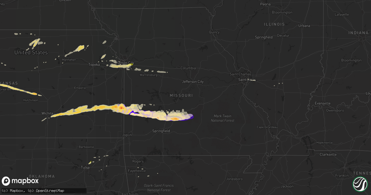
Hail Map in Missouri on April 7, 2013
Get this storm
April 7 map
$229
one time, instant access
Download today. No call, no setup
Keep the $229
Bought the map and want the full workflow? Apply the entire $229 to a subscription within 7 days. None of it is wasted.
Every map, not just this one
This buys you this map. Subscription and you get every map we run, in the markets you choose from a few cities to whole states to nationwide. Plus real-time alerts the moment a storm fires.
Contact data
Name, contact info, occupancy, even credit band for addresses in the footprint. You go from where it hit to who to call.
Become the source they trust
Unlimited branding weather history reports on demand. You already have the documented answer ready for the property owner, and you are the one who showed up with it.
Property data and RoofTrace estimates
Pull up any address you have got, its value and the exact code rules for that jurisdiction, straight from One Click Code. Then RoofTrace estimates the squares, pitch, and roof value, priced the way you price.
Storm reports in Missouri
Missouri
| Date | Description |
|---|---|
| 04/07/20136:54 PM CDT | A local report indicates 1.75 inch wind near STOCKTON |
| 04/07/20136:35 PM CDT | A local report indicates 1.75 inch wind near JERICO SPRINGS |
| 04/07/20136:12 PM CDT | A local report indicates 1.75 inch wind near SHELDON |
| 04/07/20136:07 PM CDT | Reported of breaking windows |
| 04/07/20136:01 PM CDT | Highway bb covered by hail. Delayed report. |
| 04/06/20138:45 PM CDT | A local report indicates 1.00 inch wind near LEBANON |
| 04/06/20138:31 PM CDT | Emergency manager reporting numerous windows damaged due to golfball sized hail. |
| 04/06/20138:31 PM CDT | Golf ball sized hail covering the ground. |
| 04/06/20138:27 PM CDT | A local report indicates 1.75 inch wind near CONWAY |
| 04/06/20138:09 PM CDT | A local report indicates 1.00 inch wind near 5 SSE INDEPENDENCE |
| 04/06/20138:01 PM CDT | A local report indicates 1.00 inch wind near INDEPENDENCE |
| 04/06/20138:00 PM CDT | A local report indicates 1.00 inch wind near BUFFALO |
| 04/06/20137:57 PM CDT | Quarter size hail observed at 59th and sterling. |
| 04/06/20137:50 PM CDT | A local report indicates 1.75 inch wind near HALF WAY |
| 04/06/20137:32 PM CDT | A local report indicates 1.75 inch wind near BOLIVAR |
| 04/06/20137:30 PM CDT | A local report indicates 1.75 inch wind near BOLIVAR |
| 04/06/20137:23 PM CDT | A local report indicates 1.00 inch wind near 3 NW BOLIVAR |
| 04/06/20137:22 PM CDT | A local report indicates 1.00 inch wind near FAIR PLAY |
| 04/06/20137:15 PM CDT | A local report indicates 1.50 inch wind near 2 NW ALDRICH |
Cities Impacted by Hail Map on April 7, 2013
- Fort Riley, KS
- Riley, KS
- Centralia, IL
- Jerico Springs, MO
- Plato, MO
- Fort Leonard Wood, MO
- Beaumont, KS
- Leon, KS
- Urbana, MO
- Milo, MO
- Toronto, KS
- Morrisville, MO
- Dunnegan, MO
- Brighton, MO
- Aldrich, MO
- Augusta, KS
- Humansville, MO
- Elsmore, KS
- Wichita, KS
- Hepler, KS
- Rose Hill, KS
- Harwood, MO
- Bronson, KS
- Fredonia, KS
- Windyville, MO
- Uniontown, KS
- Andover, KS
- Arcola, MO
- Lamar, MO
- Iola, KS
- Richland, MO
- Latham, KS
- Richards, MO
- Stockton, MO
- Phillipsburg, MO
- Derby, KS
- Fort Scott, KS
- Garland, KS
- Walker, MO
- Yates Center, KS
- Waynesville, MO
- Grovespring, MO
- Dadeville, MO
- Rosalia, KS
- Piedmont, KS
- Fair Grove, MO
- Niangua, MO
- Moundville, MO
- Fair Play, MO
- El Dorado Springs, MO
- Eureka, KS
- Redfield, KS
- Deerfield, MO
- Bolivar, MO
- Neal, KS
- Long Lane, MO
- Moran, KS
- Flemington, MO
- La Harpe, KS
- Laquey, MO
- Elkland, MO
- Lynchburg, MO
- Piqua, KS
- Buffalo, MO
- Half Way, MO
- Virgil, KS
- Tunas, MO
- Falcon, MO
- Conway, MO
- Sheldon, MO
- Nevada, MO
- Humboldt, KS
- Severy, KS
- Bronaugh, MO
- Lebanon, MO
- Polk, MO
- Louisburg, MO
- Fall River, KS
- Chase, KS
- Shawnee, KS
- Hoisington, KS
- Great Bend, KS
- Bonner Springs, KS
- De Soto, KS
- Independence, MO
- Leawood, KS
- Prairie Village, KS
- Kansas City, KS
- Blue Springs, MO
- Overland Park, KS
- Lenexa, KS
- Tonganoxie, KS
- Lees Summit, MO
- Kansas City, MO
- Mission, KS
- Linwood, KS
- Osceola, MO
- Wakefield, KS
- Sweet Springs, MO
- La Monte, MO
- Concordia, MO
- Houstonia, MO
- Hughesville, MO
- Knob Noster, MO
- Adair, OK
- Haysville, KS
- Clearwater, KS
- Jamestown, KS
- Belleville, KS
- Scandia, KS
- Norway, KS
- Concordia, KS
- Jewell, KS
- Inman, KS
- Denton, KS
- Lancaster, KS
- Manhattan, KS
- Olsburg, KS
- Westmoreland, KS
- Little River, KS
- Lyons, KS
- Albert, KS
- Bison, KS
- Alexander, KS
- Bazine, KS
- La Crosse, KS
- Olmitz, KS
- Otis, KS
- Ellinwood, KS
- Raymond, KS
- Sterling, KS
- Claflin, KS
- Winslow, AR
- West Fork, AR
- Beloit, KS
- Owasso, OK
- Moundridge, KS
- Paradise, KS
- Oskaloosa, KS
- Winchester, KS
- Soldier, KS
- Havensville, KS
- Corning, KS
- Onaga, KS
- East Saint Louis, IL
- Locust Grove, OK
- Big Cabin, OK
- Russell, KS
- Basehor, KS
- Tescott, KS
- Perry, KS
- Sedalia, MO
- Burr Oak, KS
- Weaubleau, MO
- Collins, MO
- Clyde, KS
- Minneapolis, KS
- Hoyleton, IL
- Valley Falls, KS
- Huntsville, AR
- Witter, AR
- Chelsea, OK
- Claremore, OK
- Leavenworth, KS
- Saint Louis, MO
- Courtland, KS
- Esbon, KS
- Ozawkie, KS
- Chouteau, OK
- Centerview, MO
- Warrensburg, MO
- Meriden, KS
- Hindsville, AR
- Elkins, AR
- Fayetteville, AR
- Caseyville, IL
- Fairview Heights, IL
- O'Fallon, IL
- Brookville, KS
- Eldridge, MO
- Stoutland, MO
- McLouth, KS
- Ponca, AR
- Circleville, KS
- Goff, KS
- Oak Grove, MO
- Lone Jack, MO
- Inola, OK
- Greenleaf, KS
- Grandview, MO
- Springdale, AR
- Grain Valley, MO
- Holden, MO
- Odessa, MO
- Bates City, MO
- Grantville, KS
- Lawrence, KS
- Collinsville, OK


