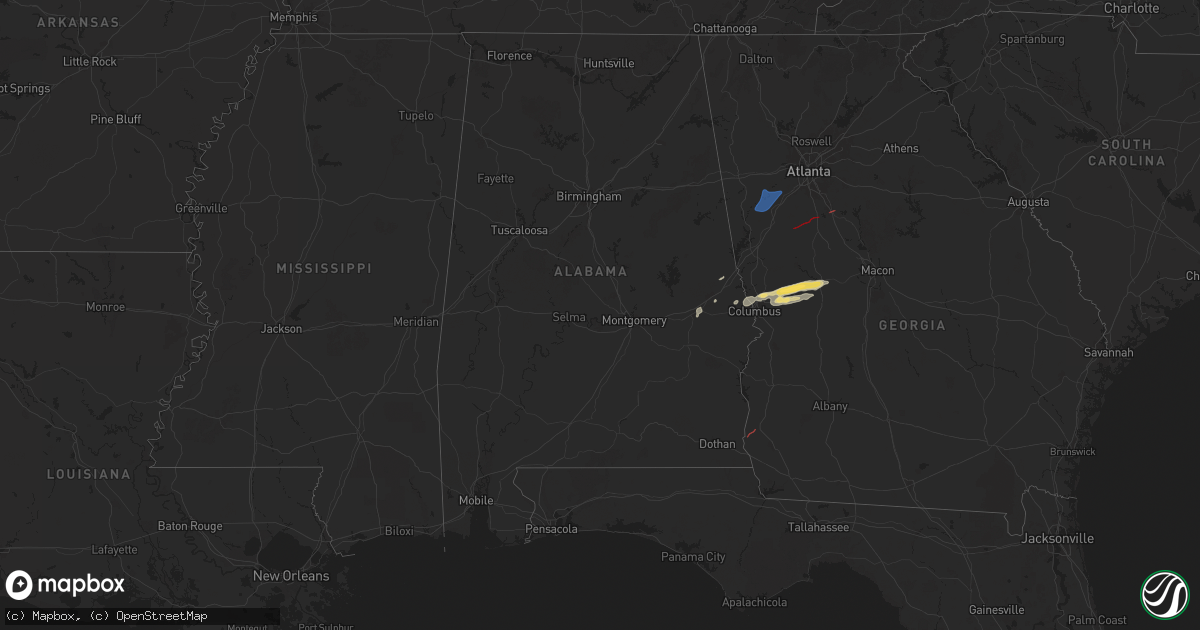
Hail Map in Alabama on April 6, 2025
Get this storm
April 6 map
$229
one time, instant access
Download today. No call, no setup
Keep the $229
Bought the map and want the full workflow? Apply the entire $229 to a subscription within 7 days. None of it is wasted.
Every map, not just this one
This buys you this map. Subscription and you get every map we run, in the markets you choose from a few cities to whole states to nationwide. Plus real-time alerts the moment a storm fires.
Contact data
Name, contact info, occupancy, even credit band for addresses in the footprint. You go from where it hit to who to call.
Become the source they trust
Unlimited branding weather history reports on demand. You already have the documented answer ready for the property owner, and you are the one who showed up with it.
Property data and RoofTrace estimates
Pull up any address you have got, its value and the exact code rules for that jurisdiction, straight from One Click Code. Then RoofTrace estimates the squares, pitch, and roof value, priced the way you price.
Storm reports in Alabama
Alabama
| Date | Description |
|---|---|
| 04/06/202512:46 PM CDT | Trees down on highway 280 and lee road 93 in waverly. |
| 04/06/202511:46 AM CDT | A storage building was blown apart. |
| 04/06/202511:00 AM CDT | A few trees were downed in the southern part of randolph county. |
| 04/06/202511:00 AM CDT | Corrects previous tstm wnd dmg report from roanoke for new info. A few trees were downed at various locations across the southern part of randolph county. Highway 22 wa |
| 04/06/202510:54 AM CDT | Trees down and blocking both lanes of county road 92. |
| 04/06/202510:14 AM CDT | Trees down along cr 405. A possible tds was observed in this area. |
| 04/06/202510:13 AM CDT | An ef-1 tornado was confirmed by nws meteorologists... Affecting the area near sixmile creek east of sardis. |
| 04/06/202510:07 AM CDT | Trees down and blocking county road 457. |
| 04/06/20259:00 AM CDT | Roof damage to restaurant... Along with trees and power lines down. |
| 04/05/202510:21 PM CDT | An ef-0 tornado was confirmed in the star hill rd area of barbour county. Max winds 60 mph. Path length 0.48 miles. |
Cities Impacted by Hail Map on April 6, 2025
- Thomasville, AL
- Newnan, GA
- Whitesburg, GA
- Palmetto, GA
- Winston, GA
- Fairburn, GA
- Tuskegee, AL
- Auburn, AL
- Opelika, AL
- Phenix City, AL
- Smiths Station, AL
- Salem, AL
- Columbus, GA
- Fortson, GA
- Midland, GA
- Cataula, GA
- Waverly Hall, GA
- Ellerslie, GA
- Upatoi, GA
- Box Springs, GA
- Talbotton, GA
- Fort Benning, GA
- Junction City, GA
- Butler, GA
- Culloden, GA
- Roberta, GA
- Valley, AL
- Cusseta, AL
- Lafayette, AL
- Blakely, GA
- Senoia, GA
- Brooks, GA
- Griffin, GA
- Locust Grove, GA
- Mcdonough, GA


