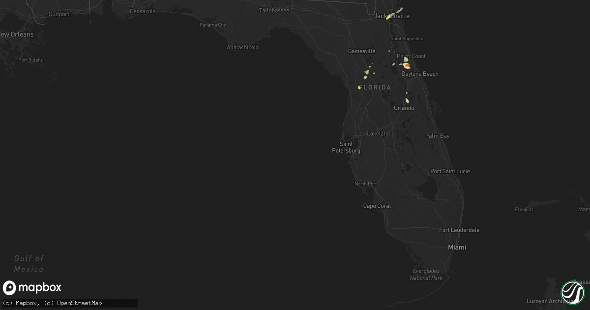
Hail Map in Florida on April 6, 2019
Get this storm
April 6 map
$229
one time, instant access
Download today. No call, no setup
Keep the $229
Bought the map and want the full workflow? Apply the entire $229 to a subscription within 7 days. None of it is wasted.
Every map, not just this one
This buys you this map. Subscription and you get every map we run, in the markets you choose from a few cities to whole states to nationwide. Plus real-time alerts the moment a storm fires.
Contact data
Name, contact info, occupancy, even credit band for addresses in the footprint. You go from where it hit to who to call.
Become the source they trust
Unlimited branding weather history reports on demand. You already have the documented answer ready for the property owner, and you are the one who showed up with it.
Property data and RoofTrace estimates
Pull up any address you have got, its value and the exact code rules for that jurisdiction, straight from One Click Code. Then RoofTrace estimates the squares, pitch, and roof value, priced the way you price.
Storm reports in Florida
Florida
| Date | Description |
|---|---|
| 04/06/20196:21 PM CDT | Social media photo shows hail estimated to be around one inch in size. Time of event estimated by radar. |
| 04/06/20194:39 PM CDT | Emergency manager reported golf ball size hail observed in codys corner southwest of bunnell. |
| 04/06/20193:37 PM CDT | Storm spotter observed quarter inch hail at 1900 nw 58th court. |
| 04/06/20193:35 PM CDT | Marion county public safety reported minor damage to single engine... Fixed wing aircrafts due to high winds at ocala airport. |
| 04/06/20193:52 AM CDT | At 852 PM EDT, a severe thunderstorm was located near Osteen, or near Deltona, moving southeast at 15 mph. HAZARD...60 mph wind gusts and quarter size hail. SOURCE...Radar indicated. IMPACT...Hail damage to vehicles is expected. Expect wind damage to roofs, siding, and trees. Locations impacted include... Deltona, Sanford, Altamonte Springs, Oviedo and Winter Springs. |
| 04/06/20193:09 AM CDT | At 809 PM EDT, a severe thunderstorm was located over DeBary, moving southeast at 10 mph. HAZARD...60 mph wind gusts and nickel size hail. SOURCE...Radar indicated. IMPACT...Expect damage to roofs, siding, and trees. Locations impacted include... Deltona, Sanford, Winter Springs, Lake Mary and Orange City. |
| 04/06/20192:36 AM CDT | At 735 PM EDT, a severe thunderstorm was located over Jacksonville, moving northeast at 15 mph. HAZARD...60 mph wind gusts and quarter size hail. SOURCE...Radar indicated. IMPACT...Hail damage to vehicles is expected. Expect wind damage to roofs, siding, and trees. Locations impacted include... Jacksonville, Arlington, Ortega, Oceanway, Craig Field, Little Talbot Island, Fort Caroline, Riverside, San Marco and Tallyrand. |
| 04/06/201912:30 AM CDT | At 530 PM EDT, severe thunderstorms were located along a line extending from Bunnell to 12 miles southwest of Flagler Beach, moving east at 10 mph. HAZARD...60 mph wind gusts and quarter size hail. SOURCE...Radar indicated. IMPACT...Hail damage to vehicles is expected. Expect wind damage to roofs, siding, and trees. Locations impacted include... Flagler Beach, Bunnell and Beverly Beach. |
| 04/05/201911:22 PM CDT | At 422 PM EDT, a severe thunderstorm was located over Ocala Airport, or 7 miles west of Ocala, moving northeast at 15 mph. HAZARD...60 mph wind gusts and quarter size hail. SOURCE...Radar indicated. IMPACT...Hail damage to vehicles is expected. Expect wind damage to roofs, siding, and trees. Locations impacted include... Ocala, Ocala Airport, Anthony and Lowell. |
All States Impacted by Hail Map on April 6, 2019
Cities Impacted by Hail Map on April 6, 2019
- Edwards, MS
- Alma, GA
- Hearne, TX
- Calvert, TX
- Livingston, TX
- Cibolo, TX
- Schertz, TX
- Buffalo, TX
- Elkhart, TX
- Palestine, TX
- Repton, AL
- Monroeville, AL
- Frisco City, AL
- Sandia, TX
- Orange Grove, TX
- George West, TX
- Belzoni, MS
- Silver City, MS
- Caldwell, TX
- Somerville, TX
- Bentley, LA
- Pollock, LA
- Jourdanton, TX
- Eagle Pass, TX
- Selma, AL
- Greensboro, AL
- Gallion, AL
- Faunsdale, AL
- Zavalla, TX
- Newcastle, TX
- Olney, TX
- Philadelphia, MS
- Homer, LA
- Haynesville, LA
- Vicksburg, MS
- Bluff Dale, TX
- Kenedy, TX
- Three Rivers, TX
- Casselberry, FL
- Winter Springs, FL
- Anderson, TX
- Red Rock, TX
- Bastrop, TX
- Dale, TX
- Lockhart, TX
- Haleyville, AL
- Brilliant, AL
- Winfield, AL
- Alto, TX
- Montgomery, LA
- Jacksonville, FL
- Lone Star, TX
- Monterey, LA
- Jonesville, LA
- Jena, LA
- Pineville, LA
- Columbia, LA
- Minden, LA
- Georgetown, FL
- Frierson, LA
- Hebbronville, TX
- San Marcos, TX
- Yorktown, TX
- Runge, TX
- Nordheim, TX
- Ore City, TX
- Gilmer, TX
- Fort Worth, TX
- New Waverly, TX
- Morton, MS
- Brandon, MS
- Pelahatchie, MS
- Marquez, TX
- Atlanta, LA
- Natchitoches, LA
- Meigs, GA
- Pelham, GA
- Hermitage, AR
- Madisonville, TX
- Normangee, TX
- Elgin, TX
- Kyle, TX
- New Braunfels, TX
- Cedar Creek, TX
- Wimberley, TX
- Maxwell, TX
- Smithville, TX
- Rosanky, TX
- Martindale, TX
- Giddings, TX
- Paige, TX
- Canyon Lake, TX
- McDade, TX
- Del Valle, TX
- Longwood, FL
- Stephenville, TX
- Gurdon, AR
- Okolona, AR
- Arkadelphia, AR
- Austin, TX
- San Augustine, TX
- Riverton, NE
- Smith Center, KS
- Cameron, TX
- Burlington, TX
- Brunswick, GA
- Anacoco, LA
- Leesville, LA
- Hornbeck, LA
- Falls City, TX
- Holdrege, NE
- Grapeland, TX
- Otis, LA
- Sieper, LA
- Hineston, LA
- Boyce, LA
- Elmer, LA
- Colmesneil, TX
- Woodville, TX
- Rohwer, AR
- Dermott, AR
- Lake Village, AR
- Arkansas City, AR
- McGehee, AR
- North Zulch, TX
- Bryan, TX
- Chester, TX
- Jacksboro, TX
- Baskin, LA
- Rayville, LA
- Mangham, LA
- Waynesville, GA
- Gonzales, TX
- Waelder, TX
- Franklin, NE
- Bloomington, NE
- Republican City, NE
- Naponee, NE
- Choudrant, LA
- Ruston, LA
- Colfax, LA
- Hamburg, AR
- Montrose, AR
- Hemphill, TX
- Brenham, TX
- Sioux City, IA
- Hinton, IA
- Calliham, TX
- Tilden, TX
- Delhi, LA
- Tallulah, LA
- Crystal City, TX
- Shreveport, LA
- Elm Grove, LA
- Round Mountain, TX
- Rusk, TX
- Jacksonville, TX
- West, MS
- Gladewater, TX
- Kilgore, TX
- Many, LA
- Pineland, TX
- Brookeland, TX
- Broaddus, TX
- Jasper, TX
- Bronson, TX
- Saint Marys, GA
- Waverly, GA
- Farmerville, LA
- Spearsville, LA
- Alice, TX
- San Diego, TX
- Nicholls, GA
- Wilcox, NE
- Alma, NE
- Wilmar, AR
- Jersey, AR
- Strong, AR
- Cotulla, TX
- Fowlerton, TX
- Hampton, AR
- Chireno, TX
- Etoile, TX
- Winnfield, LA
- Midway, TX
- Dry Prong, LA
- El Dorado, AR
- Pitkin, LA
- Loomis, NE
- Atlanta, GA
- Franklin, TX
- Goldonna, LA
- Natchez, LA
- Robeline, LA
- Melrose, LA
- Dubach, LA
- Lena, MS
- Forest, MS
- Carbon, TX
- Opp, AL
- Andalusia, AL
- Taylor, TX
- Coupland, TX
- Diana, TX
- Rio Grande City, TX
- Roma, TX
- Guerra, TX
- Wood River, NE
- Avinger, TX
- Harwood, TX
- Luling, TX
- Buckholts, TX
- Floresville, TX
- Woodland, AL
- Roanoke, AL
- Richards, TX
- Huntsville, TX
- Nashville, AR
- Ball, LA
- Whitsett, TX
- Sibley, LA
- Dubberly, LA
- Doyline, LA
- Arlington, GA
- Leary, GA
- Princeton, LA
- Zapata, TX
- Monticello, AR
- Sarepta, LA
- Cotton Valley, LA
- Kennard, TX
- Lott, TX
- Centerville, TX
- Boerne, TX
- Troup, TX
- Shelton, NE
- Gibbon, NE
- Ravenna, NE
- Camilla, GA
- Sale City, GA
- Ocala, FL
- Sallis, MS
- Liberty Hill, TX
- Oakwood, TX
- Tullos, LA
- Georgetown, LA
- Rockdale, TX
- Durant, MS
- Lexington, MS
- Milano, TX
- Thrall, TX
- Thorndale, TX
- Gause, TX
- Douglass, TX
- Jewett, TX
- Cushing, TX
- Bremond, TX
- Crockett, TX
- Thornton, TX
- Rosebud, TX
- Haughton, LA
- Barksdale Afb, LA
- Mansfield, LA
- Slagle, LA
- Mora, LA
- Provencal, LA
- Fort Polk, LA
- Simpson, LA
- Lena, LA
- New Llano, LA
- Cloutierville, LA
- Blanco, TX
- Greenville, MS
- Leland, MS
- Washington, TX
- Tekamah, NE
- Arcadia, LA
- Bernice, LA
- Tolar, TX
- Hernando, FL
- Gatesville, TX
- West Green, GA
- Walnut Grove, MS
- Heflin, LA
- Virgil, KS
- Madison, KS
- Groveton, TX
- Citra, FL
- Athens, LA
- Gibsland, LA
- Lisbon, LA
- Northport, AL
- Buhl, AL
- Coker, AL
- Seguin, TX
- Axtell, NE
- Sikes, LA
- Blakely, GA
- Indianola, MS
- Lindale, TX
- Georgiana, AL
- Bunnell, FL
- Omaha, GA
- Sabinal, TX
- Utopia, TX
- Laredo, TX
- Kensington, KS
- Hamilton, AL
- Bear Creek, AL
- Hackleburg, AL
- Trinity, TX
- Winona, TX
- Sylvester, GA
- Albany, GA
- Johnson City, TX
- Dallas, TX
- Hartsfield, GA
- Temple, TX
- Pleasanton, TX
- Encinal, TX
- Poteet, TX
- Charlotte, TX
- Debary, FL
- Sanford, FL
- Ferriday, LA
- Bankston, AL
- Fayette, AL
- Berry, AL
- Junction City, AR
- Hondo, TX
- D Hanis, TX
- Beeville, TX
- Merrill, IA
- North Sioux City, SD
- Pearl, MS
- Granger, TX
- Georgetown, TX
- Doddridge, AR
- Ida, LA
- Jefferson, TX
- Sherrill, AR
- De Soto, GA
- Leslie, GA
- Sutherland Springs, TX
- La Vernia, TX
- Chappell Hill, TX
- Marion, LA
- Cuthbert, GA
- Damascus, GA
- Red Level, AL
- Lovelady, TX
- Leona, TX
- Quinlan, TX
- Jarrell, TX
- Florence, TX
- Louise, MS
- Lynn, AL
- Richland, MS
- Byram, MS
- Terry, MS
- Florien, LA
- Nixon, TX
- Hesston, KS
- Quemado, TX
- Summerfield, LA
- Lillie, LA
- Deville, LA
- Kosse, TX
- Reagan, TX
- Isola, MS
- Altheimer, AR
- Pine Bluff, AR
- White Hall, AR
- Utica, MS
- Silver Springs, FL
- Eldridge, AL
- Carbon Hill, AL
- Bastrop, LA
- Batesville, TX
- Benoit, MS
- Douglas, GA
- Bedias, TX
- Kingsbury, TX
- Eutaw, AL
- Lampasas, TX
- Campbellton, TX
- Emerson, AR
- Harleton, TX
- San Antonio, TX
- Adkins, TX
- Granbury, TX
- Breckenridge, TX
- Uniontown, AL
- Moulton, AL
- Bainbridge, GA
- De Kalb, MS
- Colquitt, GA
- La Pryor, TX
- Canton, KS
- Newton, KS
- Moundridge, KS
- Halstead, KS
- Pittsburg, TX
- Daingerfield, TX
- Hughes Springs, TX
- Navasota, TX
- San Saba, TX
- Humnoke, AR
- Wabbaseka, AR
- Bentonia, MS
- Grapevine, AR
- Groesbeck, TX
- Huntington, TX
- Linden, TX
- Waterproof, LA
- Lorman, MS
- Nauvoo, AL
- Cobb, GA
- Leesburg, GA
- Bertram, TX
- Converse, TX
- Atlanta, NE
- Lincoln, AL
- Talladega, AL
- Bonita, LA
- Mer Rouge, LA
- Onalaska, TX
- Shepherd, TX
- Columbus, TX
- Holland, TX
- Bullard, TX
- Salado, TX
- Eureka, KS
- Lexington, TX
- Carrizo Springs, TX
- Grayson, LA
- Olla, LA
- Kelly, LA
- Stockdale, TX
- Manor, TX
- Morgan, GA
- Quitman, LA
- Jonesboro, LA
- Emelle, AL
- Trout, LA
- Graford, TX
- Carthage, MS
- Sardis, AL
- Lyons, TX
- Ledbetter, TX
- Morris, GA
- Coolidge, GA
- Ochlocknee, GA
- Moultrie, GA
- Funk, NE
- Scooba, MS
- Preston, MS
- Crescent City, FL
- Jackson, MS
- Plain Dealing, LA
- Springhill, LA
- Ringgold, LA
- Chatham, LA
- Hutto, TX
- Davilla, TX
- Pflugerville, TX
- Rogers, TX
- Yazoo City, MS
- Bolton, MS
- Hillsboro, TX
- Louisville, MS
- Fort Gaines, GA
- Abbeville, AL
- Louin, MS
- Clayton, LA
- Rison, AR
- Edison, GA
- Coleman, GA
- Wedowee, AL
- Cleveland, MS
- Beulah, MS
- Epps, LA
- Joshua, TX
- Deridder, LA
- Uvalde, TX
- Sawyerville, AL
- Cherokee, TX
- Jemison, AL
- Calera, AL
- Montevallo, AL
- White Oak, TX
- Longview, TX
- Stuttgart, AR
- Lake, MS
- Carthage, AR
- Doddsville, MS
- Shaw, MS
- Palatka, FL
- College Station, TX
- Mineola, TX
- Center Point, TX
- Harrisonburg, LA
- Sicily Island, LA
- Elmendorf, TX
- Guin, AL
- Saint Joseph, LA
- Cleveland, TX
- Elrod, AL
- Echola, AL
- Union, MS
- Bellville, TX
- Downsville, LA
- Braxton, MS
- Grand Cane, LA
- New Ulm, TX
- Medina, TX
- Maplesville, AL
- Plantersville, AL
- Stanton, AL
- Winter Park, FL
- Townley, AL
- Doerun, GA
- Belton, TX
- Fountain Hill, AR
- Hye, TX
- Big Sandy, TX
- Marlin, TX
- Salem, SD
- Kosciusko, MS
- Riesel, TX
- Leander, TX
- Spring Branch, TX
- Driftwood, TX
- Dripping Springs, TX
- Shongaloo, LA
- May, TX
- Rising Star, TX
- Comanche, TX
- Dublin, TX
- Tyler, TX
- Buda, TX
- Hildreth, NE
- Alexandria, LA
- Lecompte, LA
- Center Point, LA


