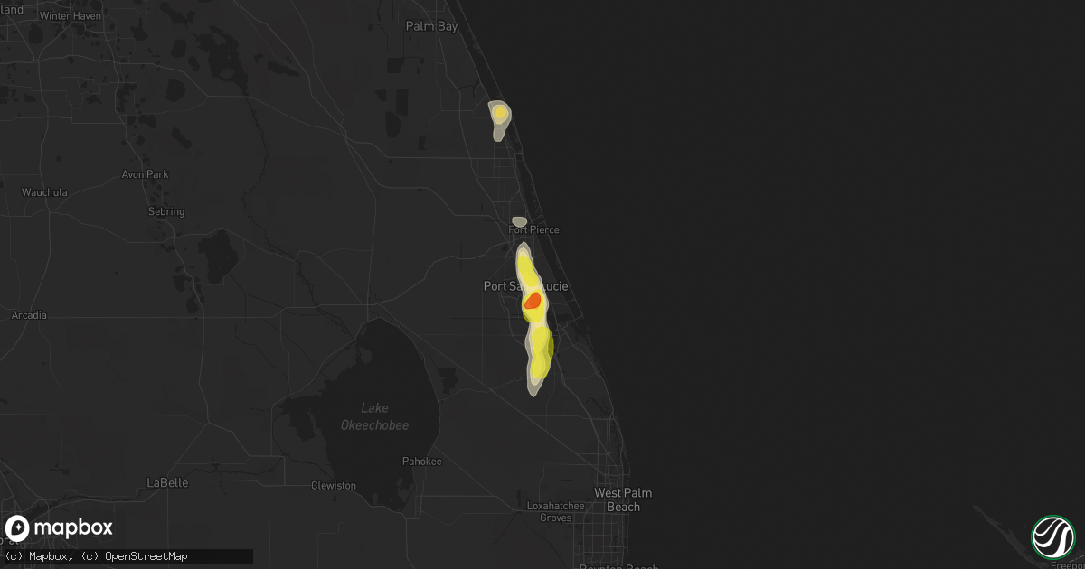
Hail Map in Port Saint Lucie, FL on April 5, 2019
Get this storm
April 5 map
$229
one time, instant access
Download today. No call, no setup
Keep the $229
Bought the map and want the full workflow? Apply the entire $229 to a subscription within 7 days. None of it is wasted.
Every map, not just this one
This buys you this map. Subscription and you get every map we run, in the markets you choose from a few cities to whole states to nationwide. Plus real-time alerts the moment a storm fires.
Contact data
Name, contact info, occupancy, even credit band for addresses in the footprint. You go from where it hit to who to call.
Become the source they trust
Unlimited branding weather history reports on demand. You already have the documented answer ready for the property owner, and you are the one who showed up with it.
Property data and RoofTrace estimates
Pull up any address you have got, its value and the exact code rules for that jurisdiction, straight from One Click Code. Then RoofTrace estimates the squares, pitch, and roof value, priced the way you price.
Storm reports in Port Saint Lucie, FL
Port Saint Lucie, FL
| Date | Description |
|---|---|
| 04/05/20194:05 PM CDT | Broadcast media relays photo via social media of hailstones ranging in size from half dollar to nickel taken in the sandpiper bay community. Time estimated from radar. |
| 04/05/20193:54 PM CDT | Local broadcast media shares photo via social media of approximately golf ball sized hailstone... Taken near the intersection of se westmoreland blvd and port st lucie |
All States Impacted by Hail Map on April 5, 2019
All Cities Impacted by Hail Map on April 5, 2019
- Butte, NE
- Fairfax, SD
- Seminole, TX
- Lamesa, TX
- Ozona, TX
- McCamey, TX
- Gardendale, TX
- Amarillo, TX
- Colorado City, TX
- Sonora, TX
- Fort Pierce, FL
- Stanton, TX
- Masterson, TX
- Big Lake, TX
- Slaton, TX
- Post, TX
- Mission, SD
- Platte, SD
- Kimball, SD
- Crane, TX
- Saint Francis, SD
- Palm City, FL
- Port Saint Lucie, FL
- Old Glory, TX
- Aspermont, TX
- Paducah, TX
- Snyder, TX
- Jayton, TX
- Goldsmith, TX
- Odessa, TX
- Kermit, TX
- Justiceburg, TX
- Big Spring, TX
- Loxahatchee, FL
- Andrews, TX
- Wingate, TX
- Norton, TX
- Winters, TX
- Tahoka, TX
- Wolfforth, TX
- Lubbock, TX
- Wilson, TX
- Imperial, TX
- Fort Stockton, TX
- Midkiff, TX
- Dryden, TX
- Stuart, FL
- Chunchula, AL
- Burke, SD
- Happy, TX
- Canyon, TX
- Kress, TX
- Tulia, TX
- Littlefield, TX
- Plainview, TX
- Claude, TX
- Tuscola, TX
- Sebastian, FL
- Vero Beach, FL
- Colome, SD
- Winner, SD
- Odonnell, TX
- Ackerly, TX
- Tarzan, TX
- Lenorah, TX
- Miles, TX
- Girard, TX
- Dickens, TX
- Fluvanna, TX
- Gail, TX
- Moran, TX
- Knott, TX
- Atkinson, NE
- Coahoma, TX
- Vancourt, TX
- Wall, TX
- Ovalo, TX
- Seagraves, TX
- Ballinger, TX
- Sterling City, TX
- Canton, SD
- Westbrook, TX
- Valentine, NE
- San Angelo, TX
- Blackwell, TX
- Bronte, TX
- Abilene, TX
- Panhandle, TX
- Indiantown, FL
- Jensen Beach, FL
- Garden City, TX
- Silverton, TX
- Lake Andes, SD
- Geddes, SD
- Gregory, SD
- Welch, TX
- Spur, TX
- Midland, TX


