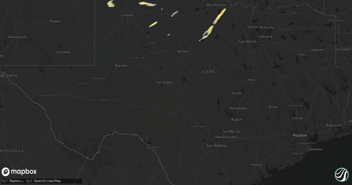
Hail Map in Texas on April 3, 2026
Get this storm
April 3 map
$229
one time, instant access
Download today. No call, no setup
Keep the $229
Bought the map and want the full workflow? Apply the entire $229 to a subscription within 7 days. None of it is wasted.
Every map, not just this one
This buys you this map. Subscription and you get every map we run, in the markets you choose from a few cities to whole states to nationwide. Plus real-time alerts the moment a storm fires.
Contact data
Name, contact info, occupancy, even credit band for addresses in the footprint. You go from where it hit to who to call.
Become the source they trust
Unlimited branding weather history reports on demand. You already have the documented answer ready for the property owner, and you are the one who showed up with it.
Property data and RoofTrace estimates
Pull up any address you have got, its value and the exact code rules for that jurisdiction, straight from One Click Code. Then RoofTrace estimates the squares, pitch, and roof value, priced the way you price.
Storm reports in Texas
Texas
| Date | Description |
|---|---|
| 04/03/20263:15 AM CDT | A few trees...power lines...and power poles blown down in nocona. |
| 04/03/20262:26 AM CDT | A local report indicates 58 MPH wind near 1 NNE Sheppard Afb |
| 04/02/202611:50 PM CDT | 30x30 metal carport blown into the street by the county hospital. |
| 04/02/202611:50 PM CDT | Corrects previous tstm wnd dmg report from quanah. Shared images of a center irrigation pivot overturned and 30x30 metal carport blown into the street in quanah. |
| 04/02/202611:40 PM CDT | A local report indicates 86 MPH wind near 3 WNW Goodlett |
| 04/02/202611:25 PM CDT | Portions of roof blown off a gas station in plainview. Time estimated from radar. |
| 04/02/202611:10 PM CDT | A local report indicates 1.00 inch wind near 7 NW Childress |
| 04/02/202611:00 PM CDT | Photo shows several hailstones a bit bigger than quarter size. Location estimated from radar. |
| 04/02/202610:55 PM CDT | Plenty of hail with stones up to about quarter size. Time estimated from radar. |
| 04/02/202610:54 PM CDT | Severe gust associated with outflow from approaching storm. Additional gust to 59 mph measured at 1056 pm. |
All States Impacted by Hail Map on April 3, 2026
Cities Impacted by Hail Map on April 3, 2026
- Dawson, NE
- Humboldt, NE
- Du Bois, NE
- Stella, NE
- Verdon, NE
- Moultrie, GA
- Pavo, GA
- Wichita, KS
- Clearwater, KS
- Auburn, NE
- Chillicothe, TX
- Vernon, TX
- Shubert, NE
- Nemaha, NE
- Old Town, FL
- Trenton, FL
- Haysville, KS
- Mcconnell Afb, KS
- Derby, KS
- Wellington, KS
- Florence, KS
- Peck, KS
- Rock Port, MO
- Andover, KS
- Cedar Point, KS
- Belle Plaine, KS
- Pond Creek, OK
- Peru, NE
- Fairfax, MO
- Tarkio, MO
- Falls City, NE
- Enid, OK
- Augusta, KS
- Gotebo, OK
- Mountain View, OK
- Elmdale, KS
- Sidney, IA
- Madison, FL
- Plattsmouth, NE
- Kremlin, OK
- Medford, OK
- Cottonwood Falls, KS
- Franklin, IN
- Tipton, OK
- Elmer, OK
- El Dorado, KS
- Towanda, KS
- Logan, IA
- Douglass, KS
- Udall, KS
- Mulvane, KS
- Hunter, OK
- Nardin, OK
- Braman, OK
- Lamont, OK
- Carnegie, OK
- Cordell, OK
- Westboro, MO
- Frederick, OK
- Geary, OK
- Hydro, OK
- Fairmont, OK
- Waukomis, OK
- Burlington Junction, MO
- Elmo, MO
- Clearmont, MO
- Greenfield, OK
- Watonga, OK
- Garber, OK
- Leon, KS
- Douglas, OK
- Campbellton, FL
- Graceville, FL
- Inglis, FL
- Roosevelt, OK
- Loyal, OK
- Omega, OK
- Kingfisher, OK
- Hobart, OK
- Winfield, KS
- Atlanta, KS
- Snyder, OK
- Billings, OK
- Hennessey, OK
- Fort Cobb, OK
- Hopkins, MO
- Braddyville, IA
- Bedford, IA
- Okarche, OK
- Covington, OK
- Snyder, TX
- Arkansas City, KS
- Newkirk, OK
- Yankeetown, FL
- Rock, KS
- Cottonwood, AL
- Slocomb, AL
- Latham, KS
- Fowler, IN
- Justiceburg, TX
- Girard, TX
- Topeka, IL
- Havana, IL
- Gracemont, OK
- Forest City, IL
- Manito, IL
- Perry, OK
- Easton, IL
- Mount Gilead, OH
- Bellville, OH
- Calumet, OK
- Piedmont, KS
- Red Rock, OK
- Maple City, KS
- Blockton, IA
- Sheridan, MO
- Perrysville, OH
- Otterbein, IN
- Paducah, TX
- Corning, IA
- Gravity, IA
- Cambridge, KS
- Burden, KS
- Green Valley, IL
- West Lafayette, IN
- Versailles, IL
- Grenola, KS
- Dexter, KS
- Danville, IL
- Eureka, KS
- San Jose, IL
- New Market, IA
- Clearfield, IA
- Benton, IA
- Crystal River, FL
- Cedar Vale, KS
- Morrison, OK
- Howard, KS
- Delavan, IL
- Tremont, IL
- Lafayette, IN
- Diagonal, IA
- Pekin, IL
- South Pekin, IL
- Severy, KS
- Lewistown, IL
- Toronto, KS
- Neal, KS
- Newton, GA
- Hopedale, IL
- Fall River, KS
- Pawnee, OK
- Ralston, OK
- Virgil, KS
- Rocky, OK
- Cissna Park, IL
- Rankin, IL
- Sedan, KS
- Lone Wolf, OK
- Galveston, IN
- Mackinaw, IL
- Fairfax, OK
- Edison, OH
- Cardington, OH
- Milford, IL
- Hoopeston, IL
- Bath, IL
- Sparkman, AR
- Rushville, MO
- De Kalb, MO
- Peoria, IL
- Mapleton, IL
- Glasford, IL
- Canton, IL
- Camden, AR
- Stillwater, OK
- Astoria, IL
- Mount Ayr, IA
- Ellston, IA
- Tingley, IA
- Mangum, OK
- Killbuck, OH
- Millersburg, OH
- Stanford, IL
- Danvers, IL
- Minier, IL
- Bearden, AR
- Colony, OK
- Longton, KS
- Altus, OK
- Olustee, OK
- Gould, OK
- Mason City, IL
- Fredonia, KS
- Elk City, KS
- Altus Afb, OK
- Hinton, OK
- Carlock, IL
- Blair, OK
- Morton, IL
- Peru, KS
- Butler, OH
- Fredericktown, OH
- Binger, OK
- Headrick, OK
- Eldorado, OK
- Deer Creek, IL
- Benedict, KS
- Havana, KS
- Lookeba, OK
- Claremore, OK
- El Paso, IL
- Congerville, IL
- Independence, KS
- Breckenridge, TX
- Liverpool, IL
- Duke, OK
- Chelsea, OK
- Glenmont, OH
- Graham, TX
- South Bend, TX
- Woodson, TX
- Union City, OK
- El Reno, OK
- Anadarko, OK
- Minco, OK
- Rushsylvania, OH
- La Rue, OH
- New Bloomington, OH
- Marion, OH
- Prospect, OH
- Goodfield, IL
- Apache, OK
- Ramona, OK
- Ochelata, OK
- Bartlesville, OK
- Green Camp, OH
- Newcastle, TX
- Warsaw, OH
- Caledonia, OH
- Galesburg, KS
- Parsons, KS
- Brinkhaven, OH
- Blissfield, OH
- Baltic, OH
- Coshocton, OH
- Dennis, KS
- Cherryvale, KS
- Adair, OK
- Big Cabin, OK
- Vinita, OK
- Nowata, OK
- Fresno, OH
- Olney, TX
- Dover, OK
- Tuttle, OK
- Yukon, OK
- East Peoria, IL
- Groveland, IL
- Mustang, OK
- Loving, TX
- Decatur, IN
- Windthorst, TX
- Oklahoma City, OK
- Wheatland, OK
- Fairland, OK
- Henrietta, TX
- Afton, OK
- Hoagland, IN
- Monroeville, IN
- Jacksboro, TX
- Delaware, OK
- Bethany, OK
- Marshall, OK
- Newalla, OK
- Choctaw, OK
- Norman, OK
- Lucien, OK
- Guthrie, OK
- Hudson, IL
- Mcloud, OK
- Shawnee, OK
- Tecumseh, OK
- Spencerville, OH
- Venedocia, OH
- Delphos, OH
- Blanchard, OK
- Wyandotte, OK
- Macomb, OK
- Welch, OK
- Bluejacket, OK
- Talala, OK
- Mountain Park, OK
- Lima, OH
- Prague, OK
- Meeker, OK
- Asher, OK
- Earlsboro, OK
- Maud, OK
- Seminole, OK
- Okemah, OK
- Amherst, TX
- Quitaque, TX
- Tulia, TX
- Wewoka, OK
- Bowlegs, OK
- Konawa, OK
- Paden, OK
- Wetumka, OK
- Fieldton, TX
- Earth, TX
- Kress, TX
- Ridgeway, OH
- Albany, TX
- Lafayette, OH
- Harrod, OH
- Ada, OH
- Olton, TX
- Plainview, TX
- Holdenville, OK
- Littlefield, TX
- Ada, OK
- Roff, OK
- Alger, OH
- Bluffton, OH
- Miami, OK
- Weleetka, OK
- Dustin, OK
- Dola, OH
- Kenton, OH
- Henryetta, OK
- Quapaw, OK
- Eufaula, OK
- Hanna, OK
- Joplin, MO
- Neosho, MO
- Childress, TX
- Baxter Springs, KS
- Galena, KS
- Seneca, MO
- Quanah, TX
- Wayne, OK
- Lexington, OK
- Diamond, MO
- Granby, MO
- Turkey, TX
- Aspermont, TX
- Pierce City, MO
- Hale Center, TX
- Floydada, TX
- Matador, TX
- Sallisaw, OK
- Gans, OK
- Muldrow, OK
- Roland, OK
- Lake Geneva, WI
- Roaring Springs, TX
- Burlington, WI
- Van Buren, AR
- Fort Smith, AR
- Kilbourne, IL
- Browning, IL
- Lockney, TX


