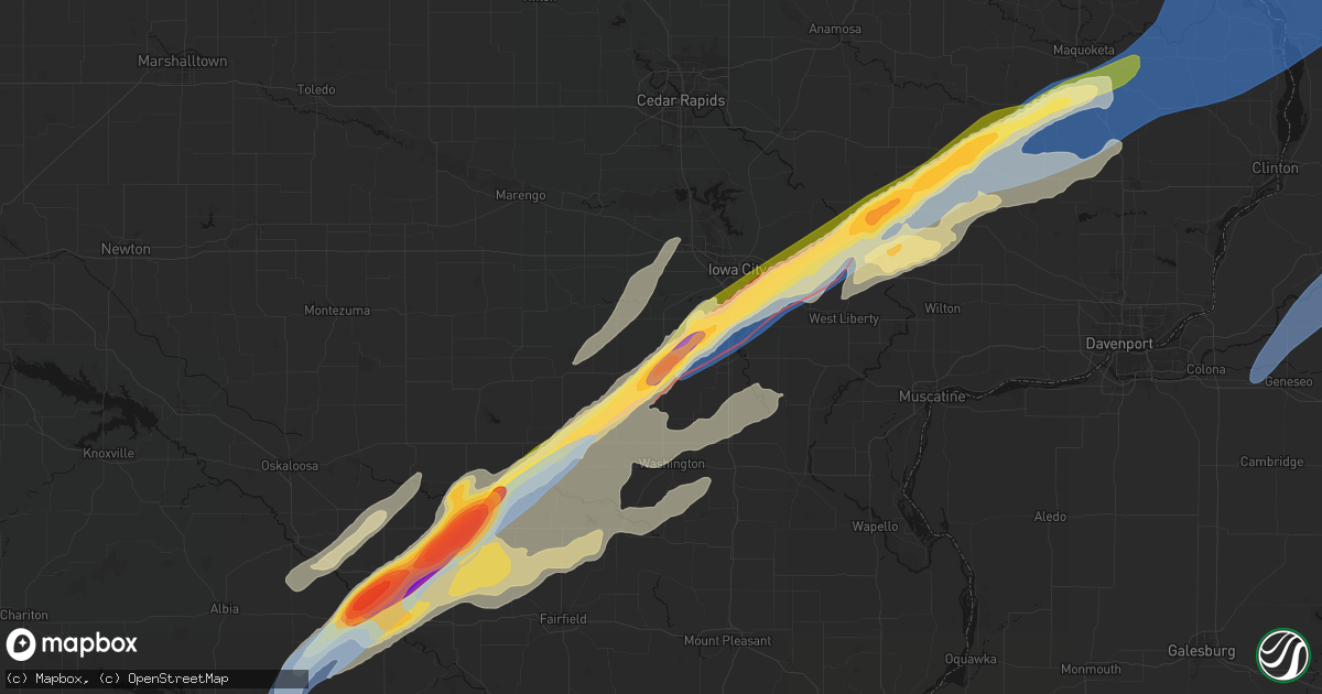
Hail Map in Kalona, IA on April 2, 2026
Get this storm
April 2 map
$229
one time, instant access
Download today. No call, no setup
Keep the $229
Bought the map and want the full workflow? Apply the entire $229 to a subscription within 7 days. None of it is wasted.
Every map, not just this one
This buys you this map. Subscription and you get every map we run, in the markets you choose from a few cities to whole states to nationwide. Plus real-time alerts the moment a storm fires.
Contact data
Name, contact info, occupancy, even credit band for addresses in the footprint. You go from where it hit to who to call.
Become the source they trust
Unlimited branding weather history reports on demand. You already have the documented answer ready for the property owner, and you are the one who showed up with it.
Property data and RoofTrace estimates
Pull up any address you have got, its value and the exact code rules for that jurisdiction, straight from One Click Code. Then RoofTrace estimates the squares, pitch, and roof value, priced the way you price.
Storm reports in Kalona, IA
Kalona, IA
| Date | Description |
|---|---|
| 04/02/20264:13 PM CDT | A local report indicates 1.75 inch wind near 1 W Kalona |
All States Impacted by Hail Map on April 2, 2026
All Cities Impacted by Hail Map on April 2, 2026
- Syracuse, UT
- Layton, UT
- Clearfield, UT
- Hooper, UT
- Ogden, UT
- Roy, UT
- Hill Afb, UT
- Eden, UT
- Huntsville, UT
- Morgan, UT
- Cainsville, MO
- Blythedale, MO
- Davis City, IA
- Lineville, IA
- Leon, IA
- Allerton, IA
- Clio, IA
- Corydon, IA
- Princeton, MO
- Mercer, MO
- Zachary, LA
- Pride, LA
- Blakesburg, IA
- Ottumwa, IA
- Powersville, MO
- Albia, IA
- Melrose, IA
- Unionville, IA
- Lovilia, IA
- Hedrick, IA
- Lucerne, MO
- Fort Myers, FL
- Martinsburg, IA
- Packwood, IA
- Ollie, IA
- Sigourney, IA
- Keota, IA
- Harper, IA
- Eddyville, IA
- West Chester, IA
- Wellman, IA
- Washington, IA
- Drakesville, IA
- Cape Coral, FL
- Kirkville, IA
- Fremont, IA
- Cedar, IA
- Kalona, IA
- Williamsburg, IA
- Deep River, IA
- North English, IA
- Ladora, IA
- Millersburg, IA
- Marengo, IA
- Conroy, IA
- South Amana, IA
- Homestead, IA
- Ridgeway, MO
- Agency, IA
- Sperry, IA
- Decatur, IA
- Batavia, IA
- Riverside, IA
- Iowa City, IA
- Burlington, IA
- Oxford, IA
- Parnell, IA
- Fairfield, IA
- Bloomfield, IA
- Hills, IA
- Richland, IA
- Oakville, IA
- Mediapolis, IA
- South English, IA
- West Burlington, IA
- Aledo, IL
- Joy, IL
- West Branch, IA
- Middle Amana, IA
- Amana, IA
- Fairfax, IA
- Cedar Rapids, IA
- Swisher, IA
- Norway, IA
- Solon, IA
- Mount Vernon, IA
- Ely, IA
- Tiffin, IA
- Reynolds, IL
- Seaton, IL
- Brighton, IA
- Keithsburg, IL
- Dallas City, IL
- Niota, IL
- New Boston, IL
- Tipton, IA
- West Liberty, IA
- Milan, IL
- Coal Valley, IL
- Wayland, IA
- Lomax, IL
- Ainsworth, IA
- Clarence, IA
- Lowden, IA
- Oxford Junction, IA
- Lost Nation, IA
- Wheatland, IA
- Moline, IL
- Silvis, IL
- East Moline, IL
- Colona, IL
- Carbon Cliff, IL
- Hillsdale, IL
- Port Byron, IL
- Nichols, IA
- Lone Tree, IA
- Eldridge, IA
- McCausland, IA
- Long Grove, IA
- De Witt, IA
- Raritan, IL
- Media, IL
- Smithshire, IL
- Sherrard, IL
- Rose Hill, IA
- Atalissa, IA
- Mendon, IL
- Princeton, IA
- Fulton, IL
- North Liberty, IA
- Columbus Junction, IA
- Conesville, IA
- Bennett, IA
- Calamus, IA
- Maquoketa, IA
- Delmar, IA
- Coatsburg, IL
- Moscow, IA
- Muscatine, IA
- Wilton, IA
- Low Moor, IA
- Camanche, IA
- Clinton, IA
- Mount Carroll, IL
- Thomson, IL
- Matherville, IL
- Orion, IL
- Monmouth, IL
- Kirkwood, IL
- Roseville, IL
- Morrison, IL
- Chadwick, IL
- Wyoming, IA
- Cameron, IL
- Grand Mound, IA
- Savanna, IL
- Sabula, IA
- Geneseo, IL
- Erie, IL
- Galesburg, IL
- Welton, IA
- Stockton, IA
- Charlotte, IA
- Bryant, IA
- Goose Lake, IA
- Victoria, IL
- Prophetstown, IL
- Lyndon, IL
- Miles, IA
- Teeds Grove, IA
- Lanark, IL
- Donahue, IA
- Stronghurst, IL
- Beloit, WI
- Orfordville, WI
- Janesville, WI
- Tampico, IL
- Sterling, IL
- Rock Falls, IL
- La Fayette, IL
- Galva, IL
- Schoolcraft, MI
- Vicksburg, MI
- Portage, MI
- Milton, WI
- Kalamazoo, MI
- Scotts, MI
- Toulon, IL
- Rock Island, IL
- Dixon, IL
- Bettendorf, IA
- Bradford, IL
- Baldwin, IA
- Preston, IA
- Bellevue, IA
- Spragueville, IA
- Elizabeth, IL
- Hanover, IL
- Stockton, IL
- Pearl City, IL
- Durant, IA
- New Liberty, IA
- Blue Grass, IA
- Walcott, IA
- Davenport, IA
- Dixon, IA
- Le Claire, IA
- Cordova, IL
- Albany, IL
- Pleasant Valley, IA
- Harmon, IL
- Whitewater, WI
- Princeton, IL
- Tiskilwa, IL
- Buda, IL
- Freeport, IL
- Chana, IL
- Oregon, IL
- Ashton, IL
- Polo, IL
- Franklin Grove, IL
- Rochelle, IL
- Galesburg, MI
- Climax, MI
- Augusta, MI
- Battle Creek, MI
- Stillman Valley, IL
- Dunlap, IL
- Princeville, IL
- Fort Atkinson, WI
- Edwards, IL
- Elmwood, IL
- Edelstein, IL
- Brimfield, IL
- Chillicothe, IL
- Yates City, IL
- Maquon, IL
- Farmington, IL
- Fairview, IL
- Canton, IL
- Trivoli, IL
- Williamsfield, IL
- Laura, IL
- Speer, IL
- Wyoming, IL
- Wyanet, IL
- Sparland, IL
- Dover, IL
- Putnam, IL
- Henry, IL
- Malden, IL
- Peoria, IL
- Lindenwood, IL
- Davis Junction, IL
- Monroe Center, IL
- Esmond, IL
- Kirkland, IL
- Mendota, IL
- Spring Valley, IL
- Peru, IL
- Arlington, IL
- Utica, IL
- Troy Grove, IL
- Cherry, IL
- Evansville, WI
- Hennepin, IL
- Woosung, IL
- Byron, IL
- Marengo, IL
- Harvard, IL
- Cherry Valley, IL
- Kingston, IL
- Belvidere, IL
- Garden Prairie, IL
- Rockford, IL
- Genoa, IL
- Union, IL
- Holcomb, IL
- Woodstock, IL
- Triumph, IL
- Toluca, IL
- Varna, IL
- La Salle, IL
- Depue, IL
- Oglesby, IL
- La Rose, IL
- Standard, IL
- Dalzell, IL
- Mark, IL
- Lacon, IL
- Grand Ridge, IL
- Rutland, IL
- Streator, IL
- Bureau, IL
- La Moille, IL
- Washburn, IL
- Tonica, IL
- Wenona, IL
- Leonore, IL
- McNabb, IL
- Magnolia, IL
- Lostant, IL
- Lowpoint, IL
- Ottawa, IL
- Granville, IL
- Seatonville, IL
- Earlville, IL
- Ladd, IL
- Cedar Point, IL
- Dana, IL
- Ancona, IL
- Cornell, IL
- Marseilles, IL
- Manito, IL
- Mapleton, IL
- Glasford, IL
- Delta, IA
- Liverpool, IL
- Idaville, IN
- Monticello, IN
- Burket, IN
- Silver Lake, IN
- Star City, IN
- Warsaw, IN
- Macy, IN
- Royal Center, IN
- Winona Lake, IN
- Milford, IN
- Tippecanoe, IN
- Lucerne, IN
- Kewanna, IN
- North Webster, IN
- Etna Green, IN
- Winamac, IN
- Rochester, IN
- Argos, IN
- Logansport, IN
- Mentone, IN
- Burnettsville, IN
- Leesburg, IN
- Syracuse, IN
- Bourbon, IN
- Akron, IN
- Claypool, IN
- Pierceton, IN
- Atwood, IN
- Twelve Mile, IN
- Delphi, IN
- Pekin, IL
- Kingston Mines, IL
- Wedron, IL
- Seneca, IL
- Ransom, IL
- Sheridan, IL
- Verona, IL
- Morris, IL
- Serena, IL
- Mazon, IL
- Millington, IL
- Minooka, IL
- Sandwich, IL
- Yorkville, IL
- Newark, IL
- Plano, IL
- Bristol, IL
- Sugar Grove, IL
- Leland, IL
- Somonauk, IL
- Millbrook, IL
- Oswego, IL
- Montgomery, IL
- Aurora, IL
- Plainfield, IL
- Naperville, IL
- Joliet, IL
- Groveland, IL
- Lewistown, IL
- Topeka, IL
- Hanna City, IL
- Mossville, IL
- East Peoria, IL
- Metamora, IL
- Hebron, IL
- Ringwood, IL
- Wonder Lake, IL
- Twin Lakes, WI
- Genoa City, WI
- Richmond, IL
- Mchenry, IL
- Spring Grove, IL
- Fox Lake, IL
- Antioch, IL
- Lake Villa, IL
- Burlington, WI
- Wilmot, WI
- Trevor, WI
- Bristol, WI
- Salem, WI
- Kenosha, WI
- Pleasant Prairie, WI
- Wadsworth, IL
- Zion, IL
- Warrenville, IL
- Winfield, IL
- Carol Stream, IL
- North Aurora, IL
- Batavia, IL
- West Chicago, IL
- Wheaton, IL
- Glen Ellyn, IL
- Lisle, IL
- Lombard, IL
- Downers Grove, IL
- Bolingbrook, IL
- Lemont, IL
- Romeoville, IL
- Shorewood, IL
- Lockport, IL
- Woodridge, IL
- Crest Hill, IL
- Hinsdale, IL
- Darien, IL
- Oak Brook, IL
- Willowbrook, IL
- Westmont, IL
- Villa Park, IL
- Clarendon Hills, IL
- Willow Springs, IL
- Western Springs, IL
- Bellwood, IL
- Schiller Park, IL
- Franklin Park, IL
- Bensenville, IL
- Stone Park, IL
- Berkeley, IL
- Westchester, IL
- Melrose Park, IL
- Addison, IL
- La Grange, IL
- Elmhurst, IL
- Hillside, IL
- Morton, IL
- Brookfield, IL
- Maywood, IL
- Riverside, IL
- Berwyn, IL
- Summit Argo, IL
- Forest Park, IL
- River Forest, IL
- Broadview, IL
- Lyons, IL
- Justice, IL
- Hines, IL
- Cicero, IL
- Bridgeview, IL
- Elmwood Park, IL
- La Grange Park, IL
- Chicago, IL
- Oak Park, IL
- River Grove, IL
- Harwood Heights, IL
- Niles, IL
- Park Ridge, IL
- Morton Grove, IL
- Skokie, IL
- Lincolnwood, IL
- Des Plaines, IL
- Glendale Heights, IL
- Wood Dale, IL
- Big Rock, IL
- Evanston, IL
- Wilmette, IL
- Burbank, IL
- Hickory Hills, IL
- Palos Hills, IL
- Homer Glen, IL
- Oak Lawn, IL
- Juneau, WI
- Horicon, WI
- Mayville, WI
- Reelsville, IN
- Rockville, IN
- Harmony, IN
- Brazil, IN
- Staunton, IN
- Russellville, IN
- Riley, IN
- Rosedale, IN
- Carbon, IN
- Greencastle, IN
- Knightsville, IN
- Bridgeton, IN
- Roachdale, IN
- Cory, IN
- Bainbridge, IN
- West Terre Haute, IN
- Terre Haute, IN
- Roanoke, IN
- Ossian, IN
- Fort Wayne, IN
- Yoder, IN
- Cambridge, WI
- Edgerton, WI
- Palmyra, WI
- Eagle, WI
- Thayer, IA
- Woodburn, IA
- Osceola, IA
- New Virginia, IA
- Indianola, IA
- Lorimor, IA
- Afton, IA
- Murray, IA
- Darien, WI
- Avalon, WI
- Brodhead, WI
- Knoxville, IL
- East Galesburg, IL


