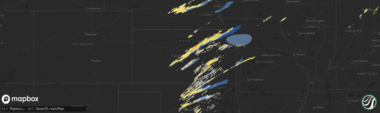
Hail Map in Kansas on April 1, 2025
The weather event in Kansas on April 1, 2025 includes Hail, Wind, and Tornado maps. 11 states and 699 cities were impacted and suffered possible damage. The total estimated number of properties impacted is 36,808.
Want more than just the map?
Turn this storm into a full workflow.
- Owner + property data so you know who to knock
- OnDemand branded weather history reports to win the "did we even have hail?" argument
- RoofTrace estimate so reps stop guessing numbers at the door
Bought this map? Upgrade within 7 days and we'll credit the $230. (10-15 min setup call)
Hail
Wind
Tornado
36,808
Estimated number of impacted properties by a 1.00" hail or larger2,173
Estimated number of impacted properties by a 1.75" hail or larger543
Estimated number of impacted properties by a 2.50" hail or largerStorm reports in Kansas
Kansas
| Date | Description |
|---|---|
| 04/01/20256:27 AM CDT | Transformer blew and wires down near trading post. Time based on dispatch reports and confirmed from radar. |
| 04/01/20256:02 AM CDT | A local report indicates 60 MPH wind near 1 S Tyro |
| 04/01/20255:55 AM CDT | Large tree uprooted onto house. |
| 04/01/20255:36 AM CDT | Em relayed fire department report of 60 mph gusts at intersection. |
| 04/01/20255:23 AM CDT | Downed tree and wires near valley street. Time based on dispatch report and confirmed from radar. |
| 04/01/20254:56 AM CDT | Semi truck blown over on i70 and 86th reported via media and seen on web cameras. |
| 04/01/20254:28 AM CDT | Downed tree limbs and wires near ridge avenue. Time estimated from radar. |
| 04/01/20254:15 AM CDT | Corrects previous tstm wnd dmg report from 2 se maywood. Semi truck blown over on i70 and 86th reported via media and seen on web cameras. |
| 04/01/20254:11 AM CDT | Downed wires near 83rd street. Time estimated from radar. |
| 04/01/20253:20 AM CDT | Personal weather station. |
| 04/01/20253:12 AM CDT | A local report indicates 1.00 inch wind near 2 W Whitewater |
| 04/01/20253:03 AM CDT | Downed wires and power outages near u.s. Highway 159. Time estimated from radar. |
| 04/01/20252:55 AM CDT | Mostly peas and dimes... But a couple of hail stones measured up to 1 inch in diameter. |
| 04/01/20251:35 AM CDT | Pea-sized hail also occurring. |
| 04/01/20251:27 AM CDT | Broken power pole at sw 24th and burmac rd near burrton. |
| 04/01/20251:27 AM CDT | Delayed report: broken power pole at sw 24th and burmac rd near burrton. |
| 04/01/20251:25 AM CDT | Relayed by harvey county em. |
| 04/01/20251:11 AM CDT | Report from mping |
| 04/01/20251:11 AM CDT | Report from mping: quarter |
| 04/01/202512:30 AM CDT | A local report indicates 1.00 inch wind near 3 SE Salina |
| 04/01/202512:30 AM CDT | Kkstroy8. |
| 04/01/202512:30 AM CDT | Picture of 1.5 inch hail received from trained spotter. |
| 04/01/202512:25 AM CDT | Ksdot sensor. |
| 04/01/202512:06 AM CDT | Public weather station. |
| 04/01/202512:04 AM CDT | A local report indicates 62 MPH wind near 1 N Macksville |
| 03/31/202511:57 PM CDT | A local report indicates 1.00 inch wind near 1 W Geneseo |
| 03/31/202511:55 PM CDT | Measured at the lyons airport. |
| 03/31/202511:43 PM CDT | Emergency manager reported ping pong ball size hail just north of chase. |
| 03/31/202511:30 PM CDT | A local report indicates 1.50 inch wind near 3 E Oneida |
| 03/31/202511:14 PM CDT | Mping report. |
| 03/31/202511:14 PM CDT | Report from mping: quarter |
| 03/31/202510:55 PM CDT | Line of trees down. |
| 03/31/202510:55 PM CDT | Hail almost completely covering the ground. |
| 03/31/202510:50 PM CDT | A local report indicates 1.00 inch wind near Ellsworth |
| 03/31/202510:49 PM CDT | Corrects previous hail report from 5 ssw manchester. Corrects previous hail report from 5 ssw manchester. Hail completed covered the roadway on k-18 - making the road s |
| 03/31/202510:35 PM CDT | Trained spotter reported quarter size hail. |
| 03/31/202510:22 PM CDT | A local report indicates 1.00 inch wind near Randolph |
| 03/31/202510:20 PM CDT | A local report indicates 1.00 inch wind near Bushton |
| 03/31/202510:14 PM CDT | Trained spotter reported a tornado on the ground. |
| 03/31/202510:09 PM CDT | Also had wind gusts of 53 mph. |
| 03/31/202510:04 PM CDT | A local report indicates 1.00 inch wind near Riley |
| 03/31/202510:03 PM CDT | A local report indicates 1.00 inch wind near Riley |
| 03/31/20259:53 PM CDT | A local report indicates a tornado near 8 SW Brookville |
| 03/31/20259:50 PM CDT | A local report indicates 70 MPH wind near 5 NW Junction City |
| 03/31/20259:10 PM CDT | A local report indicates 70 MPH wind near 3 N Niles |
| 03/31/20259:00 PM CDT | Report from mping: quarter |
| 03/31/20258:56 PM CDT | A local report indicates 1.00 inch wind near 4 N New Cambria |
| 03/31/20258:56 PM CDT | A local report indicates 1.00 inch wind near 4 N New Cambria |
| 03/31/20258:54 PM CDT | A local report indicates 1.00 inch wind near Bennington |
| 03/31/20258:54 PM CDT | A local report indicates 60 MPH wind near Bennington |
| 03/31/20258:38 PM CDT | A local report indicates 60 MPH wind near 9 WNW Salina |
All States Impacted by Hail Map on April 1, 2025
Cities Impacted by Hail Map on April 1, 2025
- Ochopee, FL
- Enid, OK
- Drummond, OK
- Waukomis, OK
- Lahoma, OK
- Hunter, OK
- Kremlin, OK
- Garber, OK
- Iowa Park, TX
- Lamont, OK
- Burkburnett, TX
- Nardin, OK
- Deer Creek, OK
- Devol, OK
- Grandfield, OK
- Medford, OK
- Tonkawa, OK
- Braman, OK
- Blackwell, OK
- Randlett, OK
- Walters, OK
- Oviedo, FL
- Winter Springs, FL
- Geronimo, OK
- Lawton, OK
- Temple, OK
- South Haven, KS
- Geuda Springs, KS
- Cairo, NE
- Ravenna, NE
- Gibbon, NE
- Wood River, NE
- Grand Island, NE
- Sanford, FL
- Ponca City, OK
- Kearney, NE
- Shelton, NE
- Comanche, OK
- Saint Libory, NE
- Dannebrog, NE
- Baird, TX
- Cisco, TX
- Newkirk, OK
- Duncan, OK
- Saint Paul, NE
- Palmer, NE
- Chapman, NE
- Alda, NE
- Central City, NE
- Marlow, OK
- Maple City, KS
- Dexter, KS
- Archer, NE
- Marquette, NE
- Phillips, NE
- Hordville, NE
- Clarks, NE
- Cedar Vale, KS
- Brookville, KS
- Salina, KS
- Polk, NE
- Stromsburg, NE
- Pleasanton, NE
- Sumner, NE
- Moline, KS
- Ellsworth, KS
- Tescott, KS
- Osceola, NE
- Silver Creek, NE
- Miller, NE
- Rockville, NE
- Augusta, KS
- Leon, KS
- Bennington, KS
- Overton, NE
- Hudson, KS
- Sedan, KS
- El Dorado, KS
- New Cambria, KS
- Minneapolis, KS
- Solomon, KS
- Jewell, KS
- Beloit, KS
- Jamestown, KS
- Beverly, KS
- Norway, KS
- Fredonia, KS
- Ellinwood, KS
- Litchfield, NE
- Ashton, NE
- Loup City, NE
- Elk Falls, KS
- Hazard, NE
- Longton, KS
- Scandia, KS
- Concordia, KS
- Munden, KS
- Belleville, KS
- Chase, KS
- Raymond, KS
- Boelus, NE
- Farwell, NE
- Benedict, KS
- Altoona, KS
- Rising City, NE
- Bellwood, NE
- Shelby, NE
- David City, NE
- Rosalia, KS
- Bushton, KS
- Abilene, KS
- Elba, NE
- Linwood, NE
- Schuyler, NE
- Geneseo, KS
- Lyons, KS
- Lorraine, KS
- Fairbury, NE
- Chanute, KS
- Cuba, KS
- Narka, KS
- Longford, KS
- Eureka, KS
- Rogers, NE
- Wakefield, KS
- Kanopolis, KS
- Marquette, KS
- Erie, KS
- Wolbach, NE
- Savonburg, KS
- Falun, KS
- Clay Center, KS
- Randolph, KS
- Milford, KS
- Riley, KS
- Uniontown, KS
- Beatrice, NE
- Moran, KS
- Elsmore, KS
- Talmage, KS
- Chapman, KS
- Junction City, KS
- Hooper, NE
- Adams, NE
- Pickrell, NE
- Filley, NE
- Kinsley, KS
- Fullerton, NE
- Genoa, NE
- Belgrade, NE
- Lindsborg, KS
- Manhattan, KS
- Fort Scott, KS
- Redfield, KS
- Holyrood, KS
- Claflin, KS
- Burlington, KS
- Gridley, KS
- St John, KS
- Great Bend, KS
- Fremont, NE
- Blue Rapids, KS
- Mason City, NE
- Leonardville, KS
- Amherst, NE
- North Bend, NE
- Ames, NE
- Olsburg, KS
- Hume, MO
- Larned, KS
- Garfield, KS
- Saint Edward, NE
- Pawnee Rock, KS
- Nickerson, NE
- Frankfort, KS
- Saint George, KS
- Westmoreland, KS
- Rich Hill, MO
- Prescott, KS
- Lewis, KS
- Monroe, NE
- Lindsay, NE
- Humphrey, NE
- Onaga, KS
- Butler, MO
- Vermillion, KS
- Bruno, NE
- Abie, NE
- Columbus, NE
- Corning, KS
- Centralia, KS
- Howells, NE
- Pilger, NE
- Wisner, NE
- Havensville, KS
- Montrose, MO
- Seneca, KS
- Goff, KS
- Soldier, KS
- Beemer, NE
- Clinton, MO
- Circleville, KS
- Wetmore, KS
- Sabetha, KS
- Prague, NE
- Dodge, NE
- Morse Bluff, NE
- Cedar Bluffs, NE
- Malmo, NE
- Arlington, NE
- Scribner, NE
- Herman, NE
- Winslow, NE
- Blair, NE
- Tekamah, NE
- Craig, NE
- Dawson, NE
- Bern, KS
- Fairview, KS
- Netawaka, KS
- Powhattan, KS
- Calhoun, MO
- Morrill, KS
- Appleton City, MO
- Oneida, KS
- Horton, KS
- Green, KS
- Lincoln, MO
- Windsor, MO
- Ionia, MO
- Whiting, KS
- Hiawatha, KS
- Robinson, KS
- Holton, KS
- Murdock, NE
- Weeping Water, NE
- Manley, NE
- Louisville, NE
- Murray, NE
- Nehawka, NE
- Plattsmouth, NE
- Pacific Junction, IA
- Glenwood, IA
- Highland, KS
- Little River, KS
- White Cloud, KS
- Malvern, IA
- Silver City, IA
- Henderson, IA
- Hastings, IA
- Macedonia, IA
- Griswold, IA
- Lewis, IA
- Carson, IA
- Oakland, IA
- Walnut, IA
- Hancock, IA
- Avoca, IA
- Atlantic, IA
- Everest, KS
- Muscotah, KS
- Marne, IA
- Troy, KS
- Denton, KS
- Oregon, MO
- Brayton, IA
- Anita, IA
- Forest City, MO
- Byers, KS
- Pratt, KS
- Amazonia, MO
- Fillmore, MO
- Savannah, MO
- Wathena, KS
- Rosendale, MO
- Turon, KS
- Bendena, KS
- Helena, MO
- Saint Joseph, MO
- Rea, MO
- King City, MO
- Guilford, MO
- Union Star, MO
- Independence, MO
- Kansas City, MO
- Lancaster, KS
- Atchison, KS
- Elwood, KS
- Gypsum, KS
- Assaria, KS
- Stafford, KS
- Plevna, KS
- Stanberry, MO
- Bolckow, MO
- Cosby, MO
- Cunningham, KS
- Abbyville, KS
- Arlington, KS
- Hutchinson, KS
- South Hutchinson, KS
- Partridge, KS
- Darlington, MO
- Nickerson, KS
- Buhler, KS
- Burrton, KS
- Galva, KS
- Mcpherson, KS
- Moundridge, KS
- Inman, KS
- Albany, MO
- McFall, MO
- Canton, KS
- Hillsboro, KS
- Lehigh, KS
- Hope, KS
- Enterprise, KS
- Woodbine, KS
- Fort Riley, KS
- Milan, MO
- Alta Vista, KS
- Dwight, KS
- White City, KS
- Herington, KS
- Worthington, MO
- Livonia, MO
- Queen City, MO
- Wamego, KS
- Glenwood, MO
- Alma, KS
- Council Grove, KS
- Belvue, KS
- Fairview, OK
- Seiling, OK
- Goddard, KS
- Saint Marys, KS
- Maple Hill, KS
- Paxico, KS
- Bloomfield, IA
- Downing, MO
- Memphis, MO
- Lancaster, MO
- Viola, KS
- Wichita, KS
- Cleo Springs, OK
- Valley Center, KS
- Colwich, KS
- Maize, KS
- Helena, OK
- Kechi, KS
- Harveyville, KS
- Eskridge, KS
- Pulaski, IA
- Milton, IA
- Longdale, OK
- Ringwood, OK
- Rossville, KS
- Delia, KS
- Mayetta, KS
- Jet, OK
- Goltry, OK
- Milan, KS
- Newton, KS
- Clearwater, KS
- Topeka, KS
- Auburn, KS
- Burlingame, KS
- Ames, OK
- Isabella, OK
- Okeene, OK
- Belle Plaine, KS
- Wellington, KS
- Peck, KS
- Mayfield, KS
- Silver Lake, KS
- Meno, OK
- Caldwell, KS
- Wakita, OK
- Nash, OK
- Carrier, OK
- Pond Creek, OK
- Canton, OK
- Nauvoo, IL
- Keokuk, IA
- Montrose, IA
- Whitewater, KS
- Sedgwick, KS
- Mulvane, KS
- Wakarusa, KS
- Derby, KS
- Haysville, KS
- Geary, OK
- Thomas, OK
- Weatherford, OK
- Corn, OK
- Potwin, KS
- Towanda, KS
- Perry, KS
- Lecompton, KS
- Carbondale, KS
- Benton, KS
- Burns, KS
- Niota, IL
- Tecumseh, KS
- Grantville, KS
- Dallas City, IL
- Douglass, KS
- Rose Hill, KS
- Carthage, IL
- Berryton, KS
- Oskaloosa, KS
- Meriden, KS
- Ozawkie, KS
- Andover, KS
- Hitchcock, OK
- Matfield Green, KS
- Olpe, KS
- Cassoday, KS
- Baylis, IL
- Hydro, OK
- Cedar Point, KS
- Watonga, OK
- Greenfield, OK
- Cottonwood Falls, KS
- Peabody, KS
- Lawrence, KS
- McLouth, KS
- Tonganoxie, KS
- Leavenworth, KS
- Hartford, KS
- Oxford, KS
- Hennessey, OK
- Bison, OK
- Fairmont, OK
- Cordell, OK
- Emporia, KS
- Kingfisher, OK
- Carnegie, OK
- Mountain View, OK
- Calumet, OK
- Gotebo, OK
- Udall, KS
- Winfield, KS
- Douglas, OK
- Neosho Rapids, KS
- Billings, OK
- Okarche, OK
- Roosevelt, OK
- Fort Cobb, OK
- Vernon, TX
- Burden, KS
- Atlanta, KS
- Rock, KS
- Arkansas City, KS
- Davidson, OK
- Loyal, OK
- Marshall, OK
- Reading, KS
- Madison, KS
- Linwood, KS
- Eudora, KS
- Red Rock, OK
- Southard, OK
- Cambridge, KS
- Hollister, OK
- Loveland, OK
- Frederick, OK
- Omega, OK
- Latham, KS
- Lebo, KS
- Binger, OK
- Hinton, OK
- Hamilton, KS
- Marland, OK
- Colony, OK
- Bonner Springs, KS
- Osage City, KS
- Grenola, KS
- Piedmont, KS
- Severy, KS
- Howard, KS
- Apache, OK
- Burbank, OK
- Holt, MO
- Kearney, MO
- Lawson, MO
- Rayville, MO
- Excelsior Springs, MO
- Hamilton, MO
- Polo, MO
- Lathrop, MO
- Kingston, MO
- Melvern, KS
- Crescent, OK
- Elgin, OK
- Quenemo, KS
- Cashion, OK
- Guthrie, OK
- Liberty, MO
- Smithville, MO
- Plattsburg, MO
- Cameron, MO
- Kansas City, KS
- Platte City, MO
- Waldron, MO
- Lansing, KS
- Farley, MO
- Turney, MO
- Trimble, MO
- Chattanooga, OK
- Rushville, MO
- De Kalb, MO
- Fort Leavenworth, KS
- Kidder, MO
- Easton, KS
- Dearborn, MO
- Weston, MO
- Camden Point, MO
- Faucett, MO
- Agency, MO
- Gower, MO
- Edgerton, MO
- Cummings, KS
- Nortonville, KS
- Stewartsville, MO
- Effingham, KS
- Osborn, MO
- Easton, MO
- Basehor, KS
- Winchester, KS
- Orrick, MO
- Missouri City, MO
- Riverside, MO
- Buckner, MO
- Sibley, MO
- Fletcher, OK
- Dawn, MO
- Richmond, MO
- Camden, MO
- Norborne, MO
- Carrollton, MO
- Henrietta, MO
- Cowgill, MO
- Braymer, MO
- Hardin, MO
- Bogard, MO
- Cyril, OK
- Tina, MO
- Ludlow, MO
- Cement, OK
- Anadarko, OK
- Breckenridge, MO
- Oak Grove, MO
- Levasy, MO
- Wellington, MO
- Lexington, MO
- Napoleon, MO
- Chickasha, OK
- Kaw City, OK
- Shidler, OK
- Fairfax, OK
- Cache, OK
- Mulhall, OK
- Orlando, OK
- Pawhuska, OK
- Stillwater, OK
- Perkins, OK
- Coyle, OK
- Perry, OK
- Ripley, OK
- Pawnee, OK
- Glencoe, OK
- Fall River, KS
- Toronto, KS
- Indiahoma, OK
- Faxon, OK
- Fort Sill, OK
- Morrison, OK
- Medicine Park, OK
- Oklahoma City, OK
- Ralston, OK
- Yale, OK
- Norman, OK
- Electra, TX
- Thorntown, IN
- Lebanon, IN
- Blanchard, OK
- Newcastle, OK
- Edmond, OK
- Rush Springs, OK
- Ninnekah, OK
- Harrold, TX
- Yates Center, KS
- Arcadia, OK
- Buffalo, KS
- Choctaw, OK
- Harrah, OK
- Cushing, OK
- Maramec, OK
- Cleveland, OK
- Drumright, OK
- Jennings, OK
- Hominy, OK
- Wichita Falls, TX
- Frankfort, IN
- Luther, OK
- Jones, OK
- Spencer, OK
- Sheppard Afb, TX
- Terlton, OK
- Osage, OK
- Maysville, OK
- Newalla, OK
- Throckmorton, TX
- Bethany, OK
- Foster, OK
- Lindsay, OK
- Washington, OK
- Mcloud, OK
- Byers, TX
- Mannford, OK
- Prue, OK
- Pauls Valley, OK
- Elmore City, OK
- Wayne, OK
- Paoli, OK
- Copan, OK
- Shawnee, OK
- Newcastle, TX
- Depew, OK
- Stroud, OK
- Bartlesville, OK
- Dewey, OK
- Wann, OK
- Lenapah, OK
- S Coffeyville, OK
- Caney, KS
- Tyro, KS
- Dearing, KS
- Liberty, KS
- Coffeyville, KS
- Bartlett, KS
- Edna, KS
- Welch, OK
- Altamont, KS
- Oswego, KS
- Mound Valley, KS
- Bristow, OK
- Bronson, KS
- Sparks, OK
- Prague, OK
- La Fontaine, IN
- Wabash, IN
- Lagro, IN
- Wanette, OK
- Olney, TX
- Byars, OK
- Owasso, OK
- Huntington, IN
- Stratford, OK
- Collinsville, OK
- Ada, OK
- Wynnewood, OK
- Paden, OK
- Boley, OK
- Castle, OK
- Columbia City, IN
- Roanoke, IN
- Davis, OK
- Fort Wayne, IN
- Arcola, IN
- Decatur, IN
- Monroeville, IN
- Convoy, OH
- Payne, OH
- Haviland, OH
- Paulding, OH
- Cecil, OH
- Fulton, KS
- Pleasanton, KS
- Foster, MO
- Marion, IN
- Sweetser, IN
- Maud, OK
- Roff, OK
- Sulphur, OK
- Weleetka, OK
- Okemah, OK
- Beggs, OK
- Konawa, OK
- Mounds, OK
- Van Wert, OH
- Sand Springs, OK
- Tulsa, OK
- Skiatook, OK
- Sperry, OK
- Talala, OK
- Vera, OK
- Durham, KS
- Modesto, CA


