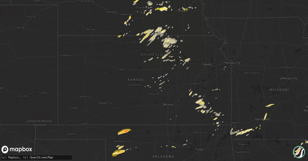
Hail Map in Kansas on April 1, 2015
Get this storm
April 1 map
$229
one time, instant access
Download today. No call, no setup
Keep the $229
Bought the map and want the full workflow? Apply the entire $229 to a subscription within 7 days. None of it is wasted.
Every map, not just this one
This buys you this map. Subscription and you get every map we run, in the markets you choose from a few cities to whole states to nationwide. Plus real-time alerts the moment a storm fires.
Contact data
Name, contact info, occupancy, even credit band for addresses in the footprint. You go from where it hit to who to call.
Become the source they trust
Unlimited branding weather history reports on demand. You already have the documented answer ready for the property owner, and you are the one who showed up with it.
Property data and RoofTrace estimates
Pull up any address you have got, its value and the exact code rules for that jurisdiction, straight from One Click Code. Then RoofTrace estimates the squares, pitch, and roof value, priced the way you price.
Storm reports in Kansas
Kansas
| Date | Description |
|---|---|
| 04/01/20155:00 AM CDT | Two power poles were knocked down. |
| 04/01/20152:19 AM CDT | Measured on davis weather station on top of a shed. |
| 04/01/201512:52 AM CDT | A local report indicates 1.00 inch wind near 2 N BARNARD |
| 04/01/201512:45 AM CDT | Mainly pea to penny size hail but a few up to quarter size. |
| 03/31/20159:09 PM CDT | Via web report |
| 03/31/20158:05 PM CDT | Near zero visibility in blowing dust. |
| 03/31/20157:56 PM CDT | A local report indicates 59 MPH wind near GOODLAND |
All States Impacted by Hail Map on April 1, 2015
Cities Impacted by Hail Map on April 1, 2015
- Fort Worth, TX
- Rochelle, TX
- Saint Jo, TX
- Haslet, TX
- Weatherford, TX
- Azle, TX
- Springtown, TX
- Randolph, NE
- Osmond, NE
- Mclean, NE
- Arnett, OK
- Vici, OK
- Camargo, OK
- Bartlett, KS
- Chetopa, KS
- Como, TX
- Quitman, TX
- Yantis, TX
- Galva, KS
- Roxbury, KS
- Mcpherson, KS
- Robeline, LA
- Provencal, LA
- Natchitoches, LA
- Franklin, AR
- Horseshoe Bend, AR
- Sage, AR
- Melbourne, AR
- Manhattan, KS
- Junction City, KS
- Wamego, KS
- Saint George, KS
- Buffalo, OK
- Memphis, TN
- Arlington, TN
- Millington, TN
- Fall River, KS
- Toronto, KS
- Virgil, KS
- Greenleaf, KS
- Barnes, KS
- Newark, TX
- Keller, TX
- Doniphan, NE
- Grand Island, NE
- Strafford, MO
- Fair Grove, MO
- Springfield, MO
- Mead, OK
- Pottsboro, TX
- Kingston, OK
- Calera, OK
- Cartwright, OK
- Benedict, KS
- Hardy, AR
- Mammoth Spring, AR
- Millsap, TX
- Poolville, TX
- Bradshaw, NE
- Polk, NE
- Pittsburg, TX
- Henderson, MN
- Edgewood, TX
- Paducah, KY
- Belle Plaine, MN
- Jordan, MN
- Sterling, KS
- Altamont, KS
- Parsons, KS
- Mound Valley, KS
- Oswego, KS
- Benedict, NE
- Stromsburg, NE
- Belleville, KS
- Republic, KS
- Mankato, KS
- Courtland, KS
- Hardy, NE
- Lebanon, KS
- Oak, NE
- Burr Oak, KS
- Esbon, KS
- Superior, NE
- Nelson, NE
- Guide Rock, NE
- Red Cloud, NE
- Gresham, NE
- Shelby, NE
- Surprise, NE
- Ulysses, NE
- Malvern, AR
- Lohn, TX
- Richland Springs, TX
- Anderson, MO
- Goodman, MO
- Stella, MO
- Hot Springs National Park, AR
- Eureka, KS
- Madison, KS
- Grannis, AR
- Genoa, NE
- Saint Edward, NE
- Leigh, NE
- Haddam, KS
- Hebron, NE
- Carleton, NE
- Davenport, NE
- Ruskin, NE
- Deshler, NE
- Hordville, NE
- Lindsay, NE
- Madison, NE
- Battle Creek, NE
- Albion, NE
- Newman Grove, NE
- Laredo, TX
- Coleridge, NE
- Belden, NE
- Laurel, NE
- Newcastle, NE
- Pierce, NE
- Hoskins, NE
- Henderson, NE
- Hampton, NE
- Weeping Water, NE
- Manley, NE
- Roanoke, TX
- Linn, KS
- Palmer, KS
- Watson, OK
- Wilcox, NE
- Axtell, NE
- Menard, TX
- Mason, TX
- London, TX
- Eads, TN
- Boelus, NE
- Sharon, OK
- Humphrey, NE
- Hamilton, KS
- Gillham, AR
- Dierks, AR
- Wickes, AR
- Newhope, AR
- Umpire, AR
- Inavale, NE
- Le Mars, IA
- Durham, KS
- Mooreland, OK
- Freedom, OK
- Staplehurst, NE
- Beaver Crossing, NE
- York, NE
- Seward, NE
- Utica, NE
- Waco, NE
- Leachville, AR
- Arbyrd, MO
- Cokato, MN
- Kemp, TX
- Wills Point, TX
- Kaufman, TX
- Muenster, TX
- Williford, AR
- Couch, MO
- Ravenden Springs, AR
- Myrtle, MO
- Ravenden, AR
- Pocahontas, AR
- Giltner, NE
- Trumbull, NE
- Cassville, MO
- Bethel Springs, TN
- Guion, AR
- Mount Pleasant, AR
- Ash Flat, AR
- Enterprise, KS
- Edna, KS
- Arlington, MN
- Phillipsburg, KS
- Dixon, NE
- Morrowville, KS
- Narka, KS
- Cuba, KS
- Washington, KS
- Agenda, KS
- Ramer, TN
- Adamsville, TN
- Selmer, TN
- Hildreth, NE
- Minden, NE
- Buffalo, MO
- Long Lane, MO
- Windyville, MO
- Elkland, MO
- Lebanon, MO
- Phillipsburg, MO
- Hutchinson, MN
- Emory, TX
- Fruitvale, TX
- Cleveland, OK
- Hominy, OK
- Pawnee, OK
- Barnard, KS
- Beloit, KS
- Alexandria, NE
- Fairbury, NE
- Garnett, KS
- Elk Point, SD
- Ponca, NE
- Purdy, MO
- Wheaton, MO
- Rocky Comfort, MO
- Butterfield, MO
- Monett, MO
- Verona, MO
- Exeter, MO
- Dakota City, NE
- Sioux City, IA
- Gaylord, MN
- McCune, KS
- Clyde, KS
- Clifton, KS
- Morganville, KS
- Fredonia, KS
- Fairview, MO
- Aurora, MO
- Mount Pleasant, TX
- Webber, KS
- Westfield, IA
- Como, MS
- Senatobia, MS
- Hubbell, NE
- Welda, KS
- Cherryvale, KS
- Clay Center, KS
- Longford, KS
- Wakefield, NE
- Rector, AR
- Lincoln, NE
- Murdock, NE
- Byron, NE
- Huntsville, TX
- New Waverly, TX
- Pacific Junction, IA
- Glenwood, IA
- Cordova, TN
- Collierville, TN
- Hornersville, MO
- Merrill, IA
- Hinton, IA
- Minneapolis, KS
- Neodesha, KS
- Salix, IA
- Sergeant Bluff, IA
- Farwell, NE
- Dannebrog, NE
- Cairo, NE
- Rockville, NE
- Ravenna, NE
- Smith Center, KS
- Chireno, TX
- Matfield Green, KS
- Durant, OK
- Chester, NE
- Canton, SD
- Inwood, IA
- Princeton, MN
- Dalbo, MN
- Aurora, NE
- Miltonvale, KS
- Lindsborg, KS
- Akron, IA
- Ireton, IA
- Granby, MO
- Stark City, MO
- Bluejacket, OK
- Vinita, OK
- Crane, MO
- Welch, OK
- Fort Riley, KS
- Garvin, OK
- Windom, KS
- Wolbach, NE
- Gordonville, TX
- Whitesboro, TX
- Mason, TN
- Stanton, TN
- Somerville, TN
- Mahaska, KS
- Springfield, MN
- Olathe, KS
- Gardner, KS
- Bismarck, AR
- Traskwood, AR
- Donaldson, AR
- Lonsdale, AR
- Pearcy, AR
- Benton, AR
- Chapman, NE
- Marquette, NE
- Central City, NE
- Gatewood, MO
- Santo, TX
- Mineral Wells, TX
- Neosho, MO
- Fullerton, NE
- Oxford, KS
- Drummonds, TN
- Allen, NE
- Concord, NE
- Longton, KS
- Naponee, NE
- La Vernia, TX
- Adkins, TX
- Brownwood, TX
- Brookesmith, TX
- Fairview, OK
- Wakefield, KS
- Fairfax, OK
- Harvard, NE
- Crab Orchard, NE
- Chase, KS
- Byhalia, MS
- Red Banks, MS
- Phillips, NE
- Perry, OK
- Stanton, NE
- Douglas, OK
- Early, TX
- Seiling, OK
- Chester, OK
- Raymond, NE
- Davey, NE
- Thackerville, OK
- Norfolk, NE
- Royal, AR
- Bonnerdale, AR
- Bangs, TX
- Waterville, KS
- Bremen, KS
- Marysville, KS
- Saint Paul, KS
- Leedey, OK
- Riley, KS
- Delphos, KS
- Lyons, KS
- Thayer, KS
- Moran, KS
- La Harpe, KS
- Galesburg, KS
- Caddo Gap, AR
- Greenwood, NE
- Alvo, NE
- Waverly, NE
- Clever, MO
- Highlandville, MO
- Monroe, NE
- Seneca, MO
- Justin, TX
- Hollenberg, KS
- Leonardville, KS
- Randolph, KS
- Jansen, NE
- Lenexa, KS
- Columbus, KS
- Larchwood, IA
- Assaria, KS
- Milford, KS
- Buffalo, KS
- Severy, KS
- Yates Center, KS
- Howard, KS
- Munden, KS
- Formoso, KS
- Belvidere, NE
- Gilead, NE
- Jewell, KS
- Washburn, MO
- Republican City, NE
- Blue Springs, NE
- Luverne, MN
- Kenneth, MN
- Inman, KS
- Winfield, KS
- Galena, MO
- Hickory Valley, TN
- Waterbury, NE
- Hubbard, NE
- Emerson, NE
- Chelsea, OK
- Gypsum, KS
- Abilene, KS
- Wynot, NE
- Hartington, NE
- Tiff City, MO
- Wyandotte, OK
- Grove, OK
- Oakland, TN
- Archer, NE
- Alba, TX
- Chapman, KS
- Concordia, KS
- Malcolm, NE
- Bloomington, NE
- Marquette, KS
- Ellsworth, KS
- Howard Lake, MN
- Chanute, KS
- Dwight, KS
- Alma, KS
- Alta Vista, KS
- Gainesville, TX
- Stillwater, OK
- Jackson, NE
- Sylvan Grove, KS
- Hunter, KS
- Burrton, KS
- Moundridge, KS
- Altoona, KS
- Platte Center, NE
- Ashton, IA
- Virginia, NE
- Lewiston, NE
- Glencoe, OK
- Wood River, NE
- Falls City, NE
- Jefferson, SD
- Rhome, TX
- Kearney, NE
- Long Island, KS
- Alma, NE
- Meadow Grove, NE
- Alva, OK


