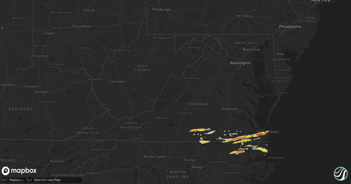
Hail Map in Virginia on March 31, 2017
Get this storm
March 31 map
$229
one time, instant access
Download today. No call, no setup
Keep the $229
Bought the map and want the full workflow? Apply the entire $229 to a subscription within 7 days. None of it is wasted.
Every map, not just this one
This buys you this map. Subscription and you get every map we run, in the markets you choose from a few cities to whole states to nationwide. Plus real-time alerts the moment a storm fires.
Contact data
Name, contact info, occupancy, even credit band for addresses in the footprint. You go from where it hit to who to call.
Become the source they trust
Unlimited branding weather history reports on demand. You already have the documented answer ready for the property owner, and you are the one who showed up with it.
Property data and RoofTrace estimates
Pull up any address you have got, its value and the exact code rules for that jurisdiction, straight from One Click Code. Then RoofTrace estimates the squares, pitch, and roof value, priced the way you price.
Storm reports in Virginia
Virginia
| Date | Description |
|---|---|
| 03/31/20176:00 PM CDT | Quarter size and greater hail reported once again. |
| 03/31/20175:48 PM CDT | Quarter size hail also reported. |
| 03/31/20175:42 PM CDT | . |
| 03/31/20175:38 PM CDT | Wind gust to 55 mph. |
| 03/31/20175:20 PM CDT | Tornado reported at centerville turnpike and appalachian. Church has been destroyed. Relayed by 911. . |
| 03/31/20175:17 PM CDT | Tornado sighted on ground with flying debris. Ping pong ball size hail. Kempsville rd and volvo pkwy. |
| 03/31/20175:17 PM CDT | . |
| 03/31/20175:14 PM CDT | Hail at greenbrier mall. |
| 03/31/20175:05 PM CDT | . |
| 03/31/20175:04 PM CDT | . |
| 03/31/20174:57 PM CDT | Last point at which tornado damage was evident from tornado that originated in suffolk... West of the great dismal swamp. Some tree damage evident near george washingto |
| 03/31/20174:56 PM CDT | . |
| 03/31/20174:47 PM CDT | . |
| 03/31/20174:33 PM CDT | Damage survey indicated tornado touchdown in the vicinity of white marsh rd. Several trees down... Outbuilding destroyed... And wall of large outbuilding blown in. Torn |
| 03/31/20174:12 PM CDT | Very strong winds as well. |
| 03/31/20173:56 PM CDT | Ping pong ball size hail. |
| 03/31/20173:54 PM CDT | Awning blown off a gas station in franklin. |
| 03/31/20173:38 PM CDT | . |
| 03/31/20173:12 PM CDT | A local report indicates 1.00 inch wind near 4 ESE SAXE |
| 03/31/20172:59 PM CDT | A local report indicates 1.75 inch wind near 3 NNE CLOVER |
| 03/31/20177:53 AM CDT | One tree down on a power line along halifax rd. |
All States Impacted by Hail Map on March 31, 2017
Cities Impacted by Hail Map on March 31, 2017
- Carrsville, VA
- Boykins, VA
- Pleasant Hill, NC
- Courtland, VA
- Portsmouth, VA
- Garysburg, NC
- Skippers, VA
- Chesapeake, VA
- Norfolk, VA
- Newsoms, VA
- Suffolk, VA
- Emporia, VA
- Franklin, VA
- Gaston, NC
- Drewryville, VA
- Virginia Beach, VA
- Capron, VA
- Branchville, VA
- Lawrenceville, VA
- Windsor, VA
- Camden, NC
- Borger, TX
- Alberta, VA
- Dundas, VA
- Kenbridge, VA
- South Hill, VA
- Pendleton, NC
- Elizabeth City, NC
- Clarksville, VA
- Henderson, NC
- Kelford, NC
- Cofield, NC
- Colerain, NC
- Ahoskie, NC
- Scotland Neck, NC
- Roxobel, NC
- Aulander, NC
- Rich Square, NC
- Panhandle, TX
- Fritch, TX
- Clover, VA
- Randolph, VA
- Scottsburg, VA
- Margarettsville, NC
- Como, NC
- Dalhart, TX
- Bullock, NC
- Manson, NC
- Norlina, NC
- Boydton, VA
- Chase City, VA
- Baskerville, VA
- Wylliesburg, VA
- Crystal Hill, VA
- Nathalie, VA
- Drakes Branch, VA
- Saxe, VA
- Keysville, VA
- Halifax, VA
- Shiloh, NC
- Shawboro, NC
- Woodland, NC
- Lewiston Woodville, NC
- Perryton, TX
- Gates, NC
- Murfreesboro, NC
- White Plains, VA
- Sedley, VA
- Wakefield, VA
- Victoria, VA
- Lunenburg, VA
- Belvidere, NC
- Hobbsville, NC
- Sunbury, NC
- Skipwith, VA
- Red Oak, VA
- Jarratt, VA
- Stony Creek, VA
- Yale, VA
- Brodnax, VA
- Currituck, NC
- Moyock, NC
- Gatesville, NC
- Eure, NC
- Seaboard, NC
- Turpin, OK
- Harrellsville, NC
- Balko, OK
- Stinnett, TX


