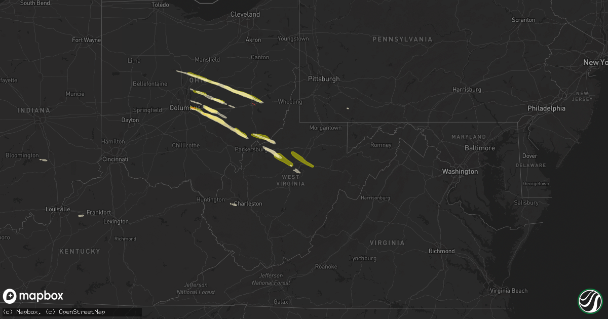
Hail Map in West Virginia on March 30, 2024
Get this storm
March 30 map
$229
one time, instant access
Download today. No call, no setup
Keep the $229
Bought the map and want the full workflow? Apply the entire $229 to a subscription within 7 days. None of it is wasted.
Every map, not just this one
This buys you this map. Subscription and you get every map we run, in the markets you choose from a few cities to whole states to nationwide. Plus real-time alerts the moment a storm fires.
Contact data
Name, contact info, occupancy, even credit band for addresses in the footprint. You go from where it hit to who to call.
Become the source they trust
Unlimited branding weather history reports on demand. You already have the documented answer ready for the property owner, and you are the one who showed up with it.
Property data and RoofTrace estimates
Pull up any address you have got, its value and the exact code rules for that jurisdiction, straight from One Click Code. Then RoofTrace estimates the squares, pitch, and roof value, priced the way you price.
Storm reports in West Virginia
West Virginia
| Date | Description |
|---|---|
| 03/29/20248:35 PM CDT | 2 large trees down blocking the road. |
| 03/29/20247:50 PM CDT | County 911 center reports tree down on shilo rd near moatsville. |
| 03/29/20247:44 PM CDT | Corrects previous tstm wnd dmg report from 2 ssw buckhannon. 2 large trees down blocking the road. |
| 03/29/20247:43 PM CDT | Report from mping: quarter |
| 03/29/20247:42 PM CDT | County 911 reported two large trees down on norvell drive in buckhannon. Time estimated from radar. |
| 03/29/20247:30 PM CDT | Trained spotter reports lots of nickel sized hail and several a bit bigger than a quarter. Strong winds as well. |
All States Impacted by Hail Map on March 30, 2024
Cities Impacted by Hail Map on March 30, 2024
- Marion, OH
- Mount Gilead, OH
- Cardington, OH
- Edison, OH
- Fredericktown, OH
- Chesterville, OH
- Mount Vernon, OH
- Gambier, OH
- Howard, OH
- Walhonding, OH
- Sunbury, OH
- Warsaw, OH
- Coshocton, OH
- Croton, OH
- Johnstown, OH
- Utica, OH
- Newark, OH
- Columbus, OH
- Pataskala, OH
- New Albany, OH
- Blacklick, OH
- Newcomerstown, OH
- Kimbolton, OH
- Cambridge, OH
- Plainfield, OH
- Granville, OH
- Heath, OH
- West Lafayette, OH
- Reynoldsburg, OH
- Pickerington, OH
- Baltimore, OH
- Nashport, OH
- Hebron, OH
- Buckeye Lake, OH
- Thornville, OH
- Millersport, OH
- Lore City, OH
- Salesville, OH
- Glenford, OH
- Pleasantville, OH
- Rushville, OH
- Somerset, OH
- Thurston, OH
- Zanesville, OH
- New Lexington, OH
- Junction City, OH
- Lowell, OH
- Roseville, OH
- Mount Perry, OH
- Whipple, OH
- Marietta, OH
- Reno, OH
- Newport, OH
- New Matamoras, OH
- Saint Marys, WV
- Crooksville, OH
- Corning, OH
- Malta, OH
- Stockport, OH
- Friendly, WV
- Waterford, OH
- Vincent, OH
- Chesterhill, OH
- Mill Run, PA
- New Milton, WV
- Fleming, OH
- Cairo, WV
- Harrisville, WV
- Waverly, WV
- Petroleum, WV
- Berea, WV
- Pullman, WV
- Auburn, WV
- Salem, WV
- Jane Lew, WV
- Weston, WV
- Camden, WV
- Buckhannon, WV
- Horner, WV
- Pennsboro, WV
- West Union, WV
- Coxs Mills, WV
- Troy, WV
- Smithville, WV
- Linn, WV
- Glenville, WV
- Alum Bridge, WV
- Vincennes, IN
- Decker, IN
- Petersburg, IN
- Quaker City, OH
- Orlando, WV
- Walkersville, WV
- Burnsville, WV
- Winslow, IN
- Crossville, IL
- Carmi, IL
- Enfield, IL
- Monroe City, IN
- Hazleton, IN
- Poseyville, IN
- New Harmony, IN
- Haubstadt, IN
- Cynthiana, IN
- Wadesville, IN
- Evansville, IN
- Barboursville, WV
- Boonville, IN
- Sod, WV
- Hurricane, WV
- Saint Albans, WV
- Chandler, IN
- Elberfeld, IN
- Ellenboro, WV
- Lancaster, OH
- Tennyson, IN
- Tornado, WV
- Finchville, KY
- Shelbyville, KY
- Otwell, IN
- Columbus, IN
- Freetown, IN
- Seymour, IN
- Flagler, CO
- Hugo, CO


