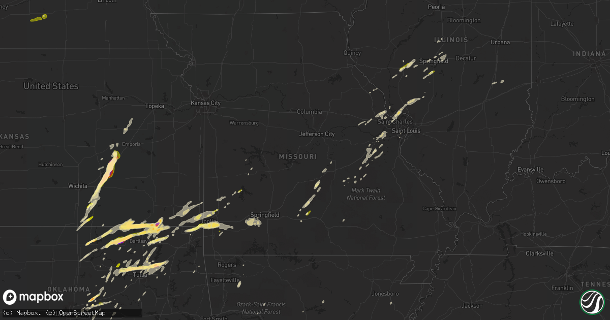
Hail Map in Missouri on March 30, 2016
Get this storm
March 30 map
$229
one time, instant access
Download today. No call, no setup
Keep the $229
Bought the map and want the full workflow? Apply the entire $229 to a subscription within 7 days. None of it is wasted.
Every map, not just this one
This buys you this map. Subscription and you get every map we run, in the markets you choose from a few cities to whole states to nationwide. Plus real-time alerts the moment a storm fires.
Contact data
Name, contact info, occupancy, even credit band for addresses in the footprint. You go from where it hit to who to call.
Become the source they trust
Unlimited branding weather history reports on demand. You already have the documented answer ready for the property owner, and you are the one who showed up with it.
Property data and RoofTrace estimates
Pull up any address you have got, its value and the exact code rules for that jurisdiction, straight from One Click Code. Then RoofTrace estimates the squares, pitch, and roof value, priced the way you price.
Storm reports in Missouri
Missouri
| Date | Description |
|---|---|
| 03/30/20164:22 PM CDT | Several large trees blown over and power outages in town. |
| 03/30/20161:30 PM CDT | A local report indicates 1.00 inch wind near BYRNES MILL |
| 03/30/20161:00 PM CDT | A local report indicates 1.00 inch wind near FORT LEONARD WOOD |
| 03/30/201612:00 PM CDT | Nickel to quarter size hail. |
| 03/30/201611:55 AM CDT | Report via social media. |
| 03/29/201610:55 PM CDT | A local report indicates 1.25 inch wind near DIAMOND |
| 03/29/20169:52 PM CDT | A local report indicates 1.00 inch wind near 1 E ALBA |
| 03/29/20169:45 PM CDT | Part of a silo was blown off and partially blocking the intersection of highway 96 and cr188. |
| 03/29/20169:43 PM CDT | Severe thunderstorm wind gusts downed power lines along highway 43 east of carl junction. Hail was also reported in carl...however...they were not able to provide a siz |
All States Impacted by Hail Map on March 30, 2016
Cities Impacted by Hail Map on March 30, 2016
- O'Fallon, MO
- Old Monroe, MO
- Tolar, TX
- Stephenville, TX
- Bluff Dale, TX
- Mountain Grove, MO
- Norwood, MO
- Alvarado, TX
- Castle, OK
- Boley, OK
- Cherryville, MO
- Salem, MO
- Agra, OK
- Perkins, OK
- Osceola, MO
- Lowry City, MO
- Chandler, OK
- Carney, OK
- Tryon, OK
- Wellston, OK
- Rising Star, TX
- May, TX
- Comanche, TX
- Sidney, TX
- De Leon, TX
- Springfield, IL
- Italy, TX
- Waxahachie, TX
- Claremore, OK
- Ben Wheeler, TX
- Tyler, TX
- Murchison, TX
- Lindale, TX
- Sedan, KS
- Pawhuska, OK
- Copan, OK
- Niotaze, KS
- Caney, KS
- Peru, KS
- Maramec, OK
- Yale, OK
- Tulsa, OK
- Skiatook, OK
- Sperry, OK
- Prue, OK
- Sand Springs, OK
- Crandall, TX
- Oklahoma City, OK
- Wynona, OK
- Bourbon, MO
- McCune, KS
- Cherokee, KS
- Columbus, KS
- Pittsburg, KS
- Scammon, KS
- Weir, KS
- Altamont, KS
- Girard, KS
- Oswego, KS
- West Mineral, KS
- Galena, KS
- Benton, AR
- Bauxite, AR
- Seagoville, TX
- Crossett, AR
- Fountain Hill, AR
- Monticello, AR
- Tillar, AR
- Hamburg, AR
- Dermott, AR
- McGehee, AR
- New Berlin, IL
- Ryan, OK
- Sparkman, AR
- Sparks, OK
- Weatherford, TX
- Strawn, TX
- Breckenridge, TX
- Caddo, TX
- Braxton, MS
- Brandon, MS
- Mendenhall, MS
- Clay Center, NE
- Saronville, NE
- S Coffeyville, OK
- Cottonwood Falls, KS
- Rock, KS
- Winfield, KS
- Newburg, MO
- Plato, MO
- Duke, MO
- Bagley, IA
- Guthrie Center, IA
- Yale, IA
- Panora, IA
- Dawson, IA
- Jamaica, IA
- Macomb, MO
- Owasso, OK
- Cleveland, OK
- Cushing, OK
- Jennings, OK
- Terlton, OK
- Mannford, OK
- Eureka, MO
- Wildwood, MO
- Chesterfield, MO
- Saint Albans, MO
- Pacific, MO
- Labadie, MO
- Gray Summit, MO
- Oologah, OK
- Kansas, OK
- Luther, OK
- Harrah, OK
- Clinton, LA
- Golden City, MO
- Oxford, KS
- Geuda Springs, KS
- Waynesville, MO
- Fort Leonard Wood, MO
- Carlton, TX
- Hamilton, TX
- Gustine, TX
- Saint Charles, MO
- Woodville, MS
- Elkins, AR
- Huntsville, AR
- Wesley, AR
- Arcadia, LA
- Gibsland, LA
- Aledo, TX
- Fort Worth, TX
- Cresson, TX
- Millsap, TX
- Lonoke, AR
- Burbank, OK
- Ponca City, OK
- Kaw City, OK
- Shidler, OK
- El Dorado, KS
- Leon, KS
- Steelville, MO
- Charleston, IL
- Osage, OK
- Collinsville, OK
- Pryor, OK
- Catoosa, OK
- Cassoday, KS
- Burleson, TX
- Cleburne, TX
- Lillian, TX
- Midlothian, TX
- Venus, TX
- Saint Louis, MO
- Lexington, OK
- Morton, MS
- Pelahatchie, MS
- Nowata, OK
- Bartlesville, OK
- Delaware, OK
- Lindsay, OK
- Okmulgee, OK
- Beggs, OK
- Mounds, OK
- Williamsville, IL
- Riverton, IL
- Bristow, OK
- Kellyville, OK
- Dallas Center, IA
- Hillview, IL
- Winchester, IL
- Eminence, MO
- Coffeyville, KS
- Wann, OK
- Joplin, MO
- Saint Clair, MO
- Lonedell, MO
- Welch, OK
- Hartville, MO
- Fairfax, OK
- Augusta, KS
- Davisville, MO
- Liberty, KS
- Burns, KS
- Shipman, IL
- Fidelity, IL
- Piasa, IL
- Jerseyville, IL
- Stockton, MO
- Crosby, MS
- Lenapah, OK
- Madrid, IA
- Granger, IA
- Saint Francisville, LA
- Cedar Vale, KS
- Hominy, OK
- Chelsea, OK
- Talala, OK
- Matfield Green, KS
- Shreveport, LA
- Carbon, TX
- Neosho, MO
- Diamond, MO
- Santo, TX
- Lipan, TX
- Pittsburg, TX
- Jonesboro, TX
- Hico, TX
- Clifton, TX
- Clarksville, MO
- Oberlin, LA
- Oakdale, LA
- Grandview, TX
- Maypearl, TX
- Douglass, KS
- Athens, TX
- Eustace, TX
- Brownsboro, TX
- Van, TX
- Lancaster, TX
- Ferris, TX
- Paradise, TX
- Springtown, TX
- Villa Ridge, MO
- Warrenton, MO
- Webb City, MO
- Oronogo, MO
- Miami, OK
- Fayette, MS
- Meadville, MS
- Natchez, MS
- Gloster, MS
- Pattison, MS
- Angola, LA
- Roxie, MS
- Batchelor, LA
- Union Church, MS
- Monterey, LA
- McCall Creek, MS
- Hazlehurst, MS
- Wewoka, OK
- Seminole, OK
- Hennepin, OK
- Winfield, TX
- Gillespie, IL
- Carlinville, IL
- Wayne, OK
- Purcell, OK
- Maysville, OK
- Vichy, MO
- Rolla, MO
- Marland, OK
- Red Rock, OK
- Pomeroy, IA
- Jacksonville, IL
- Wister, OK
- Cameron, OK
- Poteau, OK
- Sullivan, MO
- Dublin, TX
- Cranfills Gap, TX
- Decatur, TX
- Hawkins, TX
- Winnsboro, TX
- Mineola, TX
- Ramona, OK
- Dewey, OK
- Edna, KS
- Chautauqua, KS
- Tyro, KS
- Havana, KS
- Granbury, TX
- Simsboro, LA
- Glenvil, NE
- Jolley, IA
- Waukee, IA
- Carthage, MO
- Barnsdall, OK
- Lincoln, IL
- Maple City, KS
- Crowley, TX
- Joshua, TX
- Godley, TX
- Arcola, MO
- Mount Pleasant, TX
- Depew, OK
- Paden, OK
- Baxter Springs, KS
- Alba, MO
- Purcell, MO
- Neck City, MO
- Chetopa, KS
- Carl Junction, MO
- Asbury, MO
- Jasper, MO
- Clever, MO
- Aurora, MO
- Brookline, MO
- Billings, MO
- Republic, MO
- Marionville, MO
- Nixa, MO
- Mount Vernon, MO
- Ankeny, IA
- Malakoff, TX
- Chandler, TX
- Valley Mills, TX
- Alma, KS
- Allen, KS
- Eskridge, KS
- Council Grove, KS
- Bluejacket, OK
- Alexander, IL
- Nashoba, OK
- Seneca, MO
- Quapaw, OK
- Stamps, AR
- Lewisville, AR
- Catawissa, MO
- Jones, OK
- Sapulpa, OK
- Woodson, TX
- Wright City, MO
- Foristell, MO
- Drumright, OK
- Duncan, OK
- Graham, OK
- Healdton, OK
- Strong City, KS
- Elmdale, KS
- Vinita, OK
- Gorman, TX
- Murrayville, IL
- Udall, KS
- Dixon, MO
- Jerome, MO
- Grimes, IA
- Adel, IA
- Mechanicsburg, IL
- Buffalo, IL
- Dawson, IL
- Stroud, OK
- Meeker, OK
- Pawnee, OK
- Dow, IL
- Carthage, AR
- North Miami, OK
- Pierce City, MO
- Commerce, OK
- Wentworth, MO
- Granby, MO
- Picher, OK
- Sarcoxie, MO
- Kinder, LA
- Gurdon, AR
- Arkadelphia, AR
- Desdemona, TX
- Collins, MO
- Ringgold, LA
- Arkansas City, KS
- Portage Des Sioux, MO
- Hamlin, IA
- Perry, IA
- Ardmore, OK
- Shawnee, OK
- Fordyce, AR
- Forney, TX
- Noble, OK
- South Haven, KS
- Braman, OK
- Tecumseh, OK
- Norman, OK
- Choctaw, OK
- Girard, IL
- Winters, TX
- Camden, AR
- Elsah, IL
- Perry, OK
- Gordon, TX
- Omaha, TX
- Daingerfield, TX
- Welsh, LA
- Loami, IL
- Mount Vernon, TX
- Scroggins, TX
- Broken Arrow, OK
- Sac City, IA
- Henrietta, TX
- Throckmorton, TX
- Newcastle, TX
- Iowa, LA
- Mattoon, IL
- Lerna, IL
- Trilla, IL
- Keene, TX
- Paoli, OK
- Pauls Valley, OK
- Auburn, IL
- Glenarm, IL
- Divernon, IL
- Booneville, AR
- Greenwood, AR
- Forreston, TX
- Ennis, TX
- Ralston, OK
- Eolia, MO
- Winfield, MO
- Union, MO
- Clarksville, AR
- Cook Sta, MO
- Ashland, IL
- Godfrey, IL
- Robertsville, MO
- New Holland, IL
- Robert Lee, TX
- Johnston, IA
- Palo Pinto, TX
- Poolville, TX
- Hagarville, AR
- Bernice, LA
- Wentzville, MO
- Brussels, IL
- Moscow Mills, MO
- Brighton, IL
- Mansfield, TX
- Mansfield, MO
- Prim, AR
- Bell City, LA
- Fieldon, IL
- Gatesville, TX
- Trumann, AR
- Canton, TX
- Grand Saline, TX
- Lettsworth, LA
- Clinton, AR
- Richwoods, MO
- Dittmer, MO
- Grubville, MO
- Virden, IL
- Inola, OK
- Lockwood, MO
- Quitman, TX
- Atlanta, KS
- Colcord, OK
- Lamar, MO
- Lynchburg, MO
- Naval Air Station Jrb, TX
- Eureka Springs, AR
- Grafton, IL
- Medora, IL
- Azle, TX
- Epps, LA
- Mansfield, AR
- Huntington, AR
- Elm Grove, LA
- Bridgeport, TX
- Elmore City, OK
- Ratliff City, OK
- Davis, OK
- Wynnewood, OK
- Harvard, NE
- House Springs, MO
- Pawnee, IL
- Des Moines, IA
- Polk City, IA
- Lincoln, NE


