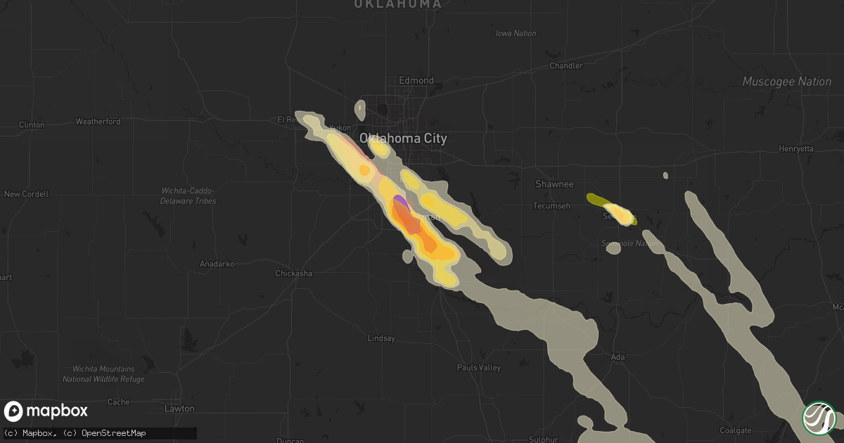
Hail Map in Norman, OK on March 30, 2013
Get this storm
March 30 map
$229
one time, instant access
Download today. No call, no setup
Keep the $229
Bought the map and want the full workflow? Apply the entire $229 to a subscription within 7 days. None of it is wasted.
Every map, not just this one
This buys you this map. Subscription and you get every map we run, in the markets you choose from a few cities to whole states to nationwide. Plus real-time alerts the moment a storm fires.
Contact data
Name, contact info, occupancy, even credit band for addresses in the footprint. You go from where it hit to who to call.
Become the source they trust
Unlimited branding weather history reports on demand. You already have the documented answer ready for the property owner, and you are the one who showed up with it.
Property data and RoofTrace estimates
Pull up any address you have got, its value and the exact code rules for that jurisdiction, straight from One Click Code. Then RoofTrace estimates the squares, pitch, and roof value, priced the way you price.
Storm reports in Norman, OK
Norman, OK
| Date | Description |
|---|---|
| 03/30/20134:05 AM CDT | A local report indicates 1.25 inch wind near 1 SW NORMAN |
| 03/30/20134:00 AM CDT | A local report indicates 60 MPH wind near 2 WSW NORMAN |
| 03/30/20134:00 AM CDT | A local report indicates 1.75 inch wind near 2 SSW NORMAN |
| 03/30/20134:00 AM CDT | Sw 24th and brooks street |
| 03/30/20134:00 AM CDT | Intersection of flood and cruce streets |
| 03/30/20134:00 AM CDT | At the nws forecast office |
| 03/30/20133:55 AM CDT | Nw 36th and main street |
| 03/30/20133:55 AM CDT | Max westheimer airport |
| 03/30/20133:54 AM CDT | A local report indicates 1.25 inch wind near NORMAN |
| 03/30/20133:52 AM CDT | A local report indicates 1.25 inch wind near 4 WNW NORMAN |
All States Impacted by Hail Map on March 30, 2013
All Cities Impacted by Hail Map on March 30, 2013
- Stonewall, LA
- Wayne, OK
- Cordell, OK
- Neosho, MO
- Joplin, MO
- Stigler, OK
- Moundville, MO
- Konawa, OK
- Asher, OK
- Maud, OK
- Rose, OK
- Salina, OK
- Cherokee, KS
- Columbus, KS
- Scammon, KS
- Pittsburg, KS
- Carl Junction, MO
- Girard, KS
- Galena, KS
- Weir, KS
- Locust Grove, OK
- Hulbert, OK
- Peggs, OK
- Foss, OK
- Huntsville, AR
- Kingston, AR
- Garfield, AR
- Eureka Springs, AR
- Frierson, LA
- Gloster, LA
- Noble, OK
- Lexington, OK
- Washington, OK
- Purcell, OK
- Mustang, OK
- Newcastle, OK
- Oklahoma City, OK
- Norman, OK
- Yukon, OK
- Wheatland, OK
- El Reno, OK
- Chelsea, OK
- Nowata, OK
- Kincaid, KS
- Caddo, OK
- Caney, OK
- Bennington, OK
- Lane, OK
- Atoka, OK
- Calera, OK
- Cartwright, OK
- Colbert, OK
- Denison, TX
- Mcalester, OK
- Elkland, MO
- Buffalo, MO
- Stella, MO
- Watson, AR
- Sunflower, MS
- Baird, TX
- Cache, OK
- Fort Scott, KS
- Byars, OK
- Wanette, OK
- Ada, OK
- Stratford, OK
- Linden, TX
- England, AR
- Mountain Ranch, CA
- San Andreas, CA
- Angels Camp, CA
- Murphys, CA
- Vallecito, CA
- Crane, MO
- Aurora, MO
- Ardmore, OK
- Springer, OK
- Graham, OK
- Healdton, OK
- Wilson, OK
- Bethany, OK
- Roff, OK
- Fitzhugh, OK
- Dublin, TX
- Gorman, TX
- De Leon, TX
- Comanche, TX
- Pauls Valley, OK
- Sulphur, OK
- Davis, OK
- Wynnewood, OK
- Hinton, OK
- Lookeba, OK
- Talala, OK
- Oologah, OK
- Claremore, OK
- Stockton, CA
- Dodson, LA
- Sikes, LA
- Lawton, OK
- Indiahoma, OK
- Faxon, OK
- Tupelo, OK
- Adair, OK
- May, TX
- Brownwood, TX
- Foster, OK
- Elmore City, OK
- Kiowa, OK
- Wardville, OK
- Loco, OK
- Gans, OK
- Muldrow, OK
- Sallisaw, OK
- Vian, OK
- Madill, OK
- Williamsburg, KS
- Maysville, OK
- Fort Gibson, OK
- Tahlequah, OK
- Doddsville, MS
- Cleveland, MS
- Gore, OK
- De Kalb, TX
- Flemington, MO
- Holdenville, OK
- Duncan, OK
- Apache, OK
- Elgin, OK
- Colcord, OK
- Burkett, TX
- Piedmont, OK
- Wetumka, OK
- Magazine, AR
- Texarkana, AR
- Wagoner, OK
- Muskogee, OK
- Cassville, MO
- Boswell, OK
- Early, TX
- Blanket, TX
- Cross Plains, TX
- Shreveport, LA
- Grand Cane, LA
- Pleasant Hill, LA
- Mansfield, LA
- Keithville, LA
- Pelican, LA
- Lamar, MO
- Jasper, MO
- Chickasha, OK
- McCune, KS
- Burson, CA
- Campo Seco, CA
- Valley Springs, CA
- Hindsville, AR
- Long Lane, MO
- Conway, MO
- Appleton City, MO
- Rockville, MO
- Butler, MO
- Whitesboro, TX
- Elk City, OK
- Canute, OK
- Avery, TX
- Mangum, OK
- Willow, OK
- Washburn, MO
- Powell, MO
- Freistatt, MO
- Verona, MO
- Monett, MO
- Wentworth, MO
- Pierce City, MO
- Sarcoxie, MO
- Vinita, OK
- Miami, OK
- Wyandotte, OK
- Afton, OK
- Bluejacket, OK
- Fairland, OK
- Centrahoma, OK
- Westphalia, KS
- Garnett, KS
- Welda, KS
- Bronson, KS
- Porter, OK
- Park Hill, OK
- Keota, OK
- Braggs, OK
- Half Way, MO
- Marshfield, MO
- Niangua, MO
- Walnut, KS
- Simms, TX
- Pittsburg, OK
- Kingston, OK
- Kinta, OK
- Seminole, OK
- Lamar, OK
- Dustin, OK
- Ogden, AR
- Marietta, TX
- Naples, TX
- Stonewall, OK
- Milburn, OK
- Comanche, OK
- Cameron, OK
- Jefferson, TX
- Douglassville, TX
- Moran, KS
- Uniontown, KS
- Stuart, OK
- Calvin, OK
- Montrose, MO
- Purdy, MO
- Booneville, AR
- Daisy, OK
- Clayton, OK
- Galena, MO
- Hackett, AR
- McCarley, MS
- Carrollton, MS
- Winona, MS
- Hennepin, OK
- Mokelumne Hill, CA
- Paris, AR
- Granby, MO
- Earlsboro, OK
- Arma, KS
- Belleville, AR
- Danville, AR
- Wewoka, OK
- Carthage, MO
- Redfield, KS
- La Harpe, KS
- Frontenac, KS
- Arcadia, KS
- Cape Fair, MO
- Mount Vernon, MO
- Liberal, MO
- Mulberry, KS
- Mindenmines, MO
- Hepler, KS
- Franklin, KS
- Reeds, MO
- Avilla, MO
- Farlington, KS
- Asbury, MO
- Colony, KS
- Oronogo, MO
- Duncan, MS
- Snow Lake, AR
- Gunnison, MS
- Weaubleau, MO
- Bolivar, MO
- Collins, MO
- Polk, MO
- Pittsburg, MO
- Wheatland, MO
- Coalgate, OK
- Rocky Comfort, MO
- Catoosa, OK
- Cisco, TX
- Mullin, TX
- Gainesville, TX
- Valley View, TX
- West Fork, AR
- Macomb, OK
- Coila, MS
- Blanchard, OK
- Grizzly Flats, CA
- Weleetka, OK
- Okemah, OK
- Bokchito, OK
- Corn, OK
- Hydro, OK
- Tishomingo, OK
- Mill Creek, OK
- Wister, OK
- Little Rock, AR
- Pryor, OK
- Elaine, AR
- Tuttle, OK
- Ratliff City, OK
- Big Cabin, OK
- Seligman, MO
- Dardanelle, AR
- Casa, AR
- Walters, OK
- Bivins, TX
- Rodessa, LA
- Keo, AR
- Scott, AR
- Stuttgart, AR
- Almyra, AR
- Mansfield, AR
- Spiro, OK
- Pocasset, OK
- De Witt, AR
- Prague, OK
- Boley, OK
- Paden, OK
- Blanco, OK
- Quinton, OK
- Adona, AR
- Pottsboro, TX
- Atwood, OK
- Stringtown, OK
- Karnack, TX
- Greenwood, LA
- Marthaville, LA
- Mooringsport, LA
- Heavener, OK
- Howe, OK
- Poteau, OK
- Merigold, MS
- Ashdown, AR
- Clinton, OK
- Erie, KS
- Sadler, TX
- Schlater, MS
- Bunch, OK
- Dill City, OK
- Sasakwa, OK
- Tichnor, AR
- Soper, OK
- Mclean, TX
- Stotts City, MO
- Gillett, AR
- Kingfisher, OK
- Greenwood, AR
- Indianola, OK
- Coweta, OK
- Broken Arrow, OK
- Zephyr, TX
- Sidon, MS
- Greenwood, MS
- Binger, OK
- Anadarko, OK
- Gracemont, OK
- Tuskahoma, OK
- Charleston, AR
- Clarendon, TX
- Humphrey, AR
- Atkins, AR
- Strang, OK
- Antlers, OK
- Lowell, AR
- Rogers, AR
- Newalla, OK
- Waldron, AR
- Houston, AR
- Perryville, AR
- Minco, OK
- Marietta, OK
- Temple, OK
- Amber, OK
- Lebanon, OK
- Watonga, OK
- Sonora, CA
- Lone Grove, OK
- Jonesboro, LA
- Paoli, OK
- Hugo, OK
- West Point, CA
- Pioneer, CA
- Pampa, TX
- Edmond, OK
- Reeds Spring, MO
- Bokoshe, OK
- Red Oak, OK
- Nashoba, OK
- Talihina, OK
- Wapanucka, OK
- Coleman, OK
- Ringling, OK
- Lindsay, OK
- Jay, OK
- Shaw, MS
- Indianola, MS
- Crumrod, AR
- Ethel, AR
- Mellwood, AR
- Mound Bayou, MS
- Shelby, MS
- Tussy, OK
- Ninnekah, OK
- Sutter Creek, CA
- Plymouth, CA
- Ione, CA
- North Carrollton, MS
- Pocola, OK
- Richmond, KS
- Hartford, AR
- Inola, OK
- Branch, AR
- Blue Mound, KS
- Mound City, KS
- Mead, OK
- Carbon, TX
- Rising Star, TX
- Weatherford, OK
- Spavinaw, OK
- Ola, AR
- Hensley, AR
- Garland, KS
- Hartshorne, OK
- Gustine, TX
- Verden, OK
- New Boston, TX
- Geronimo, OK
- Diamond, MO
- Owasso, OK


