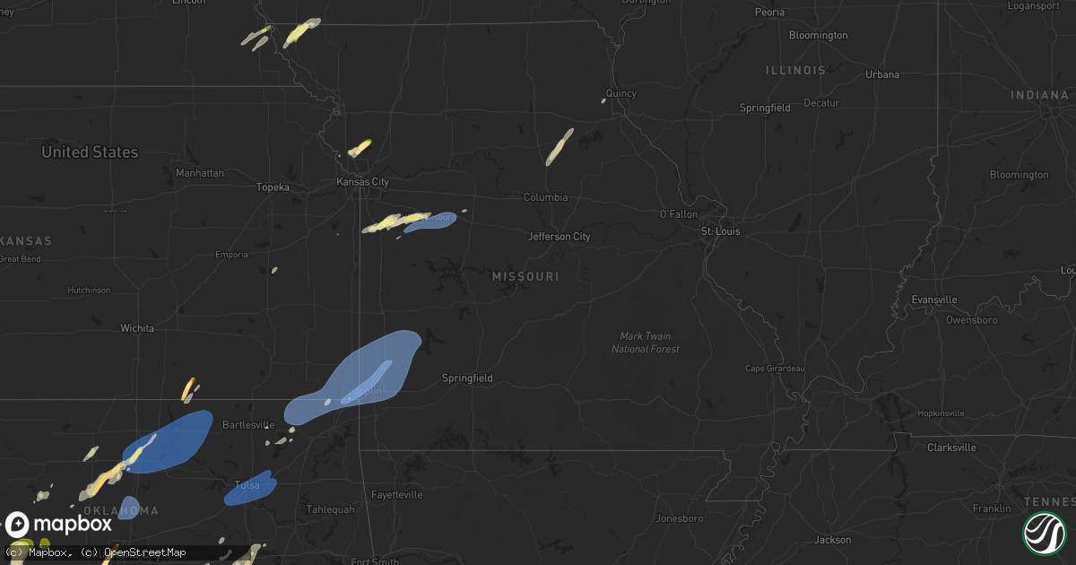
Hail Map in Missouri on March 29, 2025
Get this storm
March 29 map
$229
one time, instant access
Download today. No call, no setup
Keep the $229
Bought the map and want the full workflow? Apply the entire $229 to a subscription within 7 days. None of it is wasted.
Every map, not just this one
This buys you this map. Subscription and you get every map we run, in the markets you choose from a few cities to whole states to nationwide. Plus real-time alerts the moment a storm fires.
Contact data
Name, contact info, occupancy, even credit band for addresses in the footprint. You go from where it hit to who to call.
Become the source they trust
Unlimited branding weather history reports on demand. You already have the documented answer ready for the property owner, and you are the one who showed up with it.
Property data and RoofTrace estimates
Pull up any address you have got, its value and the exact code rules for that jurisdiction, straight from One Click Code. Then RoofTrace estimates the squares, pitch, and roof value, priced the way you price.
Storm reports in Missouri
Missouri
| Date | Description |
|---|---|
| 03/29/20253:29 AM CDT | A local report indicates 61 MPH wind near 1 E Webb City |
| 03/29/20252:31 AM CDT | Reported at joplin regional airport. |
| 03/29/20252:31 AM CDT | A local report indicates 64 MPH wind near 1 W Carterville |
| 03/29/20252:28 AM CDT | A local report indicates 60 MPH wind near 1 NNW Dennis Acres |
| 03/28/202511:44 PM CDT | Time confirmed from radar. |
| 03/28/202511:19 PM CDT | Downed tree and power pole at a residence in holden. Report via social media. Time estimated from radar. |
| 03/28/202511:18 PM CDT | Reports of trees and power lines down in holden. Time estimated from radar. |
| 03/28/202511:15 PM CDT | Several tree limbs down at a residence in holden. Report via social media. Time estimated from radar. |
| 03/28/202511:14 PM CDT | Report via social media. Time estimated from radar. |
| 03/28/202511:08 PM CDT | Pea sized hail as well. |
| 03/28/202510:37 PM CDT | Report via social media. Time estimated from radar. |
| 03/28/202510:37 PM CDT | Report via social media. Time estimated from radar. |
| 03/28/202510:35 PM CDT | A local report indicates 1.00 inch wind near Harrisonville |
| 03/28/202510:35 PM CDT | A local report indicates 1.00 inch wind near Harrisonville |
| 03/28/202510:34 PM CDT | A local report indicates 1.00 inch wind near 1 NNE Harrisonville |
| 03/28/202510:31 PM CDT | A local report indicates 1.00 inch wind near 2 WNW Harrisonville |
| 03/28/202510:03 PM CDT | Report via social media. Time estimated from radar. |
| 03/28/202510:02 PM CDT | Report via social media. Time estimated from radar. |
| 03/28/202510:00 PM CDT | Report via social media. Time estimated from radar. |
| 03/28/202510:00 PM CDT | Report of quarter size hail on social media near 188th street and highway f. Time estimated from radar. |
| 03/28/20259:56 PM CDT | Time confirmed from radar. |
| 03/28/20259:55 PM CDT | Report via social media. Time estimated from radar. |
| 03/28/20259:55 PM CDT | Report from mping: quarter |
| 03/28/20259:07 PM CDT | Report of pea to quarter size hail on the west side of tarkio. Time estimated from radar. |
Cities Impacted by Hail Map on March 29, 2025
- Ranger, TX
- Mingus, TX
- Bangs, TX
- Brownwood, TX
- May, TX
- Ozona, TX
- Gordon, TX
- Rising Star, TX
- Desdemona, TX
- Comanche, TX
- Santo, TX
- Palo Pinto, TX
- Carbon, TX
- Sidney, TX
- Mineral Wells, TX
- Gorman, TX
- Johnson, NE
- Brock, NE
- Randlett, OK
- Peru, NE
- Rock Port, MO
- Nebraska City, NE
- Wichita Falls, TX
- Lipan, TX
- Burlington, KS
- Waverly, KS
- Temple, OK
- Walters, OK
- Burkburnett, TX
- Devol, OK
- Millsap, TX
- De Leon, TX
- Auburn, NE
- Weatherford, TX
- Lawton, OK
- Brownville, NE
- Dublin, TX
- Strawn, TX
- Tarkio, MO
- Westboro, MO
- Duncan, OK
- Marlow, OK
- Brookesmith, TX
- Early, TX
- Vancourt, TX
- Eola, TX
- Stephenville, TX
- Azle, TX
- Bluff Dale, TX
- Clinton, OK
- Butler, OK
- Zephyr, TX
- Blanchard, IA
- Comanche, OK
- Carter, OK
- Rush Springs, OK
- Ninnekah, OK
- Mullin, TX
- Henrietta, TX
- Platte City, MO
- Kansas City, MO
- Elmo, MO
- College Springs, IA
- Coin, IA
- Clarinda, IA
- Braddyville, IA
- Paola, KS
- Gustine, TX
- Blanket, TX
- Lindsay, OK
- Foster, OK
- Chickasha, OK
- Amber, OK
- Hico, TX
- Tuttle, OK
- Enid, OK
- Smithville, MO
- Waurika, OK
- Fletcher, OK
- Ryan, OK
- Edgerton, MO
- Maysville, OK
- Fort Worth, TX
- Trimble, MO
- Haslet, TX
- Plattsburg, MO
- Pauls Valley, OK
- Wayne, OK
- Justin, TX
- Roanoke, TX
- Mustang, OK
- Purcell, OK
- Bradley, OK
- Paoli, OK
- Kremlin, OK
- Alex, OK
- Springtown, TX
- Cleveland, MO
- Elmore City, OK
- Yukon, OK
- Oklahoma City, OK
- Lexington, OK
- Tolar, TX
- Blanchard, OK
- Decatur, TX
- Corn, OK
- Peculiar, MO
- Carlton, TX
- Priddy, TX
- Hamilton, TX
- Cordell, OK
- Freeman, MO
- Ratliff City, OK
- Harrisonville, MO
- Thomas, OK
- Taloga, OK
- Bethany, OK
- Pottsville, TX
- Arapaho, OK
- Weatherford, OK
- Hennessey, OK
- Bison, OK
- Noble, OK
- Hennepin, OK
- Rhome, TX
- Maple City, KS
- Okeene, OK
- Pleasant Hill, MO
- Canton, OK
- Norman, OK
- Kingfisher, OK
- Colony, OK
- Newark, TX
- Iredell, TX
- Glen Rose, TX
- Walnut Springs, TX
- Tecumseh, OK
- Macomb, OK
- Dexter, KS
- Hydro, OK
- Geary, OK
- Hinton, OK
- Douglas, OK
- Marshall, OK
- Fairmont, OK
- Custer City, OK
- Cleburne, TX
- Granbury, TX
- Wanette, OK
- Watonga, OK
- Longdale, OK
- Southard, OK
- Garden City, MO
- East Lynne, MO
- Goldthwaite, TX
- Lewisville, TX
- Flower Mound, TX
- Carnegie, OK
- Argyle, TX
- Byars, OK
- Meridian, TX
- Covington, OK
- Shidler, OK
- Stratford, OK
- Morgan, TX
- Kopperl, TX
- Denton, TX
- The Colony, TX
- Carrollton, TX
- Kingsville, MO
- Holden, MO
- Strasburg, MO
- Godley, TX
- Asher, OK
- Plano, TX
- Frisco, TX
- Cement, OK
- Dover, OK
- Waukomis, OK
- Loyal, OK
- Centerview, MO
- Dallas, TX
- Cranfills Gap, TX
- Mckinney, TX
- Blum, TX
- Richardson, TX
- Cedar Vale, KS
- Tupelo, OK
- Wapanucka, OK
- Calera, OK
- Addison, TX
- Warrensburg, MO
- Garber, OK
- Lucien, OK
- Clifton, TX
- Perry, OK
- Coleman, OK
- Stonewall, OK
- Milburn, OK
- Jonesboro, TX
- Rainbow, TX
- Rio Vista, TX
- Billings, OK
- Wewoka, OK
- Allen, TX
- Atoka, OK
- Grandview, TX
- Seminole, OK
- Durant, OK
- Bokchito, OK
- Ada, OK
- Whitney, TX
- Okemah, OK
- Chilhowee, MO
- Leeton, MO
- Knob Noster, MO
- Red Rock, OK
- Guthrie, OK
- Edmond, OK
- Cashion, OK
- Crescent, OK
- Mulhall, OK
- Coyle, OK
- Wetumka, OK
- Stringtown, OK
- Bennington, OK
- Hillsboro, TX
- Runnells, IA
- Blue Ridge, TX
- Melissa, TX
- Anna, TX
- Holdenville, OK
- Atwood, OK
- Allen, OK
- Midlothian, TX
- Calvin, OK
- Red Oak, TX
- Waxahachie, TX
- Coalgate, OK
- Aquilla, TX
- Abbott, TX
- Princeton, TX
- Ponca City, OK
- Marland, OK
- Lamar, OK
- Dustin, OK
- Ferris, TX
- Lancaster, TX
- Mansfield, TX
- Grand Prairie, TX
- Weleetka, OK
- Boswell, OK
- Bynum, TX
- Milford, TX
- Mertens, TX
- Prairie City, IA
- Mitchellville, IA
- Wilmer, TX
- Newton, IA
- Seagoville, TX
- Forney, TX
- La Monte, MO
- Colfax, IA
- Henryetta, OK
- Frost, TX
- Blooming Grove, TX
- Monroe, IA
- Crandall, TX
- Okmulgee, OK
- Eufaula, OK
- Morris, OK
- Whiteman Air Force Base, MO
- Rockwall, TX
- Hughesville, MO
- Council Hill, OK
- Boynton, OK
- Kaufman, TX
- Scurry, TX
- Terrell, TX
- Royse City, TX
- Quinlan, TX
- Wills Point, TX
- Pawnee, OK
- Morrison, OK
- Talala, OK
- Nowata, OK
- Kellogg, IA
- Kemp, TX
- Tonkawa, OK
- Ralston, OK
- Kaw City, OK
- Fairfax, OK
- Burbank, OK
- Pawhuska, OK
- Point, TX
- Lone Oak, TX
- Mabank, TX
- Vinita, OK
- Chelsea, OK
- Canton, TX
- Tulsa, OK
- Sapulpa, OK
- Glenpool, OK
- Jenks, OK
- Broken Arrow, OK
- Bixby, OK
- Claremore, OK
- Catoosa, OK
- Owasso, OK
- Sand Springs, OK
- Kellyville, OK
- Pryor, OK
- Inola, OK
- Grand Saline, TX
- Miami, OK
- Baxter Springs, KS
- Quitman, TX
- Mineola, TX
- Garvin, OK
- Quapaw, OK
- Welch, OK
- Delaware, OK
- Bluejacket, OK
- Lenapah, OK
- S Coffeyville, OK
- Edna, KS
- Coffeyville, KS
- Chetopa, KS
- Bartlett, KS
- Columbus, KS
- North Miami, OK
- Commerce, OK
- Picher, OK
- Treece, KS
- Cherokee, KS
- Scammon, KS
- West Mineral, KS
- Oswego, KS
- Riverton, KS
- Joplin, MO
- Seneca, MO
- Neosho, MO
- Galena, KS
- Winnsboro, TX
- Broken Bow, OK
- Carl Junction, MO
- Opolis, KS
- Webb City, MO
- Weir, KS
- Frontenac, KS
- Lamar, MO
- Mindenmines, MO
- Oronogo, MO
- Pittsburg, KS
- Asbury, MO
- Carterville, MO
- Liberal, MO
- Purcell, MO
- Jasper, MO
- Neck City, MO
- Granby, MO
- Duenweg, MO
- Alba, MO
- Carthage, MO
- Sarcoxie, MO
- Diamond, MO
- Reeds, MO
- Golden City, MO
- Avilla, MO
- Eagletown, OK
- Heavener, OK
- Sheldon, MO
- Lockwood, MO
- La Russell, MO
- Jerico Springs, MO
- Greenfield, MO
- Arcola, MO
- Stockton, MO
- Grannis, AR
- Wickes, AR
- Watson, OK
- Gillham, AR
- Umpire, AR
- De Queen, AR
- Burkett, TX
- Cross Plains, TX
- Dierks, AR
- Ballinger, TX
- Valley Mills, TX
- Malone, TX
- West, TX
- Dawson, TX
- Hubbard, TX
- Norton, TX
- Penelope, TX
- Tyler, TX
- Flint, TX
- Barry, TX
- Chandler, TX
- Purdon, TX
- Italy, TX
- Richland, TX
- Coleman, TX
- Wortham, TX
- Sturgeon, MO
- Clark, MO
- Holliday, MO
- Madison, MO
- Paris, MO
- Lometa, TX
- Evant, TX
- Lampasas, TX
- Gatesville, TX
- Purmela, TX
- Gladewater, TX
- Waco, TX
- Big Sandy, TX
- Mount Calm, TX
- Axtell, TX
- Coolidge, TX
- Taylor, MO
- Palmyra, MO
- Mexia, TX
- Shawnee, OK


