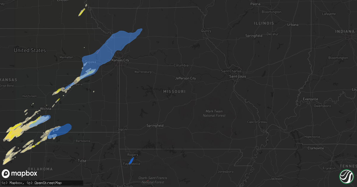
Hail Map in Missouri on March 29, 2022
Get this storm
March 29 map
$229
one time, instant access
Download today. No call, no setup
Keep the $229
Bought the map and want the full workflow? Apply the entire $229 to a subscription within 7 days. None of it is wasted.
Every map, not just this one
This buys you this map. Subscription and you get every map we run, in the markets you choose from a few cities to whole states to nationwide. Plus real-time alerts the moment a storm fires.
Contact data
Name, contact info, occupancy, even credit band for addresses in the footprint. You go from where it hit to who to call.
Become the source they trust
Unlimited branding weather history reports on demand. You already have the documented answer ready for the property owner, and you are the one who showed up with it.
Property data and RoofTrace estimates
Pull up any address you have got, its value and the exact code rules for that jurisdiction, straight from One Click Code. Then RoofTrace estimates the squares, pitch, and roof value, priced the way you price.
Storm reports in Missouri
Missouri
| Date | Description |
|---|---|
| 03/29/20228:51 AM CDT | Delayed report...glass window blown out at the church. |
| 03/29/20224:47 AM CDT | At 947 PM CDT, a severe thunderstorm was located over Gallatin, moving northeast at 55 mph. HAZARD...60 mph wind gusts and penny size hail. SOURCE...Radar indicated. IMPACT...Expect damage to roofs, siding, and trees. Locations impacted include... Chillicothe, Trenton, Gallatin, Jamesport, Gilman City, Pattonsburg, Utica, Spickard, Galt, Chula, Laredo, Coffey, Jameson, Mooresville, Mount Moriah, Tindall, Brimson, Lock Springs and Spring Hill.This includes Interstate 35 in Missouri between mile markers 69 and89. |
| 03/29/20223:47 AM CDT | At 847 PM CDT, severe thunderstorms were located along a line extending from 7 miles northeast of Savannah to Lenexa, moving east at 80 mph. HAZARD...60 mph wind gusts and quarter size hail. SOURCE...Radar indicated. IMPACT...Hail damage to vehicles is expected. Expect wind damage to roofs, siding, and trees. Locations impacted include... Kansas City, Overland Park, Olathe, Independence, Lee's Summit, St. Joseph, Shawnee, Blue Springs, Lenexa, Leawood, Raytown, Liberty, Gladstone, Prairie Village, Grain Valley, Lansing, Excelsior Springs, Merriam, Cameron and Mission.This includes the following highways... Interstate 70 in Missouri between mile markers 0 and 29. Interstate 70 in Kansas between mile markers 410 and 423. Interstate 35 in Missouri between mile markers 0 and 54. Interstate 35 in Kansas between mile markers 220 and 235. Interstate 29 between mile markers 0 and 54. Interstate 635 between mile markers 0 and 12. Interstate 470 between mile markers 0 and 5, and between milemarkers 9 and 16. Interstate 435 between mile markers 0 and 83. Interstate 229 between mile markers 0 and 2. Kansas Turnpike between mile markers 219 and 226. |
| 03/29/20223:08 AM CDT | At 808 PM CDT, severe thunderstorms were located along a line extending from near Lancaster to Clinton, moving northeast at 45 mph. HAZARD...60 mph wind gusts and penny size hail. SOURCE...Radar indicated. IMPACT...Expect damage to roofs, siding, and trees. Locations impacted include... Olathe, Shawnee, Lenexa, Leavenworth, Lansing, Atchison, Bonner Springs, De Soto, Tonganoxie, Platte City, Basehor, Edwardsville, Weston, Lake Quivira, Kansas City, Dearborn, Camden Point, Linwood, Easton and Tracy.This includes the following highways... Interstate 70 in Kansas between mile markers 410 and 413. Interstate 29 between mile markers 16 and 37. Interstate 435 between mile markers 6 and 31. Kansas Turnpike between mile markers 206 and 226. |
| 03/28/20228:54 PM CDT | Nws storm survey found intermittent damage with a small area of ef1 damage to a home. |
| 03/28/20228:51 PM CDT | Corrects previous tstm wnd dmg report from 3 e saint joseph. Delayed report...roof damage to a couple of houses. |
| 03/28/20228:51 PM CDT | Delayed report...roof damage to a couple of houses. |
| 03/28/20228:50 PM CDT | Delayed report...roof damage at east hills mall. |
| 03/28/20228:50 PM CDT | Delayed report...roof damage to east hills mall. |
Cities Impacted by Hail Map on March 29, 2022
- Ord, NE
- Arcadia, NE
- Kiowa, KS
- Burlington, OK
- Alva, OK
- Norwich, KS
- Kremlin, OK
- Throckmorton, TX
- Enid, OK
- Christoval, TX
- Eldorado, TX
- Kechi, KS
- Hamlin, TX
- Roby, TX
- Rotan, TX
- McCaulley, TX
- Aspermont, TX
- Admire, KS
- Overbrook, KS
- Burlingame, KS
- Scranton, KS
- Americus, KS
- Lyndon, KS
- Carbondale, KS
- Reading, KS
- Emporia, KS
- Osage City, KS
- Woodson, TX
- Ninnekah, OK
- Bradley, OK
- Rush Springs, OK
- Barnhart, TX
- San Angelo, TX
- Mertzon, TX
- Big Lake, TX
- Cottonwood Falls, KS
- Matfield Green, KS
- Marlow, OK
- Fletcher, OK
- Lawton, OK
- Arkansas City, KS
- Albany, TX
- Goltry, OK
- Carrier, OK
- Hunter, OK
- Meno, OK
- Pond Creek, OK
- Ringwood, OK
- Lahoma, OK
- Sonora, TX
- Sweetwater, TX
- Merkel, TX
- Nolan, TX
- Trent, TX
- Medicine Lodge, KS
- Hazelton, KS
- Pretty Prairie, KS
- Bronte, TX
- Hardtner, KS
- Geuda Springs, KS
- Medford, OK
- Newkirk, OK
- Braman, OK
- South Haven, KS
- Ponca City, OK
- Dexter, KS
- Lamont, OK
- Blackwell, OK
- Deer Creek, OK
- Nardin, OK
- Winfield, KS
- Rowena, TX
- Sharon, KS
- Amorita, OK
- Attica, KS
- Anthony, KS
- Waldron, KS
- Freeport, KS
- Chester, OK
- Seiling, OK
- Garden Plain, KS
- Viola, KS
- Cheney, KS
- Clearwater, KS
- Wellington, KS
- Coleman, TX
- Gouldbusk, TX
- Bangs, TX
- Santa Anna, TX
- Quanah, TX
- Ballinger, TX
- Purcell, OK
- Talpa, TX
- Litchfield, NE
- Mason City, NE
- Ansley, NE
- Milan, KS
- Argonia, KS
- Belle Plaine, KS
- Conway Springs, KS
- Mulvane, KS
- Mayfield, KS
- Peck, KS
- Bluff City, KS
- Harper, KS
- Danville, KS
- Cherokee, OK
- Caldwell, KS
- Aline, OK
- Fairview, OK
- Waynoka, OK
- Cleo Springs, OK
- Washington, OK
- Blanchard, OK
- Lindsay, OK
- Howells, NE
- Dodge, NE
- Abilene, TX
- Carlsbad, TX
- Harveyville, KS
- Lueders, TX
- Nash, OK
- Towanda, KS
- Clarkson, NE
- Burns, KS
- Peabody, KS
- Florence, KS
- Goddard, KS
- Leigh, NE
- Lexington, OK
- Noble, OK
- Alex, OK
- Haven, KS
- Miles, TX
- Columbus, NE
- Ozona, TX
- Kingman, KS
- Anson, TX
- Hawley, TX
- Cedar Point, KS
- Newton, KS
- Holton, KS
- Rule, TX
- Old Glory, TX
- Maryneal, TX
- Valera, TX
- Voss, TX
- Johnson, NE
- Brock, NE
- Tecumseh, NE
- Isabella, OK
- Nebraska City, NE
- Topeka, KS
- Auburn, KS
- Stamford, TX
- El Dorado, KS
- Schuyler, NE
- Talmage, NE
- Spivey, KS
- Milton, KS
- Wichita, KS
- Andover, KS
- Augusta, KS
- Benton, KS
- Carmen, OK
- Blackwell, TX
- Helena, OK
- Strong City, KS
- Allen, KS
- Elmdale, KS
- Wall, TX
- Eola, TX
- Paint Rock, TX
- Cassoday, KS
- Westphalia, KS
- Le Roy, KS
- Longdale, OK
- Vancourt, TX
- West Point, NE
- Tishomingo, OK
- Mannsville, OK
- Marietta, OK
- Madill, OK
- Mill Creek, OK
- Fayetteville, AR
- Farmington, AR
- Springdale, AR
- Lowell, AR
- Saint Joseph, MO
- Polo, MO
- Winchester, KS
- Bonner Springs, KS
- Wathena, KS
- Dearborn, MO
- Weston, MO
- Kansas City, KS
- Hoyt, KS
- Easton, MO
- Agency, MO
- Smithville, MO
- Silver Lake, KS
- Hamilton, MO
- Stewartsville, MO
- Clarksdale, MO
- Edgerton, MO
- Berryton, KS
- Valley Falls, KS
- Tonganoxie, KS
- Jamesport, MO
- De Kalb, MO
- Kansas City, MO
- Kidder, MO
- Helena, MO
- Delia, KS
- Gallatin, MO
- Lathrop, MO
- Weatherby, MO
- Cummings, KS
- Wakarusa, KS
- Cameron, MO
- Altamont, MO
- Camden Point, MO
- Lecompton, KS
- Osborn, MO
- Amity, MO
- Tecumseh, KS
- Cosby, MO
- Kingston, MO
- Oskaloosa, KS
- Easton, KS
- Trimble, MO
- Turney, MO
- Plattsburg, MO
- Perry, KS
- Farley, MO
- Ozawkie, KS
- Lawrence, KS
- Winston, MO
- Atchison, KS
- Grantville, KS
- Fort Leavenworth, KS
- Elwood, KS
- Platte City, MO
- Basehor, KS
- Linwood, KS
- Maysville, MO
- Gower, MO
- Meriden, KS
- Faucett, MO
- Union Star, MO
- Nortonville, KS
- Waldron, MO
- Quenemo, KS
- McLouth, KS
- Vassar, KS
- Lansing, KS
- Mayetta, KS
- Rossville, KS
- Rushville, MO
- Leavenworth, KS
- Udall, KS
- Shidler, OK
- Cedar Vale, KS
- Maple City, KS
- Kaw City, OK
- Clarksville, AR
- Hartshorne, OK
- Rockwall, TX
- Clarksville, TX


