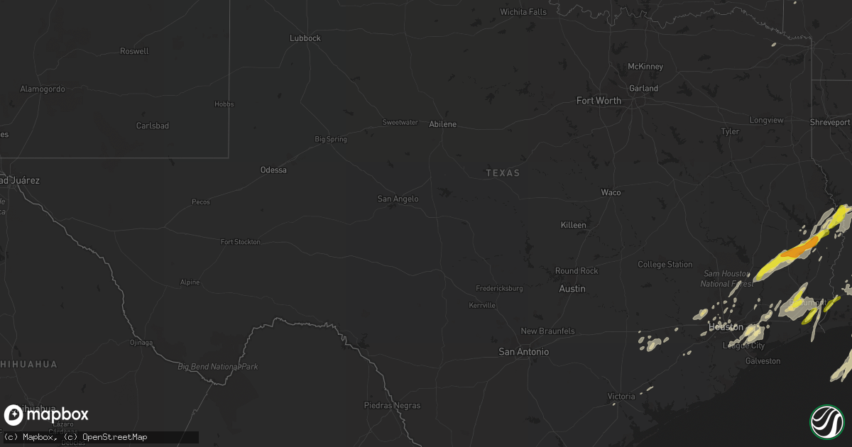
Hail Map in Texas on March 29, 2017
Get this storm
March 29 map
$229
one time, instant access
Download today. No call, no setup
Keep the $229
Bought the map and want the full workflow? Apply the entire $229 to a subscription within 7 days. None of it is wasted.
Every map, not just this one
This buys you this map. Subscription and you get every map we run, in the markets you choose from a few cities to whole states to nationwide. Plus real-time alerts the moment a storm fires.
Contact data
Name, contact info, occupancy, even credit band for addresses in the footprint. You go from where it hit to who to call.
Become the source they trust
Unlimited branding weather history reports on demand. You already have the documented answer ready for the property owner, and you are the one who showed up with it.
Property data and RoofTrace estimates
Pull up any address you have got, its value and the exact code rules for that jurisdiction, straight from One Click Code. Then RoofTrace estimates the squares, pitch, and roof value, priced the way you price.
Storm reports in Texas
Texas
| Date | Description |
|---|---|
| 03/29/20176:37 PM CDT | Brief tornado touchdown and produced damage at an apartment complex. Surveyed by nws crp mic and was rated an ef-1. 50 yard width and 0.27 mile length. |
| 03/29/20176:10 PM CDT | Kbmt relayed a public report of quarter size hail near port neches. |
| 03/29/20176:04 PM CDT | Kbmt relayed a public report of trees down at sul ross and williamsburg in the regina howell area of beaumont. |
| 03/29/20175:20 PM CDT | A local report indicates 1.00 inch wind near PORT ARTHUR |
| 03/29/20175:20 PM CDT | A local report indicates 1.00 inch wind near PORT ACRES |
| 03/29/20175:20 PM CDT | Kbmt reports estimated 60 mph winds on major drive in beaumont. |
| 03/29/20175:17 PM CDT | Public reports quarter size hail in port arthur |
| 03/29/20175:01 PM CDT | Hail mostly dime size with a few quarter size hail |
| 03/29/20174:39 PM CDT | Sheriffs dept reports trees down near farrsville. 88-d displayed tds. |
| 03/29/20174:34 PM CDT | Numerous large trees were uprooted or snapped along hwy 63 west of farrsville. The tornado was on the ground for about 12 miles and ended along us hwy 87 south of mayfl |
| 03/29/20174:12 PM CDT | Several trees were snapped or blown down along fm 1005 near the intersection with us hwy 96 |
| 03/29/20174:10 PM CDT | A local report indicates 1.50 inch wind near JASPER |
| 03/29/20174:08 PM CDT | Sheriffs dept reports trees down on hwy 190. |
| 03/29/20173:35 PM CDT | A brief ef-0 tornado moved across southern chambers county and caused small tree damage. |
| 03/29/20173:35 PM CDT | Damage from a tornado surveyed near dutton lake off kendall road in chambers county rated ef0. Large limbs and trees down in multiple directions along a short path. |
| 03/29/20173:30 PM CDT | Power poles blown over. Fallen trees on house. |
| 03/29/20173:25 PM CDT | Multiple trees were blown down along fm 1013 east of hillister. |
| 03/29/20173:20 PM CDT | Public reported trees and power poles down on county rd 84 via social media. Time estimated from radar. |
| 03/29/20173:15 PM CDT | Sheriffs department reports large tree down across us 69 n. |
| 03/29/20173:13 PM CDT | Tornado touched down on both the north and south sides of lake charmain... Blowing down multiple trees. One home had a tree land on it and a tree landed on a suv. Sever |
| 03/29/20173:12 PM CDT | Roof damage 13100 bay park road... Pasadena. Possible tornado. |
| 03/29/20173:10 PM CDT | Numerous ship cantainers moved and dropped near barbers cut. Possible tornado. |
| 03/29/20173:03 PM CDT | A brief ef-1 tornado moved across la porte and morgans point. Tornado was witnessed to start near the railroad tracks/hwy 146 and it tracked ese across the barbours cut |
| 03/29/20173:01 PM CDT | Many dime size a few quarter size |
| 03/29/20173:00 PM CDT | Nws storm survey found damage from a tornado in la porte. Rating ef-0. |
| 03/29/20173:00 PM CDT | Brief ef-0 tornado moived west to east across la porte and caused considerable tree and power line damage east of hwy 146. |
| 03/29/20172:55 PM CDT | Small ef-1 tornado tracked from the nnw towards the sse and caused damage to some industrial buildings. Tornado winds stacked/pushed cars into and on top of each other |
| 03/29/20171:25 PM CDT | Emergency manager reports large trees down along county road 3740 south of cleveland. |
| 03/29/20171:23 PM CDT | Received a video that showed rapidly changing wind speed and direction as a tornado passed. There was an eye witness that described the funnel. Rated ef0. |
| 03/29/201711:30 AM CDT | Social media report of trees down on 4500 holly street near new castle. Large trees down. Time estimated was around 1130 am. |
| 03/29/201710:35 AM CDT | Collapsed carport and window damage at the azalea place apartments. Possible tornado damage. |
| 03/29/201710:35 AM CDT | Trees down on holly street near newcastle street. |
| 03/29/201710:32 AM CDT | Trees down at braewick and braeswood |
| 03/29/201710:32 AM CDT | Trees downed at braewick drive and s. Braeswood blvd. |
| 03/29/201710:31 AM CDT | A tornado produced mostly ef0 damage... But a few spots near azalea place apartments in southwest houston caused low end ef-1 damage. Start location was along bissonnet |
| 03/29/201710:31 AM CDT | Brief tornado touchdown and produced damage at azalea place apartment complex. Surveyed by nws crp mic and was rated an ef-1. 50 yard width and 0.27 mile length. |
All States Impacted by Hail Map on March 29, 2017
Cities Impacted by Hail Map on March 29, 2017
- Auxvasse, MO
- Lead Hill, AR
- Harrison, AR
- Holts Summit, MO
- Tebbetts, MO
- Jefferson City, MO
- Bonnots Mill, MO
- Fulton, MO
- Mokane, MO
- New Bloomfield, MO
- Kingdom City, MO
- Williamsburg, MO
- Jasper, TX
- Edgerton, KS
- Gardner, KS
- Mammoth Spring, AR
- Edna, TX
- Brookhaven, MS
- Jennings, LA
- Wakarusa, KS
- Olathe, KS
- Dequincy, LA
- Ragley, LA
- Morse, LA
- Lyndon, KS
- Scranton, KS
- Carbondale, KS
- Overbrook, KS
- Sulphur, LA
- Westlake, LA
- Seabrook, TX
- Baytown, TX
- Sumner, MO
- Hale, MO
- Chillicothe, MO
- Purdin, MO
- Triplett, MO
- Meadville, MO
- Linneus, MO
- Laclede, MO
- Kaplan, LA
- Beaumont, TX
- Hockley, TX
- Katy, TX
- Cypress, TX
- Houston, TX
- Opelousas, LA
- Grand Chenier, LA
- Creole, LA
- Cameron, LA
- Kingwood, TX
- Humble, TX
- Thayer, MO
- Lake Charles, LA
- Iowa, LA
- Crowley, LA
- Elton, LA
- Roanoke, LA
- Iota, LA
- Evangeline, LA
- Lacassine, LA
- Eunice, LA
- Welsh, LA
- Basile, LA
- Bell City, LA
- Lake Arthur, LA
- Kinder, LA
- Woodville, TX
- Berryton, KS
- Topeka, KS
- Vinton, LA
- Youngsville, LA
- Abbeville, LA
- Maurice, LA
- Lafayette, LA
- Broussard, LA
- Breaux Bridge, LA
- Saint Martinville, LA
- Monroe City, MO
- Cabool, MO
- Everton, AR
- Eagle Lake, TX
- New Iberia, LA
- Hillister, TX
- Wiergate, TX
- Livingston, TX
- Cleveland, TX
- Warren, TX
- Hornbeck, LA
- Brookeland, TX
- Burkeville, TX
- Evans, LA
- Kirbyville, TX
- Fred, TX
- Hemphill, TX
- Florien, LA
- Anacoco, LA
- Saratoga, TX
- Leesville, LA
- Kountze, TX
- Spurger, TX
- Newton, TX
- Garwood, TX
- Columbus, TX
- Franklin, LA
- Meta, MO
- Koeltztown, MO
- Loose Creek, MO
- Freeburg, MO
- Westphalia, MO
- Argyle, MO
- Devers, TX
- Liberty, TX
- Hull, TX
- Eugene, MO
- Stoutland, MO
- Richland, MO
- Damascus, AR
- Center Ridge, AR
- Morrilton, AR
- Greenbrier, AR
- Plumerville, AR
- Springfield, AR
- Brinktown, MO
- Port Arthur, TX
- Pasadena, TX
- La Porte, TX
- Dayton, TX
- Elk Creek, MO
- Lebanon, MO
- Kaiser, MO
- Osage Beach, MO
- Tunas, MO
- Lohman, MO
- Russellville, MO
- Montreal, MO
- Eldridge, MO
- Linn Creek, MO
- Tuscumbia, MO
- Sunrise Beach, MO
- Eldon, MO
- Lake Ozark, MO
- Hartsburg, MO
- Camdenton, MO
- Olean, MO
- Henley, MO
- Montgomery City, MO
- Hallettsville, TX
- Woodville, MS
- Sunset, LA
- Wharton, TX
- Orange, TX
- Bridge City, TX
- Waverly, MO
- Norborne, MO
- Carrollton, MO
- Kansas City, KS
- Norman, AR
- Perry, MO
- Santa Fe, MO
- Palmyra, MO
- Philadelphia, MO
- Stoutsville, MO
- Anahuac, TX
- Scott, LA
- Duson, LA
- Bee Branch, AR
- Quitman, AR
- Patterson, LA
- Delhi, LA
- Weimar, TX
- Theodosia, MO
- Protem, MO
- Rayne, LA
- Galena Park, TX
- Port Neches, TX
- Nederland, TX
- Horseshoe Bend, AR
- Violet Hill, AR
- Browning, MO
- Bosworth, MO
- China, TX
- Hamshire, TX
- Nome, TX
- Sour Lake, TX
- Buna, TX
- Vidor, TX
- Winnie, TX
- Groves, TX
- Lumberton, TX
- Silsbee, TX
- Spring Hill, KS
- Birch Tree, MO
- Alton, MO
- Louisiana, MO
- Rockport, IL
- Splendora, TX
- Porter, TX
- Conroe, TX
- New Caney, TX
- Wiseman, AR
- Franklin, AR
- Pearland, TX
- Jessieville, AR
- Oberlin, LA
- Victoria, TX
- Danville, AR
- Church Point, LA
- Barry, IL
- Gueydan, LA
- Spring, TX
- Claremore, OK
- Ash Flat, AR
- Brockwell, AR
- Melbourne, AR
- Hannibal, MO
- Quincy, IL
- Payson, IL
- Pioneer, LA
- Epps, LA
- Prim, AR
- Drasco, AR
- Mountain View, AR
- Lumberton, MS
- Gloster, MS
- Wallisville, TX
- Egan, LA
- Carencro, LA
- Meadville, MS
- Natchez, MS
- Fairfield Bay, AR
- Shirley, AR
- Delcambre, LA
- Erath, LA
- Vidalia, LA
- Clifton Hill, MO
- Salisbury, MO
- Needville, TX
- Beasley, TX
- Thornfield, MO
- Squires, MO
- Alleyton, TX
- Jeanerette, LA
- Branch, LA
- Vanzant, MO
- Mountain Grove, MO
- Ganado, TX
- Brumley, MO
- De Queen, AR
- Wallis, TX
- Sealy, TX
- Missouri City, TX
- Brookfield, MO
- Caddo Gap, AR
- Loreauville, LA
- Chamois, MO
- Drury, MO
- Norwood, MO
- Provencal, LA
- Dixon, MO
- Wasola, MO
- Ava, MO
- Higden, AR
- Edgemont, AR
- McCall Creek, MS
- Lolita, TX
- Mora, LA
- De Kalb, TX
- Portland, MO
- Clinton, AR
- Webster, TX
- League City, TX
- Alvin, TX
- Kemah, TX
- Friendswood, TX
- Lena, LA
- Flatwoods, LA
- Shepherd, TX
- Ulman, MO
- Rayville, LA
- Grosse Tete, LA
- Maringouin, LA
- Catoosa, OK
- Niangua, MO
- Conway, MO
- Windyville, MO
- Grovespring, MO
- Sugar Land, TX
- Richmond, TX
- Hackberry, LA
- Many, LA
- La Grange, MO
- Martinsburg, MO
- Mexico, MO
- Laddonia, MO
- Rush Hill, MO
- Benton City, MO
- Durham, MO
- Maywood, MO
- Hughesville, MO
- Houstonia, MO
- Miami, MO
- De Witt, MO
- Malta Bend, MO
- Grain Valley, MO
- Lees Summit, MO
- Solo, MO
- Willow Springs, MO
- Houston, MO
- Elmer, MO
- La Plata, MO
- New Cambria, MO
- Atlanta, MO
- Kirksville, MO
- Ethel, MO
- Callao, MO
- Bowling Green, MO
- Chelsea, OK
- Tulsa, OK
- Lenexa, KS
- De Soto, KS
- Shawnee, KS
- Belleville, AR
- Delaware, AR
- New Blaine, AR
- Havana, AR
- Dardanelle, AR
- Dover, AR
- Pelsor, AR
- Royal, AR
- Mountain Pine, AR
- Yellville, AR
- Mountain Home, AR
- Norfork, AR
- Cherokee Village, AR


