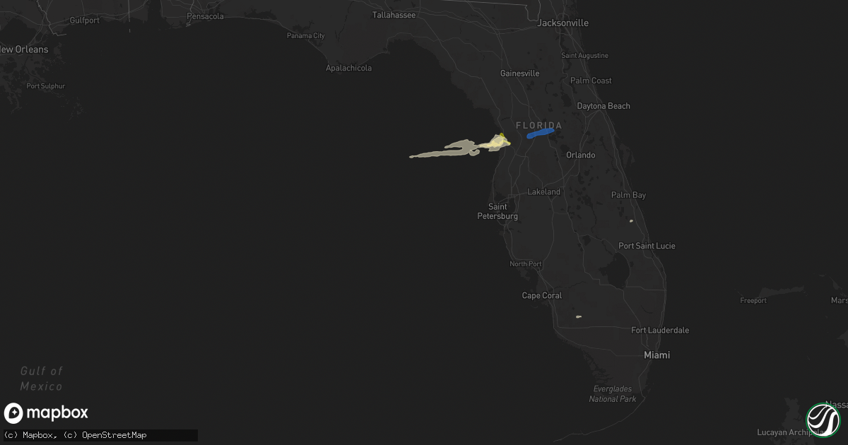
Hail Map in Florida on March 29, 2014
Get this storm
March 29 map
$229
one time, instant access
Download today. No call, no setup
Keep the $229
Bought the map and want the full workflow? Apply the entire $229 to a subscription within 7 days. None of it is wasted.
Every map, not just this one
This buys you this map. Subscription and you get every map we run, in the markets you choose from a few cities to whole states to nationwide. Plus real-time alerts the moment a storm fires.
Contact data
Name, contact info, occupancy, even credit band for addresses in the footprint. You go from where it hit to who to call.
Become the source they trust
Unlimited branding weather history reports on demand. You already have the documented answer ready for the property owner, and you are the one who showed up with it.
Property data and RoofTrace estimates
Pull up any address you have got, its value and the exact code rules for that jurisdiction, straight from One Click Code. Then RoofTrace estimates the squares, pitch, and roof value, priced the way you price.
Storm reports in Florida
Florida
| Date | Description |
|---|---|
| 03/29/20145:10 PM CDT | Branches and signs down at the intersection of jog road and hypoluxo |
| 03/29/20145:00 PM CDT | Playhouse blown to pieces across yard and fan blades blown off outside porch. Report relayed via social media. |
| 03/29/20144:40 PM CDT | Shingles ripped off roof. 30-foot royal palm tree uprooted. Another royal palm tree broke in half. |
| 03/29/20142:15 PM CDT | Broadcast media relayed a photo of damage to a metal roof on a mobile home in the lakewood village subdivision in melbourne. Time estimated via radar. |
| 03/29/20142:15 PM CDT | Power lines down on palm bay road west of i-95. Time estimated by radar. |
| 03/29/20141:28 PM CDT | Several public reports of hail in sanford up to the size of half dollars. Reports via social media. |
| 03/29/20141:20 PM CDT | Orange county emergency management reports possible tornado damage in the isle of pines subdivision near lake mary jane. Multiple trees were downed... Some on homes and s (ml |
| 03/29/20141:20 PM CDT | Nws survey extended from narcoosee road near eagle creek golf club to moss park and east of lake mary jane. To the west of lake mary jane straight line wind damage est. |
| 03/29/20141:15 PM CDT | Fence damage in tuscany preserve |
| 03/29/201412:45 PM CDT | Oak tree uprooted in palm harbor. |
| 03/29/201412:02 PM CDT | Power lines down on state road 50 between mariner and highpoint. |
| 03/29/201412:02 PM CDT | Power lines down on magnolia drive in fruitland park. Time estimated from radar. |
| 03/29/201411:35 AM CDT | General public report 60 - 70 mph winds in thunderstorm. |
| 03/29/201411:35 AM CDT | Public reported quarter sized hail with thunderstorm 1 mile sw of wildwood. |
| 03/29/201411:20 AM CDT | Two trees down in floral city on east sandpiper road and east golber. |
| 03/29/201411:18 AM CDT | Tree down at residence on east perry street in inverness. |
| 03/29/201410:55 AM CDT | Power lines down on state road 50 between mariner and highpoint. Time estimated by radar. |
| 03/29/201410:55 AM CDT | Tree down over east stage coach road 2 miles from hwy 491. |
| 03/29/201410:45 AM CDT | 911 dispatch reports a tree downed by strong wind gusts on tanner road in the vicinity of florahome. Time of damage based on radar data. |
| 03/29/201410:40 AM CDT | Broadcast media relayed report of a tree down across shoal line road and cortez blvd. |
| 03/29/201410:15 AM CDT | 911 dispatch reports a tree downed by strong wind gusts at the intersection of sw williston road and sw wacahoota road. Time of damage based on radar data |


