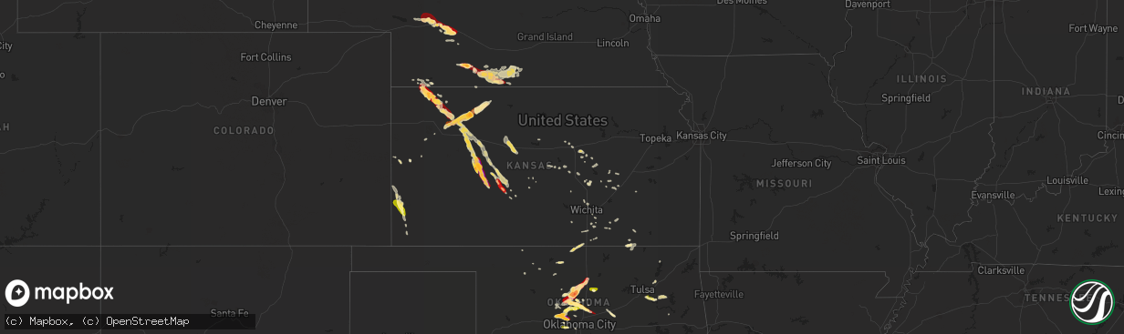
Hail Map in Kansas on March 29, 2013
The weather event in Kansas on March 29, 2013 includes Hail map. 4 states and 271 cities were impacted and suffered possible damage. The total estimated number of properties impacted is 2,542.
Want more than just the map?
Turn this storm into a full workflow.
- Owner + property data so you know who to knock
- OnDemand branded weather history reports to win the "did we even have hail?" argument
- RoofTrace estimate so reps stop guessing numbers at the door
Bought this map? Upgrade within 7 days and we'll credit the $230. (10-15 min setup call)
Hail
2,542
Estimated number of impacted properties by a 1.00" hail or larger5,509
Estimated number of impacted properties by a 1.75" hail or larger2,539
Estimated number of impacted properties by a 2.50" hail or largerStorm reports in Kansas
Kansas
| Date | Description |
|---|---|
| 03/29/20132:30 AM CDT | Nickel sized melting hailstones were still on the ground early saturday morning. |
| 03/29/20132:00 AM CDT | Most of the hail was smaller. |
| 03/29/20131:45 AM CDT | Hail was reported from nickle to quarter sized and they had 0.16 inches of rain. |
| 03/29/20131:20 AM CDT | Hail from nickels to quarters was reported. |
| 03/29/201312:40 AM CDT | A local report indicates 1.00 inch wind near 6 NNE BROWNELL |
| 03/28/201310:07 PM CDT | A local report indicates 1.00 inch wind near 6 N ROLLA |
| 03/28/201310:07 PM CDT | A local report indicates 1.00 inch wind near 7 ENE HUGOTON |
| 03/28/20139:39 PM CDT | Report via the ping project |
| 03/28/20139:25 PM CDT | Hail completely covered the ground |
| 03/28/20139:05 PM CDT | A local report indicates 1.00 inch wind near JOHNSON CITY |
| 03/28/20139:02 PM CDT | Estimated a few golf ball size hail stones |
| 03/28/20138:54 PM CDT | A local report indicates 1.50 inch wind near 9 SSE ATWOOD |
| 03/28/20138:54 PM CDT | Mostly 3/4 to 1 inch covering the ground |
| 03/28/20138:45 PM CDT | A local report indicates 1.00 inch wind near 3 N JOHNSON CITY |
| 03/28/20138:38 PM CDT | Roads covered in hail |
| 03/28/20138:35 PM CDT | Ground nearly covered in hail |
| 03/28/20138:25 PM CDT | Nickel to golf ball size hail completely covering ground |
| 03/28/20138:10 PM CDT | A local report indicates 1.00 inch wind near 13 N JOHNSON CITY |
Cities Impacted by Hail Map on March 29, 2013
- Walton, KS
- Newton, KS
- Leoti, KS
- Winona, KS
- Tribune, KS
- Hill City, KS
- Lenora, KS
- Weatherford, TX
- Fort Worth, TX
- Aledo, TX
- Naval Air Station Jrb, TX
- Godley, TX
- Crowley, TX
- Rush Springs, OK
- Eustis, NE
- Stockville, NE
- Moorefield, NE
- Abilene, KS
- Gypsum, KS
- Cashion, OK
- Guthrie, OK
- Upland, NE
- Stillwater, OK
- Roff, OK
- Syracuse, KS
- Quinter, KS
- Chandler, OK
- Sparks, OK
- Stroud, OK
- Atwood, KS
- Wakeeney, KS
- Ellis, KS
- Brownell, KS
- Ogallah, KS
- Pond Creek, OK
- Nash, OK
- Randlett, OK
- Burkburnett, TX
- Devol, OK
- Coweta, OK
- Wagoner, OK
- Orlando, OK
- Covington, OK
- Hennessey, OK
- Lucien, OK
- Marshall, OK
- Crescent, OK
- Perry, OK
- Byers, TX
- Ryan, OK
- Wichita Falls, TX
- Petrolia, TX
- Coleman, TX
- Talpa, TX
- Tupelo, OK
- Stonewall, OK
- Wapanucka, OK
- Sutherland, NE
- Hershey, NE
- Paxton, NE
- Victoria, KS
- Edmond, OK
- Medford, OK
- Caldwell, KS
- South Haven, KS
- Kingfisher, OK
- North Platte, NE
- Maxwell, NE
- Hays, KS
- Curtis, NE
- Wellfleet, NE
- Geneseo, KS
- Alva, OK
- Oberlin, KS
- Dickens, TX
- Post, TX
- Crosbyton, TX
- Holbrook, NE
- Cambridge, NE
- Walker, KS
- Gorham, KS
- McDonald, KS
- Johnson, KS
- Richfield, KS
- Republican City, NE
- Hildreth, NE
- Alma, NE
- Naponee, NE
- Wilcox, NE
- Orleans, NE
- Yukon, OK
- Mustang, OK
- Cement, OK
- Ninnekah, OK
- Muskogee, OK
- Broken Arrow, OK
- Collyer, KS
- Tescott, KS
- Trenton, NE
- Bixby, OK
- Bartley, NE
- Claremore, OK
- El Reno, OK
- Salina, KS
- Lahoma, OK
- Meno, OK
- Selden, KS
- Colby, KS
- Sweetwater, TX
- Mulvane, KS
- Belle Plaine, KS
- Burdett, KS
- Pawhuska, OK
- Cedar Vale, KS
- Sedan, KS
- Oakley, KS
- Rexford, KS
- Utica, KS
- Ransom, KS
- Morland, KS
- Hanston, KS
- Ness City, KS
- Hoxie, KS
- Jetmore, KS
- Arnold, KS
- Catoosa, OK
- Owasso, OK
- Haskell, TX
- Stratton, NE
- Ralls, TX
- Lorenzo, TX
- Arkansas City, KS
- Goessel, KS
- Loveland, OK
- Quitaque, TX
- Stamford, NE
- Lewis, KS
- Hope, KS
- Lockney, TX
- Turkey, TX
- Floydada, TX
- Calumet, OK
- Piedmont, OK
- Okarche, OK
- Beaver City, NE
- Bloomington, NE
- Oxford, NE
- Holdrege, NE
- Edison, NE
- Arapahoe, NE
- Norton, KS
- Kinsley, KS
- Garfield, KS
- Larned, KS
- Moundridge, KS
- Geuda Springs, KS
- Tulsa, OK
- Alexander, KS
- Nekoma, KS
- Iowa Park, TX
- Lane, OK
- Rozel, KS
- Udall, KS
- Marquette, KS
- Max, NE
- Galva, KS
- Hollister, OK
- Frederick, OK
- Chickasha, OK
- Atoka, OK
- Burrton, KS
- Latham, KS
- Atlanta, KS
- Bazine, KS
- Benkelman, NE
- Loraine, TX
- St John, KS
- Coalgate, OK
- Centrahoma, OK
- Matfield Green, KS
- Joshua, TX
- Rule, TX
- Rochester, TX
- Mcpherson, KS
- Kechi, KS
- Wichita, KS
- Dover, OK
- Arcadia, OK
- Mulhall, OK
- Luther, OK
- Wynnewood, OK
- Derby, KS
- Cassoday, KS
- Herndon, KS
- Peabody, KS
- Electra, TX
- Wellington, KS
- Silverton, TX
- Oklahoma City, OK
- Florence, KS
- Hudson, KS
- Davenport, OK
- Purcell, OK
- Blanchard, OK
- Cedar Point, KS
- Chester, OK
- Valley Center, KS
- Rose Hill, KS
- Ballinger, TX
- Winters, TX
- Nowata, OK
- Snyder, TX
- Ellinwood, KS
- Belpre, KS
- Bradley, OK
- Vernon, TX
- Breckenridge, TX
- Sylvan Grove, KS
- Lucas, KS
- Milburn, OK
- Stamford, TX
- Little River, KS
- Strawn, TX
- Colorado City, TX
- Union City, OK
- Cottonwood Falls, KS
- Elmdale, KS
- Roscoe, TX
- Hamilton, KS
- Amber, OK
- Alex, OK
- Burns, KS
- Conway Springs, KS
- Monument, KS
- Ramona, KS
- Tampa, KS
- Peru, KS
- Chautauqua, KS
- Davis, OK
- Wayne, OK
- Rush Center, KS
- Burden, KS
- Winfield, KS
- Bertrand, NE
- Maysville, OK
- Prague, OK
- Great Bend, KS
- Marion, KS
- Durham, KS
- Anadarko, OK
- Gracemont, OK
- Aline, OK
- Carmen, OK
- Dacoma, OK
- Mansfield, TX
- Milton, KS
- Slaton, TX
- Stringtown, OK
- Aspermont, TX
- Ada, OK
- Crowell, TX
- Petersburg, TX
- Strong City, KS
- Flomot, TX
- Matador, TX
- Mcadoo, TX
- Verden, OK
- Brady, NE
- Wellston, OK
- Manter, KS
- Novice, TX


