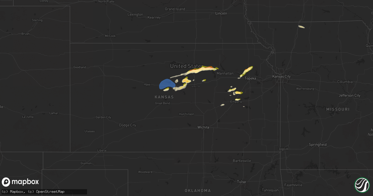
Hail Map in Kansas on March 27, 2025
Get this storm
March 27 map
$229
one time, instant access
Download today. No call, no setup
Keep the $229
Bought the map and want the full workflow? Apply the entire $229 to a subscription within 7 days. None of it is wasted.
Every map, not just this one
This buys you this map. Subscription and you get every map we run, in the markets you choose from a few cities to whole states to nationwide. Plus real-time alerts the moment a storm fires.
Contact data
Name, contact info, occupancy, even credit band for addresses in the footprint. You go from where it hit to who to call.
Become the source they trust
Unlimited branding weather history reports on demand. You already have the documented answer ready for the property owner, and you are the one who showed up with it.
Property data and RoofTrace estimates
Pull up any address you have got, its value and the exact code rules for that jurisdiction, straight from One Click Code. Then RoofTrace estimates the squares, pitch, and roof value, priced the way you price.
Storm reports in Kansas
Kansas
| Date | Description |
|---|---|
| 03/27/20256:44 PM CDT | A local report indicates 1.00 inch wind near 5.5 S Dorrance |
| 03/27/20256:40 PM CDT | A local report indicates 1.50 inch wind near 3 NW Oak Hill |
| 03/27/20256:40 PM CDT | A local report indicates 1.50 inch wind near 3 S Miltonvale |
| 03/27/20256:25 PM CDT | Vehicles dented. |
| 03/27/20256:20 PM CDT | Second round of golf ball sized hail and 45-55 mph wind located within the city of beverly... Lincoln county. |
| 03/27/20256:06 PM CDT | A local report indicates 1.75 inch wind near Beverly |
| 03/27/20255:06 PM CDT | Reported at stanton county muni airport. |
| 03/27/20255:00 PM CDT | Mesonet station bnkku bunker hill 3ne. |
| 03/27/202510:24 AM CDT | A few quarter-sized hailstones with a lot of 0.5 inch hailstones. |
| 03/27/202510:15 AM CDT | Hail covered the ground. |
| 03/27/20259:54 AM CDT | A local report indicates 1.25 inch wind near 2 E Admire |
| 03/27/20259:54 AM CDT | Relayed by kvoe radio. Time estimated from radar data. |
| 03/27/20259:54 AM CDT | Relayed by kvoe radio. Time estimated from radar data. |
| 03/27/20259:47 AM CDT | Hail covered the ground. |
| 03/27/20259:47 AM CDT | Relayed photo from northern heights high school of quarter to half dollar size hail covering the ground. |
| 03/27/20259:45 AM CDT | Pictures sent via slack. |
| 03/27/20259:35 AM CDT | A local report indicates 1.00 inch wind near Rossville |
| 03/27/20258:02 AM CDT | Kemp. |
All States Impacted by Hail Map on March 27, 2025
Cities Impacted by Hail Map on March 27, 2025
- Nodaway, IA
- Villisca, IA
- Corning, IA
- Gravity, IA
- Lenox, IA
- Sharpsburg, IA
- Bedford, IA
- Eagleville, MO
- Elmdale, KS
- Cainsville, MO
- Ridgeway, MO
- Blythedale, MO
- Cottonwood Falls, KS
- Council Grove, KS
- Allen, KS
- Alta Vista, KS
- Alma, KS
- Maple Hill, KS
- Paxico, KS
- Rossville, KS
- Topeka, KS
- Americus, KS
- Emporia, KS
- Admire, KS
- Reading, KS
- Silver Lake, KS
- Delia, KS
- Mayetta, KS
- Hoyt, KS
- Denison, KS
- Burlington, KS
- Hartford, KS
- Linn, TX
- Santa Elena, TX
- San Isidro, TX
- Delmita, TX
- Edinburg, TX
- Encino, TX
- Armstrong, TX
- Hargill, TX
- Raymondville, TX
- San Perlita, TX
- Grulla, TX
- Rio Grande City, TX
- Sullivan City, TX
- Mission, TX
- La Joya, TX
- Mcallen, TX
- Penitas, TX
- Hidalgo, TX
- Pharr, TX
- Alamo, TX
- San Juan, TX
- Donna, TX
- Edcouch, TX
- Weslaco, TX
- Elsa, TX
- Mercedes, TX
- La Villa, TX
- Harlingen, TX
- Santa Rosa, TX
- Progreso, TX
- Alpine, TX
- La Feria, TX
- Lyford, TX
- Combes, TX
- Sebastian, TX
- Sylvan Grove, KS
- Pendleton, OR
- Meacham, OR
- Lincoln, KS
- Bunker Hill, KS
- Russell, KS
- Dorrance, KS
- Luray, KS
- Lucas, KS
- Wilson, KS
- Barnard, KS
- Ellsworth, KS
- Minneapolis, KS
- Beverly, KS
- Delphos, KS
- Tescott, KS
- Glasco, KS
- San Benito, TX
- Miltonvale, KS
- Hoisington, KS
- Clay Center, KS
- Kanopolis, KS
- Brookville, KS
- Salina, KS
- Rio Hondo, TX
- Riley, KS
- Leonardville, KS
- Solomon, KS
- Abilene, KS
- Laredo, TX
- Los Fresnos, TX
- San Ygnacio, TX
- Oilton, TX
- Mirando City, TX
- Princeton, MO
- Eskridge, KS
- Brownsville, TX
- Olmito, TX
- Decorah, IA
- Oakville, IA
- Oquawka, IL
- Seaton, IL
- Bricelyn, MN
- Oregon, IL
- Kiester, MN
- Wells, MN
- Waukon, IA
- Prairie Du Chien, WI
- Wauzeka, WI
- Rewey, WI
- Chester, IA
- Alexis, IL
- Aledo, IL
- Woodman, WI
- Fennimore, WI
- Mount Hope, WI
- Alden, MN
- Little York, IL
- Boscobel, WI
- Le Roy, MN
- Viola, IL
- Gays Mills, WI
- Blue River, WI
- Linden, WI
- Mineral Point, WI
- Albert Lea, MN
- Livingston, WI
- Hollandale, WI
- Dodgeville, WI
- Barneveld, WI
- La Crescent, MN
- Houston, MN
- Browntown, WI
- Lime Springs, IA
- Harmony, MN
- Reynolds, IL
- Hartland, MN
- New Richland, MN
- Mount Horeb, WI
- Ellendale, MN
- Matherville, IL
- Sherrard, IL
- Preston, MN
- Monroe, WI
- La Crosse, WI
- Muscoda, WI
- New Windsor, IL
- Belleville, WI
- Blue Mounds, WI
- Racine, MN
- Stewartville, MN
- Verona, WI
- Cashton, WI
- Winnebago, IL
- Pecatonica, IL
- Lanesboro, MN
- Canton, MN
- Orion, IL
- Lynn Center, IL
- Milan, IL
- Albany, WI
- Monticello, WI
- Norwalk, WI
- Rockland, WI
- Ontario, WI
- Mabel, MN
- Spring Grove, MN
- Brooklyn, WI
- Evansville, WI
- Oregon, WI
- Stoughton, WI
- Caledonia, MN
- Winona, MN
- Edgerton, WI
- South Padre Island, TX
- Cottage Grove, WI
- Cambridge, WI
- Deerfield, WI
- Spring Valley, MN
- Peterson, MN
- Fountain, MN
- Chatfield, MN
- Hokah, MN


