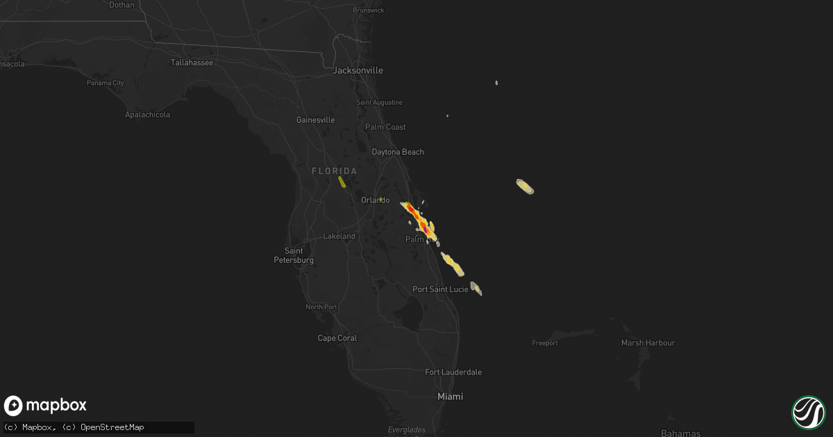
Hail Map on March 27, 2019
Get this storm
March 27 map
$229
one time, instant access
Download today. No call, no setup
Keep the $229
Bought the map and want the full workflow? Apply the entire $229 to a subscription within 7 days. None of it is wasted.
Every map, not just this one
This buys you this map. Subscription and you get every map we run, in the markets you choose from a few cities to whole states to nationwide. Plus real-time alerts the moment a storm fires.
Contact data
Name, contact info, occupancy, even credit band for addresses in the footprint. You go from where it hit to who to call.
Become the source they trust
Unlimited branding weather history reports on demand. You already have the documented answer ready for the property owner, and you are the one who showed up with it.
Property data and RoofTrace estimates
Pull up any address you have got, its value and the exact code rules for that jurisdiction, straight from One Click Code. Then RoofTrace estimates the squares, pitch, and roof value, priced the way you price.
Storm reports
Texas
| Date | Description |
|---|---|
| 03/27/20192:34 AM CDT | At 733 PM CDT, a severe thunderstorm was located near Waka, or 12 miles east of Spearman, moving northeast at 15 mph. HAZARD...60 mph wind gusts and quarter size hail. SOURCE...Radar indicated. IMPACT...Minor damage to roofs, siding, and trees is possible. Hail damage to vehicles is expected. Locations impacted include... Perryton, Waka and Farnsworth. |
| 03/26/20198:13 PM CDT | Storm chaser reported mostly nickel but some slightly larger hail at the corner of the 70 and 83 intersection about 7 miles south of perryton. |
| 03/26/20197:35 PM CDT | A local report indicates 1.00 inch wind near 2 WSW FARNSWORTH |
| 03/26/20197:28 PM CDT | Storm chaser sent in a picture of hail the size of a quarter. |
Florida
| Date | Description |
|---|---|
| 03/27/20198:54 AM CDT | A local report indicates 1.00 inch wind near INDIAN HARBOUR BEACH |
| 03/27/20198:51 AM CDT | A local report indicates 1.75 inch wind near SATELLITE BEACH |
| 03/27/20198:45 AM CDT | Correction to earlier report. Near 1753 a1a satellite beach. |
| 03/27/20198:45 AM CDT | Severe storm produced a large amount of damaging hail. Duration was 10 minutes and a photo of the largest stones next to a measuring tape was provided. |
| 03/27/20198:40 AM CDT | One inch hail reported near kelly park in merritt island. |
| 03/27/20198:20 AM CDT | Quarter size hail in river woods subdivision in south rockledge near indian river. |
| 03/27/20198:10 AM CDT | Numerous reports of quarter to golf ball size hail in river woods subdivision in south rockledge near the indian river. Hail reported between 910-923 am. |
| 03/27/20198:10 AM CDT | Hail up to ping pong ball size 910 am to 920 am in south rockledge/viera. |
| 03/27/20198:04 AM CDT | A local report indicates 1.00 inch wind near 6 WSW CAPE CANAVERAL |
| 03/27/20198:03 AM CDT | Quarter size hail at brevard co eoc in rockledge. |
| 03/27/20198:00 AM CDT | Hail up to golf ball size off range road in cocoa. |
| 03/27/20197:59 AM CDT | Hail up to an inch in cocoa. |
| 03/27/20197:55 AM CDT | Hail up to golf ball size in cocoa. |
| 03/27/20197:52 AM CDT | A local report indicates 1.00 inch wind near 2 WSW COCOA |
| 03/27/20197:36 AM CDT | Hail up to 1-1.5 inches in diameter reported in the canaveral groves area. |
| 03/27/20195:11 AM CDT | At 1011 AM EDT, a severe thunderstorm was located over Rockledge, moving southeast at 15 mph. HAZARD...60 mph wind gusts and quarter size hail. SOURCE...Radar indicated. IMPACT...Hail damage to vehicles is expected. Expect wind damage to roofs, siding, and trees. Locations impacted include... Melbourne, Rockledge, Cocoa, Cocoa Beach and Satellite Beach. |
| 03/27/20194:45 AM CDT | At 944 AM EDT, a severe thunderstorm was located over over Satellite Beach, moving southeast at 20 mph. HAZARD...Quarter size hail. SOURCE...Radar indicated. IMPACT...Damage to vehicles is expected. Locations impacted include... Palm Bay, Melbourne, Satellite Beach, Malabar and Indialantic. |
| 03/27/20194:13 AM CDT | At 913 AM EDT, a severe thunderstorm was located 7 miles northwest of Canaveral Groves, or 7 miles southeast of Christmas, moving southeast at 15 mph. HAZARD...Quarter size hail. SOURCE...Radar indicated. IMPACT...Damage to vehicles is expected. Locations impacted include... Titusville, Rockledge, Cocoa, Merritt Island and Sharpes. |
| 03/27/20193:45 AM CDT | At 845 AM EDT, a severe thunderstorm was located over Sharpes, moving southeast at 15 mph. HAZARD...Half dollar size hail. SOURCE...Radar indicated. IMPACT...Damage to vehicles is expected. Locations impacted include... Melbourne, Rockledge, Cocoa, Cocoa Beach and Satellite Beach. |
| 03/27/20193:21 AM CDT | At 821 AM EDT, a severe thunderstorm was located near Canaveral Groves, moving southeast at 5 mph. HAZARD...Quarter size hail. SOURCE...Radar indicated. IMPACT...Damage to vehicles is expected. Locations impacted include... Titusville, Sharpes, Lone Cabbage Fish Camp, Port Saint John and Titusville Airport. |
| 03/26/20199:42 PM CDT | At 242 AM EDT, a severe thunderstorm was located 11 miles south of Mayo, moving southeast at 20 mph. HAZARD...Quarter size hail. SOURCE...Radar indicated. IMPACT...Damage to vehicles is expected. Locations impacted include... Cross City, Shamrock, Hines, Cross City Airport, Old Town, Eugene, Fletcher, Guaranto Springs and Fanning Springs. |
| 03/26/20199:00 PM CDT | At 200 AM EDT, a severe thunderstorm was located near Luraville, or near Mayo, moving southeast at 25 mph. HAZARD...Quarter size hail. SOURCE...Radar indicated. IMPACT...Damage to vehicles is expected. Locations impacted include... Mayo, Townsend, Hatch Bend, Buckville, San Pedro Junction, Alton, Fletcher Springs and Grady. |
California
| Date | Description |
|---|---|
| 03/27/20191:49 AM CDT | At 648 PM PDT, a severe thunderstorm was located 10 miles west of Yosemite Lakes, or 16 miles north of Madera, moving east at 20 mph. HAZARD...Quarter size hail. SOURCE...Radar indicated. IMPACT...Damage to vehicles is expected. Locations impacted include... Yosemite Lakes and Coarsegold. |
| 03/27/201912:14 AM CDT | At 514 PM PDT, a severe thunderstorm was located 11 miles north of Chowchilla, or 14 miles east of Merced, moving east at 20 mph. HAZARD...Quarter size hail. SOURCE...Radar indicated. IMPACT...Damage to vehicles is expected. Locations impacted include... Planada and Le Grand. |
| 03/27/201912:08 AM CDT | At 507 PM PDT, a severe thunderstorm was located 13 miles northeast of Merced, moving east at 15 mph. HAZARD...Quarter size hail. SOURCE...Radar indicated. IMPACT...Damage to vehicles is expected. Locations impacted include... Catheys Valley. |
| 03/26/201911:05 PM CDT | At 404 PM PDT, a severe thunderstorm was located 8 miles southeast of La Grange, or 17 miles northeast of Atwater, moving northeast at 20 mph. HAZARD...Quarter size hail. SOURCE...Radar indicated. IMPACT...Damage to vehicles is expected. Locations impacted include... Lake McClure. |
| 03/26/201910:38 PM CDT | At 337 PM PDT, a severe thunderstorm was located near Shasta Dam, moving northeast at 20 mph. HAZARD...Quarter size hail. SOURCE...Radar indicated. IMPACT...Damage to vehicles is expected. Locations impacted include... Shasta Lake, O'brien, Mountain Gate and Central Valley Cdp. |
Cities Impacted by Hail Map on March 27, 2019
- Cocoa, FL
- Cocoa Beach, FL
- Patrick Afb, FL
- Rockledge, FL
- Satellite Beach, FL
- Melbourne Beach, FL
- Merritt Island, FL
- Melbourne, FL
- Indialantic, FL
- Aline, OK
- Redding, CA
- Waynoka, OK
- Avon, IL
- Palm Bay, FL
- Edison, NE
- Arapahoe, NE
- Ringwood, OK
- Meno, OK
- Copperopolis, CA
- Malabar, FL
- Grant, FL
- Perryton, TX
- Howey In The Hills, FL
- Leesburg, FL
- Fruitland Park, FL
- Okahumpka, FL
- The Villages, FL
- Groveland, FL
- Orlando, FL