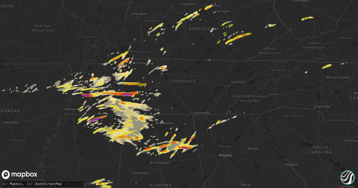
Hail Map in Tennessee on March 27, 2017
Get this storm
March 27 map
$229
one time, instant access
Download today. No call, no setup
Keep the $229
Bought the map and want the full workflow? Apply the entire $229 to a subscription within 7 days. None of it is wasted.
Every map, not just this one
This buys you this map. Subscription and you get every map we run, in the markets you choose from a few cities to whole states to nationwide. Plus real-time alerts the moment a storm fires.
Contact data
Name, contact info, occupancy, even credit band for addresses in the footprint. You go from where it hit to who to call.
Become the source they trust
Unlimited branding weather history reports on demand. You already have the documented answer ready for the property owner, and you are the one who showed up with it.
Property data and RoofTrace estimates
Pull up any address you have got, its value and the exact code rules for that jurisdiction, straight from One Click Code. Then RoofTrace estimates the squares, pitch, and roof value, priced the way you price.
Storm reports in Tennessee
Tennessee
| Date | Description |
|---|---|
| 03/27/20176:25 PM CDT | Trees down on a house on keeton dr. |
| 03/27/20176:20 PM CDT | Quarter size hail ongoing. |
| 03/27/20176:19 PM CDT | Trees down on mccord hollow rd. Apparent damage path extends from hwy 412 northeastward to this location. Possible tornado. |
| 03/27/20176:19 PM CDT | Trees down on mccord hollow rd. Apparent damage path extends from hwy 412 northeastward to this location. Possible tornado. |
| 03/27/20176:13 PM CDT | Tornado started on old hohenwald road. The tornado then crossed highway 412. Most of the damage at this location was to dozens of hardwood and softwood trees uprooted w |
| 03/27/20176:09 PM CDT | Hwy 412 blocked from damage. Possible tornado. |
| 03/27/20176:02 PM CDT | A local report indicates 1.50 inch wind near BOLIVAR |
| 03/27/20176:00 PM CDT | Public reported hail as large as baseball to 3 inches in diameter just south and southeast of linden. Numerous homes and vehicles damaged. |
| 03/27/20175:58 PM CDT | Highway 100 and primm springs rd. In lyles |
| 03/27/20175:56 PM CDT | A local report indicates 1.75 inch wind near LINDEN |
| 03/27/20175:56 PM CDT | Quarter size hail ongoing. |
| 03/27/20175:45 PM CDT | A local report indicates 2.00 inch wind near JACKS CREEK |
| 03/27/20175:42 PM CDT | Dime to quarter size hail in nunnelly |
| 03/27/20175:42 PM CDT | A few trees down near nunnelly. Time estimated based on radar. |
| 03/27/20175:40 PM CDT | Public reported hail of golf ball size with a few stones up to tennis ball size just south of highway 412 along the tennessee river |
| 03/27/20175:33 PM CDT | A local report indicates 1.50 inch wind near BROWNSVILLE |
| 03/27/20175:32 PM CDT | Gutters blown off a factory in celina. |
| 03/27/20175:32 PM CDT | A few trees were blown down outside of celina on hwy 53 s... Hwy 52... And cedar hill rd. |
| 03/27/20175:31 PM CDT | A local report indicates 1.00 inch wind near MEDON |
| 03/27/20175:30 PM CDT | A local report indicates 1.00 inch wind near MEDON |
| 03/27/20175:30 PM CDT | Trees and power lines down. Structural damage. Possible tornado |
| 03/27/20175:30 PM CDT | A tornado caused damage to numerous trees and several outbuildings to the south and southwest of decaturville...mainly along and west of highway 100. This tornado was r |
| 03/27/20175:28 PM CDT | Quarter size hail along highway 412 in parsons |
| 03/27/20175:28 PM CDT | A local report indicates 2.00 inch wind near DECATURVILLE |
| 03/27/20175:26 PM CDT | A local report indicates 1.50 inch wind near PARSONS |
| 03/27/20175:25 PM CDT | Trees and power lines down. Structural damage. Possible tornado |
| 03/27/20175:23 PM CDT | A tree was blown down on mccormick ridge rd. |
| 03/27/20175:17 PM CDT | A local report indicates 1.75 inch wind near BEACON |
| 03/27/20175:15 PM CDT | Ping pong ball size hail at the highway 54 bridge over the hatchie river. |
| 03/27/20175:12 PM CDT | A local report indicates 1.00 inch wind near BEACON |
| 03/27/20175:10 PM CDT | A local report indicates 1.75 inch wind near DARDEN |
| 03/27/20175:05 PM CDT | A local report indicates 1.75 inch wind near LEXINGTON |
| 03/27/20175:03 PM CDT | A local report indicates 1.00 inch wind near BELLS |
| 03/27/20175:00 PM CDT | A local report indicates 1.75 inch wind near 4 NNW REAGAN |
| 03/27/20175:00 PM CDT | Ping pong ball size hail fell in covington. |
| 03/27/20174:59 PM CDT | Tornado in southeast henderson county. Mainly tree damage along ridges. Length about 7 miles. |
| 03/27/20174:57 PM CDT | A local report indicates 1.25 inch wind near LEXINGTON |
| 03/27/20174:52 PM CDT | A local report indicates 1.00 inch wind near LEXINGTON |
| 03/27/20174:51 PM CDT | Power line down on earnest looper rd. Time estimated based on radar. |
| 03/27/20174:41 PM CDT | A local report indicates 1.00 inch wind near 2 W HURON |
| 03/27/20174:41 PM CDT | Multiple power lines down along with damage to a barn at hwy 70 and dyer grimes rd in the double springs area. |
| 03/27/20174:35 PM CDT | A local report indicates a tornado near 6 E JACKSON |
| 03/27/20174:33 PM CDT | A couple of trees were down on epperson springs rd. |
| 03/27/20174:25 PM CDT | Large trees down in gallatin. Report via wsmv tv. |
| 03/27/20174:24 PM CDT | A local report indicates 1.00 inch wind near RIPLEY |
| 03/27/20174:21 PM CDT | A local report indicates 1.50 inch wind near JACKSON |
| 03/27/20174:18 PM CDT | Roof damage was reported at a hanger at the smyrna airport. |
| 03/27/20174:06 PM CDT | Trees down on weeping willow rd. |
| 03/27/20174:01 PM CDT | A local report indicates 1.75 inch wind near MILLERSVILLE |
| 03/27/20174:00 PM CDT | A local report indicates 1.00 inch wind near GOODLETTSVILLE |
| 03/27/20174:00 PM CDT | A local report indicates 1.00 inch wind near JACKSON |
| 03/27/20173:56 PM CDT | A tree fell on a house on lemont dr. |
| 03/27/20173:52 PM CDT | A tspotter report showed a large tree that clipped a house when it fell on pennock ave. |
| 03/27/20173:50 PM CDT | Measured at wtvf-tv in downtown nashville |
| 03/27/20173:48 PM CDT | A tree fell on a house on cephas street. |
| 03/27/20173:48 PM CDT | Tspotter reports showed multiple trees down on west end near the vanderbilt campus. |
| 03/27/20173:47 PM CDT | A large tree fell on multiple parked cars at acklen park dr and fairmont dr. |
| 03/27/20173:45 PM CDT | Occurred at wsmv-tv west of downtown nashville |
| 03/27/20173:41 PM CDT | A tree fell on a moving vehicle on hobbs rd in green hills. No injuries were reported. |
| 03/27/20173:39 PM CDT | Tree down at harding place and northumberland |
| 03/27/20173:39 PM CDT | Tree down on abbot martin rd. |
| 03/27/20173:34 PM CDT | Trees down at temple rd. And highway 100 in bellevue |
| 03/27/20173:31 PM CDT | Tree down at sneed rd and temple rd. |
| 03/27/20173:20 PM CDT | A local report indicates 1.75 inch wind near 5 S TRENTON |
| 03/27/20173:19 PM CDT | Trees down in the southwest part of williamson county including hargrove ridge rd... Greenbriar rd... Pinewood rd... And wilkens branch rd. |
| 03/27/20172:35 PM CDT | A local report indicates 1.50 inch wind near BIG SANDY |
| 03/27/20172:35 PM CDT | A local report indicates 1.00 inch wind near DYERSBURG |
| 03/27/20172:20 PM CDT | A local report indicates 1.75 inch wind near 5 S TRENTON |
| 03/27/20171:58 PM CDT | A local report indicates 1.50 inch wind near 4 NE PARIS |
| 03/27/20171:44 PM CDT | Mainly dime size hail with up to quarter sized hail west of pinson. |
| 03/27/201712:40 PM CDT | A local report indicates 1.75 inch wind near 3 S NEWBERN |
| 03/26/20178:35 PM CDT | One tree down on holliday hills road near south end of douglas lake |
| 03/26/20177:59 PM CDT | Tree down just south and east of highway 43 and old florence pulaski road. |
| 03/26/20177:58 PM CDT | Images of a vehicle flipped and metal roof damage at purcell/s wrecker service. Time estimated based on radar. |
| 03/26/20177:57 PM CDT | Image of a tree that fell on a storage building. Time estimated based on radar. |
| 03/26/20177:25 PM CDT | Public reported golf ball size hail just east of waynesboro |
| 03/26/20177:10 PM CDT | A local report indicates 1.00 inch wind near ADAMSVILLE |
| 03/26/20177:10 PM CDT | A local report indicates 1.50 inch wind near OLIVE HILL |
All States Impacted by Hail Map on March 27, 2017
Cities Impacted by Hail Map on March 27, 2017
- Chatsworth, GA
- Ellijay, GA
- Fairview, TN
- Franklin, TN
- Drasco, AR
- Linden, TN
- Decaturville, TN
- Hustonville, KY
- Glen, MS
- Corinth, MS
- Rienzi, MS
- Holly Pond, AL
- Sikes, LA
- Tullos, LA
- Olla, LA
- New Albany, MS
- Resaca, GA
- Goodlettsville, TN
- White House, TN
- Greenbrier, TN
- Gallatin, TN
- Hendersonville, TN
- Cottontown, TN
- State Road, NC
- Pilot Mountain, NC
- Dobson, NC
- Ararat, NC
- Elkin, NC
- Mount Airy, NC
- Holly Springs, MS
- Lamar, MS
- Michigan City, MS
- Monette, AR
- Black Oak, AR
- Lake City, AR
- Manila, AR
- Dyersburg, TN
- Prospect, TN
- Ardmore, TN
- Flowood, MS
- Brandon, MS
- Caruthersville, MO
- Steele, MO
- Tremont, MS
- Fulton, MS
- Plantersville, MS
- Red Bay, AL
- Hodges, AL
- Hamilton, AL
- Spruce Pine, AL
- Mantachie, MS
- Vina, AL
- Tupelo, MS
- Golden, MS
- Russellville, AL
- Hackleburg, AL
- Killen, AL
- Shepherdsville, KY
- Coxs Creek, KY
- Florence, AL
- Paris, TN
- Buchanan, TN
- Puryear, TN
- Wilson, AR
- Prestonsburg, KY
- Banner, KY
- Allen, KY
- Newbern, TN
- Trenton, TN
- Dyer, TN
- Lake Providence, LA
- Transylvania, LA
- Coldwater, MS
- Byhalia, MS
- Red Banks, MS
- Ripley, TN
- Brownsville, TN
- Gates, TN
- Henning, TN
- Laurel, MS
- Vinemont, AL
- Cullman, AL
- Cadiz, KY
- Bumpus Mills, TN
- Iron City, TN
- Cypress Inn, TN
- Hickory Flat, MS
- Ashland, MS
- Blue Mountain, MS
- Danville, AL
- Guntersville, AL
- Albertville, AL
- Covington, TN
- Lawrenceburg, TN
- Waynesboro, TN
- Horse Branch, KY
- Olaton, KY
- Springville, TN
- Bruceton, TN
- Hollow Rock, TN
- Mansfield, TN
- Big Sandy, TN
- Camden, TN
- Eva, TN
- Lepanto, AR
- Bay, AR
- Caraway, AR
- Hornersville, MO
- Leachville, AR
- Dell, AR
- Osceola, AR
- Bells, TN
- Blytheville, AR
- Jonesboro, AR
- Alamo, TN
- Keiser, AR
- Luxora, AR
- Marked Tree, AR
- Etowah, AR
- Hurricane Mills, TN
- Waverly, TN
- Holladay, TN
- Arab, AL
- Union Grove, AL
- Lake, MS
- Newton, MS
- Forest, MS
- Lawrence, MS
- Trafford, AL
- Oneonta, AL
- Remlap, AL
- Utica, MS
- Edwards, MS
- Marietta, MS
- New Site, MS
- Baldwyn, MS
- Raymond, MS
- Vicksburg, MS
- Port Gibson, MS
- Lexington, TN
- Winnfield, LA
- Cherry Log, GA
- Benton, KY
- Carthage, MS
- Myrtle, MS
- Gadsden, AL
- Wellington, AL
- Baileyton, AL
- Joppa, AL
- Somerset, KY
- New Concord, KY
- Hazel, KY
- Murray, KY
- Radcliff, KY
- Vine Grove, KY
- Hagarville, AR
- Berea, KY
- Stewart, TN
- Cedar Hill, TN
- Chunky, MS
- Hickory, MS
- De Kalb, MS
- Bradford, TN
- Milan, TN
- Atwood, TN
- Double Springs, AL
- Addison, AL
- Houston, AL
- Louin, MS
- Pachuta, MS
- Rose Hill, MS
- Paulding, MS
- Cordova, TN
- Taylorsville, KY
- Huron, TN
- Parsons, TN
- Scotts Hill, TN
- Darden, TN
- Mayersville, MS
- Grant, AL
- Scottsboro, AL
- Haleyville, AL
- Oceana, WV
- Naoma, WV
- Wharton, WV
- Ricetown, KY
- Collinsville, AL
- Attalla, AL
- Tennessee Ridge, TN
- Erin, TN
- Kelly, LA
- London, KY
- Noxapater, MS
- Philadelphia, MS
- Jasper, AL
- Hanceville, AL
- Crane Hill, AL
- Bremen, AL
- Old Hickory, TN
- Madison, TN
- Altoona, AL
- Boaz, AL
- Horton, AL
- Waynesboro, MS
- Blairsville, GA
- Cedar Grove, TN
- Guntown, MS
- Town Creek, AL
- Muscle Shoals, AL
- Rogersville, AL
- Lawrenceburg, KY
- Frankfort, KY
- Waddy, KY
- Shelbyville, KY
- Hartford, KY
- Athens, AL
- Pinola, MS
- Utica, KY
- Farmington, KY
- Ripley, MS
- Mount Hope, WV
- Beckley, WV
- Humboldt, TN
- Batesville, AR
- Friendship, TN
- Pocahontas, TN
- Walnut, MS
- Falkner, MS
- Cherokee, AL
- Bethel Springs, TN
- Beech Bluff, TN
- Finger, TN
- Henderson, TN
- Adamsville, TN
- Enville, TN
- Jacks Creek, TN
- New Hope, AL
- Paint Lick, KY
- Crab Orchard, KY
- Leesburg, AL
- Bankston, AL
- Ohatchee, AL
- Jacksonville, AL
- Crossville, AL
- Centre, AL
- Carbon Hill, AL
- Cedar Bluff, AL
- Kimberly, AL
- Blountsville, AL
- Locust Fork, AL
- Gardendale, AL
- Summerville, GA
- Cleveland, AL
- Townley, AL
- Hayden, AL
- Steele, AL
- Pinson, AL
- Nauvoo, AL
- Berry, AL
- Gallant, AL
- Menlo, GA
- Rainbow City, AL
- Springville, AL
- Warrior, AL
- Gaylesville, AL
- Piedmont, AL
- Ashville, AL
- Odenville, AL
- Lyerly, GA
- Hardin, KY
- Dexter, KY
- Denmark, TN
- Jackson, TN
- Boston, KY
- Culleoka, TN
- Lynnville, TN
- Mount Pleasant, TN
- Summertown, TN
- Calhoun, KY
- Livermore, KY
- Liberty, KY
- Stanford, KY
- Parksville, KY
- Gravel Switch, KY
- Calhoun, GA
- Sugar Valley, GA
- Bolivar, TN
- Bay Springs, MS
- Waterford, MS
- Morganton, GA
- Blue Ridge, GA
- Hernando, MS
- Hayti, MO
- Stringer, MS
- Heidelberg, MS
- Cecilia, KY
- Eastview, KY
- Olivehill, TN
- Mason, TN
- Arlington, TN
- Lynn, AL
- Henry, TN
- Preston, MS
- Tiplersville, MS
- West Point, KY
- Rineyville, KY
- Lebanon Junction, KY
- Clermont, KY
- Elizabethtown, KY
- Versailles, KY
- Belmont, MS
- Saltillo, MS
- Portland, TN
- Fox, AR
- Clinton, AR
- Lyles, TN
- Nunnelly, TN
- Prim, AR
- Lena, MS
- Lewisburg, TN
- Columbia, TN
- Louisville, MS
- Scooba, MS
- Decatur, AL
- Trinity, AL
- Sondheimer, LA
- Cardwell, MO
- Mount Juliet, TN
- Cedartown, GA
- Eads, TN
- Purlear, NC
- Deep Gap, NC
- Sandy Ridge, NC
- Dover, TN
- Murphy, NC
- Oakland, TN
- Richmond, KY
- Lancaster, KY
- Almo, KY
- Sedalia, KY
- Kirksey, KY
- Mayfield, KY
- Stanton, TN
- Luray, TN
- Hohenwald, TN
- Centerville, TN
- Reagan, TN
- Shiloh, TN
- Michie, TN
- Stantonville, TN
- Selmer, TN
- Shirley, AR
- Dodson, LA
- Florence, MS
- Harrisville, MS
- Braxton, MS
- Ellisville, MS
- Booneville, MS
- Collinwood, TN
- Lutts, TN
- Lexington, AL
- Elkmont, AL
- Waterloo, AL
- Anderson, AL
- Vossburg, MS
- Raleigh, MS
- Shubuta, MS
- South Fulton, TN
- Clifton, TN
- Westpoint, TN
- Savannah, TN
- Morris Chapel, TN
- Medon, TN
- Bragg City, MO
- Gobler, MO
- Collierville, TN
- Island, KY
- Rumsey, KY
- Fordsville, KY
- Whitesville, KY
- Caneyville, KY
- Nettleton, MS
- Finley, TN
- Halls, TN
- Winnsboro, LA
- Moscow, TN
- Somerville, TN
- Williston, TN
- Rossville, TN
- Sumiton, AL
- Cordova, AL
- Empire, AL
- Batesburg, SC
- Cash, AR
- Leighton, AL
- Tuscumbia, AL
- Rosie, AR
- Cord, AR
- Magness, AR
- Newark, AR
- Santa Fe, TN
- Middleton, TN
- Mount Hope, AL
- Annville, KY
- East Bernstadt, KY
- Potts Camp, MS
- Olive Branch, MS
- Joelton, TN
- Hillsboro, AL
- Buckatunna, MS
- Millry, AL
- Smithville, MS
- Auburn, KY
- Germantown, TN
- Dwale, KY
- Phil Campbell, AL
- Bear Creek, AL
- Courtland, AL
- Moulton, AL
- Dennard, AR
- Pinson, TN
- Memphis, TN
- Buena Vista, TN
- Jackson, MS
- Richland, MS
- Pearl, MS
- Beaver Dam, KY
- Huntingdon, TN
- McKenzie, TN
- Fairfield, KY
- Dennis, MS
- Gilbert, LA
- McKee, KY
- Martin, TN
- Dukedom, TN
- Fulton, KY
- Manchester, KY
- Booneville, KY
- Sextons Creek, KY
- Mooreville, MS
- Iuka, MS
- Duck River, TN
- Reynolds Station, KY
- Mistletoe, KY
- Tyner, KY
- Oneida, KY
- Dry Creek, WV
- Glen Daniel, WV
- Whitesville, WV
- Saxon, WV
- Rock Creek, WV
- Arnett, WV
- Blue River, KY
- Mount Vernon, KY
- Livingston, KY
- Whiteville, TN
- Saint Joseph, LA
- Newellton, LA
- Bardstown, KY
- Fayetteville, TN
- Taft, TN
- Clarksville, TN
- Adams, TN
- Madison, AL
- Huntsville, AL
- Wingo, KY
- Minor Hill, TN
- Newhebron, MS
- Georgetown, MS
- Hazlehurst, MS
- State University, AR
- Cottage Grove, TN
- Walnut Grove, MS
- Elkton, KY
- Leoma, TN
- Vincent, KY
- Dickson, TN
- Loretto, TN
- Saulsbury, TN
- Leitchfield, KY
- Dora, AL
- Morton, MS
- Thaxton, MS
- Etta, MS
- Blue Springs, MS
- Dawson Springs, KY
- Springfield, KY
- Toone, TN
- Marshall, AR
- Leslie, AR
- Witts Springs, AR
- Hector, AR
- Pelsor, AR
- Mount Judea, AR
- Tilly, AR
- Ethridge, TN
- Big Clifty, KY
- Clarkson, KY
- Pulaski, TN
- Charlotte, AR
- Sulphur Rock, AR
- Cromwell, KY
- Big Rock, TN
- Woodburn, KY
- Franklin, KY
- Dellrose, TN
- Hudson, KY
- Nashville, TN
- Arley, AL
- Logan, AL
- Martin, KY
- Gunlock, KY
- David, KY
- Locust Grove, AR
- Concord, AR
- Floral, AR
- Guthrie, KY
- Hayesville, NC
- Burnsville, MS
- Wesson, MS
- Saltillo, TN
- Hornsby, TN
- Goodspring, TN
- Sardis, TN
- Brilliant, AL
- Tishomingo, MS
- Ramer, TN
- Guys, TN
- Lester, AL
- Guin, AL
- Crump, TN
- Hickory Valley, TN
- Milledgeville, TN
- Winfield, AL
- Detroit, AL
- Sheffield, AL
- Greenwood Springs, MS
- Mercer, TN
- Dumas, MS
- Shannon, MS
- Counce, TN
- Eddyville, KY
- Princeton, KY
- Shuqualak, MS
- Indian Mound, TN
- Fruithurst, AL
- Belvidere, TN
- Trezevant, TN
- Medina, TN
- Lavinia, TN
- Hampshire, TN
- Cave City, AR
- Stanville, KY
- Ivel, KY
- Pikeville, KY
- Akron, AL
- Moundville, AL
- Dyess, AR
- Stoneville, NC
- Mountain View, AR
- Silver Creek, MS
- Newport, AR
- Five Points, TN
- Kennett, MO
- Columbia, LA
- Waco, KY
- Falkville, AL
- Cross Plains, TN
- Eldridge, AL
- Ashland City, TN
- White Bluff, TN
- Charlotte, TN
- Pleasant View, TN
- Young Harris, GA
- White Plains, KY
- Central City, KY
- Centertown, KY
- Sacramento, KY
- Bremen, KY
- Pisgah, AL
- Browder, KY
- Drakesboro, KY
- Belton, KY
- Brighton, TN
- Spring Hill, TN
- Jena, LA
- Edmonton, KY
- Russellville, KY
- Tanner, AL
- Sylacauga, AL
- Gleason, TN
- Edgemont, AR
- Pall Mall, TN
- Rutherford, TN
- Greenfield, TN
- Gadsden, TN
- Ridgely, TN
- Paragould, AR
- Brookland, AR
- Trumann, AR
- Palmersville, TN
- Westport, TN
- Only, TN
- McEwen, TN
- Hermanville, MS
- Bolton, MS
- Cisco, GA
- Grayson, LA
- Eubank, KY
- Nancy, KY
- Science Hill, KY
- Irvine, KY
- Brodhead, KY
- Buckhorn, KY
- Gays Creek, KY
- Jackson, KY


