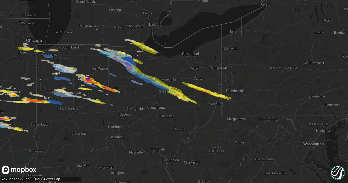
Hail Map in Ohio on March 26, 2026
Get this storm
March 26 map
$229
one time, instant access
Download today. No call, no setup
Keep the $229
Bought the map and want the full workflow? Apply the entire $229 to a subscription within 7 days. None of it is wasted.
Every map, not just this one
This buys you this map. Subscription and you get every map we run, in the markets you choose from a few cities to whole states to nationwide. Plus real-time alerts the moment a storm fires.
Contact data
Name, contact info, occupancy, even credit band for addresses in the footprint. You go from where it hit to who to call.
Become the source they trust
Unlimited branding weather history reports on demand. You already have the documented answer ready for the property owner, and you are the one who showed up with it.
Property data and RoofTrace estimates
Pull up any address you have got, its value and the exact code rules for that jurisdiction, straight from One Click Code. Then RoofTrace estimates the squares, pitch, and roof value, priced the way you price.
Storm reports in Ohio
Ohio
| Date | Description |
|---|---|
| 03/26/20266:58 PM CDT | 3 power poles partially down along with branches. |
| 03/26/20266:56 PM CDT | Report from mping: quarter |
| 03/26/20266:52 PM CDT | Large tree uprooted in cairo near sr 65. Time estimated via radar. |
| 03/26/20266:52 PM CDT | 3/4 in to 1 in hail reported for appx. 1 minute. |
| 03/26/20266:48 PM CDT | Report on facebook of trees snapped and a tree down on home in gomer. Public estimated time of 745 pm... Radar estimates closer to 748 pm. |
| 03/26/20266:48 PM CDT | A local report indicates 1.75 inch wind near 1 NW Van Buren |
| 03/26/20266:44 PM CDT | Report from mping: quarter |
| 03/26/20266:43 PM CDT | A local report indicates 1.00 inch wind near 5 NW Rocky Ridge |
| 03/26/20266:37 PM CDT | Photo on facebook showing quarter size hail in leipsic. Time estimated via radar. |
| 03/26/20266:36 PM CDT | A local report indicates 1.00 inch wind near 2 E Prentiss |
| 03/26/20266:36 PM CDT | A local report indicates 1.75 inch wind near Ottawa |
| 03/26/20266:35 PM CDT | A local report indicates 1.00 inch wind near Belmore |
| 03/26/20266:33 PM CDT | Report from mping: golf ball |
| 03/26/20266:32 PM CDT | Report from mping: quarter |
| 03/26/20266:30 PM CDT | Photos relayed by broadcast media of a home damaged in hamler due to 2 inch hail. |
| 03/26/20266:30 PM CDT | Tree down near intersection of walnut and third street. Powerlines were also downed in that area. No information on tree size or health available. |
| 03/26/20266:30 PM CDT | Semi blown over on us-30 with possible injuries. |
| 03/26/20266:28 PM CDT | Delayed report of tree damage near 2nd and 3rd streets in van wert... Oh. |
| 03/26/20266:27 PM CDT | Report from mping: half dollar |
| 03/26/20266:25 PM CDT | A local report indicates 60 MPH wind near Convoy |
| 03/26/20266:25 PM CDT | A local report indicates 1.00 inch wind near 1 E Sylvania |
| 03/26/20266:24 PM CDT | Picture of hailstones measuring 2 inches in diameter in holgate. Time estimated via radar. |
| 03/26/20266:23 PM CDT | Roof damage in fowler... Oh |
| 03/26/20266:23 PM CDT | Corrects previous tstm wnd dmg report from 3 nne vienna. Roof damage confirmed from an outbuilding roof. |
| 03/26/20266:20 PM CDT | Reported by trained spotter. |
| 03/26/20266:17 PM CDT | Dime to quarter sized hail. |
| 03/26/20266:17 PM CDT | A local report indicates 1.00 inch wind near 3 S Wauseon |
| 03/26/20266:14 PM CDT | A local report indicates 1.00 inch wind near 3 SW Ottawa Lake |
| 03/26/20266:13 PM CDT | A local report indicates 1.50 inch wind near Defiance |
| 03/26/20266:13 PM CDT | Photo on facebook showing a hailstone the size of a golf ball. Time estimated via radar. |
| 03/26/20266:12 PM CDT | Time estimated via radar. Photo on facebook of quarter size hail. |
| 03/26/20266:12 PM CDT | Photo on facebook showing numerous quarter size hailstones in ayersville. Time estimated via radar. |
| 03/26/20266:12 PM CDT | Between half dollar and ping pong sized hail. |
| 03/26/20266:12 PM CDT | Time estimated from radar. |
| 03/26/20266:12 PM CDT | A local report indicates 1.00 inch wind near 3 NNE Brunersburg |
| 03/26/20266:11 PM CDT | Report from mping: golf ball |
| 03/26/20266:10 PM CDT | Hail around half-dollar to ping pong sized. |
| 03/26/20266:10 PM CDT | Trees and powerlines down on marks road between sleepy hollow and gayer. |
| 03/26/20266:09 PM CDT | . |
| 03/26/20266:09 PM CDT | A local report indicates 1.00 inch wind near Ney |
| 03/26/20266:08 PM CDT | Hail between quarter and golf ball size reported just after 7 pm in brunersburg. |
| 03/26/20266:07 PM CDT | A local report indicates 1.00 inch wind near Stryker |
| 03/26/20266:06 PM CDT | Broadcast media relays photos of golf ball size hail in ney. Time estimated via radar. |
| 03/26/20266:05 PM CDT | Reports of trees downed in bryan. Time estimated from radar. |
| 03/26/20266:05 PM CDT | A local report indicates 1.75 inch wind near 1 NNW Bryan |
| 03/26/20266:02 PM CDT | Time estimated via radar. |
| 03/26/20266:01 PM CDT | Photo on facebook showing several hailstones of quarter size with a few ping pong ball size ones mixed in as well. Time estimated via radar. |
| 03/26/20266:01 PM CDT | Powerlines down on sr 15 near bryan. Time estimated via radar. |
| 03/26/20266:00 PM CDT | A local report indicates 1.50 inch wind near Bryan |
| 03/26/20266:00 PM CDT | . |
| 03/26/20266:00 PM CDT | Time estimated via radar. |
| 03/26/20266:00 PM CDT | Powerlines down on county road g between county rd 13 and county rd 15. Time estimated via radar. |
| 03/26/20266:00 PM CDT | A local report indicates 1.00 inch wind near 2 NW Bryan |
| 03/26/20265:54 PM CDT | Time estimated via radar. |
| 03/25/20268:35 PM CDT | A local report indicates 1.00 inch wind near 4 W Coshocton |
| 03/25/20268:34 PM CDT | Report from mping: quarter |
| 03/25/20268:32 PM CDT | Pea to quarter size hail. |
| 03/25/20268:30 PM CDT | Time estimated from radar. |
| 03/25/20268:26 PM CDT | Report from mping: ping pong ball |
| 03/25/20268:23 PM CDT | Report from mping: quarter |
| 03/25/20268:20 PM CDT | A local report indicates 1.00 inch wind near 3 NE Bloomingdale |
| 03/25/20268:20 PM CDT | A local report indicates 1.00 inch wind near Bloomingdale |
| 03/25/20268:20 PM CDT | Time estimated from radar. |
| 03/25/20268:20 PM CDT | Time estimated from radar. |
| 03/25/20268:04 PM CDT | A local report indicates 1.00 inch wind near 3 S Butler |
| 03/25/20268:04 PM CDT | A few calls for downed trees and powerlines in the mt vernon area. |
| 03/25/20268:02 PM CDT | Sporadic trees down across knox county. Most of the down trees were observed in fredericktown and mount vernon. Time estimated via radar. |
| 03/25/20268:00 PM CDT | Report from mping: quarter |
| 03/25/20267:57 PM CDT | Power lines down. Time estimated from radar. |
| 03/25/20267:56 PM CDT | Tree downed on a house near fredericktown. |
| 03/25/20267:56 PM CDT | A brief ef-0 tornado with maximum wind speeds of 75 mph and a maximum width of 20 yards began just west of granny creek road southwest of fredricktown. The tornado ripp |
| 03/25/20267:52 PM CDT | Time estimated from radar. |
| 03/25/20267:51 PM CDT | Barn blown down on byrket road. Time estimated from radar. |
| 03/25/20267:48 PM CDT | Damage to the roof of a building at hidden lakes campground. A few branches also broken off at the campground. |
| 03/25/20267:45 PM CDT | Lines down on 347 and jackson. Time estimated from radar. |
| 03/25/20267:45 PM CDT | Several trees down on two properties off of township road 96. Time estimated via radar. |
| 03/25/20267:43 PM CDT | A local report indicates 1.50 inch wind near New Philadelphia |
| 03/25/20267:43 PM CDT | Trees and powerlines down near candlewood lake. |
| 03/25/20267:42 PM CDT | Trees downed. |
| 03/25/20267:42 PM CDT | Tree downed. |
| 03/25/20267:41 PM CDT | An ef-1 tornado with maximum wind speeds of 95 mph and a maximum width of 75 yards began northeast of mount gilead along us 42 near home road... Causing extensive tree |
| 03/25/20267:40 PM CDT | Roof damage; time rough estimate from caller. |
| 03/25/20267:40 PM CDT | Trees down. |
| 03/25/20267:38 PM CDT | Time estimated from radar. |
| 03/25/20267:34 PM CDT | Power lines and poles down on wegner road. Time estimated from radar. |
| 03/25/20267:33 PM CDT | Trees and powerlines down north of waldo. |
| 03/25/20267:32 PM CDT | Trees downed south of bucyrus. |
| 03/25/20267:32 PM CDT | Power lines down on 705. Time estimated from radar. |
| 03/25/20267:30 PM CDT | Roof blown off barn. Time estimated from radar. |
| 03/25/20267:30 PM CDT | Wind destroyed barn and some outbuildings at local residence. Estimated wind speeds of 60 to 70mph based on images provided. |
| 03/25/20267:27 PM CDT | Poles down on boundary road. Time estimated from radar. |
| 03/25/20267:22 PM CDT | Small tree downed. |
| 03/25/20267:20 PM CDT | Utility pole down on 12000 sanders road. Time estimated from radar. |
| 03/25/20267:17 PM CDT | Poles down on 274. Time estimated from radar. |
| 03/25/20267:15 PM CDT | Trees downed in harpster township. Time estimated via radar. |
| 03/25/20267:11 PM CDT | Quarter size hail at intersection of st rt 18 and twn rd 47. |
| 03/25/20267:10 PM CDT | Two large trees fell onto and through two separate mobile homes in the same neighborhood. One resident was trapped in one of the mobile homes but was not seriously inju |
| 03/25/20267:08 PM CDT | Trees downed in northern marseilles township. Time estimated via radar. |
| 03/25/20267:07 PM CDT | Metal roof blew onto us68 south of town. |
| 03/25/20267:07 PM CDT | Roof of a pre-fabricated shed blew off. |
All States Impacted by Hail Map on March 26, 2026
Cities Impacted by Hail Map on March 26, 2026
- Homer Glen, IL
- Orland Park, IL
- Palos Park, IL
- Alsip, IL
- Palos Heights, IL
- Crestwood, IL
- Midlothian, IL
- Blue Island, IL
- Riverdale, IL
- Robbins, IL
- Cissna Park, IL
- Milford, IL
- Lemont, IL
- Oak Forest, IL
- Posen, IL
- Minier, IL
- Willow Springs, IL
- Stanford, IL
- Bloomington, IL
- Danvers, IL
- Gary, IN
- Hobart, IN
- Lake Station, IN
- Shirley, IL
- Highland, IN
- Munster, IN
- Hammond, IN
- Griffith, IN
- Homewood, IL
- Glenwood, IL
- Harvey, IL
- Chicago, IL
- Schererville, IN
- Danforth, IL
- Lowell, IN
- Crown Point, IN
- Hebron, IN
- Kentland, IN
- Lansing, IL
- Chicago Heights, IL
- Thornton, IL
- Valparaiso, IN
- San Pierre, IN
- North Judson, IN
- Medaryville, IN
- Winamac, IN
- Wanatah, IN
- Monterey, IN
- Francesville, IN
- Watseka, IL
- Gilman, IL
- Crescent City, IL
- Athens, MI
- East Leroy, MI
- Ellsworth, IL
- Downs, IL
- Le Roy, IL
- Bellflower, IL
- Wheatfield, IN
- La Crosse, IN
- Kouts, IN
- Monon, IN
- Arrowsmith, IL
- Maumee, OH
- Star City, IN
- Kewanna, IN
- Rochester, IN
- Lagrange, IN
- Knox, IN
- Ora, IN
- Culver, IN
- Monticello, IN
- Foosland, IL
- Macy, IN
- Hudson, IN
- Pleasant Lake, IN
- Ashley, IN
- Corunna, IN
- Waterloo, IN
- Lafayette, IN
- Dayton, IN
- Rossville, IN
- Mulberry, IN
- Wolcottville, IN
- Orland, IN
- Bronson, MI
- Angola, IN
- Howe, IN
- Carlock, IL
- McLean, IL
- Akron, IN
- Normal, IL
- Mackinaw, IL
- Rossville, IL
- Alvin, IL
- Cortland, OH
- Vienna, OH
- Fowler, OH
- Hamilton, IN
- Butler, IN
- Edon, OH
- Edgerton, OH
- Bryan, OH
- Hicksville, OH
- Montpelier, OH
- Burghill, OH
- Frankfort, IN
- Lagro, IN
- Andrews, IN
- Heyworth, IL
- Delphi, IN
- Towanda, IL
- Williamsport, IN
- West Lebanon, IN
- Saint Joseph, IL
- Urbana, IL
- Huntington, IN
- Wabash, IN
- La Fontaine, IN
- Peru, IN
- Denver, IN
- Roann, IN
- Armstrong, IL
- Fithian, IL
- Veedersburg, IN
- Mellott, IN
- Wingate, IN
- Waynetown, IN
- Hillsboro, IN
- Crawfordsville, IN
- New Richmond, IN
- Ney, OH
- Warren, IN
- Sherwood, OH
- Van Buren, IN
- Marion, IN
- Defiance, OH
- Evansport, OH
- Stryker, OH
- Archbold, OH
- Napoleon, OH
- Wauseon, OH
- Ridgeville Corners, OH
- Fisher, IL
- West Unity, OH
- Collison, IL
- Oakwood, IL
- Danville, IL
- Urbana, IN
- North Manchester, IN
- Saybrook, IL
- Anchor, IL
- Palmyra, MI
- Blissfield, MI
- Adrian, MI
- Woodridge, IL
- La Grange, IL
- Westmont, IL
- Downers Grove, IL
- Darien, IL
- Willowbrook, IL
- Lockport, IL
- Ogden, IL
- Royal, IL
- Michigantown, IN
- Cutler, IN
- Bringhurst, IN
- Forest, IN
- Jasper, MI
- Liberty Center, OH
- Mark Center, OH
- Clayton, MI
- Attica, IN
- Linden, IN
- Darlington, IN
- Bluffton, IN
- Liberty Center, IN
- Poneto, IN
- Holgate, OH
- New Bavaria, OH
- Leipsic, OH
- Miller City, OH
- Continental, OH
- Dewey, IL
- Ottawa, OH
- Hamler, OH
- Bismarck, IL
- Covington, IN
- Delta, OH
- Lebanon, IN
- Thorntown, IN
- Jamestown, IN
- Gibson City, IL
- Mahomet, IL
- Farmer City, IL
- Paxton, IL
- Ludlow, IL
- Russiaville, IN
- Buck Creek, IN
- Tipton, IN
- Sharpsville, IN
- Goldsmith, IN
- Kempton, IN
- Perrysburg, OH
- Lambertville, MI
- Riga, MI
- Ottawa Lake, MI
- Petersburg, MI
- Temperance, MI
- Deerfield, MI
- Rantoul, IL
- Windfall, IN
- Markle, IN
- Mansfield, IL
- Dolton, IL
- Colfax, IL
- Keystone, IN
- Petroleum, IN
- Montpelier, IN
- Toledo, OH
- Oregon, OH
- Northwood, OH
- Deshler, OH
- McComb, OH
- Geneva, IN
- Bryant, IN
- Harbor View, OH
- Elwood, IN
- Reynolds, IN
- Erie, MI
- Curtice, OH
- Bowling Green, OH
- Weston, OH
- Potomac, IL
- Summitville, IN
- Alexandria, IN
- East Chicago, IN
- Walbridge, OH
- Rossford, OH
- Millbury, OH
- Sylvania, OH
- Portland, IN
- Coldwater, OH
- Fort Recovery, OH
- Celina, OH
- Frankton, IN
- Oak Harbor, OH
- Martin, OH
- Cygnet, OH
- Custar, OH
- Rudolph, OH
- Portage, OH
- North Baltimore, OH
- Port Clinton, OH
- Graytown, OH
- Penfield, IL
- Yorktown, IN
- Anderson, IN
- Michigan City, IN
- La Porte, IN
- Westville, IN
- Chesterton, IN
- Mount Cory, OH
- Findlay, OH
- Benton Ridge, OH
- Rawson, OH
- Pandora, OH
- Columbus Grove, OH
- Bluffton, OH
- Milton Center, OH
- Wayne, OH
- Jerry City, OH
- Bloomdale, OH
- Fostoria, OH
- Muncie, IN
- Van Buren, OH
- Selma, IN
- Parker City, IN
- Farmland, IN
- Losantville, IN
- Arcadia, OH
- Jenera, OH
- Arlington, OH
- Alvada, OH
- Vanlue, OH
- Carey, OH
- Mount Blanchard, OH
- Williamstown, OH
- Forest, OH
- Wharton, OH
- Saint Henry, OH
- Dunkirk, OH
- Upper Sandusky, OH
- Kirby, OH
- Nevada, OH
- Daleville, IN
- Newtown, IN
- Flora, IN
- Malinta, OH
- McClure, OH
- Perrysville, IN
- Greentown, IN
- Converse, IN
- Swayzee, IN
- Winchester, IN
- Modoc, IN
- Maria Stein, OH
- Bucyrus, OH
- Harpster, OH
- Morral, OH
- Marion, OH
- Chickasaw, OH
- New Bremen, OH
- Shreve, OH
- Holmesville, OH
- Fredericksburg, OH
- Jonesboro, IN
- Gas City, IN
- Millersburg, OH
- Dundee, OH
- Wilmot, OH
- Beach City, OH
- Sugarcreek, OH
- Strasburg, OH
- Lynn, IN
- Bolivar, OH
- Dover, OH
- Grelton, OH
- Grand Rapids, OH
- Hoytville, OH
- Minster, OH
- Bolingbrook, IL
- Romeoville, IL
- Tinley Park, IL
- Markham, IL
- Clarendon Hills, IL
- Justice, IL
- Palos Hills, IL
- Worth, IL
- Summit Argo, IL
- Western Springs, IL
- Hinsdale, IL
- Westpoint, IN
- Romney, IN
- Upland, IN
- Hartford City, IN
- New Philadelphia, OH
- Mineral City, OH
- Caledonia, OH
- Galion, OH
- Edison, OH
- Mansfield, OH
- Mount Gilead, OH
- Amboy, IN
- Calumet City, IL
- Dennison, OH
- Sherrodsville, OH
- Bowerston, OH
- Leesville, OH
- Fredericktown, OH
- Bellville, OH
- Butler, OH
- Danville, OH
- Howard, OH
- Mount Vernon, OH
- Plainfield, IL
- Naperville, IL
- Carrollton, OH
- Scio, OH
- Jewett, OH
- Amsterdam, OH
- Hopedale, OH
- Pennville, IN
- South Whitley, IN
- Bloomingdale, OH
- Blue Mound, IL
- Stonington, IL
- Glenmont, OH
- Moweaqua, IL
- Macon, IL
- Brinkhaven, OH
- Steubenville, OH
- Waverly, IL
- Walhonding, OH
- Gambier, OH
- Divernon, IL
- Virden, IL
- Auburn, IL
- Pawnee, IL
- Glenarm, IL
- South Holland, IL
- Dalton City, IL
- Bethany, IL
- Richmond, OH
- Mingo Junction, OH
- Follansbee, WV
- Rayland, OH
- Dillonvale, OH
- Wellsburg, WV
- Brilliant, OH
- Avella, PA
- Burgettstown, PA
- Colliers, WV
- Warsaw, OH
- Coshocton, OH
- Edinburg, IL
- Taylorville, IL
- Kincaid, IL
- Morrisonville, IL
- Bulpitt, IL
- Tovey, IL
- Fairmount, IL
- Cantril, IA
- Keosauqua, IA
- Milton, IA
- Sullivan, IL
- Bethany, WV
- Hickory, PA
- Washington, PA
- Canonsburg, PA
- Killbuck, OH
- Mount Sterling, IA
- Bonaparte, IA
- Owaneco, IL
- Palmer, IL
- Arbela, MO
- Dresden, OH
- Conesville, OH
- Adamsville, OH
- Kimbolton, OH
- Newcomerstown, OH
- Arthur, IL
- West Lafayette, OH
- Plainfield, OH
- New Concord, OH
- Luray, MO
- Cambridge, OH
- Kahoka, MO
- Farmington, IA
- Meadow Lands, PA
- Houston, PA
- Lore City, OH
- Donnellson, IA
- Pana, IL
- Beason, IL
- Assumption, IL
- Tower Hill, IL
- Clinton, IL
- Kenney, IL
- Pulaski, IA
- Nokomis, IL
- Rosamond, IL
- Frazeysburg, OH
- Shelbyville, IL
- Lakewood, IL
- Findlay, IL
- Windsor, IL
- Strasburg, IL
- Strabane, PA
- Eighty Four, PA
- Argyle, IA
- Sibley, IL
- Pleasant Plains, IL
- Wayland, MO
- Trilla, IL
- Lerna, IL
- Toledo, IL
- Greenup, IL
- De Land, IL
- Weldon, IL
- Mattoon, IL
- Gays, IL
- Neoga, IL
- Casey, IL
- White Heath, IL
- Seymour, IL
- Mechanicsburg, IL
- Mount Auburn, IL
- Cooksville, IL
- Champaign, IL
- Martinsville, IL
- Bondville, IL
- Luna Pier, MI
- Colchester, IL
- Macomb, IL
- Muncie, IL
- Lovington, IL
- Humboldt, IL
- Arcola, IL
- Genoa, OH
- Dunkirk, IN
- Ridgeville, IN
- Union City, IN
- Van Wert, OH
- Convoy, OH
- Walton, IN
- Royal Center, IN
- Burnettsville, IN
- Idaville, IN
- Logansport, IN
- Galveston, IN
- Kenton, OH
- McGuffey, OH
- Mount Victory, OH
- Ada, OH
- Harrod, OH
- Alger, OH
- Cardington, OH
- La Rue, OH
- Chesterville, OH
- New Madison, OH
- Greenville, OH
- Arcanum, OH
- Williston, OH
- Lacarne, OH
- Rocky Ridge, OH
- Lima, OH


