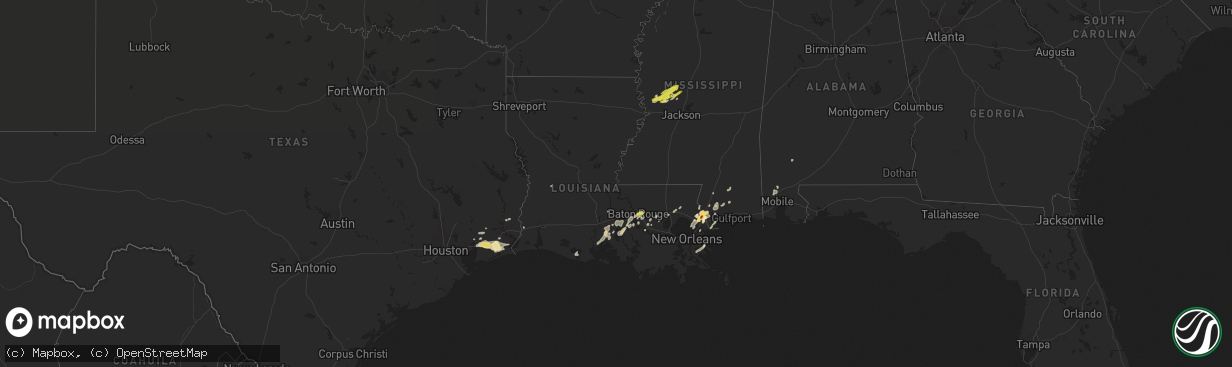
Hail Map in Louisiana on March 25, 2017
The weather event in Louisiana on March 25, 2017 includes Hail map. 4 states and 71 cities were impacted and suffered possible damage. The total estimated number of properties impacted is 15,839.
Want more than just the map?
Turn this storm into a full workflow.
- Owner + property data so you know who to knock
- OnDemand branded weather history reports to win the "did we even have hail?" argument
- RoofTrace estimate so reps stop guessing numbers at the door
Bought this map? Upgrade within 7 days and we'll credit the $230. (10-15 min setup call)
Hail
15,839
Estimated number of impacted properties by a 1.00" hail or larger726
Estimated number of impacted properties by a 1.75" hail or larger0
Estimated number of impacted properties by a 2.50" hail or largerStorm reports in Louisiana
Louisiana
| Date | Description |
|---|---|
| 03/25/20171:57 PM CDT | Fences blown down... A few shingles blown off... And some tree damage near oak leaf drive in cross gates subdivision |
| 03/25/20171:47 PM CDT | Golf ball sized hail reported in the honey island swamp |
| 03/25/20171:40 PM CDT | A local report indicates 1.75 inch wind near PEARL RIVER |
| 03/25/201711:42 AM CDT | Penny to quarter size hail around the intersection of old hammond hwy and millerville rd. |
| 03/25/201711:20 AM CDT | 1 inch hail reported near corporate blvd and jefferson highway |
| 03/25/20178:03 AM CDT | Trees blown down north of vinton. |
All States Impacted by Hail Map on March 25, 2017
Cities Impacted by Hail Map on March 25, 2017
- Slidell, LA
- Stennis Space Center, MS
- Saucier, MS
- Yazoo City, MS
- Buna, TX
- Axis, AL
- Pearl River, LA
- Baton Rouge, LA
- Winnie, TX
- Bay Saint Louis, MS
- Denham Springs, LA
- Prairieville, LA
- Bentonia, MS
- Beaumont, TX
- New Orleans, LA
- Satsuma, AL
- Saraland, AL
- Eight Mile, AL
- Picayune, MS
- Saint Martinville, LA
- Anahuac, TX
- Hankamer, TX
- Port Arthur, TX
- Hamshire, TX
- Devers, TX
- Gonzales, LA
- Flora, MS
- Grosse Tete, LA
- Poplarville, MS
- Kiln, MS
- Darrow, LA
- Perkinston, MS
- Saint Bernard, LA
- Wiggins, MS
- Lacombe, LA
- Vinton, LA
- Plaquemine, LA
- White Castle, LA
- Benton, MS
- Jeanerette, LA
- New Iberia, LA
- Krotz Springs, LA
- Springfield, LA
- Redwood, MS
- Tinsley, MS
- Satartia, MS
- Liberty, TX
- Folsom, LA
- Covington, LA
- Ponchatoula, LA
- Robert, LA
- Loranger, LA
- Saint Gabriel, LA
- Sunshine, LA
- Maurepas, LA
- Wallisville, TX
- Loreauville, LA
- Hull, TX
- Carriere, MS
- Erath, LA
- Saint Amant, LA
- Kaplan, LA
- Jackson, AL
- Gainestown, AL
- Sour Lake, TX
- Addis, LA
- Brusly, LA
- Pitkin, LA
- Livingston, LA
- Valley Park, MS
- Vicksburg, MS


